Jizhou Huang
DuETA: Traffic Congestion Propagation Pattern Modeling via Efficient Graph Learning for ETA Prediction at Baidu Maps
Aug 15, 2022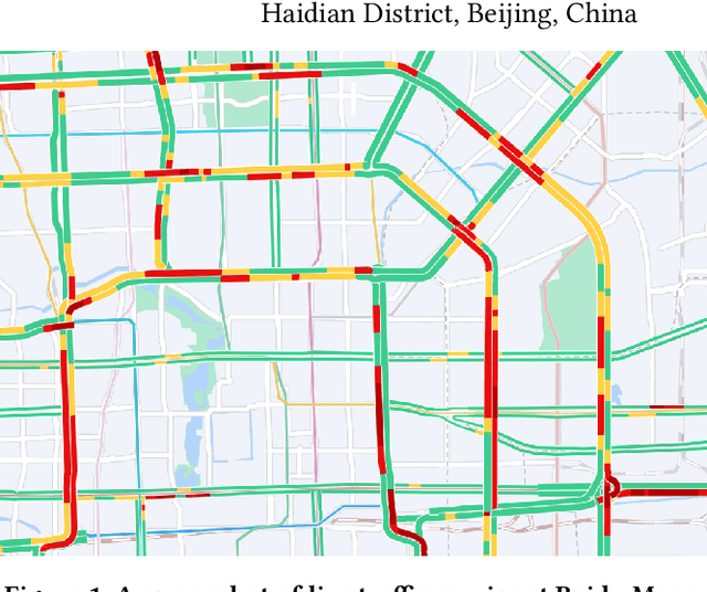

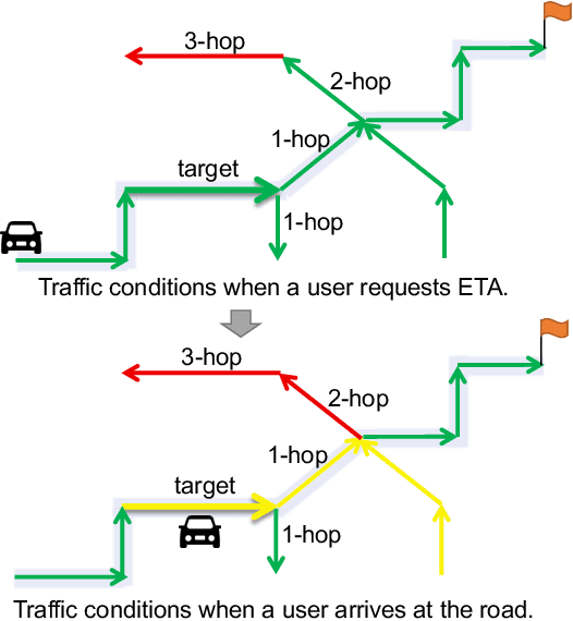

Abstract:Estimated time of arrival (ETA) prediction, also known as travel time estimation, is a fundamental task for a wide range of intelligent transportation applications, such as navigation, route planning, and ride-hailing services. To accurately predict the travel time of a route, it is essential to take into account both contextual and predictive factors, such as spatial-temporal interaction, driving behavior, and traffic congestion propagation inference. The ETA prediction models previously deployed at Baidu Maps have addressed the factors of spatial-temporal interaction (ConSTGAT) and driving behavior (SSML). In this work, we focus on modeling traffic congestion propagation patterns to improve ETA performance. Traffic congestion propagation pattern modeling is challenging, and it requires accounting for impact regions over time and cumulative effect of delay variations over time caused by traffic events on the road network. In this paper, we present a practical industrial-grade ETA prediction framework named DuETA. Specifically, we construct a congestion-sensitive graph based on the correlations of traffic patterns, and we develop a route-aware graph transformer to directly learn the long-distance correlations of the road segments. This design enables DuETA to capture the interactions between the road segment pairs that are spatially distant but highly correlated with traffic conditions. Extensive experiments are conducted on large-scale, real-world datasets collected from Baidu Maps. Experimental results show that ETA prediction can significantly benefit from the learned traffic congestion propagation patterns. In addition, DuETA has already been deployed in production at Baidu Maps, serving billions of requests every day. This demonstrates that DuETA is an industrial-grade and robust solution for large-scale ETA prediction services.
ERNIE-GeoL: A Geography-and-Language Pre-trained Model and its Applications in Baidu Maps
Apr 06, 2022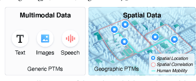

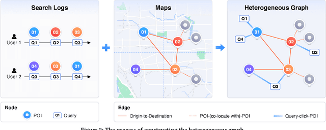

Abstract:Pre-trained models (PTMs) have become a fundamental backbone for downstream tasks in natural language processing and computer vision. Despite initial gains that were obtained by applying generic PTMs to geo-related tasks at Baidu Maps, a clear performance plateau over time was observed. One of the main reasons for this plateau is the lack of readily available geographic knowledge in generic PTMs. To address this problem, in this paper, we present ERNIE-GeoL, which is a geography-and-language pre-trained model designed and developed for improving the geo-related tasks at Baidu Maps. ERNIE-GeoL is elaborately designed to learn a universal representation of geography-language by pre-training on large-scale data generated from a heterogeneous graph that contains abundant geographic knowledge. Extensive quantitative and qualitative experiments conducted on large-scale real-world datasets demonstrate the superiority and effectiveness of ERNIE-GeoL. ERNIE-GeoL has already been deployed in production at Baidu Maps since April 2021, which significantly benefits the performance of a wide range of downstream tasks. This demonstrates that ERNIE-GeoL can serve as a fundamental backbone for geo-related tasks.
Adversarial Neural Trip Recommendation
Sep 24, 2021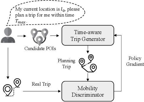
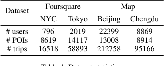
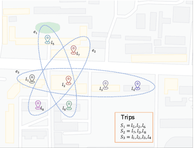

Abstract:Trip recommender system, which targets at recommending a trip consisting of several ordered Points of Interest (POIs), has long been treated as an important application for many location-based services. Currently, most prior arts generate trips following pre-defined objectives based on constraint programming, which may fail to reflect the complex latent patterns hidden in the human mobility data. And most of these methods are usually difficult to respond in real time when the number of POIs is large. To that end, we propose an Adversarial Neural Trip Recommendation (ANT) framework to tackle the above challenges. First of all, we devise a novel attention-based encoder-decoder trip generator that can learn the correlations among POIs and generate well-designed trips under given constraints. Another novelty of ANT relies on an adversarial learning strategy integrating with reinforcement learning to guide the trip generator to produce high-quality trips. For this purpose, we introduce a discriminator, which distinguishes the generated trips from real-life trips taken by users, to provide reward signals to optimize the generator. Moreover, we devise a novel pre-train schema based on learning from demonstration, which speeds up the convergence to achieve a sufficient-and-efficient training process. Extensive experiments on four real-world datasets validate the effectiveness and efficiency of our proposed ANT framework, which demonstrates that ANT could remarkably outperform the state-of-the-art baselines with short response time.
GEDIT: Geographic-Enhanced and Dependency-Guided Tagging for Joint POI and Accessibility Extraction at Baidu Maps
Aug 20, 2021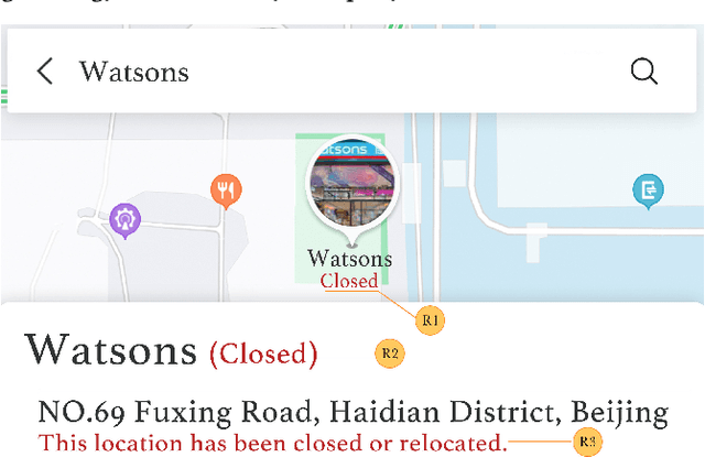
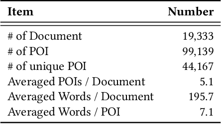
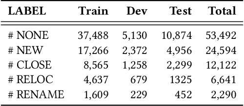

Abstract:Providing timely accessibility reminders of a point-of-interest (POI) plays a vital role in improving user satisfaction of finding places and making visiting decisions. However, it is difficult to keep the POI database in sync with the real-world counterparts due to the dynamic nature of business changes. To alleviate this problem, we formulate and present a practical solution that jointly extracts POI mentions and identifies their coupled accessibility labels from unstructured text. We approach this task as a sequence tagging problem, where the goal is to produce <POI name, accessibility label> pairs from unstructured text. This task is challenging because of two main issues: (1) POI names are often newly-coined words so as to successfully register new entities or brands and (2) there may exist multiple pairs in the text, which necessitates dealing with one-to-many or many-to-one mapping to make each POI coupled with its accessibility label. To this end, we propose a Geographic-Enhanced and Dependency-guIded sequence Tagging (GEDIT) model to concurrently address the two challenges. First, to alleviate challenge #1, we develop a geographic-enhanced pre-trained model to learn the text representations. Second, to mitigate challenge #2, we apply a relational graph convolutional network to learn the tree node representations from the parsed dependency tree. Finally, we construct a neural sequence tagging model by integrating and feeding the previously pre-learned representations into a CRF layer. Extensive experiments conducted on a real-world dataset demonstrate the superiority and effectiveness of GEDIT. In addition, it has already been deployed in production at Baidu Maps. Statistics show that the proposed solution can save significant human effort and labor costs to deal with the same amount of documents, which confirms that it is a practical way for POI accessibility maintenance.
DOLG: Single-Stage Image Retrieval with Deep Orthogonal Fusion of Local and Global Features
Aug 11, 2021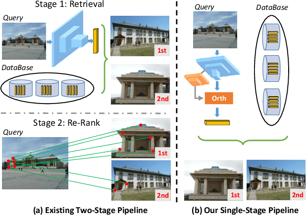
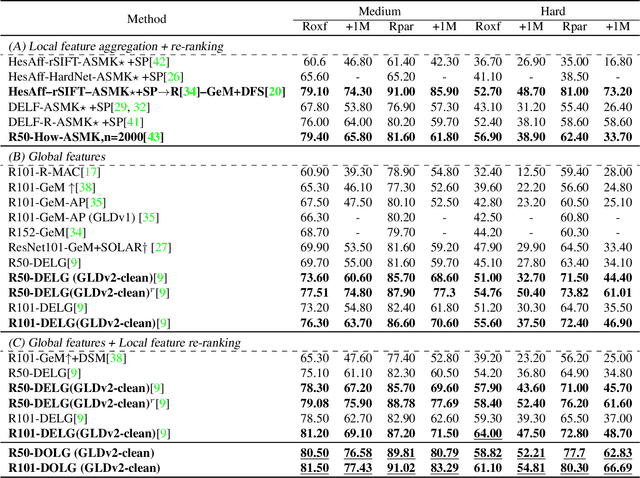


Abstract:Image Retrieval is a fundamental task of obtaining images similar to the query one from a database. A common image retrieval practice is to firstly retrieve candidate images via similarity search using global image features and then re-rank the candidates by leveraging their local features. Previous learning-based studies mainly focus on either global or local image representation learning to tackle the retrieval task. In this paper, we abandon the two-stage paradigm and seek to design an effective single-stage solution by integrating local and global information inside images into compact image representations. Specifically, we propose a Deep Orthogonal Local and Global (DOLG) information fusion framework for end-to-end image retrieval. It attentively extracts representative local information with multi-atrous convolutions and self-attention at first. Components orthogonal to the global image representation are then extracted from the local information. At last, the orthogonal components are concatenated with the global representation as a complementary, and then aggregation is performed to generate the final representation. The whole framework is end-to-end differentiable and can be trained with image-level labels. Extensive experimental results validate the effectiveness of our solution and show that our model achieves state-of-the-art image retrieval performances on Revisited Oxford and Paris datasets.
From Distributed Machine Learning to Federated Learning: A Survey
May 10, 2021


Abstract:In recent years, data and computing resources are typically distributed in the devices of end users, various regions or organizations. Because of laws or regulations, the distributed data and computing resources cannot be directly shared among different regions or organizations for machine learning tasks. Federated learning emerges as an efficient approach to exploit distributed data and computing resources, so as to collaboratively train machine learning models, while obeying the laws and regulations and ensuring data security and data privacy. In this paper, we provide a comprehensive survey of existing works for federated learning. We propose a functional architecture of federated learning systems and a taxonomy of related techniques. Furthermore, we present the distributed training, data communication, and security of FL systems. Finally, we analyze their limitations and propose future research directions.
Beyond Self-Supervision: A Simple Yet Effective Network Distillation Alternative to Improve Backbones
Mar 10, 2021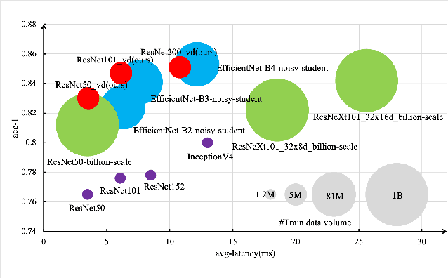
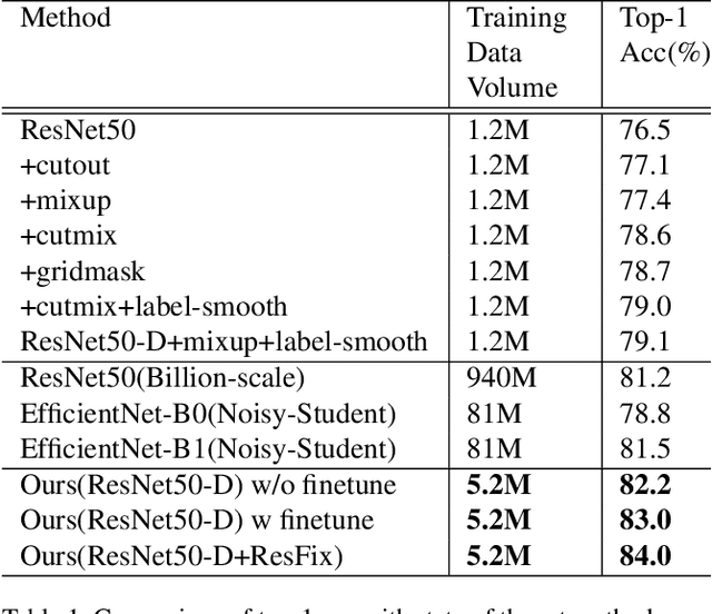
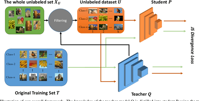
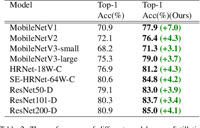
Abstract:Recently, research efforts have been concentrated on revealing how pre-trained model makes a difference in neural network performance. Self-supervision and semi-supervised learning technologies have been extensively explored by the community and are proven to be of great potential in obtaining a powerful pre-trained model. However, these models require huge training costs (i.e., hundreds of millions of images or training iterations). In this paper, we propose to improve existing baseline networks via knowledge distillation from off-the-shelf pre-trained big powerful models. Different from existing knowledge distillation frameworks which require student model to be consistent with both soft-label generated by teacher model and hard-label annotated by humans, our solution performs distillation by only driving prediction of the student model consistent with that of the teacher model. Therefore, our distillation setting can get rid of manually labeled data and can be trained with extra unlabeled data to fully exploit capability of teacher model for better learning. We empirically find that such simple distillation settings perform extremely effective, for example, the top-1 accuracy on ImageNet-1k validation set of MobileNetV3-large and ResNet50-D can be significantly improved from 75.2% to 79% and 79.1% to 83%, respectively. We have also thoroughly analyzed what are dominant factors that affect the distillation performance and how they make a difference. Extensive downstream computer vision tasks, including transfer learning, object detection and semantic segmentation, can significantly benefit from the distilled pretrained models. All our experiments are implemented based on PaddlePaddle, codes and a series of improved pretrained models with ssld suffix are available in PaddleClas.
C-Watcher: A Framework for Early Detection of High-Risk Neighborhoods Ahead of COVID-19 Outbreak
Jan 27, 2021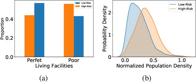

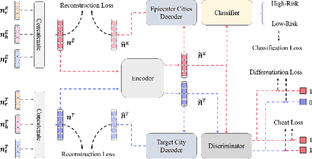
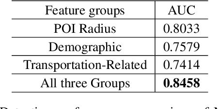
Abstract:The novel coronavirus disease (COVID-19) has crushed daily routines and is still rampaging through the world. Existing solution for nonpharmaceutical interventions usually needs to timely and precisely select a subset of residential urban areas for containment or even quarantine, where the spatial distribution of confirmed cases has been considered as a key criterion for the subset selection. While such containment measure has successfully stopped or slowed down the spread of COVID-19 in some countries, it is criticized for being inefficient or ineffective, as the statistics of confirmed cases are usually time-delayed and coarse-grained. To tackle the issues, we propose C-Watcher, a novel data-driven framework that aims at screening every neighborhood in a target city and predicting infection risks, prior to the spread of COVID-19 from epicenters to the city. In terms of design, C-Watcher collects large-scale long-term human mobility data from Baidu Maps, then characterizes every residential neighborhood in the city using a set of features based on urban mobility patterns. Furthermore, to transfer the firsthand knowledge (witted in epicenters) to the target city before local outbreaks, we adopt a novel adversarial encoder framework to learn "city-invariant" representations from the mobility-related features for precise early detection of high-risk neighborhoods, even before any confirmed cases known, in the target city. We carried out extensive experiments on C-Watcher using the real-data records in the early stage of COVID-19 outbreaks, where the results demonstrate the efficiency and effectiveness of C-Watcher for early detection of high-risk neighborhoods from a large number of cities.
Read, Watch, and Move: Reinforcement Learning for Temporally Grounding Natural Language Descriptions in Videos
Jan 21, 2019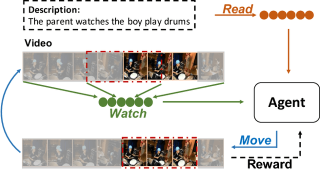
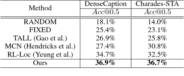
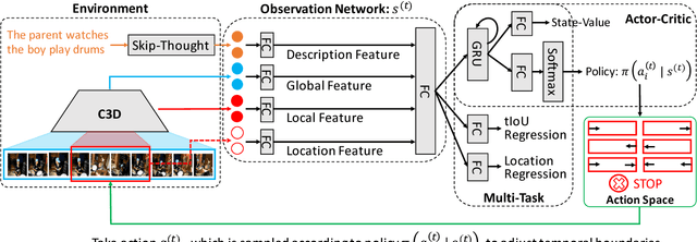
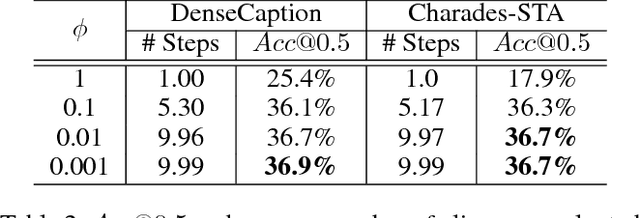
Abstract:The task of video grounding, which temporally localizes a natural language description in a video, plays an important role in understanding videos. Existing studies have adopted strategies of sliding window over the entire video or exhaustively ranking all possible clip-sentence pairs in a pre-segmented video, which inevitably suffer from exhaustively enumerated candidates. To alleviate this problem, we formulate this task as a problem of sequential decision making by learning an agent which regulates the temporal grounding boundaries progressively based on its policy. Specifically, we propose a reinforcement learning based framework improved by multi-task learning and it shows steady performance gains by considering additional supervised boundary information during training. Our proposed framework achieves state-of-the-art performance on ActivityNet'18 DenseCaption dataset and Charades-STA dataset while observing only 10 or less clips per video.
 Add to Chrome
 Add to Firefox
 Add to Edge