 Add to Chrome
 Add to Firefox
 Add to Edge
Prompt-Calibrated SAM 3 for Open-Vocabulary Remote Sensing Semantic Segmentation
Jun 20, 2026Open-vocabulary semantic segmentation (OVSS) in remote sensing images aims to segment categories beyond a fixed label space. Recent SAM 3-based methods provide a promising training-free foundation, yet three key issues remain: (1) a single class-name prompt lacks sufficient semantic coverage for complex remote sensing categories; (2) expanding each category into multiple prompts introduces redundant online text encoding; and (3) directly aggregating multiple prompt responses propagates noisy activations into the final prediction. To address these issues, we propose ProC-SAM3, which calibrates SAM 3's prompt interface for remote sensing OVSS from three complementary aspects. First, we construct an offline prompt pool where a Category Matcher groups MLLM-generated candidates into per-category sets, and Expansion Constraints further refine each set using category-specific prior knowledge. Second, the resulting text embeddings are cached and reused across all test images, eliminating repeated text encoding. Third, we introduce Presence-Guided Residual Fusion to gate unreliable decoder outputs by prompt presence and confidence, followed by peak-preserving class aggregation that retains fine-grained activations for small and sparse objects. Experiments on eight benchmarks show that ProC-SAM3 achieves an average mIoU of 56.1%, outperforming the previous best training-free method by 3.9 percentage points. Code will be available at https://github.com/YanghuiSong/ProC-SAM3.
MuSS: A Large-Scale Dataset and Cinematic Narrative Benchmark for Multi-Shot Subject-to-Video Generation
Apr 26, 2026While video foundation models excel at single-shot generation, real-world cinematic storytelling inherently relies on complex multi-shot sequencing. Further progress is constrained by the absence of datasets that address three core challenges: authentic narrative logic, spatiotemporal text-video alignment conflicts, and the "copy-paste" dilemma prevalent in Subject-to-Video (S2V) generation. To bridge this gap, we introduce MuSS, a large-scale, dual-track dataset tailored for multi-shot video and S2V generation. Sourced from over 3,000 movies, MuSS explicitly supports both complex montage transitions and subject-centric narratives. To construct this dataset, we pioneer a progressive captioning pipeline that eliminates contextual conflicts by ensuring local shot-level accuracy before enforcing global narrative coherence. Crucially, we implement a cross-shot matching mechanism to fundamentally eradicate the S2V copy-paste shortcut. Alongside the dataset, we propose the Cinematic Narrative Benchmark, featuring a visual-logic-driven paradigm and a novel Anti-Copy-Paste Variance (ACP-Var) metric to rigorously assess continuous storytelling and 3D structural consistency. Extensive experiments demonstrate that while current baselines struggle with continuous narrative logic or degenerate into trivial 2D sticker generators, our MuSS-augmented model achieves state-of-the-art narrative effectiveness and cross-shot identity preservation.
Patch-as-Decodable-Token: Towards Unified Multi-Modal Vision Tasks in MLLMs
Oct 02, 2025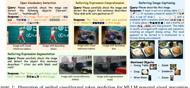
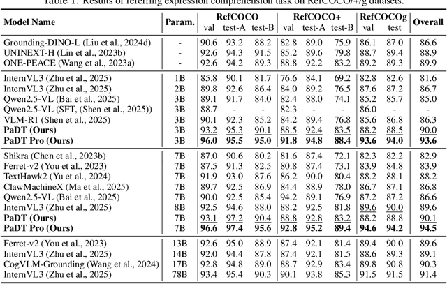
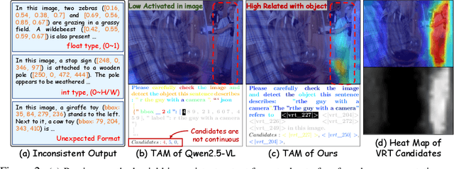
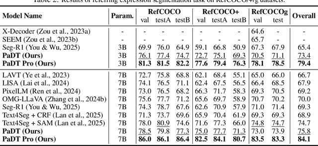
Multimodal large language models (MLLMs) have advanced rapidly in recent years. However, existing approaches for vision tasks often rely on indirect representations, such as generating coordinates as text for detection, which limits performance and prevents dense prediction tasks like segmentation. To overcome these challenges, we introduce Patch-as-Decodable Token (PaDT), a unified paradigm that enables MLLMs to directly generate both textual and diverse visual outputs. Central to PaDT are Visual Reference Tokens (VRTs), derived from visual patch embeddings of query images and interleaved seamlessly with LLM's output textual tokens. A lightweight decoder then transforms LLM's outputs into detection, segmentation, and grounding predictions. Unlike prior methods, PaDT processes VRTs independently at each forward pass and dynamically expands the embedding table, thus improving localization and differentiation among similar objects. We further tailor a training strategy for PaDT by randomly selecting VRTs for supervised fine-tuning and introducing a robust per-token cross-entropy loss. Our empirical studies across four visual perception and understanding tasks suggest PaDT consistently achieving state-of-the-art performance, even compared with significantly larger MLLM models. The code is available at https://github.com/Gorilla-Lab-SCUT/PaDT.
Exploring Generalizable Pre-training for Real-world Change Detection via Geometric Estimation
Apr 19, 2025As an essential procedure in earth observation system, change detection (CD) aims to reveal the spatial-temporal evolution of the observation regions. A key prerequisite for existing change detection algorithms is aligned geo-references between multi-temporal images by fine-grained registration. However, in the majority of real-world scenarios, a prior manual registration is required between the original images, which significantly increases the complexity of the CD workflow. In this paper, we proposed a self-supervision motivated CD framework with geometric estimation, called "MatchCD". Specifically, the proposed MatchCD framework utilizes the zero-shot capability to optimize the encoder with self-supervised contrastive representation, which is reused in the downstream image registration and change detection to simultaneously handle the bi-temporal unalignment and object change issues. Moreover, unlike the conventional change detection requiring segmenting the full-frame image into small patches, our MatchCD framework can directly process the original large-scale image (e.g., 6K*4K resolutions) with promising performance. The performance in multiple complex scenarios with significant geometric distortion demonstrates the effectiveness of our proposed framework.
RCCFormer: A Robust Crowd Counting Network Based on Transformer
Apr 07, 2025


Crowd counting, which is a key computer vision task, has emerged as a fundamental technology in crowd analysis and public safety management. However, challenges such as scale variations and complex backgrounds significantly impact the accuracy of crowd counting. To mitigate these issues, this paper proposes a robust Transformer-based crowd counting network, termed RCCFormer, specifically designed for background suppression and scale awareness. The proposed method incorporates a Multi-level Feature Fusion Module (MFFM), which meticulously integrates features extracted at diverse stages of the backbone architecture. It establishes a strong baseline capable of capturing intricate and comprehensive feature representations, surpassing traditional baselines. Furthermore, the introduced Detail-Embedded Attention Block (DEAB) captures contextual information and local details through global self-attention and local attention along with a learnable manner for efficient fusion. This enhances the model's ability to focus on foreground regions while effectively mitigating background noise interference. Additionally, we develop an Adaptive Scale-Aware Module (ASAM), with our novel Input-dependent Deformable Convolution (IDConv) as its fundamental building block. This module dynamically adapts to changes in head target shapes and scales, significantly improving the network's capability to accommodate large-scale variations. The effectiveness of the proposed method is validated on the ShanghaiTech Part_A and Part_B, NWPU-Crowd, and QNRF datasets. The results demonstrate that our RCCFormer achieves excellent performance across all four datasets, showcasing state-of-the-art outcomes.
On the Adversarial Risk of Test Time Adaptation: An Investigation into Realistic Test-Time Data Poisoning
Oct 07, 2024


Test-time adaptation (TTA) updates the model weights during the inference stage using testing data to enhance generalization. However, this practice exposes TTA to adversarial risks. Existing studies have shown that when TTA is updated with crafted adversarial test samples, also known as test-time poisoned data, the performance on benign samples can deteriorate. Nonetheless, the perceived adversarial risk may be overstated if the poisoned data is generated under overly strong assumptions. In this work, we first review realistic assumptions for test-time data poisoning, including white-box versus grey-box attacks, access to benign data, attack budget, and more. We then propose an effective and realistic attack method that better produces poisoned samples without access to benign samples, and derive an effective in-distribution attack objective. We also design two TTA-aware attack objectives. Our benchmarks of existing attack methods reveal that the TTA methods are more robust than previously believed. In addition, we analyze effective defense strategies to help develop adversarially robust TTA methods.
PS-TTL: Prototype-based Soft-labels and Test-Time Learning for Few-shot Object Detection
Aug 11, 2024In recent years, Few-Shot Object Detection (FSOD) has gained widespread attention and made significant progress due to its ability to build models with a good generalization power using extremely limited annotated data. The fine-tuning based paradigm is currently dominating this field, where detectors are initially pre-trained on base classes with sufficient samples and then fine-tuned on novel ones with few samples, but the scarcity of labeled samples of novel classes greatly interferes precisely fitting their data distribution, thus hampering the performance. To address this issue, we propose a new framework for FSOD, namely Prototype-based Soft-labels and Test-Time Learning (PS-TTL). Specifically, we design a Test-Time Learning (TTL) module that employs a mean-teacher network for self-training to discover novel instances from test data, allowing detectors to learn better representations and classifiers for novel classes. Furthermore, we notice that even though relatively low-confidence pseudo-labels exhibit classification confusion, they still tend to recall foreground. We thus develop a Prototype-based Soft-labels (PS) strategy through assessing similarities between low-confidence pseudo-labels and category prototypes as soft-labels to unleash their potential, which substantially mitigates the constraints posed by few-shot samples. Extensive experiments on both the VOC and COCO benchmarks show that PS-TTL achieves the state-of-the-art, highlighting its effectiveness. The code and model are available at https://github.com/gaoyingjay/PS-TTL.
SSLChange: A Self-supervised Change Detection Framework Based on Domain Adaptation
May 28, 2024


In conventional remote sensing change detection (RS CD) procedures, extensive manual labeling for bi-temporal images is first required to maintain the performance of subsequent fully supervised training. However, pixel-level labeling for CD tasks is very complex and time-consuming. In this paper, we explore a novel self-supervised contrastive framework applicable to the RS CD task, which promotes the model to accurately capture spatial, structural, and semantic information through domain adapter and hierarchical contrastive head. The proposed SSLChange framework accomplishes self-learning only by taking a single-temporal sample and can be flexibly transferred to main-stream CD baselines. With self-supervised contrastive learning, feature representation pre-training can be performed directly based on the original data even without labeling. After a certain amount of labels are subsequently obtained, the pre-trained features will be aligned with the labels for fully supervised fine-tuning. Without introducing any additional data or labels, the performance of downstream baselines will experience a significant enhancement. Experimental results on 2 entire datasets and 6 diluted datasets show that our proposed SSLChange improves the performance and stability of CD baseline in data-limited situations. The code of SSLChange will be released at \url{https://github.com/MarsZhaoYT/SSLChange}
Toward distortion-aware change detection in realistic scenarios
Jan 10, 2024In the conventional change detection (CD) pipeline, two manually registered and labeled remote sensing datasets serve as the input of the model for training and prediction. However, in realistic scenarios, data from different periods or sensors could fail to be aligned as a result of various coordinate systems. Geometric distortion caused by coordinate shifting remains a thorny issue for CD algorithms. In this paper, we propose a reusable self-supervised framework for bitemporal geometric distortion in CD tasks. The whole framework is composed of Pretext Representation Pre-training, Bitemporal Image Alignment, and Down-stream Decoder Fine-Tuning. With only single-stage pre-training, the key components of the framework can be reused for assistance in the bitemporal image alignment, while simultaneously enhancing the performance of the CD decoder. Experimental results in 2 large-scale realistic scenarios demonstrate that our proposed method can alleviate the bitemporal geometric distortion in CD tasks.
CLIP-guided Source-free Object Detection in Aerial Images
Jan 10, 2024


Domain adaptation is crucial in aerial imagery, as the visual representation of these images can significantly vary based on factors such as geographic location, time, and weather conditions. Additionally, high-resolution aerial images often require substantial storage space and may not be readily accessible to the public. To address these challenges, we propose a novel Source-Free Object Detection (SFOD) method. Specifically, our approach is built upon a self-training framework; however, self-training can lead to inaccurate learning in the absence of labeled training data. To address this issue, we further integrate Contrastive Language-Image Pre-training (CLIP) to guide the generation of pseudo-labels, termed CLIP-guided Aggregation. By leveraging CLIP's zero-shot classification capability, we use it to aggregate scores with the original predicted bounding boxes, enabling us to obtain refined scores for the pseudo-labels. To validate the effectiveness of our method, we constructed two new datasets from different domains based on the DIOR dataset, named DIOR-C and DIOR-Cloudy. Experiments demonstrate that our method outperforms other comparative algorithms.