 Add to Chrome
 Add to Firefox
 Add to Edge
Beyond Zooming: Learning Multi-Tool Visual Reasoning for Ultra-High-Resolution Remote Sensing
Jul 28, 2026
Ultra-high-resolution (UHR) remote-sensing (RS) imagery provides fine-grained Earth-observation evidence over city-scale scenes, but poses a fundamental challenge for multimodal large language models (MLLMs): task-relevant evidence is often sparse, local, and spatially dispersed across extremely large visual contexts. A natural solution is to equip MLLMs with zoom-in tools for active local inspection. However, through a pilot study on XLRS-Bench, we find that zoom-in is only partially effective: it resolves easy and medium-level tasks with locally recoverable evidence, but saturates on hard cases requiring global search, multi-region comparison, path planning, or dispersed-evidence reasoning. Motivated by this finding, we move beyond single-tool zoom-in and introduce GeoMTVR, a large-scale Geospatial Multi-Tool Visual Reasoning dataset built from wide-area satellite imagery. GeoMTVR contains 13K UHR VQA samples with interleaved reasoning trajectories, diverse visual tool calls, and returned visual observations, enabling models to learn question decomposition, tool selection, regional inspection, object-level grounding, auxiliary visual reasoning, and cross-tool evidence integration. Beyond supervised fine-tuning, we propose a tool-attention-focused reinforcement learning algorithm that concentrates optimization on critical tool-use decisions, including when to invoke tools, which tool to select, where to apply it, and how to interpret tool outputs. By combining SFT on GeoMTVR with our RL algorithm, we develop GeoLens, a multi-tool visual reasoning MLLM for UHR RS. Experiments show that GeoLens consistently outperforms direct reasoning and single-tool zoom-in baselines, achieving stronger accuracy, better evidence grounding, and more efficient tool-use trajectories.

T-STAR: A Large-Scale Benchmark for Spatio-Temporal Panoptic Scene Graph Generation in Satellite Video
Jul 23, 2026Structured understanding of satellite video is essential for advancing dynamic geospatial scene analysis from low-level perception to high-level cognition. To move beyond object-centric perception, this paper introduces spatio-temporal panoptic scene graph generation (TPSG) in satellite video as a new benchmark task. TPSG aims to generate a structured graph composed of a set of triplets <subject, relationship, object> with explicit temporal spans, thereby describing dynamic geospatial scenes by jointly modeling identity-consistent instance masks and spatio-temporal relationships among panoptic scene elements. However, there is still no dedicated dataset for TPSG in satellite video. Moreover, TPSG in satellite video is intrinsically challenging, as objects are often small and weakly textured, cross-frame association is easily disrupted by occlusion and background clutter, and relationship semantics are highly coupled with spatial structure and temporal evolution. Consequently, TPSG models developed for natural videos are not directly applicable to satellite video. This paper presents T-STAR, a large-scale benchmark dataset for TPSG in satellite video, comprising over 1.1 million instance masks and over 3.8 million spatio-temporal triplets across 39 fine-grained object categories and 70 fine-grained relationship categories. To enable TPSG in satellite video, we propose a unified framework to enhance cross-frame instance consistency and spatio-temporal relationship prediction. Extensive experiments demonstrate the significance of T-STAR and the effectiveness of the proposed framework, establishing a strong benchmark for future research on structured satellite video understanding. The dataset and code are available at https://github.com/linlin-dev/T-STAR.
EO-WM: A Physically Informed World Model for Probabilistic Earth Observation Forecasting
Jun 25, 2026Earth Observation (EO) forecasting aims to predict future Earth surface dynamics from satellite observations under changing meteorological conditions. In this paper, we view this task as a partially observed, weather-driven world modeling problem, in which weather acts as a conditioning signal, while forecasting remains uncertain due to sparse observations and unobserved land-surface states. However, existing methods do not fully capture this setting: deterministic models collapse uncertainty into a single future prediction, while diffusion-based methods typically treat weather variables as undifferentiated conditioning signals, and existing benchmarks focus mainly on reconstruction accuracy rather than whether forecasts respond correctly to changed weather forcing.We introduce EO-WM, a video diffusion transformer for multispectral EO forecasting. EO-WM incorporates a physically informed conditioning framework that represents meteorological forcing through a climatological baseline, weather anomalies, and cumulative physical stress signals. Specifically, it separates baseline and anomaly through distinct conditioning pathways, and accumulates anomalous forcing over time to capture sustained heat and drought stress. To evaluate weather-response behavior beyond standard metrics, we introduce two diagnostic benchmarks: an Extreme Summer Benchmark for severity-aware prediction of vegetation degradation under extreme weather, and a Seasonal Matched-Pair Benchmark for testing response fidelity under changed weather forcing. Experiments show that EO-WM reduces the error in predicted Normalized Difference Vegetation Index (NDVI) decline amplitude by a relative 5.63% and improves directional hit rate by a relative 7.80%, while remaining competitive on standard pixel-level metrics. The benchmarks and model will be made open-source at https://github.com/Luo-Z13/EO-WM.
Urban Socio-Semantic Segmentation with Vision-Language Reasoning
Jan 15, 2026As hubs of human activity, urban surfaces consist of a wealth of semantic entities. Segmenting these various entities from satellite imagery is crucial for a range of downstream applications. Current advanced segmentation models can reliably segment entities defined by physical attributes (e.g., buildings, water bodies) but still struggle with socially defined categories (e.g., schools, parks). In this work, we achieve socio-semantic segmentation by vision-language model reasoning. To facilitate this, we introduce the Urban Socio-Semantic Segmentation dataset named SocioSeg, a new resource comprising satellite imagery, digital maps, and pixel-level labels of social semantic entities organized in a hierarchical structure. Additionally, we propose a novel vision-language reasoning framework called SocioReasoner that simulates the human process of identifying and annotating social semantic entities via cross-modal recognition and multi-stage reasoning. We employ reinforcement learning to optimize this non-differentiable process and elicit the reasoning capabilities of the vision-language model. Experiments demonstrate our approach's gains over state-of-the-art models and strong zero-shot generalization. Our dataset and code are available in https://github.com/AMAP-ML/SocioReasoner.
MapGlue: Multimodal Remote Sensing Image Matching
Mar 20, 2025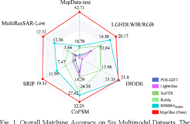
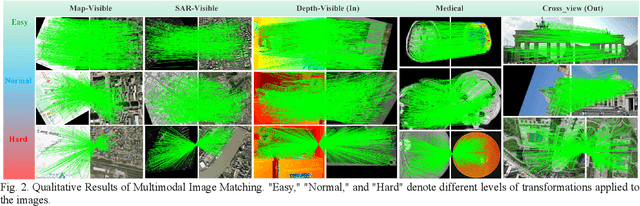
Multimodal remote sensing image (MRSI) matching is pivotal for cross-modal fusion, localization, and object detection, but it faces severe challenges due to geometric, radiometric, and viewpoint discrepancies across imaging modalities. Existing unimodal datasets lack scale and diversity, limiting deep learning solutions. This paper proposes MapGlue, a universal MRSI matching framework, and MapData, a large-scale multimodal dataset addressing these gaps. Our contributions are twofold. MapData, a globally diverse dataset spanning 233 sampling points, offers original images (7,000x5,000 to 20,000x15,000 pixels). After rigorous cleaning, it provides 121,781 aligned electronic map-visible image pairs (512x512 pixels) with hybrid manual-automated ground truth, addressing the scarcity of scalable multimodal benchmarks. MapGlue integrates semantic context with a dual graph-guided mechanism to extract cross-modal invariant features. This structure enables global-to-local interaction, enhancing descriptor robustness against modality-specific distortions. Extensive evaluations on MapData and five public datasets demonstrate MapGlue's superiority in matching accuracy under complex conditions, outperforming state-of-the-art methods. Notably, MapGlue generalizes effectively to unseen modalities without retraining, highlighting its adaptability. This work addresses longstanding challenges in MRSI matching by combining scalable dataset construction with a robust, semantics-driven framework. Furthermore, MapGlue shows strong generalization capabilities on other modality matching tasks for which it was not specifically trained. The dataset and code are available at https://github.com/PeihaoWu/MapGlue.
MEET: A Million-Scale Dataset for Fine-Grained Geospatial Scene Classification with Zoom-Free Remote Sensing Imagery
Mar 14, 2025Accurate fine-grained geospatial scene classification using remote sensing imagery is essential for a wide range of applications. However, existing approaches often rely on manually zooming remote sensing images at different scales to create typical scene samples. This approach fails to adequately support the fixed-resolution image interpretation requirements in real-world scenarios. To address this limitation, we introduce the Million-scale finE-grained geospatial scEne classification dataseT (MEET), which contains over 1.03 million zoom-free remote sensing scene samples, manually annotated into 80 fine-grained categories. In MEET, each scene sample follows a scene-inscene layout, where the central scene serves as the reference, and auxiliary scenes provide crucial spatial context for finegrained classification. Moreover, to tackle the emerging challenge of scene-in-scene classification, we present the Context-Aware Transformer (CAT), a model specifically designed for this task, which adaptively fuses spatial context to accurately classify the scene samples. CAT adaptively fuses spatial context to accurately classify the scene samples by learning attentional features that capture the relationships between the center and auxiliary scenes. Based on MEET, we establish a comprehensive benchmark for fine-grained geospatial scene classification, evaluating CAT against 11 competitive baselines. The results demonstrate that CAT significantly outperforms these baselines, achieving a 1.88% higher balanced accuracy (BA) with the Swin-Large backbone, and a notable 7.87% improvement with the Swin-Huge backbone. Further experiments validate the effectiveness of each module in CAT and show the practical applicability of CAT in the urban functional zone mapping. The source code and dataset will be publicly available at https://jerrywyn.github.io/project/MEET.html.
Towards Privacy-preserved Pre-training of Remote Sensing Foundation Models with Federated Mutual-guidance Learning
Mar 14, 2025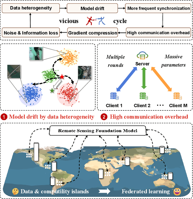
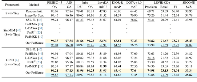
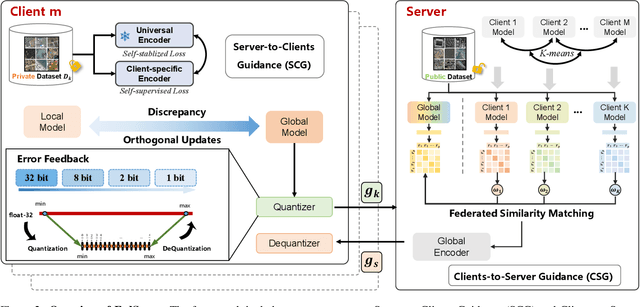
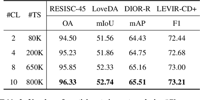
Traditional Remote Sensing Foundation models (RSFMs) are pre-trained with a data-centralized paradigm, through self-supervision on large-scale curated remote sensing data. For each institution, however, pre-training RSFMs with limited data in a standalone manner may lead to suboptimal performance, while aggregating remote sensing data from multiple institutions for centralized pre-training raises privacy concerns. Seeking for collaboration is a promising solution to resolve this dilemma, where multiple institutions can collaboratively train RSFMs without sharing private data. In this paper, we propose a novel privacy-preserved pre-training framework (FedSense), which enables multiple institutions to collaboratively train RSFMs without sharing private data. However, it is a non-trivial task hindered by a vicious cycle, which results from model drift by remote sensing data heterogeneity and high communication overhead. To break this vicious cycle, we introduce Federated Mutual-guidance Learning. Specifically, we propose a Server-to-Clients Guidance (SCG) mechanism to guide clients updates towards global-flatness optimal solutions. Additionally, we propose a Clients-to-Server Guidance (CSG) mechanism to inject local knowledge into the server by low-bit communication. Extensive experiments on four downstream tasks demonstrate the effectiveness of our FedSense in both full-precision and communication-reduced scenarios, showcasing remarkable communication efficiency and performance gains.
When Large Vision-Language Model Meets Large Remote Sensing Imagery: Coarse-to-Fine Text-Guided Token Pruning
Mar 10, 2025Efficient vision-language understanding of large Remote Sensing Images (RSIs) is meaningful but challenging. Current Large Vision-Language Models (LVLMs) typically employ limited pre-defined grids to process images, leading to information loss when handling gigapixel RSIs. Conversely, using unlimited grids significantly increases computational costs. To preserve image details while reducing computational complexity, we propose a text-guided token pruning method with Dynamic Image Pyramid (DIP) integration. Our method introduces: (i) a Region Focus Module (RFM) that leverages text-aware region localization capability to identify critical vision tokens, and (ii) a coarse-to-fine image tile selection and vision token pruning strategy based on DIP, which is guided by RFM outputs and avoids directly processing the entire large imagery. Additionally, existing benchmarks for evaluating LVLMs' perception ability on large RSI suffer from limited question diversity and constrained image sizes. We construct a new benchmark named LRS-VQA, which contains 7,333 QA pairs across 8 categories, with image length up to 27,328 pixels. Our method outperforms existing high-resolution strategies on four datasets using the same data. Moreover, compared to existing token reduction methods, our approach demonstrates higher efficiency under high-resolution settings. Dataset and code are in https://github.com/VisionXLab/LRS-VQA.
Wholly-WOOD: Wholly Leveraging Diversified-quality Labels for Weakly-supervised Oriented Object Detection
Feb 13, 2025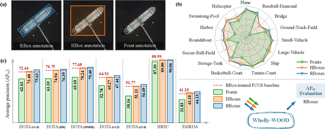
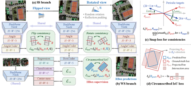
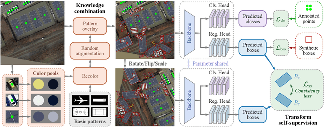
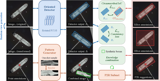
Accurately estimating the orientation of visual objects with compact rotated bounding boxes (RBoxes) has become a prominent demand, which challenges existing object detection paradigms that only use horizontal bounding boxes (HBoxes). To equip the detectors with orientation awareness, supervised regression/classification modules have been introduced at the high cost of rotation annotation. Meanwhile, some existing datasets with oriented objects are already annotated with horizontal boxes or even single points. It becomes attractive yet remains open for effectively utilizing weaker single point and horizontal annotations to train an oriented object detector (OOD). We develop Wholly-WOOD, a weakly-supervised OOD framework, capable of wholly leveraging various labeling forms (Points, HBoxes, RBoxes, and their combination) in a unified fashion. By only using HBox for training, our Wholly-WOOD achieves performance very close to that of the RBox-trained counterpart on remote sensing and other areas, significantly reducing the tedious efforts on labor-intensive annotation for oriented objects. The source codes are available at https://github.com/VisionXLab/whollywood (PyTorch-based) and https://github.com/VisionXLab/whollywood-jittor (Jittor-based).
Multi-Resolution SAR and Optical Remote Sensing Image Registration Methods: A Review, Datasets, and Future Perspectives
Feb 03, 2025


Synthetic Aperture Radar (SAR) and optical image registration is essential for remote sensing data fusion, with applications in military reconnaissance, environmental monitoring, and disaster management. However, challenges arise from differences in imaging mechanisms, geometric distortions, and radiometric properties between SAR and optical images. As image resolution increases, fine SAR textures become more significant, leading to alignment issues and 3D spatial discrepancies. Two major gaps exist: the lack of a publicly available multi-resolution, multi-scene registration dataset and the absence of systematic analysis of current methods. To address this, the MultiResSAR dataset was created, containing over 10k pairs of multi-source, multi-resolution, and multi-scene SAR and optical images. Sixteen state-of-the-art algorithms were tested. Results show no algorithm achieves 100% success, and performance decreases as resolution increases, with most failing on sub-meter data. XoFTR performs best among deep learning methods (40.58%), while RIFT performs best among traditional methods (66.51%). Future research should focus on noise suppression, 3D geometric fusion, cross-view transformation modeling, and deep learning optimization for robust registration of high-resolution SAR and optical images. The dataset is available at https://github.com/betterlll/Multi-Resolution-SAR-dataset-.