 Add to Chrome
 Add to Firefox
 Add to Edge
3D LULC classification using multispectral LiDAR and deep learning: current and prospective schemes
May 21, 2026
Land Use Land Cover (LULC) classification is essential for national 3D mapping, geospatial analysis, and sustainable planning. Multispectral (MS) LiDAR provides synchronized spatial-spectral information, and deep learning (DL) enables 3D point cloud semantic segmentation; however, adoption is limited by the lack of publicly available urban and suburban MS LiDAR datasets aligned with National Mapping and Cadastral Agencies (NMCAs) classification schemes. This study addresses these gaps by introducing L1 and L2 NMCA-aligned LULC classification schemes and a new benchmark MS LiDAR dataset. We evaluate seven state-of-the-art DL models and perform spectral ablation studies at both levels of detail. Results show that Point Transformer V3 achieves the best performance, with mIoU of 79.4% (L1, 8 classes) and 58.9% (L2, 20 classes) using a dual-wavelength LiDAR system (532 nm and 1064 nm). Ablation results show that multispectral information improves performance over geometry-only inputs, with gains of 1.1 percentage points at L1 and 7.8 points at L2. These results highlight the value of LiDAR reflectance for fine-grained material discrimination and support the evolution of NMCA LULC schemes toward higher semantic detail. The Loosdorf-MSL dataset contributes a new benchmark for consistent national and international LULC mapping.

WildLIFT: Lifting monocular drone video to 3D for species-agnostic wildlife monitoring
Apr 27, 2026Monocular RGB cameras mounted on drones are widely used for wildlife monitoring, yet most analytical pipelines remain confined to two-dimensional image space, leaving geometric information in video underexploited. We present WildLIFT, a computational framework that integrates three-dimensional scene geometry from monocular drone video with open-vocabulary 2D instance segmentation to enable species-agnostic 3D detection and tracking. Oriented 3D bounding box labels with semantic face information enable quantitative assessment of viewpoint coverage and inter-animal occlusion, producing structured metadata for downstream ecological analyses. We validate the framework on 2,581 manually curated frames comprising over 6,700 3D detections across four large mammal species. WildLIFT maintains high identity consistency in multi-animal scenes and substantially reduces manual 3D annotation effort through keyframe-based refinement. By transforming standard drone footage into structured 3D and viewpoint-aware representations, WildLIFT extends the analytical utility of aerial wildlife datasets for behavioural research and population monitoring.
Adding Another Dimension to Image-based Animal Detection
Apr 10, 2026Monocular imaging of animals inherently reduces 3D structures to 2D projections. Detection algorithms lead to 2D bounding boxes that lack information about animal's orientation relative to the camera. To build 3D detection methods for RGB animal images, there is a lack of labeled datasets; such labeling processes require 3D input streams along with RGB data. We present a pipeline that utilises Skinned Multi Animal Linear models to estimate 3D bounding boxes and to project them as robust labels into 2D image space using a dedicated camera pose refinement algorithm. To assess which sides of the animal are captured, cuboid face visibility metrics are computed. These 3D bounding boxes and metrics form a crucial step toward developing and benchmarking future monocular 3D animal detection algorithms. We evaluate our method on the Animal3D dataset, demonstrating accurate performance across species and settings.
A-TDOM: Active TDOM via On-the-Fly 3DGS
Sep 16, 2025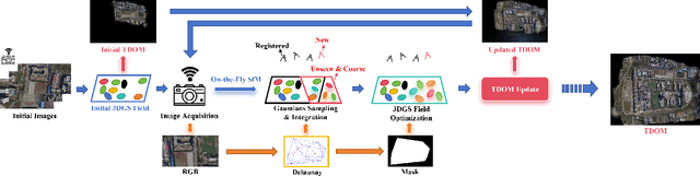
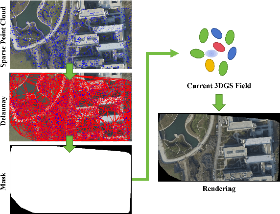
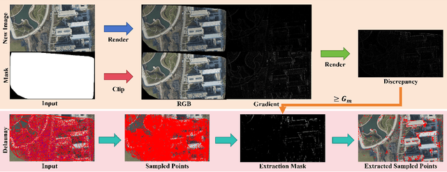
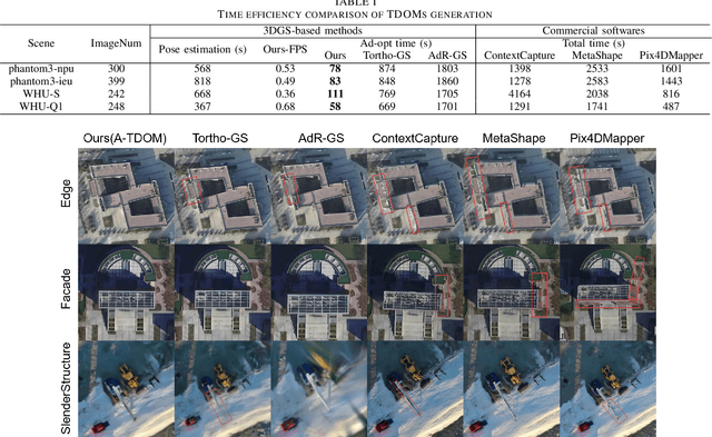
True Digital Orthophoto Map (TDOM) serves as a crucial geospatial product in various fields such as urban management, city planning, land surveying, etc. However, traditional TDOM generation methods generally rely on a complex offline photogrammetric pipeline, resulting in delays that hinder real-time applications. Moreover, the quality of TDOM may degrade due to various challenges, such as inaccurate camera poses or Digital Surface Model (DSM) and scene occlusions. To address these challenges, this work introduces A-TDOM, a near real-time TDOM generation method based on On-the-Fly 3DGS optimization. As each image is acquired, its pose and sparse point cloud are computed via On-the-Fly SfM. Then new Gaussians are integrated and optimized into previously unseen or coarsely reconstructed regions. By integrating with orthogonal splatting, A-TDOM can render just after each update of a new 3DGS field. Initial experiments on multiple benchmarks show that the proposed A-TDOM is capable of actively rendering TDOM in near real-time, with 3DGS optimization for each new image in seconds while maintaining acceptable rendering quality and TDOM geometric accuracy.
Multispectral LiDAR data for extracting tree points in urban and suburban areas
Aug 27, 2025Monitoring urban tree dynamics is vital for supporting greening policies and reducing risks to electrical infrastructure. Airborne laser scanning has advanced large-scale tree management, but challenges remain due to complex urban environments and tree variability. Multispectral (MS) light detection and ranging (LiDAR) improves this by capturing both 3D spatial and spectral data, enabling detailed mapping. This study explores tree point extraction using MS-LiDAR and deep learning (DL) models. Three state-of-the-art models are evaluated: Superpoint Transformer (SPT), Point Transformer V3 (PTv3), and Point Transformer V1 (PTv1). Results show the notable time efficiency and accuracy of SPT, with a mean intersection over union (mIoU) of 85.28%. The highest detection accuracy is achieved by incorporating pseudo normalized difference vegetation index (pNDVI) with spatial data, reducing error rate by 10.61 percentage points (pp) compared to using spatial information alone. These findings highlight the potential of MS-LiDAR and DL to improve tree extraction and further tree inventories.
Multispectral airborne laser scanning for tree species classification: a benchmark of machine learning and deep learning algorithms
Apr 19, 2025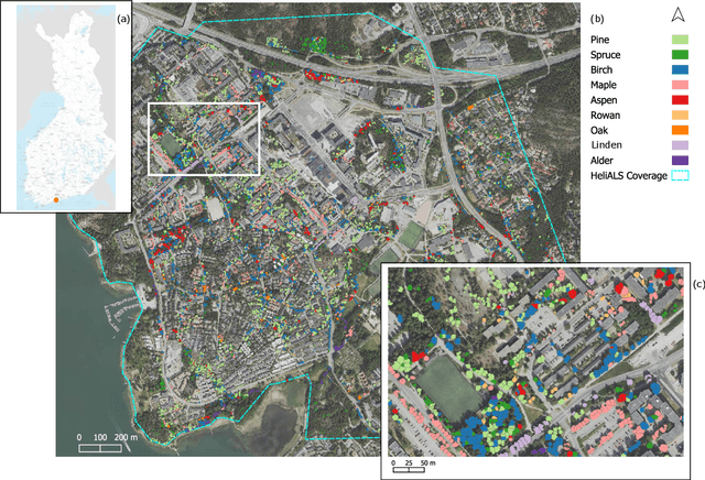
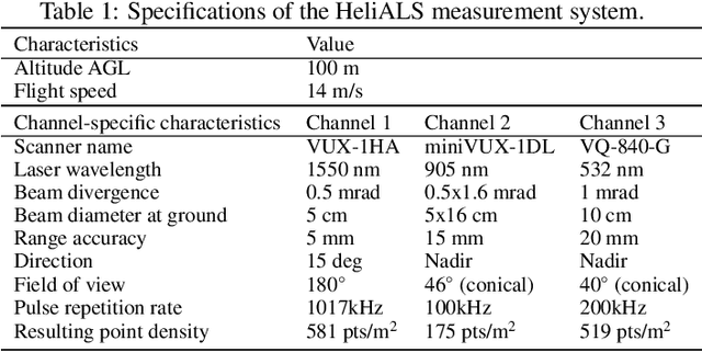
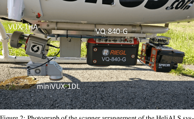
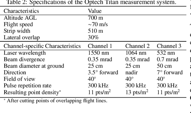
Climate-smart and biodiversity-preserving forestry demands precise information on forest resources, extending to the individual tree level. Multispectral airborne laser scanning (ALS) has shown promise in automated point cloud processing and tree segmentation, but challenges remain in identifying rare tree species and leveraging deep learning techniques. This study addresses these gaps by conducting a comprehensive benchmark of machine learning and deep learning methods for tree species classification. For the study, we collected high-density multispectral ALS data (>1000 pts/m$^2$) at three wavelengths using the FGI-developed HeliALS system, complemented by existing Optech Titan data (35 pts/m$^2$), to evaluate the species classification accuracy of various algorithms in a test site located in Southern Finland. Based on 5261 test segments, our findings demonstrate that point-based deep learning methods, particularly a point transformer model, outperformed traditional machine learning and image-based deep learning approaches on high-density multispectral point clouds. For the high-density ALS dataset, a point transformer model provided the best performance reaching an overall (macro-average) accuracy of 87.9% (74.5%) with a training set of 1065 segments and 92.0% (85.1%) with 5000 training segments. The best image-based deep learning method, DetailView, reached an overall (macro-average) accuracy of 84.3% (63.9%), whereas a random forest (RF) classifier achieved an overall (macro-average) accuracy of 83.2% (61.3%). Importantly, the overall classification accuracy of the point transformer model on the HeliALS data increased from 73.0% with no spectral information to 84.7% with single-channel reflectance, and to 87.9% with spectral information of all the three channels.
3DSceneEditor: Controllable 3D Scene Editing with Gaussian Splatting
Dec 02, 2024


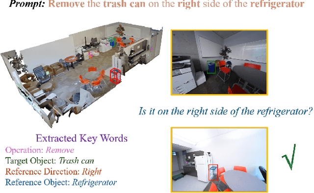
The creation of 3D scenes has traditionally been both labor-intensive and costly, requiring designers to meticulously configure 3D assets and environments. Recent advancements in generative AI, including text-to-3D and image-to-3D methods, have dramatically reduced the complexity and cost of this process. However, current techniques for editing complex 3D scenes continue to rely on generally interactive multi-step, 2D-to-3D projection methods and diffusion-based techniques, which often lack precision in control and hamper real-time performance. In this work, we propose 3DSceneEditor, a fully 3D-based paradigm for real-time, precise editing of intricate 3D scenes using Gaussian Splatting. Unlike conventional methods, 3DSceneEditor operates through a streamlined 3D pipeline, enabling direct manipulation of Gaussians for efficient, high-quality edits based on input prompts.The proposed framework (i) integrates a pre-trained instance segmentation model for semantic labeling; (ii) employs a zero-shot grounding approach with CLIP to align target objects with user prompts; and (iii) applies scene modifications, such as object addition, repositioning, recoloring, replacing, and deletion directly on Gaussians. Extensive experimental results show that 3DSceneEditor achieves superior editing precision and speed with respect to current SOTA 3D scene editing approaches, establishing a new benchmark for efficient and interactive 3D scene customization.
Image Matching Filtering and Refinement by Planes and Beyond
Nov 14, 2024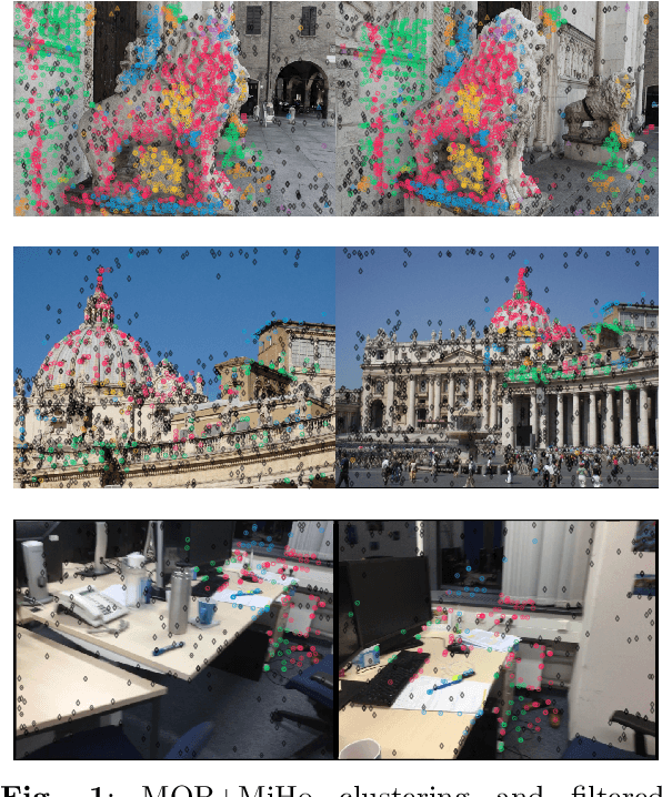


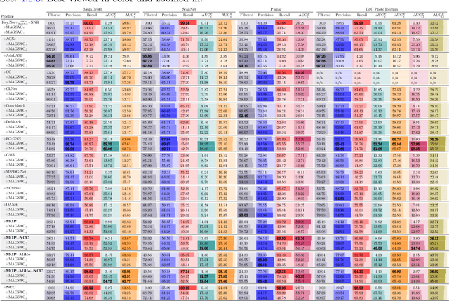
This paper introduces a modular, non-deep learning method for filtering and refining sparse correspondences in image matching. Assuming that motion flow within the scene can be approximated by local homography transformations, matches are aggregated into overlapping clusters corresponding to virtual planes using an iterative RANSAC-based approach, with non-conforming correspondences discarded. Moreover, the underlying planar structural design provides an explicit map between local patches associated with the matches, enabling optional refinement of keypoint positions through cross-correlation template matching after patch reprojection. Finally, to enhance robustness and fault-tolerance against violations of the piece-wise planar approximation assumption, a further strategy is designed for minimizing relative patch distortion in the plane reprojection by introducing an intermediate homography that projects both patches into a common plane. The proposed method is extensively evaluated on standard datasets and image matching pipelines, and compared with state-of-the-art approaches. Unlike other current comparisons, the proposed benchmark also takes into account the more general, real, and practical cases where camera intrinsics are unavailable. Experimental results demonstrate that our proposed non-deep learning, geometry-based approach achieves performances that are either superior to or on par with recent state-of-the-art deep learning methods. Finally, this study suggests that there are still development potential in actual image matching solutions in the considered research direction, which could be in the future incorporated in novel deep image matching architectures.
Exploring the potential of collaborative UAV 3D mapping in Kenyan savanna for wildlife research
Sep 24, 2024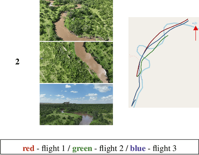
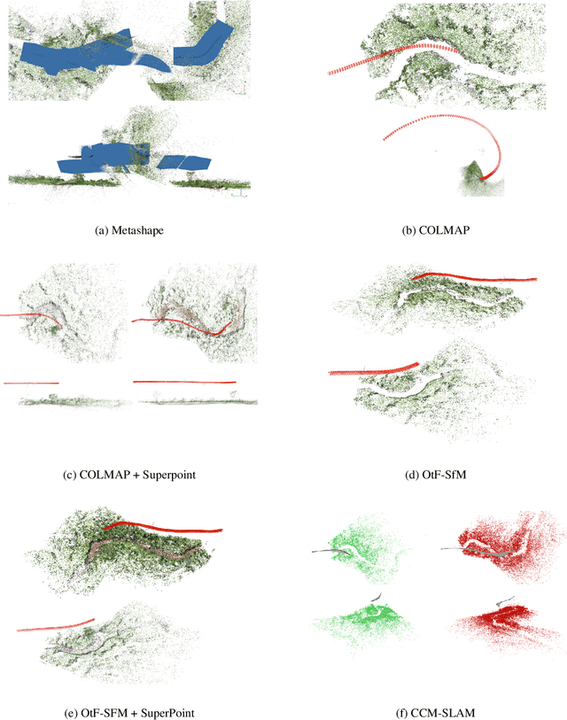
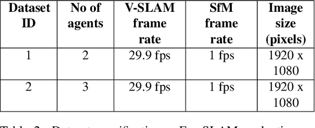
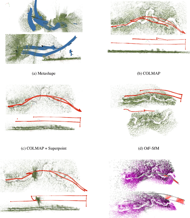
UAV-based biodiversity conservation applications have exhibited many data acquisition advantages for researchers. UAV platforms with embedded data processing hardware can support conservation challenges through 3D habitat mapping, surveillance and monitoring solutions. High-quality real-time scene reconstruction as well as real-time UAV localization can optimize the exploration vs exploitation balance of single or collaborative mission. In this work, we explore the potential of two collaborative frameworks - Visual Simultaneous Localization and Mapping (V-SLAM) and Structure-from-Motion (SfM) for 3D mapping purposes and compare results with standard offline approaches.
RenderWorld: World Model with Self-Supervised 3D Label
Sep 17, 2024



End-to-end autonomous driving with vision-only is not only more cost-effective compared to LiDAR-vision fusion but also more reliable than traditional methods. To achieve a economical and robust purely visual autonomous driving system, we propose RenderWorld, a vision-only end-to-end autonomous driving framework, which generates 3D occupancy labels using a self-supervised gaussian-based Img2Occ Module, then encodes the labels by AM-VAE, and uses world model for forecasting and planning. RenderWorld employs Gaussian Splatting to represent 3D scenes and render 2D images greatly improves segmentation accuracy and reduces GPU memory consumption compared with NeRF-based methods. By applying AM-VAE to encode air and non-air separately, RenderWorld achieves more fine-grained scene element representation, leading to state-of-the-art performance in both 4D occupancy forecasting and motion planning from autoregressive world model.