 Add to Chrome
 Add to Firefox
 Add to Edge
3D LULC classification using multispectral LiDAR and deep learning: current and prospective schemes
May 21, 2026
Land Use Land Cover (LULC) classification is essential for national 3D mapping, geospatial analysis, and sustainable planning. Multispectral (MS) LiDAR provides synchronized spatial-spectral information, and deep learning (DL) enables 3D point cloud semantic segmentation; however, adoption is limited by the lack of publicly available urban and suburban MS LiDAR datasets aligned with National Mapping and Cadastral Agencies (NMCAs) classification schemes. This study addresses these gaps by introducing L1 and L2 NMCA-aligned LULC classification schemes and a new benchmark MS LiDAR dataset. We evaluate seven state-of-the-art DL models and perform spectral ablation studies at both levels of detail. Results show that Point Transformer V3 achieves the best performance, with mIoU of 79.4% (L1, 8 classes) and 58.9% (L2, 20 classes) using a dual-wavelength LiDAR system (532 nm and 1064 nm). Ablation results show that multispectral information improves performance over geometry-only inputs, with gains of 1.1 percentage points at L1 and 7.8 points at L2. These results highlight the value of LiDAR reflectance for fine-grained material discrimination and support the evolution of NMCA LULC schemes toward higher semantic detail. The Loosdorf-MSL dataset contributes a new benchmark for consistent national and international LULC mapping.

Multispectral airborne laser scanning for tree species classification: a benchmark of machine learning and deep learning algorithms
Apr 19, 2025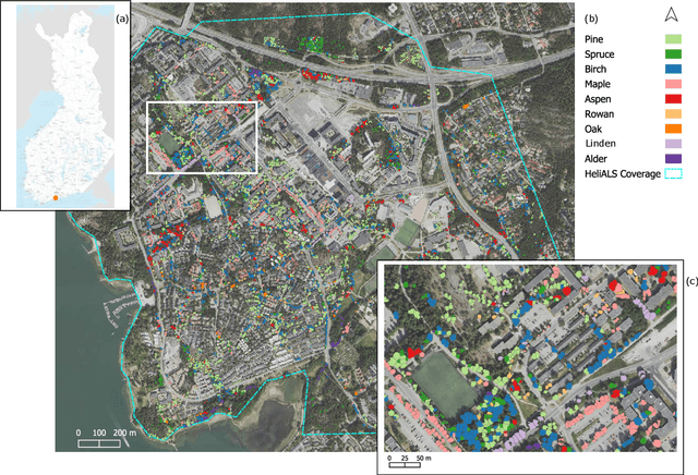
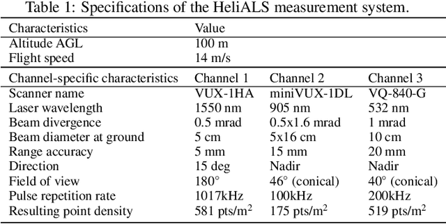
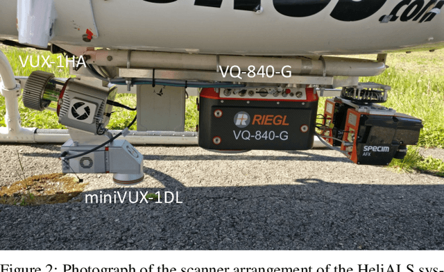
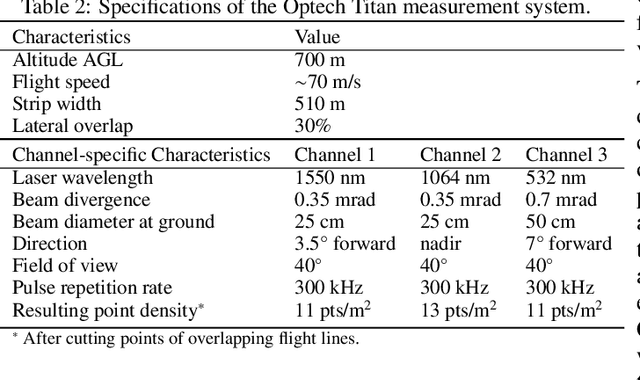
Climate-smart and biodiversity-preserving forestry demands precise information on forest resources, extending to the individual tree level. Multispectral airborne laser scanning (ALS) has shown promise in automated point cloud processing and tree segmentation, but challenges remain in identifying rare tree species and leveraging deep learning techniques. This study addresses these gaps by conducting a comprehensive benchmark of machine learning and deep learning methods for tree species classification. For the study, we collected high-density multispectral ALS data (>1000 pts/m$^2$) at three wavelengths using the FGI-developed HeliALS system, complemented by existing Optech Titan data (35 pts/m$^2$), to evaluate the species classification accuracy of various algorithms in a test site located in Southern Finland. Based on 5261 test segments, our findings demonstrate that point-based deep learning methods, particularly a point transformer model, outperformed traditional machine learning and image-based deep learning approaches on high-density multispectral point clouds. For the high-density ALS dataset, a point transformer model provided the best performance reaching an overall (macro-average) accuracy of 87.9% (74.5%) with a training set of 1065 segments and 92.0% (85.1%) with 5000 training segments. The best image-based deep learning method, DetailView, reached an overall (macro-average) accuracy of 84.3% (63.9%), whereas a random forest (RF) classifier achieved an overall (macro-average) accuracy of 83.2% (61.3%). Importantly, the overall classification accuracy of the point transformer model on the HeliALS data increased from 73.0% with no spectral information to 84.7% with single-channel reflectance, and to 87.9% with spectral information of all the three channels.
FOR-instance: a UAV laser scanning benchmark dataset for semantic and instance segmentation of individual trees
Sep 03, 2023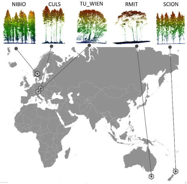
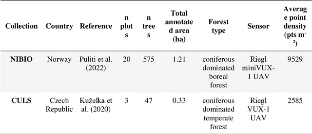
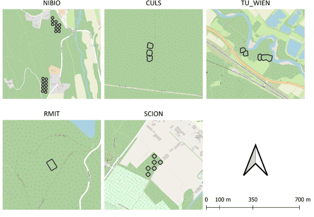
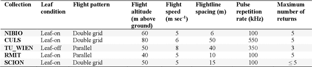
The FOR-instance dataset (available at https://doi.org/10.5281/zenodo.8287792) addresses the challenge of accurate individual tree segmentation from laser scanning data, crucial for understanding forest ecosystems and sustainable management. Despite the growing need for detailed tree data, automating segmentation and tracking scientific progress remains difficult. Existing methodologies often overfit small datasets and lack comparability, limiting their applicability. Amid the progress triggered by the emergence of deep learning methodologies, standardized benchmarking assumes paramount importance in these research domains. This data paper introduces a benchmarking dataset for dense airborne laser scanning data, aimed at advancing instance and semantic segmentation techniques and promoting progress in 3D forest scene segmentation. The FOR-instance dataset comprises five curated and ML-ready UAV-based laser scanning data collections from diverse global locations, representing various forest types. The laser scanning data were manually annotated into individual trees (instances) and different semantic classes (e.g. stem, woody branches, live branches, terrain, low vegetation). The dataset is divided into development and test subsets, enabling method advancement and evaluation, with specific guidelines for utilization. It supports instance and semantic segmentation, offering adaptability to deep learning frameworks and diverse segmentation strategies, while the inclusion of diameter at breast height data expands its utility to the measurement of a classic tree variable. In conclusion, the FOR-instance dataset contributes to filling a gap in the 3D forest research, enhancing the development and benchmarking of segmentation algorithms for dense airborne laser scanning data.