Yun Chang
Language-Grounded Hierarchical Planning and Execution with Multi-Robot 3D Scene Graphs
Jun 09, 2025Abstract:In this paper, we introduce a multi-robot system that integrates mapping, localization, and task and motion planning (TAMP) enabled by 3D scene graphs to execute complex instructions expressed in natural language. Our system builds a shared 3D scene graph incorporating an open-set object-based map, which is leveraged for multi-robot 3D scene graph fusion. This representation supports real-time, view-invariant relocalization (via the object-based map) and planning (via the 3D scene graph), allowing a team of robots to reason about their surroundings and execute complex tasks. Additionally, we introduce a planning approach that translates operator intent into Planning Domain Definition Language (PDDL) goals using a Large Language Model (LLM) by leveraging context from the shared 3D scene graph and robot capabilities. We provide an experimental assessment of the performance of our system on real-world tasks in large-scale, outdoor environments.
An Addendum to NeBula: Towards Extending TEAM CoSTAR's Solution to Larger Scale Environments
Apr 18, 2025Abstract:This paper presents an appendix to the original NeBula autonomy solution developed by the TEAM CoSTAR (Collaborative SubTerranean Autonomous Robots), participating in the DARPA Subterranean Challenge. Specifically, this paper presents extensions to NeBula's hardware, software, and algorithmic components that focus on increasing the range and scale of the exploration environment. From the algorithmic perspective, we discuss the following extensions to the original NeBula framework: (i) large-scale geometric and semantic environment mapping; (ii) an adaptive positioning system; (iii) probabilistic traversability analysis and local planning; (iv) large-scale POMDP-based global motion planning and exploration behavior; (v) large-scale networking and decentralized reasoning; (vi) communication-aware mission planning; and (vii) multi-modal ground-aerial exploration solutions. We demonstrate the application and deployment of the presented systems and solutions in various large-scale underground environments, including limestone mine exploration scenarios as well as deployment in the DARPA Subterranean challenge.
ASHiTA: Automatic Scene-grounded HIerarchical Task Analysis
Apr 10, 2025Abstract:While recent work in scene reconstruction and understanding has made strides in grounding natural language to physical 3D environments, it is still challenging to ground abstract, high-level instructions to a 3D scene. High-level instructions might not explicitly invoke semantic elements in the scene, and even the process of breaking a high-level task into a set of more concrete subtasks, a process called hierarchical task analysis, is environment-dependent. In this work, we propose ASHiTA, the first framework that generates a task hierarchy grounded to a 3D scene graph by breaking down high-level tasks into grounded subtasks. ASHiTA alternates LLM-assisted hierarchical task analysis, to generate the task breakdown, with task-driven 3D scene graph construction to generate a suitable representation of the environment. Our experiments show that ASHiTA performs significantly better than LLM baselines in breaking down high-level tasks into environment-dependent subtasks and is additionally able to achieve grounding performance comparable to state-of-the-art methods.
Clio: Real-time Task-Driven Open-Set 3D Scene Graphs
Apr 29, 2024


Abstract:Modern tools for class-agnostic image segmentation (e.g., SegmentAnything) and open-set semantic understanding (e.g., CLIP) provide unprecedented opportunities for robot perception and mapping. While traditional closed-set metric-semantic maps were restricted to tens or hundreds of semantic classes, we can now build maps with a plethora of objects and countless semantic variations. This leaves us with a fundamental question: what is the right granularity for the objects (and, more generally, for the semantic concepts) the robot has to include in its map representation? While related work implicitly chooses a level of granularity by tuning thresholds for object detection, we argue that such a choice is intrinsically task-dependent. The first contribution of this paper is to propose a task-driven 3D scene understanding problem, where the robot is given a list of tasks in natural language and has to select the granularity and the subset of objects and scene structure to retain in its map that is sufficient to complete the tasks. We show that this problem can be naturally formulated using the Information Bottleneck (IB), an established information-theoretic framework. The second contribution is an algorithm for task-driven 3D scene understanding based on an Agglomerative IB approach, that is able to cluster 3D primitives in the environment into task-relevant objects and regions and executes incrementally. The third contribution is to integrate our task-driven clustering algorithm into a real-time pipeline, named Clio, that constructs a hierarchical 3D scene graph of the environment online using only onboard compute, as the robot explores it. Our final contribution is an extensive experimental campaign showing that Clio not only allows real-time construction of compact open-set 3D scene graphs, but also improves the accuracy of task execution by limiting the map to relevant semantic concepts.
Khronos: A Unified Approach for Spatio-Temporal Metric-Semantic SLAM in Dynamic Environments
Feb 21, 2024


Abstract:Perceiving and understanding highly dynamic and changing environments is a crucial capability for robot autonomy. While large strides have been made towards developing dynamic SLAM approaches that estimate the robot pose accurately, a lesser emphasis has been put on the construction of dense spatio-temporal representations of the robot environment. A detailed understanding of the scene and its evolution through time is crucial for long-term robot autonomy and essential to tasks that require long-term reasoning, such as operating effectively in environments shared with humans and other agents and thus are subject to short and long-term dynamics. To address this challenge, this work defines the Spatio-temporal Metric-semantic SLAM (SMS) problem, and presents a framework to factorize and solve it efficiently. We show that the proposed factorization suggests a natural organization of a spatio-temporal perception system, where a fast process tracks short-term dynamics in an active temporal window, while a slower process reasons over long-term changes in the environment using a factor graph formulation. We provide an efficient implementation of the proposed spatio-temporal perception approach, that we call Khronos, and show that it unifies exiting interpretations of short-term and long-term dynamics and is able to construct a dense spatio-temporal map in real-time. We provide simulated and real results, showing that the spatio-temporal maps built by Khronos are an accurate reflection of a 3D scene over time and that Khronos outperforms baselines across multiple metrics. We further validate our approach on two heterogeneous robots in challenging, large-scale real-world environments.
Kimera2: Robust and Accurate Metric-Semantic SLAM in the Real World
Jan 12, 2024Abstract:We present improvements to Kimera, an open-source metric-semantic visual-inertial SLAM library. In particular, we enhance Kimera-VIO, the visual-inertial odometry pipeline powering Kimera, to support better feature tracking, more efficient keyframe selection, and various input modalities (eg monocular, stereo, and RGB-D images, as well as wheel odometry). Additionally, Kimera-RPGO and Kimera-PGMO, Kimera's pose-graph optimization backends, are updated to support modern outlier rejection methods - specifically, Graduated-Non-Convexity - for improved robustness to spurious loop closures. These new features are evaluated extensively on a variety of simulated and real robotic platforms, including drones, quadrupeds, wheeled robots, and simulated self-driving cars. We present comparisons against several state-of-the-art visual-inertial SLAM pipelines and discuss strengths and weaknesses of the new release of Kimera. The newly added features have been released open-source at https://github.com/MIT-SPARK/Kimera.
Foundations of Spatial Perception for Robotics: Hierarchical Representations and Real-time Systems
May 11, 2023Abstract:3D spatial perception is the problem of building and maintaining an actionable and persistent representation of the environment in real-time using sensor data and prior knowledge. Despite the fast-paced progress in robot perception, most existing methods either build purely geometric maps (as in traditional SLAM) or flat metric-semantic maps that do not scale to large environments or large dictionaries of semantic labels. The first part of this paper is concerned with representations: we show that scalable representations for spatial perception need to be hierarchical in nature. Hierarchical representations are efficient to store, and lead to layered graphs with small treewidth, which enable provably efficient inference. We then introduce an example of hierarchical representation for indoor environments, namely a 3D scene graph, and discuss its structure and properties. The second part of the paper focuses on algorithms to incrementally construct a 3D scene graph as the robot explores the environment. Our algorithms combine 3D geometry, topology (to cluster the places into rooms), and geometric deep learning (e.g., to classify the type of rooms the robot is moving across). The third part of the paper focuses on algorithms to maintain and correct 3D scene graphs during long-term operation. We propose hierarchical descriptors for loop closure detection and describe how to correct a scene graph in response to loop closures, by solving a 3D scene graph optimization problem. We conclude the paper by combining the proposed perception algorithms into Hydra, a real-time spatial perception system that builds a 3D scene graph from visual-inertial data in real-time. We showcase Hydra's performance in photo-realistic simulations and real data collected by a Clearpath Jackal robots and a Unitree A1 robot. We release an open-source implementation of Hydra at https://github.com/MIT-SPARK/Hydra.
Hydra-Multi: Collaborative Online Construction of 3D Scene Graphs with Multi-Robot Teams
Apr 26, 2023Abstract:3D scene graphs have recently emerged as an expressive high-level map representation that describes a 3D environment as a layered graph where nodes represent spatial concepts at multiple levels of abstraction (e.g., objects, rooms, buildings) and edges represent relations between concepts (e.g., inclusion, adjacency). This paper describes Hydra-Multi, the first multi-robot spatial perception system capable of constructing a multi-robot 3D scene graph online from sensor data collected by robots in a team. In particular, we develop a centralized system capable of constructing a joint 3D scene graph by taking incremental inputs from multiple robots, effectively finding the relative transforms between the robots' frames, and incorporating loop closure detections to correctly reconcile the scene graph nodes from different robots. We evaluate Hydra-Multi on simulated and real scenarios and show it is able to reconstruct accurate 3D scene graphs online. We also demonstrate Hydra-Multi's capability of supporting heterogeneous teams by fusing different map representations built by robots with different sensor suites.
Resilient and Distributed Multi-Robot Visual SLAM: Datasets, Experiments, and Lessons Learned
Apr 10, 2023


Abstract:This paper revisits Kimera-Multi, a distributed multi-robot Simultaneous Localization and Mapping (SLAM) system, towards the goal of deployment in the real world. In particular, this paper has three main contributions. First, we describe improvements to Kimera-Multi to make it resilient to large-scale real-world deployments, with particular emphasis on handling intermittent and unreliable communication. Second, we collect and release challenging multi-robot benchmarking datasets obtained during live experiments conducted on the MIT campus, with accurate reference trajectories and maps for evaluation. The datasets include up to 8 robots traversing long distances (up to 8 km) and feature many challenging elements such as severe visual ambiguities (e.g., in underground tunnels and hallways), mixed indoor and outdoor trajectories with different lighting conditions, and dynamic entities (e.g., pedestrians and cars). Lastly, we evaluate the resilience of Kimera-Multi under different communication scenarios, and provide a quantitative comparison with a centralized baseline system. Based on the results from both live experiments and subsequent analysis, we discuss the strengths and weaknesses of Kimera-Multi, and suggest future directions for both algorithm and system design. We release the source code of Kimera-Multi and all datasets to facilitate further research towards the reliable real-world deployment of multi-robot SLAM systems.
D-Lite: Navigation-Oriented Compression of 3D Scene Graphs under Communication Constraints
Sep 21, 2022


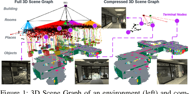
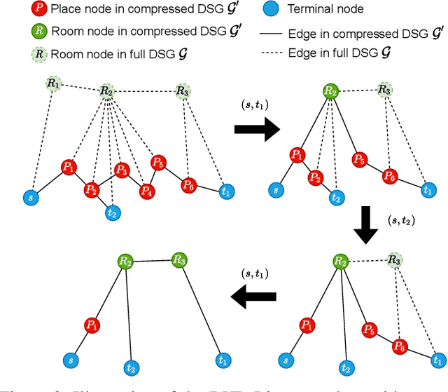
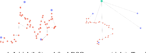
Abstract:For a multi-robot team that collaboratively explores an unknown environment, it is of vital importance that collected information is efficiently shared among robots in order to support exploration and navigation tasks. Practical constraints of wireless channels, such as limited bandwidth and bit-rate, urge robots to carefully select information to be transmitted. In this paper, we consider the case where environmental information is modeled using a 3D Scene Graph, a hierarchical map representation that describes geometric and semantic aspects of the environment. Then, we leverage graph-theoretic tools, namely graph spanners, to design heuristic strategies that efficiently compress 3D Scene Graphs to enable communication under bandwidth constraints. Our compression strategies are navigation-oriented in that they are designed to approximately preserve shortest paths between locations of interest, while meeting a user-specified communication budget constraint. Effectiveness of the proposed algorithms is demonstrated via extensive numerical analysis and on synthetic robot navigation experiments in a realistic simulator. A video abstract is available at https://youtu.be/nKYXU5VC6A8.
 Add to Chrome
 Add to Firefox
 Add to Edge