 Add to Chrome
 Add to Firefox
 Add to Edge
PMMC: Prospective Multimodal Memory Compilation for Long-Term LVLM Agents
Aug 02, 2026
Long-term memory is essential for LVLM agents to maintain consistency and integrate information across extended multimodal interactions. Existing agent memory systems, however, often reduce visual experiences into textual summaries or rely on static retrieve-then-reason pipelines, which are inefficient at query time and brittle when questions require image-text binding, temporal updates, or visual details. We propose Prospective Multimodal Memory Compilation, a framework that shifts part of the memory reasoning process from query time to memory consolidation time. Given accumulated multimodal interactions, a Questioner predicts future question candidates, a Planner compiles question-conditioned multimodal memory programs, and a Doubter verifies whether the planned evidence path can support the predicted answer. The verified question-program pairs form a structured question bank for efficient query-time routing and evidence retrieval. Experiments on multimodal long-term memory benchmarks show that our method improves answer quality and visual evidence recall while reducing query-time token and latency costs. Extensive ablations analyze the effects of self-feedback, dynamic planning, raw-image access, and question bank coverage.

GeoChrono: Benchmarking and Rethinking Long-Term Temporal Understanding in Remote Sensing
Jul 17, 2026Remote sensing offers an unparalleled vantage point for observing the Earth's long-term surface evolution, yet it demands that a model not only perceive land cover at isolated moments, but also track changes, memorize evolution histories, and reason across time and space. However, existing studies lack a systematic evaluation that dissects these distinct competencies. To fill this gap, we introduce ChronoBench, a multidimensional benchmark that decomposes this task into four progressive cognitive levels (i.e., Land Cover Perception, Temporal Recognition, Long-Term Memory, and Spatio-Temporal Reasoning). The ChronoBench comprises 12 sub-tasks and 17,689 rigorously validated QA (Question-Answer) pairs. Extensive evaluations reveal that mainstream MLLMs fall drastically behind human experts, with Long-Term Memory emerging as the most critical bottleneck. Motivated by this finding, we further propose GeoChrono, an MLLM with enhanced capabilities for tracing, memorizing, and reasoning about long-term geographic evolution. Leveraging the physical prior that geographic parcels remain spatially fixed while their semantics evolve, we design a Temporal Trajectory Encoder~(TempEnc) that constructs per-location temporal trajectories for dedicated land cover evolution modeling, and we introduce a Coarse-to-Fine Token Compressor~(C2FComp) that adaptively preserves dynamic regions while compressing the static background. To support training, we also construct ChronoInstruct, a 104K-sample instruction-tuning dataset spanning all competency levels for training. GeoChrono achieves state-of-the-art performance on ChronoBench, surpassing the leading commercial MLLMs by over 20%, while C2FComp reduces visual tokens by over 56% while retaining GeoChrono's 94.6% performance. The code and data will be available at https://github.com/IntelliSensing/GeoChrono
Self in Space: Benchmarking Self-Awareness and Spatial Cognition in UAV Embodied Intelligence
Jul 14, 2026Autonomous UAV systems increasingly rely on multimodal large language models (MLLMs) to operate in complex real-world environments. Such embodied scenarios require not only understanding the surrounding space but also maintaining a coherent representation of the agent itself. However, existing UAV-oriented approaches and benchmarks remain largely environment-centric, primarily focusing on spatial understanding tasks, with the agent's self-awareness remaining implicit. To address this gap, we introduce SIS-Bench, a benchmark for evaluating embodied spatial intelligence in UAV scenarios under a unified self-in-space formulation. SIS-Bench organizes evaluation along two complementary dimensions, space and self, and a three-level hierarchy of perception, memory, and reasoning. It contains 4,856 question--answer pairs across 13 tasks derived from 1,646 real-world UAV videos through a task-conditioned construction pipeline with expert verification.Extensive evaluations reveal that current MLLMs exhibit fundamental limitations in modeling dynamic and agent-centered processes. In particular, we observe a clear imbalance between spatial cognition and self-awareness, as well as a progressive performance degradation across cognitive levels.Motivated by these findings, we further explore a motion-aware representation that incorporates self-related dynamics through optical flow and visual feature fusion. Experimental results show that modeling agent motion consistently improves perception and memory performance, not only in spatial cognition but also in self-awareness, and generalizes to downstream UAV decision-making tasks.Our results highlight the importance of self-awareness for advancing embodied spatial intelligence, and provide both a new benchmark and empirical evidence for motion-aware self-in-space modeling.
The Second Challenge on Cross-Domain Few-Shot Object Detection at NTIRE 2026: Methods and Results
Apr 13, 2026Cross-domain few-shot object detection (CD-FSOD) remains a challenging problem for existing object detectors and few-shot learning approaches, particularly when generalizing across distinct domains. As part of NTIRE 2026, we hosted the second CD-FSOD Challenge to systematically evaluate and promote progress in detecting objects in unseen target domains under limited annotation conditions. The challenge received strong community interest, with 128 registered participants and a total of 696 submissions. Among them, 31 teams actively participated, and 19 teams submitted valid final results. Participants explored a wide range of strategies, introducing innovative methods that push the performance frontier under both open-source and closed-source tracks. This report presents a detailed overview of the NTIRE 2026 CD-FSOD Challenge, including a summary of the submitted approaches and an analysis of the final results across all participating teams. Challenge Codes: https://github.com/ohMargin/NTIRE2026_CDFSOD.
Control Copy-Paste: Controllable Diffusion-Based Augmentation Method for Remote Sensing Few-Shot Object Detection
Jul 29, 2025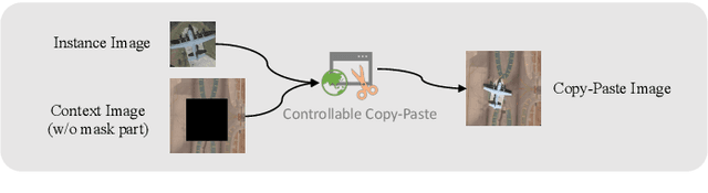
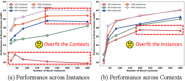
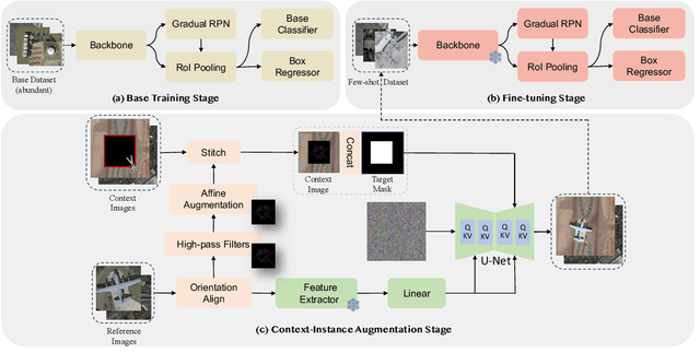
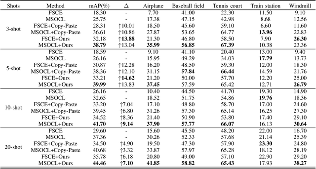
Few-shot object detection (FSOD) for optical remote sensing images aims to detect rare objects with only a few annotated bounding boxes. The limited training data makes it difficult to represent the data distribution of realistic remote sensing scenes, which results in the notorious overfitting problem. Current researchers have begun to enhance the diversity of few-shot novel instances by leveraging diffusion models to solve the overfitting problem. However, naively increasing the diversity of objects is insufficient, as surrounding contexts also play a crucial role in object detection, and in cases where the object diversity is sufficient, the detector tends to overfit to monotonous contexts. Accordingly, we propose Control Copy-Paste, a controllable diffusion-based method to enhance the performance of FSOD by leveraging diverse contextual information. Specifically, we seamlessly inject a few-shot novel objects into images with diverse contexts by a conditional diffusion model. We also develop an orientation alignment strategy to mitigate the integration distortion caused by varying aspect ratios of instances. Experiments on the public DIOR dataset demonstrate that our method can improve detection performance by an average of 10.76%.
EarthSynth: Generating Informative Earth Observation with Diffusion Models
May 17, 2025Remote sensing image (RSI) interpretation typically faces challenges due to the scarcity of labeled data, which limits the performance of RSI interpretation tasks. To tackle this challenge, we propose EarthSynth, a diffusion-based generative foundation model that enables synthesizing multi-category, cross-satellite labeled Earth observation for downstream RSI interpretation tasks. To the best of our knowledge, EarthSynth is the first to explore multi-task generation for remote sensing. EarthSynth, trained on the EarthSynth-180K dataset, employs the Counterfactual Composition training strategy to improve training data diversity and enhance category control. Furthermore, a rule-based method of R-Filter is proposed to filter more informative synthetic data for downstream tasks. We evaluate our EarthSynth on scene classification, object detection, and semantic segmentation in open-world scenarios, offering a practical solution for advancing RSI interpretation.
NTIRE 2025 Challenge on Cross-Domain Few-Shot Object Detection: Methods and Results
Apr 14, 2025Cross-Domain Few-Shot Object Detection (CD-FSOD) poses significant challenges to existing object detection and few-shot detection models when applied across domains. In conjunction with NTIRE 2025, we organized the 1st CD-FSOD Challenge, aiming to advance the performance of current object detectors on entirely novel target domains with only limited labeled data. The challenge attracted 152 registered participants, received submissions from 42 teams, and concluded with 13 teams making valid final submissions. Participants approached the task from diverse perspectives, proposing novel models that achieved new state-of-the-art (SOTA) results under both open-source and closed-source settings. In this report, we present an overview of the 1st NTIRE 2025 CD-FSOD Challenge, highlighting the proposed solutions and summarizing the results submitted by the participants.
Enhance Then Search: An Augmentation-Search Strategy with Foundation Models for Cross-Domain Few-Shot Object Detection
Apr 06, 2025Foundation models pretrained on extensive datasets, such as GroundingDINO and LAE-DINO, have performed remarkably in the cross-domain few-shot object detection (CD-FSOD) task. Through rigorous few-shot training, we found that the integration of image-based data augmentation techniques and grid-based sub-domain search strategy significantly enhances the performance of these foundation models. Building upon GroundingDINO, we employed several widely used image augmentation methods and established optimization objectives to effectively navigate the expansive domain space in search of optimal sub-domains. This approach facilitates efficient few-shot object detection and introduces an approach to solving the CD-FSOD problem by efficiently searching for the optimal parameter configuration from the foundation model. Our findings substantially advance the practical deployment of vision-language models in data-scarce environments, offering critical insights into optimizing their cross-domain generalization capabilities without labor-intensive retraining. Code is available at https://github.com/jaychempan/ETS.
Locate Anything on Earth: Advancing Open-Vocabulary Object Detection for Remote Sensing Community
Aug 17, 2024Object detection, particularly open-vocabulary object detection, plays a crucial role in Earth sciences, such as environmental monitoring, natural disaster assessment, and land-use planning. However, existing open-vocabulary detectors, primarily trained on natural-world images, struggle to generalize to remote sensing images due to a significant data domain gap. Thus, this paper aims to advance the development of open-vocabulary object detection in remote sensing community. To achieve this, we first reformulate the task as Locate Anything on Earth (LAE) with the goal of detecting any novel concepts on Earth. We then developed the LAE-Label Engine which collects, auto-annotates, and unifies up to 10 remote sensing datasets creating the LAE-1M - the first large-scale remote sensing object detection dataset with broad category coverage. Using the LAE-1M, we further propose and train the novel LAE-DINO Model, the first open-vocabulary foundation object detector for the LAE task, featuring Dynamic Vocabulary Construction (DVC) and Visual-Guided Text Prompt Learning (VisGT) modules. DVC dynamically constructs vocabulary for each training batch, while VisGT maps visual features to semantic space, enhancing text features. We comprehensively conduct experiments on established remote sensing benchmark DIOR, DOTAv2.0, as well as our newly introduced 80-class LAE-80C benchmark. Results demonstrate the advantages of the LAE-1M dataset and the effectiveness of the LAE-DINO method.
PIR: Remote Sensing Image-Text Retrieval with Prior Instruction Representation Learning
May 16, 2024Remote sensing image-text retrieval constitutes a foundational aspect of remote sensing interpretation tasks, facilitating the alignment of vision and language representations. This paper introduces a prior instruction representation (PIR) learning paradigm that draws on prior knowledge to instruct adaptive learning of vision and text representations. Based on PIR, a domain-adapted remote sensing image-text retrieval framework PIR-ITR is designed to address semantic noise issues in vision-language understanding tasks. However, with massive additional data for pre-training the vision-language foundation model, remote sensing image-text retrieval is further developed into an open-domain retrieval task. Continuing with the above, we propose PIR-CLIP, a domain-specific CLIP-based framework for remote sensing image-text retrieval, to address semantic noise in remote sensing vision-language representations and further improve open-domain retrieval performance. In vision representation, Vision Instruction Representation (VIR) based on Spatial-PAE utilizes the prior-guided knowledge of the remote sensing scene recognition by building a belief matrix to select key features for reducing the impact of semantic noise. In text representation, Language Cycle Attention (LCA) based on Temporal-PAE uses the previous time step to cyclically activate the current time step to enhance text representation capability. A cluster-wise Affiliation Loss (AL) is proposed to constrain the inter-classes and to reduce the semantic confusion zones in the common subspace. Comprehensive experiments demonstrate that PIR could enhance vision and text representations and outperform the state-of-the-art methods of closed-domain and open-domain retrieval on two benchmark datasets, RSICD and RSITMD.