 Add to Chrome
 Add to Firefox
 Add to Edge
Latent-Space Autoregressive World Model for Efficient and Robust Image-Goal Navigation
Nov 14, 2025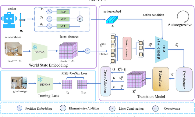
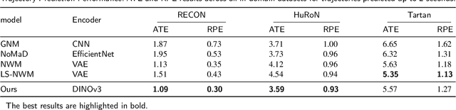
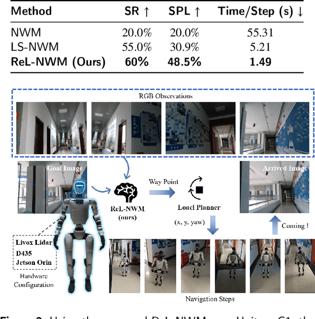
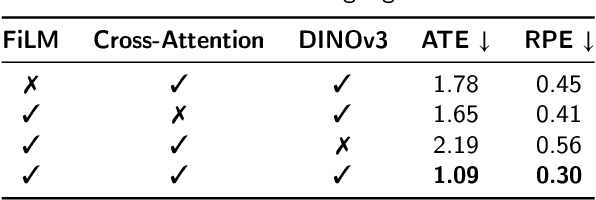
Traditional navigation methods rely heavily on accurate localization and mapping. In contrast, world models that capture environmental dynamics in latent space have opened up new perspectives for navigation tasks, enabling systems to move beyond traditional multi-module pipelines. However, world model often suffers from high computational costs in both training and inference. To address this, we propose LS-NWM - a lightweight latent space navigation world model that is trained and operates entirely in latent space, compared to the state-of-the-art baseline, our method reduces training time by approximately 3.2x and planning time by about 447x,while further improving navigation performance with a 35% higher SR and an 11% higher SPL. The key idea is that accurate pixel-wise environmental prediction is unnecessary for navigation. Instead, the model predicts future latent states based on current observational features and action inputs, then performs path planning and decision-making within this compact representation, significantly improving computational efficiency. By incorporating an autoregressive multi-frame prediction strategy during training, the model effectively captures long-term spatiotemporal dependencies, thereby enhancing navigation performance in complex scenarios. Experimental results demonstrate that our method achieves state-of-the-art navigation performance while maintaining a substantial efficiency advantage over existing approaches.
Dual-Arm Hierarchical Planning for Laboratory Automation: Vibratory Sieve Shaker Operations
Sep 18, 2025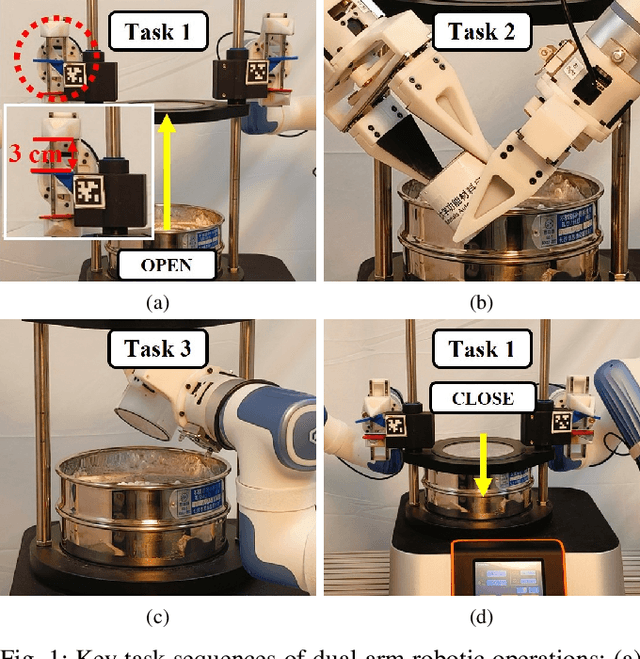
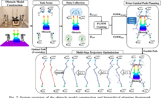
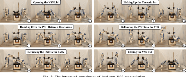
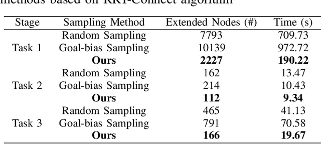
This paper addresses the challenges of automating vibratory sieve shaker operations in a materials laboratory, focusing on three critical tasks: 1) dual-arm lid manipulation in 3 cm clearance spaces, 2) bimanual handover in overlapping workspaces, and 3) obstructed powder sample container delivery with orientation constraints. These tasks present significant challenges, including inefficient sampling in narrow passages, the need for smooth trajectories to prevent spillage, and suboptimal paths generated by conventional methods. To overcome these challenges, we propose a hierarchical planning framework combining Prior-Guided Path Planning and Multi-Step Trajectory Optimization. The former uses a finite Gaussian mixture model to improve sampling efficiency in narrow passages, while the latter refines paths by shortening, simplifying, imposing joint constraints, and B-spline smoothing. Experimental results demonstrate the framework's effectiveness: planning time is reduced by up to 80.4%, and waypoints are decreased by 89.4%. Furthermore, the system completes the full vibratory sieve shaker operation workflow in a physical experiment, validating its practical applicability for complex laboratory automation.
Grasp Like Humans: Learning Generalizable Multi-Fingered Grasping from Human Proprioceptive Sensorimotor Integration
Sep 10, 2025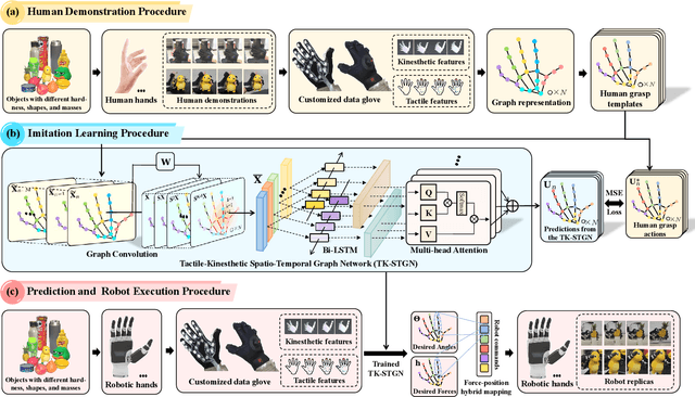
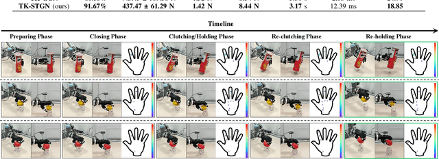
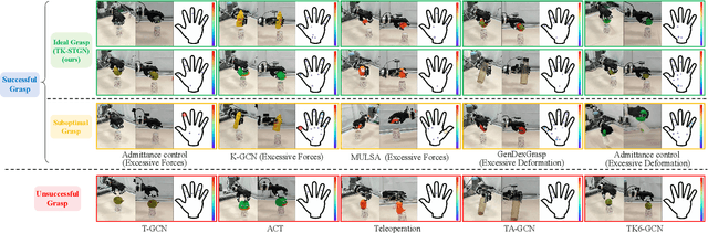
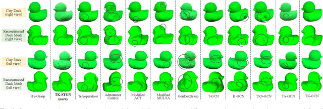
Tactile and kinesthetic perceptions are crucial for human dexterous manipulation, enabling reliable grasping of objects via proprioceptive sensorimotor integration. For robotic hands, even though acquiring such tactile and kinesthetic feedback is feasible, establishing a direct mapping from this sensory feedback to motor actions remains challenging. In this paper, we propose a novel glove-mediated tactile-kinematic perception-prediction framework for grasp skill transfer from human intuitive and natural operation to robotic execution based on imitation learning, and its effectiveness is validated through generalized grasping tasks, including those involving deformable objects. Firstly, we integrate a data glove to capture tactile and kinesthetic data at the joint level. The glove is adaptable for both human and robotic hands, allowing data collection from natural human hand demonstrations across different scenarios. It ensures consistency in the raw data format, enabling evaluation of grasping for both human and robotic hands. Secondly, we establish a unified representation of multi-modal inputs based on graph structures with polar coordinates. We explicitly integrate the morphological differences into the designed representation, enhancing the compatibility across different demonstrators and robotic hands. Furthermore, we introduce the Tactile-Kinesthetic Spatio-Temporal Graph Networks (TK-STGN), which leverage multidimensional subgraph convolutions and attention-based LSTM layers to extract spatio-temporal features from graph inputs to predict node-based states for each hand joint. These predictions are then mapped to final commands through a force-position hybrid mapping.
Probabilistic Temporal Masked Attention for Cross-view Online Action Detection
Aug 23, 2025


As a critical task in video sequence classification within computer vision, Online Action Detection (OAD) has garnered significant attention. The sensitivity of mainstream OAD models to varying video viewpoints often hampers their generalization when confronted with unseen sources. To address this limitation, we propose a novel Probabilistic Temporal Masked Attention (PTMA) model, which leverages probabilistic modeling to derive latent compressed representations of video frames in a cross-view setting. The PTMA model incorporates a GRU-based temporal masked attention (TMA) cell, which leverages these representations to effectively query the input video sequence, thereby enhancing information interaction and facilitating autoregressive frame-level video analysis. Additionally, multi-view information can be integrated into the probabilistic modeling to facilitate the extraction of view-invariant features. Experiments conducted under three evaluation protocols: cross-subject (cs), cross-view (cv), and cross-subject-view (csv) show that PTMA achieves state-of-the-art performance on the DAHLIA, IKEA ASM, and Breakfast datasets.
SurfAAV: Design and Implementation of a Novel Multimodal Surfing Aquatic-Aerial Vehicle
Jun 18, 2025


Despite significant advancements in the research of aquatic-aerial robots, existing configurations struggle to efficiently perform underwater, surface, and aerial movement simultaneously. In this paper, we propose a novel multimodal surfing aquatic-aerial vehicle, SurfAAV, which efficiently integrates underwater navigation, surface gliding, and aerial flying capabilities. Thanks to the design of the novel differential thrust vectoring hydrofoil, SurfAAV can achieve efficient surface gliding and underwater navigation without the need for a buoyancy adjustment system. This design provides flexible operational capabilities for both surface and underwater tasks, enabling the robot to quickly carry out underwater monitoring activities. Additionally, when it is necessary to reach another water body, SurfAAV can switch to aerial mode through a gliding takeoff, flying to the target water area to perform corresponding tasks. The main contribution of this letter lies in proposing a new solution for underwater, surface, and aerial movement, designing a novel hybrid prototype concept, developing the required control laws, and validating the robot's ability to successfully perform surface gliding and gliding takeoff. SurfAAV achieves a maximum surface gliding speed of 7.96 m/s and a maximum underwater speed of 3.1 m/s. The prototype's surface gliding maneuverability and underwater cruising maneuverability both exceed those of existing aquatic-aerial vehicles.
UniDetox: Universal Detoxification of Large Language Models via Dataset Distillation
Apr 29, 2025We present UniDetox, a universally applicable method designed to mitigate toxicity across various large language models (LLMs). Previous detoxification methods are typically model-specific, addressing only individual models or model families, and require careful hyperparameter tuning due to the trade-off between detoxification efficacy and language modeling performance. In contrast, UniDetox provides a detoxification technique that can be universally applied to a wide range of LLMs without the need for separate model-specific tuning. Specifically, we propose a novel and efficient dataset distillation technique for detoxification using contrastive decoding. This approach distills detoxifying representations in the form of synthetic text data, enabling universal detoxification of any LLM through fine-tuning with the distilled text. Our experiments demonstrate that the detoxifying text distilled from GPT-2 can effectively detoxify larger models, including OPT, Falcon, and LLaMA-2. Furthermore, UniDetox eliminates the need for separate hyperparameter tuning for each model, as a single hyperparameter configuration can be seamlessly applied across different models. Additionally, analysis of the detoxifying text reveals a reduction in politically biased content, providing insights into the attributes necessary for effective detoxification of LLMs.
UGNA-VPR: A Novel Training Paradigm for Visual Place Recognition Based on Uncertainty-Guided NeRF Augmentation
Mar 27, 2025


Visual place recognition (VPR) is crucial for robots to identify previously visited locations, playing an important role in autonomous navigation in both indoor and outdoor environments. However, most existing VPR datasets are limited to single-viewpoint scenarios, leading to reduced recognition accuracy, particularly in multi-directional driving or feature-sparse scenes. Moreover, obtaining additional data to mitigate these limitations is often expensive. This paper introduces a novel training paradigm to improve the performance of existing VPR networks by enhancing multi-view diversity within current datasets through uncertainty estimation and NeRF-based data augmentation. Specifically, we initially train NeRF using the existing VPR dataset. Then, our devised self-supervised uncertainty estimation network identifies places with high uncertainty. The poses of these uncertain places are input into NeRF to generate new synthetic observations for further training of VPR networks. Additionally, we propose an improved storage method for efficient organization of augmented and original training data. We conducted extensive experiments on three datasets and tested three different VPR backbone networks. The results demonstrate that our proposed training paradigm significantly improves VPR performance by fully utilizing existing data, outperforming other training approaches. We further validated the effectiveness of our approach on self-recorded indoor and outdoor datasets, consistently demonstrating superior results. Our dataset and code have been released at \href{https://github.com/nubot-nudt/UGNA-VPR}{https://github.com/nubot-nudt/UGNA-VPR}.
Efficient Multimodal 3D Object Detector via Instance-Level Contrastive Distillation
Mar 17, 2025Multimodal 3D object detectors leverage the strengths of both geometry-aware LiDAR point clouds and semantically rich RGB images to enhance detection performance. However, the inherent heterogeneity between these modalities, including unbalanced convergence and modal misalignment, poses significant challenges. Meanwhile, the large size of the detection-oriented feature also constrains existing fusion strategies to capture long-range dependencies for the 3D detection tasks. In this work, we introduce a fast yet effective multimodal 3D object detector, incorporating our proposed Instance-level Contrastive Distillation (ICD) framework and Cross Linear Attention Fusion Module (CLFM). ICD aligns instance-level image features with LiDAR representations through object-aware contrastive distillation, ensuring fine-grained cross-modal consistency. Meanwhile, CLFM presents an efficient and scalable fusion strategy that enhances cross-modal global interactions within sizable multimodal BEV features. Extensive experiments on the KITTI and nuScenes 3D object detection benchmarks demonstrate the effectiveness of our methods. Notably, our 3D object detector outperforms state-of-the-art (SOTA) methods while achieving superior efficiency. The implementation of our method has been released as open-source at: https://github.com/nubot-nudt/ICD-Fusion.
ResLPR: A LiDAR Data Restoration Network and Benchmark for Robust Place Recognition Against Weather Corruptions
Mar 16, 2025


LiDAR-based place recognition (LPR) is a key component for autonomous driving, and its resilience to environmental corruption is critical for safety in high-stakes applications. While state-of-the-art (SOTA) LPR methods perform well in clean weather, they still struggle with weather-induced corruption commonly encountered in driving scenarios. To tackle this, we propose ResLPRNet, a novel LiDAR data restoration network that largely enhances LPR performance under adverse weather by restoring corrupted LiDAR scans using a wavelet transform-based network. ResLPRNet is efficient, lightweight and can be integrated plug-and-play with pretrained LPR models without substantial additional computational cost. Given the lack of LPR datasets under adverse weather, we introduce ResLPR, a novel benchmark that examines SOTA LPR methods under a wide range of LiDAR distortions induced by severe snow, fog, and rain conditions. Experiments on our proposed WeatherKITTI and WeatherNCLT datasets demonstrate the resilience and notable gains achieved by using our restoration method with multiple LPR approaches in challenging weather scenarios. Our code and benchmark are publicly available here: https://github.com/nubot-nudt/ResLPR.
BEVDiffLoc: End-to-End LiDAR Global Localization in BEV View based on Diffusion Model
Mar 14, 2025


Localization is one of the core parts of modern robotics. Classic localization methods typically follow the retrieve-then-register paradigm, achieving remarkable success. Recently, the emergence of end-to-end localization approaches has offered distinct advantages, including a streamlined system architecture and the elimination of the need to store extensive map data. Although these methods have demonstrated promising results, current end-to-end localization approaches still face limitations in robustness and accuracy. Bird's-Eye-View (BEV) image is one of the most widely adopted data representations in autonomous driving. It significantly reduces data complexity while preserving spatial structure and scale consistency, making it an ideal representation for localization tasks. However, research on BEV-based end-to-end localization remains notably insufficient. To fill this gap, we propose BEVDiffLoc, a novel framework that formulates LiDAR localization as a conditional generation of poses. Leveraging the properties of BEV, we first introduce a specific data augmentation method to significantly enhance the diversity of input data. Then, the Maximum Feature Aggregation Module and Vision Transformer are employed to learn robust features while maintaining robustness against significant rotational view variations. Finally, we incorporate a diffusion model that iteratively refines the learned features to recover the absolute pose. Extensive experiments on the Oxford Radar RobotCar and NCLT datasets demonstrate that BEVDiffLoc outperforms the baseline methods. Our code is available at https://github.com/nubot-nudt/BEVDiffLoc.