 Add to Chrome
 Add to Firefox
 Add to Edge
Bias-Constrained Diffusion Schedules for PDE Emulations: Reconstruction Error Minimization and Efficient Unrolled Training
Apr 09, 2026Conditional Diffusion Models are powerful surrogates for emulating complex spatiotemporal dynamics, yet they often fail to match the accuracy of deterministic neural emulators for high-precision tasks. In this work, we address two critical limitations of autoregressive PDE diffusion models: their sub-optimal single-step accuracy and the prohibitive computational cost of unrolled training. First, we characterize the relationship between the noise schedule, the reconstruction error reduction rate and the diffusion exposure bias, demonstrating that standard schedules lead to suboptimal reconstruction error. Leveraging this insight, we propose an \textit{Adaptive Noise Schedule} framework that minimizes inference reconstruction error by dynamically constraining the model's exposure bias. We further show that this optimized schedule enables a fast \textit{Proxy Unrolled Training} method to stabilize long-term rollouts without the cost of full Markov Chain sampling. Both proposed methods enable significant improvements in short-term accuracy and long-term stability over diffusion and deterministic baselines on diverse benchmarks, including forced Navier-Stokes, Kuramoto-Sivashinsky and Transonic Flow.
GeoHeight-Bench: Towards Height-Aware Multimodal Reasoning in Remote Sensing
Mar 26, 2026Current Large Multimodal Models (LMMs) in Earth Observation typically neglect the critical "vertical" dimension, limiting their reasoning capabilities in complex remote sensing geometries and disaster scenarios where physical spatial structures often outweigh planar visual textures. To bridge this gap, we introduce a comprehensive evaluation framework dedicated to height-aware remote sensing understanding. First, to overcome the severe scarcity of annotated data, we develop a scalable, VLM-driven data generation pipeline utilizing systematic prompt engineering and metadata extraction. This pipeline constructs two complementary benchmarks: GeoHeight-Bench for relative height analysis, and a more challenging GeoHeight-Bench+ for holistic, terrain-aware reasoning. Furthermore, to validate the necessity of height perception, we propose GeoHeightChat, the first height-aware remote sensing LMM baseline. Serving as a strong proof of concept, our baseline demonstrates that synergizing visual semantics with implicitly injected height geometric features effectively mitigates the "vertical blind spot", successfully unlocking a new paradigm of interactive height reasoning in existing optical models.
EO-VAE: Towards A Multi-sensor Tokenizer for Earth Observation Data
Feb 12, 2026State-of-the-art generative image and video models rely heavily on tokenizers that compress high-dimensional inputs into more efficient latent representations. While this paradigm has revolutionized RGB generation, Earth observation (EO) data presents unique challenges due to diverse sensor specifications and variable spectral channels. We propose EO-VAE, a multi-sensor variational autoencoder designed to serve as a foundational tokenizer for the EO domain. Unlike prior approaches that train separate tokenizers for each modality, EO-VAE utilizes a single model to encode and reconstruct flexible channel combinations via dynamic hypernetworks. Our experiments on the TerraMesh dataset demonstrate that EO-VAE achieves superior reconstruction fidelity compared to the TerraMind tokenizers, establishing a robust baseline for latent generative modeling in remote sensing.
Generating Synthetic Oracle Datasets to Analyze Noise Impact: A Study on Building Function Classification Using Tweets
Mar 28, 2025


Tweets provides valuable semantic context for earth observation tasks and serves as a complementary modality to remote sensing imagery. In building function classification (BFC), tweets are often collected using geographic heuristics and labeled via external databases, an inherently weakly supervised process that introduces both label noise and sentence level feature noise (e.g., irrelevant or uninformative tweets). While label noise has been widely studied, the impact of sentence level feature noise remains underexplored, largely due to the lack of clean benchmark datasets for controlled analysis. In this work, we propose a method for generating a synthetic oracle dataset using LLM, designed to contain only tweets that are both correctly labeled and semantically relevant to their associated buildings. This oracle dataset enables systematic investigation of noise impacts that are otherwise difficult to isolate in real-world data. To assess its utility, we compare model performance using Naive Bayes and mBERT classifiers under three configurations: real vs. synthetic training data, and cross-domain generalization. Results show that noise in real tweets significantly degrades the contextual learning capacity of mBERT, reducing its performance to that of a simple keyword-based model. In contrast, the clean synthetic dataset allows mBERT to learn effectively, outperforming Naive Bayes Bayes by a large margin. These findings highlight that addressing feature noise is more critical than model complexity in this task. Our synthetic dataset offers a novel experimental environment for future noise injection studies and is publicly available on GitHub.
LHRS-Bot-Nova: Improved Multimodal Large Language Model for Remote Sensing Vision-Language Interpretation
Nov 14, 2024


Automatically and rapidly understanding Earth's surface is fundamental to our grasp of the living environment and informed decision-making. This underscores the need for a unified system with comprehensive capabilities in analyzing Earth's surface to address a wide range of human needs. The emergence of multimodal large language models (MLLMs) has great potential in boosting the efficiency and convenience of intelligent Earth observation. These models can engage in human-like conversations, serve as unified platforms for understanding images, follow diverse instructions, and provide insightful feedbacks. In this study, we introduce LHRS-Bot-Nova, an MLLM specialized in understanding remote sensing (RS) images, designed to expertly perform a wide range of RS understanding tasks aligned with human instructions. LHRS-Bot-Nova features an enhanced vision encoder and a novel bridge layer, enabling efficient visual compression and better language-vision alignment. To further enhance RS-oriented vision-language alignment, we propose a large-scale RS image-caption dataset, generated through feature-guided image recaptioning. Additionally, we introduce an instruction dataset specifically designed to improve spatial recognition abilities. Extensive experiments demonstrate superior performance of LHRS-Bot-Nova across various RS image understanding tasks. We also evaluate different MLLM performances in complex RS perception and instruction following using a complicated multi-choice question evaluation benchmark, providing a reliable guide for future model selection and improvement. Data, code, and models will be available at https://github.com/NJU-LHRS/LHRS-Bot.
Contrastive Pretraining for Visual Concept Explanations of Socioeconomic Outcomes
Apr 15, 2024


Predicting socioeconomic indicators from satellite imagery with deep learning has become an increasingly popular research direction. Post-hoc concept-based explanations can be an important step towards broader adoption of these models in policy-making as they enable the interpretation of socioeconomic outcomes based on visual concepts that are intuitive to humans. In this paper, we study the interplay between representation learning using an additional task-specific contrastive loss and post-hoc concept explainability for socioeconomic studies. Our results on two different geographical locations and tasks indicate that the task-specific pretraining imposes a continuous ordering of the latent space embeddings according to the socioeconomic outcomes. This improves the model's interpretability as it enables the latent space of the model to associate urban concepts with continuous intervals of socioeconomic outcomes. Further, we illustrate how analyzing the model's conceptual sensitivity for the intervals of socioeconomic outcomes can shed light on new insights for urban studies.
Building Footprint Extraction with Graph Convolutional Network
May 08, 2023


Building footprint information is an essential ingredient for 3-D reconstruction of urban models. The automatic generation of building footprints from satellite images presents a considerable challenge due to the complexity of building shapes. Recent developments in deep convolutional neural networks (DCNNs) have enabled accurate pixel-level labeling tasks. One central issue remains, which is the precise delineation of boundaries. Deep architectures generally fail to produce fine-grained segmentation with accurate boundaries due to progressive downsampling. In this work, we have proposed a end-to-end framework to overcome this issue, which uses the graph convolutional network (GCN) for building footprint extraction task. Our proposed framework outperforms state-of-the-art methods.
MH-DETR: Video Moment and Highlight Detection with Cross-modal Transformer
Apr 29, 2023


With the increasing demand for video understanding, video moment and highlight detection (MHD) has emerged as a critical research topic. MHD aims to localize all moments and predict clip-wise saliency scores simultaneously. Despite progress made by existing DETR-based methods, we observe that these methods coarsely fuse features from different modalities, which weakens the temporal intra-modal context and results in insufficient cross-modal interaction. To address this issue, we propose MH-DETR (Moment and Highlight Detection Transformer) tailored for MHD. Specifically, we introduce a simple yet efficient pooling operator within the uni-modal encoder to capture global intra-modal context. Moreover, to obtain temporally aligned cross-modal features, we design a plug-and-play cross-modal interaction module between the encoder and decoder, seamlessly integrating visual and textual features. Comprehensive experiments on QVHighlights, Charades-STA, Activity-Net, and TVSum datasets show that MH-DETR outperforms existing state-of-the-art methods, demonstrating its effectiveness and superiority. Our code is available at https://github.com/YoucanBaby/MH-DETR.
ReforesTree: A Dataset for Estimating Tropical Forest Carbon Stock with Deep Learning and Aerial Imagery
Jan 26, 2022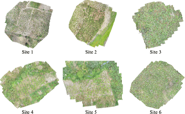
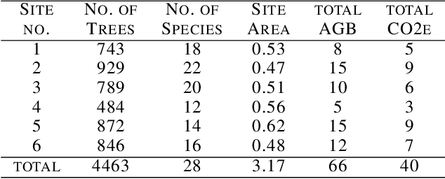
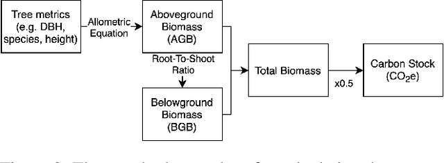
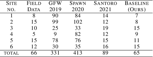
Forest biomass is a key influence for future climate, and the world urgently needs highly scalable financing schemes, such as carbon offsetting certifications, to protect and restore forests. Current manual forest carbon stock inventory methods of measuring single trees by hand are time, labour, and cost-intensive and have been shown to be subjective. They can lead to substantial overestimation of the carbon stock and ultimately distrust in forest financing. The potential for impact and scale of leveraging advancements in machine learning and remote sensing technologies is promising but needs to be of high quality in order to replace the current forest stock protocols for certifications. In this paper, we present ReforesTree, a benchmark dataset of forest carbon stock in six agro-forestry carbon offsetting sites in Ecuador. Furthermore, we show that a deep learning-based end-to-end model using individual tree detection from low cost RGB-only drone imagery is accurately estimating forest carbon stock within official carbon offsetting certification standards. Additionally, our baseline CNN model outperforms state-of-the-art satellite-based forest biomass and carbon stock estimates for this type of small-scale, tropical agro-forestry sites. We present this dataset to encourage machine learning research in this area to increase accountability and transparency of monitoring, verification and reporting (MVR) in carbon offsetting projects, as well as scaling global reforestation financing through accurate remote sensing.
SEN12MS-CR-TS: A Remote Sensing Data Set for Multi-modal Multi-temporal Cloud Removal
Jan 24, 2022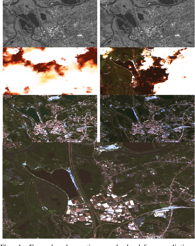
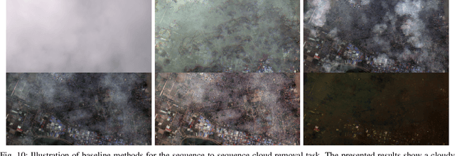
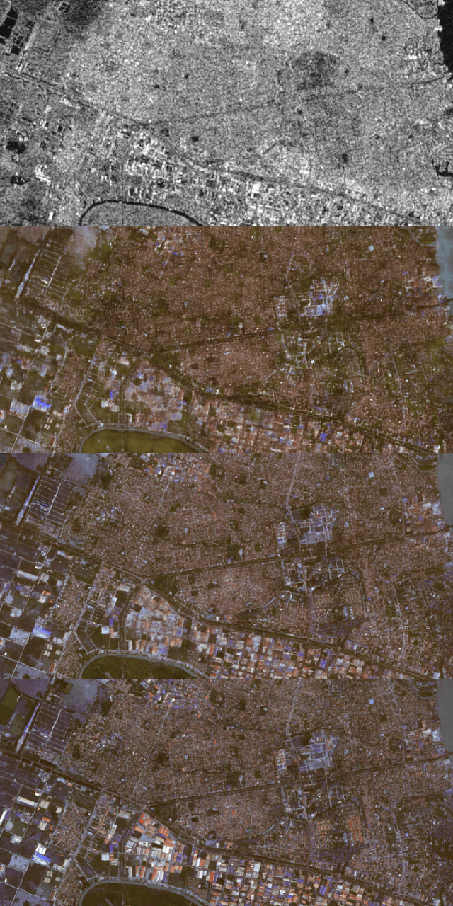
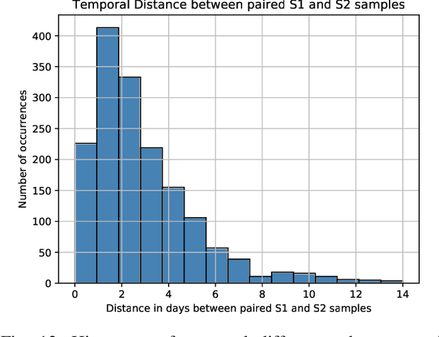
About half of all optical observations collected via spaceborne satellites are affected by haze or clouds. Consequently, cloud coverage affects the remote sensing practitioner's capabilities of a continuous and seamless monitoring of our planet. This work addresses the challenge of optical satellite image reconstruction and cloud removal by proposing a novel multi-modal and multi-temporal data set called SEN12MS-CR-TS. We propose two models highlighting the benefits and use cases of SEN12MS-CR-TS: First, a multi-modal multi-temporal 3D-Convolution Neural Network that predicts a cloud-free image from a sequence of cloudy optical and radar images. Second, a sequence-to-sequence translation model that predicts a cloud-free time series from a cloud-covered time series. Both approaches are evaluated experimentally, with their respective models trained and tested on SEN12MS-CR-TS. The conducted experiments highlight the contribution of our data set to the remote sensing community as well as the benefits of multi-modal and multi-temporal information to reconstruct noisy information. Our data set is available at https://patrickTUM.github.io/cloud_removal