 Add to Chrome
 Add to Firefox
 Add to Edge
Beyond Accuracy: Assessing Calibration of Geospatial Foundation Models and Their Sensitivity to Distribution Shifts
Aug 17, 2026
Geospatial Foundation Models (GeoFMs) are most commonly ranked and selected by accuracy on standard benchmark conditions via averaged ranks. We show that this protocol is too narrow: the promised deployment in critical EO tasks requires further angles of analysis, mainly calibration, the agreement between a model's confidence and its correctness. Across 16 frozen encoders, four classification and five segmentation datasets, and two orthogonal stress axes, every encoder degrades as corruption intensifies, and the ranking changes as well. Across the four classification benchmarks, EO-pretrained and ImageNet-pretrained encoders are indistinguishable on clean accuracy and clean calibration, and EO pretraining provides no more stability under shift than ImageNet pretraining. Under shift the GeoFMs drift further into overconfidence than the ImageNet-pretrained encoders, at every grade and in every corruption family. A centered kernel alignment (CKA) analysis ties this to representational rigidity: EO-pretrained embeddings move less under corruption while losing just as much task information and remaining overconfident. We apply three commonly explored uncertainty quantification methods and find that temperature scaling and deep ensembles cannot counteract the degradation, while a Gaussian-process probe roughly halves ECE under severe cloud only by tripling it on clean data. In selective prediction experiments, we find that confidence-based abstention cannot defer around confidently wrong predictions, and advocate that benchmark rankings and evaluations should therefore operate across a multitude of conditions and metrics to more holistically evaluate model development progress and close the gap to real world deployment scenarios.

No One Knows the State of the Art in Geospatial Foundation Models
May 12, 2026Geospatial foundation models (GFMs) have been proposed as generalizable backbones for disaster response, land-cover mapping, food-security monitoring, and other high-stakes Earth-observation tasks. Yet the published work about these models does not give reviewers or users enough information to tell which model fits a given task. We argue that nobody knows what the current state of the art is in geospatial foundation models. The methods may be useful, but the GFM literature does not standardize evaluations, training and testing protocols, released weights, or pretraining controls well enough for anyone to compare or rank them. In a 152-paper audit, we find 46 cross-paper disagreements of at least 10 points for the same model, benchmark, and protocol; 94/126 papers with extractable pretraining data use a configuration no other paper uses; and 39% of GFM papers release no model weights. This lack of community standards can be solved. We propose six concrete expectations: named-license weight release, shared core evaluations, copied-versus-rerun baseline annotations, variance reporting, one shared evaluation harness, and data-vs-architecture-vs-algorithm controls. These gaps are a coordination failure, not a fault of any individual lab; the authors of this paper, like many others in the GFM community, have contributed to them. Rather than just critiquing the community, we aim to provide concrete steps toward a shared understanding of how to innovate GFMs.
Advancing Earth Observation Through Machine Learning: A TorchGeo Tutorial
Mar 02, 2026Earth observation machine learning pipelines differ fundamentally from standard computer vision workflows. Imagery is typically delivered as large, georeferenced scenes, labels may be raster masks or vector geometries in distinct coordinate reference systems, and both training and evaluation often require spatially aware sampling and splitting strategies. TorchGeo is a PyTorch-based domain library that provides datasets, samplers, transforms and pre-trained models with the goal of making it easy to use geospatial data in machine learning pipelines. In this paper, we introduce a tutorial that demonstrates 1.) the core TorchGeo abstractions through code examples, and 2.) an end-to-end case study on multispectral water segmentation from Sentinel-2 imagery using the Earth Surface Water dataset. This demonstrates how to train a semantic segmentation model using TorchGeo datasets, apply the model to a Sentinel-2 scene over Rio de Janeiro, Brazil, and save the resulting predictions as a GeoTIFF for further geospatial analysis. The tutorial code itself is distributed as two Python notebooks: https://torchgeo.readthedocs.io/en/stable/tutorials/torchgeo.html and https://torchgeo.readthedocs.io/en/stable/tutorials/earth_surface_water.html.
EO-VAE: Towards A Multi-sensor Tokenizer for Earth Observation Data
Feb 12, 2026State-of-the-art generative image and video models rely heavily on tokenizers that compress high-dimensional inputs into more efficient latent representations. While this paradigm has revolutionized RGB generation, Earth observation (EO) data presents unique challenges due to diverse sensor specifications and variable spectral channels. We propose EO-VAE, a multi-sensor variational autoencoder designed to serve as a foundational tokenizer for the EO domain. Unlike prior approaches that train separate tokenizers for each modality, EO-VAE utilizes a single model to encode and reconstruct flexible channel combinations via dynamic hypernetworks. Our experiments on the TerraMesh dataset demonstrate that EO-VAE achieves superior reconstruction fidelity compared to the TerraMind tokenizers, establishing a robust baseline for latent generative modeling in remote sensing.
GEO-Bench-2: From Performance to Capability, Rethinking Evaluation in Geospatial AI
Nov 19, 2025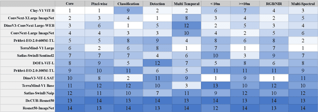
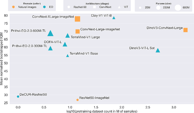
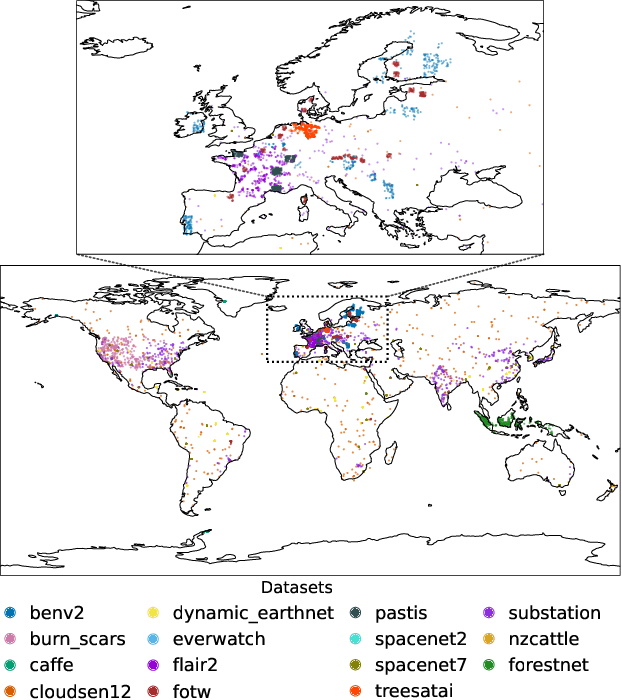
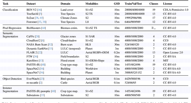
Geospatial Foundation Models (GeoFMs) are transforming Earth Observation (EO), but evaluation lacks standardized protocols. GEO-Bench-2 addresses this with a comprehensive framework spanning classification, segmentation, regression, object detection, and instance segmentation across 19 permissively-licensed datasets. We introduce ''capability'' groups to rank models on datasets that share common characteristics (e.g., resolution, bands, temporality). This enables users to identify which models excel in each capability and determine which areas need improvement in future work. To support both fair comparison and methodological innovation, we define a prescriptive yet flexible evaluation protocol. This not only ensures consistency in benchmarking but also facilitates research into model adaptation strategies, a key and open challenge in advancing GeoFMs for downstream tasks. Our experiments show that no single model dominates across all tasks, confirming the specificity of the choices made during architecture design and pretraining. While models pretrained on natural images (ConvNext ImageNet, DINO V3) excel on high-resolution tasks, EO-specific models (TerraMind, Prithvi, and Clay) outperform them on multispectral applications such as agriculture and disaster response. These findings demonstrate that optimal model choice depends on task requirements, data modalities, and constraints. This shows that the goal of a single GeoFM model that performs well across all tasks remains open for future research. GEO-Bench-2 enables informed, reproducible GeoFM evaluation tailored to specific use cases. Code, data, and leaderboard for GEO-Bench-2 are publicly released under a permissive license.
Panopticon: Advancing Any-Sensor Foundation Models for Earth Observation
Mar 13, 2025Earth observation (EO) data features diverse sensing platforms with varying spectral bands, spatial resolutions, and sensing modalities. While most prior work has constrained inputs to fixed sensors, a new class of any-sensor foundation models able to process arbitrary sensors has recently emerged. Contributing to this line of work, we propose Panopticon, an any-sensor foundation model built on the DINOv2 framework. We extend DINOv2 by (1) treating images of the same geolocation across sensors as natural augmentations, (2) subsampling channels to diversify spectral input, and (3) adding a cross attention over channels as a flexible patch embedding mechanism. By encoding the wavelength and modes of optical and synthetic aperture radar sensors, respectively, Panopticon can effectively process any combination of arbitrary channels. In extensive evaluations, we achieve state-of-the-art performance on GEO-Bench, especially on the widely-used Sentinel-1 and Sentinel-2 sensors, while out-competing other any-sensor models, as well as domain adapted fixed-sensor models on unique sensor configurations. Panopticon enables immediate generalization to both existing and future satellite platforms, advancing sensor-agnostic EO.
GeoLangBind: Unifying Earth Observation with Agglomerative Vision-Language Foundation Models
Mar 08, 2025Earth observation (EO) data, collected from diverse sensors with varying imaging principles, present significant challenges in creating unified analytical frameworks. We present GeoLangBind, a novel agglomerative vision--language foundation model that bridges the gap between heterogeneous EO data modalities using language as a unifying medium. Our approach aligns different EO data types into a shared language embedding space, enabling seamless integration and complementary feature learning from diverse sensor data. To achieve this, we construct a large-scale multimodal image--text dataset, GeoLangBind-2M, encompassing six data modalities. GeoLangBind leverages this dataset to develop a zero-shot foundation model capable of processing arbitrary numbers of EO data channels as input. Through our designed Modality-aware Knowledge Agglomeration (MaKA) module and progressive multimodal weight merging strategy, we create a powerful agglomerative foundation model that excels in both zero-shot vision--language comprehension and fine-grained visual understanding. Extensive evaluation across 23 datasets covering multiple tasks demonstrates GeoLangBind's superior performance and versatility in EO applications, offering a robust framework for various environmental monitoring and analysis tasks. The dataset and pretrained models will be publicly available.
Lightning UQ Box: A Comprehensive Framework for Uncertainty Quantification in Deep Learning
Oct 04, 2024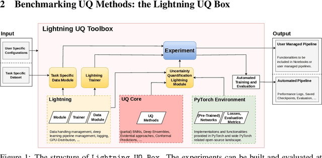


Uncertainty quantification (UQ) is an essential tool for applying deep neural networks (DNNs) to real world tasks, as it attaches a degree of confidence to DNN outputs. However, despite its benefits, UQ is often left out of the standard DNN workflow due to the additional technical knowledge required to apply and evaluate existing UQ procedures. Hence there is a need for a comprehensive toolbox that allows the user to integrate UQ into their modelling workflow, without significant overhead. We introduce \texttt{Lightning UQ Box}: a unified interface for applying and evaluating various approaches to UQ. In this paper, we provide a theoretical and quantitative comparison of the wide range of state-of-the-art UQ methods implemented in our toolbox. We focus on two challenging vision tasks: (i) estimating tropical cyclone wind speeds from infrared satellite imagery and (ii) estimating the power output of solar panels from RGB images of the sky. By highlighting the differences between methods our results demonstrate the need for a broad and approachable experimental framework for UQ, that can be used for benchmarking UQ methods. The toolbox, example implementations, and further information are available at: https://github.com/lightning-uq-box/lightning-uq-box
Uncertainty Aware Tropical Cyclone Wind Speed Estimation from Satellite Data
Apr 12, 2024

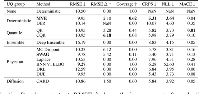

Deep neural networks (DNNs) have been successfully applied to earth observation (EO) data and opened new research avenues. Despite the theoretical and practical advances of these techniques, DNNs are still considered black box tools and by default are designed to give point predictions. However, the majority of EO applications demand reliable uncertainty estimates that can support practitioners in critical decision making tasks. This work provides a theoretical and quantitative comparison of existing uncertainty quantification methods for DNNs applied to the task of wind speed estimation in satellite imagery of tropical cyclones. We provide a detailed evaluation of predictive uncertainty estimates from state-of-the-art uncertainty quantification (UQ) methods for DNNs. We find that predictive uncertainties can be utilized to further improve accuracy and analyze the predictive uncertainties of different methods across storm categories.
SSL4EO-L: Datasets and Foundation Models for Landsat Imagery
Jun 15, 2023

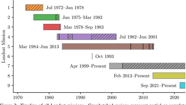

The Landsat program is the longest-running Earth observation program in history, with 50+ years of data acquisition by 8 satellites. The multispectral imagery captured by sensors onboard these satellites is critical for a wide range of scientific fields. Despite the increasing popularity of deep learning and remote sensing, the majority of researchers still use decision trees and random forests for Landsat image analysis due to the prevalence of small labeled datasets and lack of foundation models. In this paper, we introduce SSL4EO-L, the first ever dataset designed for Self-Supervised Learning for Earth Observation for the Landsat family of satellites (including 3 sensors and 2 product levels) and the largest Landsat dataset in history (5M image patches). Additionally, we modernize and re-release the L7 Irish and L8 Biome cloud detection datasets, and introduce the first ML benchmark datasets for Landsats 4-5 TM and Landsat 7 ETM+ SR. Finally, we pre-train the first foundation models for Landsat imagery using SSL4EO-L and evaluate their performance on multiple semantic segmentation tasks. All datasets and model weights are available via the TorchGeo (https://github.com/microsoft/torchgeo) library, making reproducibility and experimentation easy, and enabling scientific advancements in the burgeoning field of remote sensing for a myriad of downstream applications.