 Add to Chrome
 Add to Firefox
 Add to Edge
Nemotron-Labs-TwoTower: Diffusion Language Modeling with Pretrained Autoregressive Context
Jun 29, 2026Diffusion language models offer a promising alternative to autoregressive models due to their potential for parallel and iterative generation. However, existing approaches use a single network for both context representation and iterative denoising, forcing one model to serve both roles and limiting its capacity for either role. We propose TwoTower, a block-wise autoregressive diffusion model that decouples these roles into two towers: a frozen AR context tower that causally processes clean tokens, and a trainable diffusion denoiser tower with bidirectional block attention that refines noisy blocks via cross-attention to the context. Built on Nemotron-3-Nano-30B-A3B, an open-weight 30B hybrid Mamba-Transformer MoE model, and trained on approximately 2.1T tokens, Nemotron-Labs-TwoTower retains 98.7% of the autoregressive baseline's quality while offering 2.42X higher wall-clock generation throughput. We release the code and model weights at https://huggingface.co/collections/nvidia/nemotron-labs-twotower.
Nemotron-TwoTower: Diffusion Language Modeling with Pretrained Autoregressive Context
Jun 25, 2026Diffusion language models offer a promising alternative to autoregressive models due to their potential for parallel and iterative generation. However, existing approaches use a single network for both context representation and iterative denoising, forcing one model to serve both roles and limiting its capacity for either role. We propose TwoTower, a block-wise autoregressive diffusion model that decouples these roles into two towers: a frozen AR context tower that causally processes clean tokens, and a trainable diffusion denoiser tower with bidirectional block attention that refines noisy blocks via cross-attention to the context. Built on Nemotron-3-Nano-30B-A3B, an open-weight 30B hybrid Mamba-Transformer MoE model, and trained on approximately 2.1T tokens, Nemotron-TwoTower retains 98.7% of the autoregressive baseline's quality while offering 2.42X higher wall-clock generation throughput. We release the code and model weights at https://huggingface.co/collections/nvidia/nemotron-twotower.
Nemotron 3 Ultra: Open, Efficient Mixture-of-Experts Hybrid Mamba-Transformer Model for Agentic Reasoning
Jun 12, 2026We introduce Nemotron 3 Ultra, a 550 billion total and 55 billion active parameter Mixture-of-Experts Hybrid Mamba-Attention language model. We pre-trained Nemotron 3 Ultra on 20 trillion text tokens, then extended the context length to 1M tokens, and post-trained using Supervised Fine Tuning (SFT), Reinforcement Learning (RL), and Multi-teacher On-Policy Distillation (MOPD). Nemotron 3 Ultra is our most capable model yet, employing multiple key technologies - LatentMoE, Multi Token Prediction (MTP), NVFP4 pre-training, multi-environment RLVR, MOPD, and reasoning budget control. Nemotron 3 Ultra achieves up to ~6x higher inference throughput as compared to state-of-the-art publicly available LLMs while attaining on-par accuracy. The state-of-the-art accuracy, high inference throughput, and 1M token context length make Nemotron 3 Ultra ideal for long-running autonomous agentic tasks. We open-source the base, post-trained, and quantized checkpoints, along with the training data and recipe on HuggingFace.
Nemotron 3 Super: Open, Efficient Mixture-of-Experts Hybrid Mamba-Transformer Model for Agentic Reasoning
Apr 14, 2026We describe the pre-training, post-training, and quantization of Nemotron 3 Super, a 120 billion (active 12 billion) parameter hybrid Mamba-Attention Mixture-of-Experts model. Nemotron 3 Super is the first model in the Nemotron 3 family to 1) be pre-trained in NVFP4, 2) leverage LatentMoE, a new Mixture-of-Experts architecture that optimizes for both accuracy per FLOP and accuracy per parameter, and 3) include MTP layers for inference acceleration through native speculative decoding. We pre-trained Nemotron 3 Super on 25 trillion tokens followed by post-training using supervised fine tuning (SFT) and reinforcement learning (RL). The final model supports up to 1M context length and achieves comparable accuracy on common benchmarks, while also achieving up to 2.2x and 7.5x higher inference throughput compared to GPT-OSS-120B and Qwen3.5-122B, respectively. Nemotron 3 Super datasets, along with the base, post-trained, and quantized checkpoints, are open-sourced on HuggingFace.
NVIDIA Nemotron 3: Efficient and Open Intelligence
Dec 24, 2025We introduce the Nemotron 3 family of models - Nano, Super, and Ultra. These models deliver strong agentic, reasoning, and conversational capabilities. The Nemotron 3 family uses a Mixture-of-Experts hybrid Mamba-Transformer architecture to provide best-in-class throughput and context lengths of up to 1M tokens. Super and Ultra models are trained with NVFP4 and incorporate LatentMoE, a novel approach that improves model quality. The two larger models also include MTP layers for faster text generation. All Nemotron 3 models are post-trained using multi-environment reinforcement learning enabling reasoning, multi-step tool use, and support granular reasoning budget control. Nano, the smallest model, outperforms comparable models in accuracy while remaining extremely cost-efficient for inference. Super is optimized for collaborative agents and high-volume workloads such as IT ticket automation. Ultra, the largest model, provides state-of-the-art accuracy and reasoning performance. Nano is released together with its technical report and this white paper, while Super and Ultra will follow in the coming months. We will openly release the model weights, pre- and post-training software, recipes, and all data for which we hold redistribution rights.
Nemotron 3 Nano: Open, Efficient Mixture-of-Experts Hybrid Mamba-Transformer Model for Agentic Reasoning
Dec 23, 2025We present Nemotron 3 Nano 30B-A3B, a Mixture-of-Experts hybrid Mamba-Transformer language model. Nemotron 3 Nano was pretrained on 25 trillion text tokens, including more than 3 trillion new unique tokens over Nemotron 2, followed by supervised fine tuning and large-scale RL on diverse environments. Nemotron 3 Nano achieves better accuracy than our previous generation Nemotron 2 Nano while activating less than half of the parameters per forward pass. It achieves up to 3.3x higher inference throughput than similarly-sized open models like GPT-OSS-20B and Qwen3-30B-A3B-Thinking-2507, while also being more accurate on popular benchmarks. Nemotron 3 Nano demonstrates enhanced agentic, reasoning, and chat abilities and supports context lengths up to 1M tokens. We release both our pretrained Nemotron 3 Nano 30B-A3B Base and post-trained Nemotron 3 Nano 30B-A3B checkpoints on Hugging Face.
NVIDIA Nemotron Nano 2: An Accurate and Efficient Hybrid Mamba-Transformer Reasoning Model
Aug 21, 2025


We introduce Nemotron-Nano-9B-v2, a hybrid Mamba-Transformer language model designed to increase throughput for reasoning workloads while achieving state-of-the-art accuracy compared to similarly-sized models. Nemotron-Nano-9B-v2 builds on the Nemotron-H architecture, in which the majority of the self-attention layers in the common Transformer architecture are replaced with Mamba-2 layers, to achieve improved inference speed when generating the long thinking traces needed for reasoning. We create Nemotron-Nano-9B-v2 by first pre-training a 12-billion-parameter model (Nemotron-Nano-12B-v2-Base) on 20 trillion tokens using an FP8 training recipe. After aligning Nemotron-Nano-12B-v2-Base, we employ the Minitron strategy to compress and distill the model with the goal of enabling inference on up to 128k tokens on a single NVIDIA A10G GPU (22GiB of memory, bfloat16 precision). Compared to existing similarly-sized models (e.g., Qwen3-8B), we show that Nemotron-Nano-9B-v2 achieves on-par or better accuracy on reasoning benchmarks while achieving up to 6x higher inference throughput in reasoning settings like 8k input and 16k output tokens. We are releasing Nemotron-Nano-9B-v2, Nemotron-Nano12B-v2-Base, and Nemotron-Nano-9B-v2-Base checkpoints along with the majority of our pre- and post-training datasets on Hugging Face.
Llama-Nemotron: Efficient Reasoning Models
May 02, 2025


We introduce the Llama-Nemotron series of models, an open family of heterogeneous reasoning models that deliver exceptional reasoning capabilities, inference efficiency, and an open license for enterprise use. The family comes in three sizes -- Nano (8B), Super (49B), and Ultra (253B) -- and performs competitively with state-of-the-art reasoning models such as DeepSeek-R1 while offering superior inference throughput and memory efficiency. In this report, we discuss the training procedure for these models, which entails using neural architecture search from Llama 3 models for accelerated inference, knowledge distillation, and continued pretraining, followed by a reasoning-focused post-training stage consisting of two main parts: supervised fine-tuning and large scale reinforcement learning. Llama-Nemotron models are the first open-source models to support a dynamic reasoning toggle, allowing users to switch between standard chat and reasoning modes during inference. To further support open research and facilitate model development, we provide the following resources: 1. We release the Llama-Nemotron reasoning models -- LN-Nano, LN-Super, and LN-Ultra -- under the commercially permissive NVIDIA Open Model License Agreement. 2. We release the complete post-training dataset: Llama-Nemotron-Post-Training-Dataset. 3. We also release our training codebases: NeMo, NeMo-Aligner, and Megatron-LM.
Nemotron-H: A Family of Accurate and Efficient Hybrid Mamba-Transformer Models
Apr 10, 2025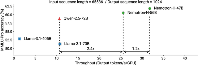
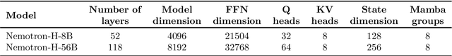
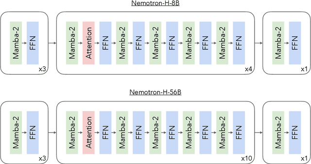
As inference-time scaling becomes critical for enhanced reasoning capabilities, it is increasingly becoming important to build models that are efficient to infer. We introduce Nemotron-H, a family of 8B and 56B/47B hybrid Mamba-Transformer models designed to reduce inference cost for a given accuracy level. To achieve this goal, we replace the majority of self-attention layers in the common Transformer model architecture with Mamba layers that perform constant computation and require constant memory per generated token. We show that Nemotron-H models offer either better or on-par accuracy compared to other similarly-sized state-of-the-art open-sourced Transformer models (e.g., Qwen-2.5-7B/72B and Llama-3.1-8B/70B), while being up to 3$\times$ faster at inference. To further increase inference speed and reduce the memory required at inference time, we created Nemotron-H-47B-Base from the 56B model using a new compression via pruning and distillation technique called MiniPuzzle. Nemotron-H-47B-Base achieves similar accuracy to the 56B model, but is 20% faster to infer. In addition, we introduce an FP8-based training recipe and show that it can achieve on par results with BF16-based training. This recipe is used to train the 56B model. All Nemotron-H models will be released, with support in Hugging Face, NeMo, and Megatron-LM.
MIND: Math Informed syNthetic Dialogues for Pretraining LLMs
Oct 15, 2024


The utility of synthetic data to enhance pretraining data quality and hence to improve downstream task accuracy has been widely explored in recent large language models (LLMs). Yet, these approaches fall inadequate in complex, multi-hop and mathematical reasoning tasks as the synthetic data typically fails to add complementary knowledge to the existing raw corpus. In this work, we propose a novel large-scale and diverse Math Informed syNthetic Dialogue (MIND) generation method that improves the mathematical reasoning ability of LLMs. Specifically, using MIND, we generate synthetic conversations based on OpenWebMath (OWM), resulting in a new math corpus, MIND-OWM. Our experiments with different conversational settings reveal that incorporating knowledge gaps between dialog participants is essential for generating high-quality math data. We further identify an effective way to format and integrate synthetic and raw data during pretraining to maximize the gain in mathematical reasoning, emphasizing the need to restructure raw data rather than use it as-is. Compared to pretraining just on raw data, a model pretrained on MIND-OWM shows significant boost in mathematical reasoning (GSM8K: +13.42%, MATH: +2.30%), including superior performance in specialized knowledge (MMLU: +4.55%, MMLU-STEM: +4.28%) and general purpose reasoning tasks (GENERAL REASONING: +2.51%).