 Add to Chrome
 Add to Firefox
 Add to Edge
From Foundation to Application: Improving VLA Models in Practice
Jul 07, 2026
Despite recent progress of VLA foundation models, the disparity between laboratory conditions and real-world applications continues to impede their practical implementation. To bridge this gap, we present LingBot-VLA 2.0, which advances LingBot-VLA through improvements in three functional domains. (1) Generalization across tasks and embodiments. Compared to the previous version, we revamp the data processing pipeline and curate around 60,000 hours of data for pretraining, including 50,000 hours of robot trajectories spanning 20 robot configurations and 10,000 hours of egocentric human videos. (2) Expanded action space in addition to dual-arm hardware platforms. In particular, our system accommodates degrees of freedom for the heads, waists, mobile bases, and dexterous hands, thereby empowering the robots to tackle more complex tasks in practical scenarios. (3) Predictive dynamics modeling for improved temporal reasoning. Specifically, we formulate future prediction as a proxy task, facilitated by a video representation model for semantic priors and a depth estimation model for geometric cues. Evaluations on the GM-100 benchmark, conducted in a generalist setting, validate the beneficial impact of these proposed modifications. Furthermore, benefiting from the expanded pretraining data that covers whole-body degrees of freedom, LingBot-VLA-2.0 demonstrates strong cross-embodiment long-horizon mobile manipulation capability across the two robotic platforms.

Vision Pretraining for Dense Spatial Perception
Jul 06, 2026Dense spatial perception is essential for physical intelligence, where visual systems are expected to recover structured, metric, and actionable representations from pixel observations. Modern visual foundation models tend to prioritize semantic invariance, often at the expense of detailed spatial understanding. In this work, we study vision pretraining through a boundary-centric lens, motivated by the premise that boundaries and shape discontinuities offer essential cues for perceiving geometric properties. Concretely, we propose masked boundary modeling, a self-supervised paradigm that dynamically learns sub-pixel boundary representations and subsequently leverages the discovered boundary-bearing tokens as masked targets to facilitate dense visual token learning. By scaling this framework, we develop LingBot-Vision and demonstrate its efficacy across a diverse set of downstream vision tasks with DINOv3 as a strong baseline. Remarkably, LingBot-Vision drives the progression from LingBot-Depth 1.0 to LingBot-Depth 2.0 for depth completion, and thereby yields enhanced depth estimation, a key pillar for embodied artificial intelligence. Our findings reveal that boundary modeling goes beyond simple line segments and instead serves as a scalable pretraining principle for learning spatially structured visual representations.
Sat3DGen: Comprehensive Street-Level 3D Scene Generation from Single Satellite Image
May 14, 2026Generating a street-level 3D scene from a single satellite image is a crucial yet challenging task. Current methods present a stark trade-off: geometry-colorization models achieve high geometric fidelity but are typically building-focused and lack semantic diversity. In contrast, proxy-based models use feed-forward image-to-3D frameworks to generate holistic scenes by jointly learning geometry and texture, a process that yields rich content but coarse and unstable geometry. We attribute these geometric failures to the extreme viewpoint gap and sparse, inconsistent supervision inherent in satellite-to-street data. We introduce Sat3DGen to address these fundamental challenges, which embodies a geometry-first methodology. This methodology enhances the feed-forward paradigm by integrating novel geometric constraints with a perspective-view training strategy, explicitly countering the primary sources of geometric error. This geometry-centric strategy yields a dramatic leap in both 3D accuracy and photorealism. For validation, we first constructed a new benchmark by pairing the VIGOR-OOD test set with high-resolution DSM data. On this benchmark, our method improves geometric RMSE from 6.76m to 5.20m. Crucially, this geometric leap also boosts photorealism, reducing the Fréchet Inception Distance (FID) from $\sim$40 to 19 against the leading method, Sat2Density++, despite using no extra tailored image-quality modules. We demonstrate the versatility of our high-quality 3D assets through diverse downstream applications, including semantic-map-to-3D synthesis, multi-camera video generation, large-scale meshing, and unsupervised single-image Digital Surface Model (DSM) estimation. The code has been released on https://github.com/qianmingduowan/Sat3DGen.
Interacted Planes Reveal 3D Line Mapping
Feb 01, 20263D line mapping from multi-view RGB images provides a compact and structured visual representation of scenes. We study the problem from a physical and topological perspective: a 3D line most naturally emerges as the edge of a finite 3D planar patch. We present LiP-Map, a line-plane joint optimization framework that explicitly models learnable line and planar primitives. This coupling enables accurate and detailed 3D line mapping while maintaining strong efficiency (typically completing a reconstruction in 3 to 5 minutes per scene). LiP-Map pioneers the integration of planar topology into 3D line mapping, not by imposing pairwise coplanarity constraints but by explicitly constructing interactions between plane and line primitives, thus offering a principled route toward structured reconstruction in man-made environments. On more than 100 scenes from ScanNetV2, ScanNet++, Hypersim, 7Scenes, and Tanks\&Temple, LiP-Map improves both accuracy and completeness over state-of-the-art methods. Beyond line mapping quality, LiP-Map significantly advances line-assisted visual localization, establishing strong performance on 7Scenes. Our code is released at https://github.com/calmke/LiPMAP for reproducible research.
Masked Depth Modeling for Spatial Perception
Jan 25, 2026Spatial visual perception is a fundamental requirement in physical-world applications like autonomous driving and robotic manipulation, driven by the need to interact with 3D environments. Capturing pixel-aligned metric depth using RGB-D cameras would be the most viable way, yet it usually faces obstacles posed by hardware limitations and challenging imaging conditions, especially in the presence of specular or texture-less surfaces. In this work, we argue that the inaccuracies from depth sensors can be viewed as "masked" signals that inherently reflect underlying geometric ambiguities. Building on this motivation, we present LingBot-Depth, a depth completion model which leverages visual context to refine depth maps through masked depth modeling and incorporates an automated data curation pipeline for scalable training. It is encouraging to see that our model outperforms top-tier RGB-D cameras in terms of both depth precision and pixel coverage. Experimental results on a range of downstream tasks further suggest that LingBot-Depth offers an aligned latent representation across RGB and depth modalities. We release the code, checkpoint, and 3M RGB-depth pairs (including 2M real data and 1M simulated data) to the community of spatial perception.
PCR-CA: Parallel Codebook Representations with Contrastive Alignment for Multiple-Category App Recommendation
Aug 25, 2025Modern app store recommender systems struggle with multiple-category apps, as traditional taxonomies fail to capture overlapping semantics, leading to suboptimal personalization. We propose PCR-CA (Parallel Codebook Representations with Contrastive Alignment), an end-to-end framework for improved CTR prediction. PCR-CA first extracts compact multimodal embeddings from app text, then introduces a Parallel Codebook VQ-AE module that learns discrete semantic representations across multiple codebooks in parallel -- unlike hierarchical residual quantization (RQ-VAE). This design enables independent encoding of diverse aspects (e.g., gameplay, art style), better modeling multiple-category semantics. To bridge semantic and collaborative signals, we employ a contrastive alignment loss at both the user and item levels, enhancing representation learning for long-tail items. Additionally, a dual-attention fusion mechanism combines ID-based and semantic features to capture user interests, especially for long-tail apps. Experiments on a large-scale dataset show PCR-CA achieves a +0.76% AUC improvement over strong baselines, with +2.15% AUC gains for long-tail apps. Online A/B testing further validates our approach, showing a +10.52% lift in CTR and a +16.30% improvement in CVR, demonstrating PCR-CA's effectiveness in real-world deployment. The new framework has now been fully deployed on the Microsoft Store.
ScaleLSD: Scalable Deep Line Segment Detection Streamlined
Jun 11, 2025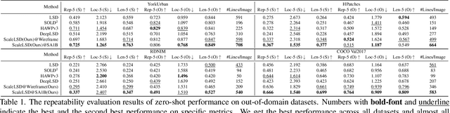
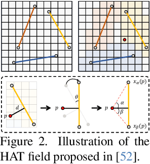
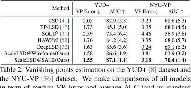
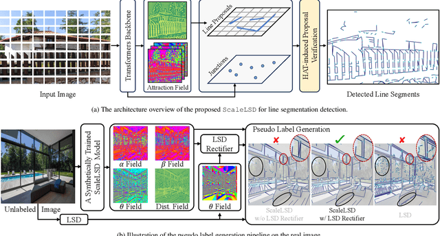
This paper studies the problem of Line Segment Detection (LSD) for the characterization of line geometry in images, with the aim of learning a domain-agnostic robust LSD model that works well for any natural images. With the focus of scalable self-supervised learning of LSD, we revisit and streamline the fundamental designs of (deep and non-deep) LSD approaches to have a high-performing and efficient LSD learner, dubbed as ScaleLSD, for the curation of line geometry at scale from over 10M unlabeled real-world images. Our ScaleLSD works very well to detect much more number of line segments from any natural images even than the pioneered non-deep LSD approach, having a more complete and accurate geometric characterization of images using line segments. Experimentally, our proposed ScaleLSD is comprehensively testified under zero-shot protocols in detection performance, single-view 3D geometry estimation, two-view line segment matching, and multiview 3D line mapping, all with excellent performance obtained. Based on the thorough evaluation, our ScaleLSD is observed to be the first deep approach that outperforms the pioneered non-deep LSD in all aspects we have tested, significantly expanding and reinforcing the versatility of the line geometry of images. Code and Models are available at https://github.com/ant-research/scalelsd
Seeing through Satellite Images at Street Views
May 22, 2025This paper studies the task of SatStreet-view synthesis, which aims to render photorealistic street-view panorama images and videos given any satellite image and specified camera positions or trajectories. We formulate to learn neural radiance field from paired images captured from satellite and street viewpoints, which comes to be a challenging learning problem due to the sparse-view natural and the extremely-large viewpoint changes between satellite and street-view images. We tackle the challenges based on a task-specific observation that street-view specific elements, including the sky and illumination effects are only visible in street-view panoramas, and present a novel approach Sat2Density++ to accomplish the goal of photo-realistic street-view panoramas rendering by modeling these street-view specific in neural networks. In the experiments, our method is testified on both urban and suburban scene datasets, demonstrating that Sat2Density++ is capable of rendering photorealistic street-view panoramas that are consistent across multiple views and faithful to the satellite image.
DepthLab: From Partial to Complete
Dec 24, 2024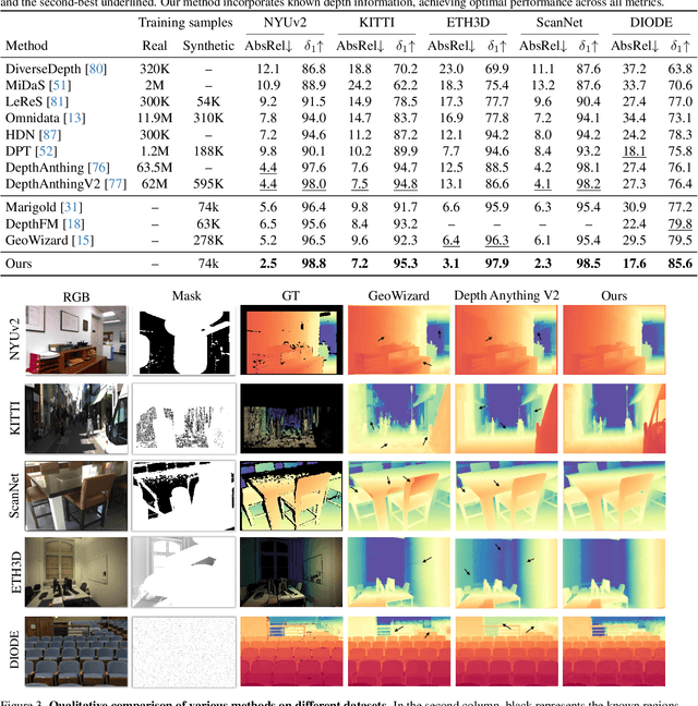
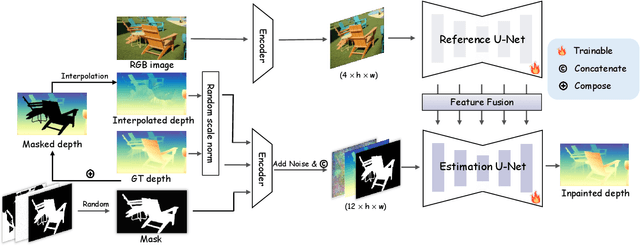

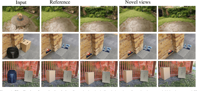
Missing values remain a common challenge for depth data across its wide range of applications, stemming from various causes like incomplete data acquisition and perspective alteration. This work bridges this gap with DepthLab, a foundation depth inpainting model powered by image diffusion priors. Our model features two notable strengths: (1) it demonstrates resilience to depth-deficient regions, providing reliable completion for both continuous areas and isolated points, and (2) it faithfully preserves scale consistency with the conditioned known depth when filling in missing values. Drawing on these advantages, our approach proves its worth in various downstream tasks, including 3D scene inpainting, text-to-3D scene generation, sparse-view reconstruction with DUST3R, and LiDAR depth completion, exceeding current solutions in both numerical performance and visual quality. Our project page with source code is available at https://johanan528.github.io/depthlab_web/.
PlanarSplatting: Accurate Planar Surface Reconstruction in 3 Minutes
Dec 04, 2024
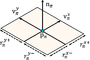
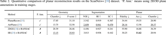
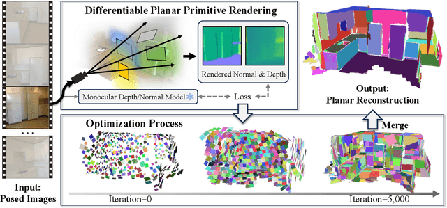
This paper presents PlanarSplatting, an ultra-fast and accurate surface reconstruction approach for multiview indoor images. We take the 3D planes as the main objective due to their compactness and structural expressiveness in indoor scenes, and develop an explicit optimization framework that learns to fit the expected surface of indoor scenes by splatting the 3D planes into 2.5D depth and normal maps. As our PlanarSplatting operates directly on the 3D plane primitives, it eliminates the dependencies on 2D/3D plane detection and plane matching and tracking for planar surface reconstruction. Furthermore, the essential merits of plane-based representation plus CUDA-based implementation of planar splatting functions, PlanarSplatting reconstructs an indoor scene in 3 minutes while having significantly better geometric accuracy. Thanks to our ultra-fast reconstruction speed, the largest quantitative evaluation on the ScanNet and ScanNet++ datasets over hundreds of scenes clearly demonstrated the advantages of our method. We believe that our accurate and ultrafast planar surface reconstruction method will be applied in the structured data curation for surface reconstruction in the future. The code of our CUDA implementation will be publicly available. Project page: https://icetttb.github.io/PlanarSplatting/