 Add to Chrome
 Add to Firefox
 Add to Edge
Remote-Sensing City Layout Extraction with MLLM
Aug 17, 2026
Remote-sensing systems usually describe urban content with detection boxes, semantic masks, or vector boundaries. Such outputs locate classes and support image-plane scoring, yet they do not by themselves constitute an executable layout that retains object identities, typed relations, topology, and regeneration rules. Code-as-City instead casts urban-layout extraction from a single top-down image as constrained code generation with a multimodal large language model (MLLM). An image model first produces an aligned five-class semantic layout prior. Three ordered MLLM passes use the image and this prior to recover roads, land-cover regions and relations, and buildings. Deterministic normalization converts the accumulated records into a city graph and a restricted layout program. Executing the program creates a renderable 3D city layout and an orthographic semantic projection over shared geometry. The projection admits pixel-level comparison with remote-sensing masks, while named objects, relations, and editing operations remain available for synchronized regeneration of both views. Evaluated on the 100 scenes of CityLayout-100, the complete framework obtains 41.1% mean intersection-over-union and 48.3% global intersection-over-union. This result provides quantitative evidence that visual observations can be translated into inspectable, editable city code with coupled planar and 3D outputs.

ObliCity: A Benchmark and Baseline for Roof-to-Ground Projection Displacement Correction
Jul 28, 2026Oblique-view urban remote sensing imagery inevitably exhibits geometric projection displacements between building roofs and footprints, leading to significant distortions in spatial structure. Existing approaches either ignore these deformations or handle them implicitly within segmentation-based frameworks, where progress is dominated by general segmentation advances rather than improvements in geometric correction. In this work, we explicitly define roof-to-footprint offset vector (RFOV) extraction as an independent learning task that decouples geometric alignment from semantic segmentation. To support this task, we introduce the Oblique City dataset (ObliCity), the first large-scale benchmark that integrates high-resolution UAV imagery and globally distributed satellite data, covering diverse city morphologies and camera perspectives. Methodologically, we reformulate DragOSM into DragRoof, an ODE-based framework inspired by human annotation behavior. By simulating the continuous process of dragging roofs toward their footprints, DragRoof learns deterministic, geometry-consistent offset fields and adaptively determines convergence through an end token. Extensive experiments on ObliCity demonstrate that DragRoof achieves state-of-the-art RFOV extraction performance, requiring fewer inference steps while delivering superior directional and length accuracy. Our dataset and model establish a principled foundation for studying projection displacement correction in oblique remote sensing imagery. The source code and dataset will be avaliable at https://github.com/likaiucas/DragRoof.
SegEarth-OV3: Exploring SAM 3 for Open-Vocabulary Semantic Segmentation in Remote Sensing Images
Dec 09, 2025Most existing methods for training-free Open-Vocabulary Semantic Segmentation (OVSS) are based on CLIP. While these approaches have made progress, they often face challenges in precise localization or require complex pipelines to combine separate modules, especially in remote sensing scenarios where numerous dense and small targets are present. Recently, Segment Anything Model 3 (SAM 3) was proposed, unifying segmentation and recognition in a promptable framework. In this paper, we present a preliminary exploration of applying SAM 3 to the remote sensing OVSS task without any training. First, we implement a mask fusion strategy that combines the outputs from SAM 3's semantic segmentation head and the Transformer decoder (instance head). This allows us to leverage the strengths of both heads for better land coverage. Second, we utilize the presence score from the presence head to filter out categories that do not exist in the scene, reducing false positives caused by the vast vocabulary sizes and patch-level processing in geospatial scenes. We evaluate our method on extensive remote sensing datasets. Experiments show that this simple adaptation achieves promising performance, demonstrating the potential of SAM 3 for remote sensing OVSS. Our code is released at https://github.com/earth-insights/SegEarth-OV-3.
GLD-Road:A global-local decoding road network extraction model for remote sensing images
Jun 11, 2025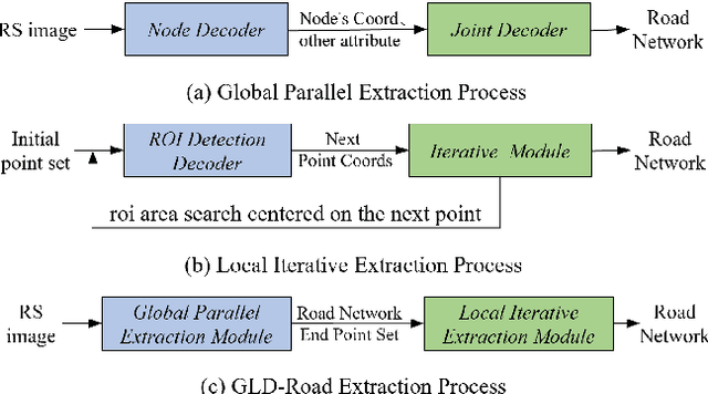
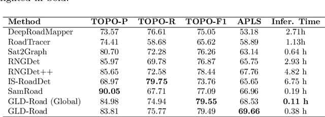
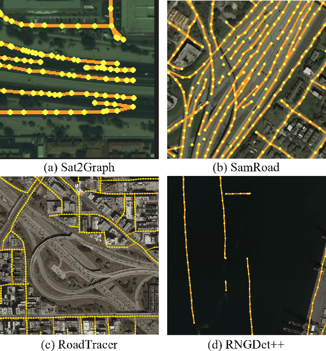
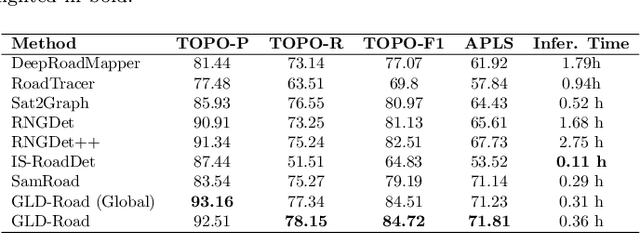
Road networks are crucial for mapping, autonomous driving, and disaster response. While manual annotation is costly, deep learning offers efficient extraction. Current methods include postprocessing (prone to errors), global parallel (fast but misses nodes), and local iterative (accurate but slow). We propose GLD-Road, a two-stage model combining global efficiency and local precision. First, it detects road nodes and connects them via a Connect Module. Then, it iteratively refines broken roads using local searches, drastically reducing computation. Experiments show GLD-Road outperforms state-of-the-art methods, improving APLS by 1.9% (City-Scale) and 0.67% (SpaceNet3). It also reduces retrieval time by 40% vs. Sat2Graph (global) and 92% vs. RNGDet++ (local). The experimental results are available at https://github.com/ucas-dlg/GLD-Road.
SegEarth-R1: Geospatial Pixel Reasoning via Large Language Model
Apr 13, 2025Remote sensing has become critical for understanding environmental dynamics, urban planning, and disaster management. However, traditional remote sensing workflows often rely on explicit segmentation or detection methods, which struggle to handle complex, implicit queries that require reasoning over spatial context, domain knowledge, and implicit user intent. Motivated by this, we introduce a new task, \ie, geospatial pixel reasoning, which allows implicit querying and reasoning and generates the mask of the target region. To advance this task, we construct and release the first large-scale benchmark dataset called EarthReason, which comprises 5,434 manually annotated image masks with over 30,000 implicit question-answer pairs. Moreover, we propose SegEarth-R1, a simple yet effective language-guided segmentation baseline that integrates a hierarchical visual encoder, a large language model (LLM) for instruction parsing, and a tailored mask generator for spatial correlation. The design of SegEarth-R1 incorporates domain-specific adaptations, including aggressive visual token compression to handle ultra-high-resolution remote sensing images, a description projection module to fuse language and multi-scale features, and a streamlined mask prediction pipeline that directly queries description embeddings. Extensive experiments demonstrate that SegEarth-R1 achieves state-of-the-art performance on both reasoning and referring segmentation tasks, significantly outperforming traditional and LLM-based segmentation methods. Our data and code will be released at https://github.com/earth-insights/SegEarth-R1.
LRSCLIP: A Vision-Language Foundation Model for Aligning Remote Sensing Image with Longer Text
Mar 25, 2025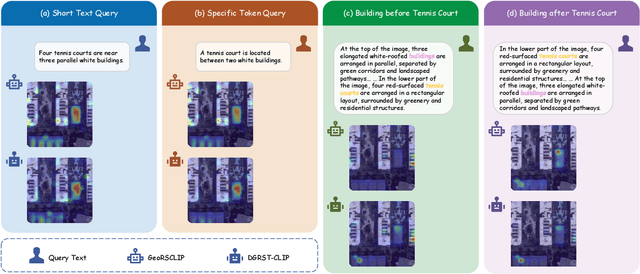
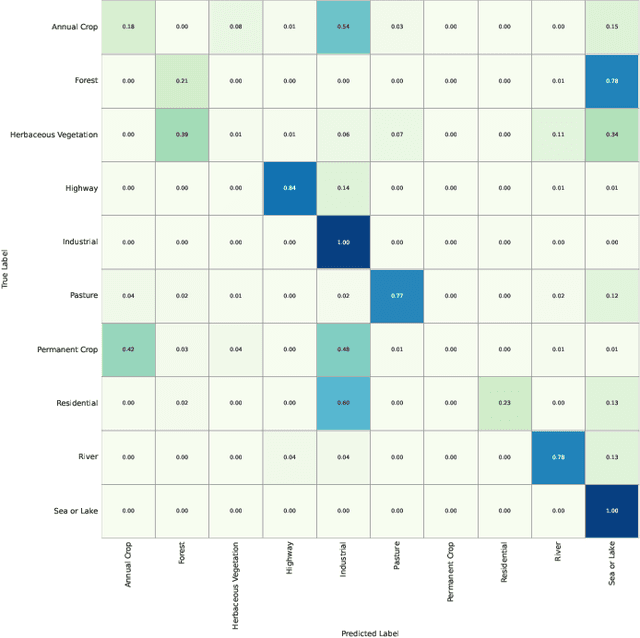
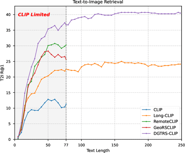
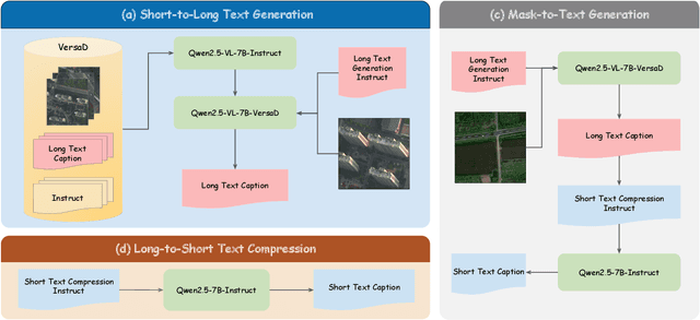
This study addresses the technical bottlenecks in handling long text and the "hallucination" issue caused by insufficient short text information in remote sensing vision-language foundation models (VLFM). We propose a novel vision-language foundation model, LRSCLIP, and a multimodal dataset, LRS2M. The main contributions are as follows: (1) By integrating multi-source remote sensing data and adopting a large language model labeling strategy, we construct the LRS2M dataset, which contains 2 million image-text pairs, providing both short and long texts for the first time, thus solving the problem of semantic granularity limitations in existing datasets; (2) The design of the LRSCLIP architecture based on Long-CLIP's KPS module, which extends CLIP's text processing capacity and achieves fine-grained cross-modal feature alignment through a dual-text loss weighting mechanism. Experimental results show that LRSCLIP improves retrieval accuracy by 10\%-20\% over the Long-CLIP baseline in the zero-shot long-text cross-modal retrieval task. For the zero-shot short-text cross-modal retrieval task, LRSCLIP achieves improvements over the current best model, GeoRSCLIP, with increases of 0.17\%, 0.67\%, and 0.92\% in Text to Image R@1, Image to Text R@1, and mR on RSITMD, respectively, and 0.04\%, 2.93\%, and 1.28\% on RSICD. In the zero-shot image classification task (average accuracy=75.75\%) and semantic localization task (Rmi=0.7653), LRSCLIP achieves state-of-the-art performance. These results validate the dual advantages of fine-grained semantic understanding and global feature matching in LRSCLIP. This work provides a new benchmark model and data support for remote sensing multimodal learning. The related code has been open source and is available at https://github.com/MitsuiChen14/LRSCLIP.
CrossEarth: Geospatial Vision Foundation Model for Domain Generalizable Remote Sensing Semantic Segmentation
Oct 31, 2024
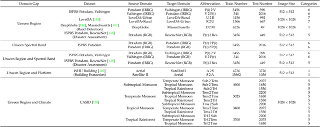

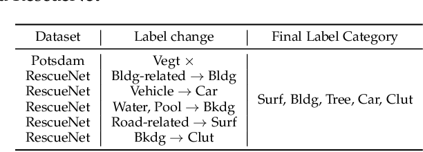
The field of Remote Sensing Domain Generalization (RSDG) has emerged as a critical and valuable research frontier, focusing on developing models that generalize effectively across diverse scenarios. Despite the substantial domain gaps in RS images that are characterized by variabilities such as location, wavelength, and sensor type, research in this area remains underexplored: (1) Current cross-domain methods primarily focus on Domain Adaptation (DA), which adapts models to predefined domains rather than to unseen ones; (2) Few studies targeting the RSDG issue, especially for semantic segmentation tasks, where existing models are developed for specific unknown domains, struggling with issues of underfitting on other unknown scenarios; (3) Existing RS foundation models tend to prioritize in-domain performance over cross-domain generalization. To this end, we introduce the first vision foundation model for RSDG semantic segmentation, CrossEarth. CrossEarth demonstrates strong cross-domain generalization through a specially designed data-level Earth-Style Injection pipeline and a model-level Multi-Task Training pipeline. In addition, for the semantic segmentation task, we have curated an RSDG benchmark comprising 28 cross-domain settings across various regions, spectral bands, platforms, and climates, providing a comprehensive framework for testing the generalizability of future RSDG models. Extensive experiments on this benchmark demonstrate the superiority of CrossEarth over existing state-of-the-art methods.
Extracting polygonal footprints in off-nadir images with Segment Anything Model
Aug 16, 2024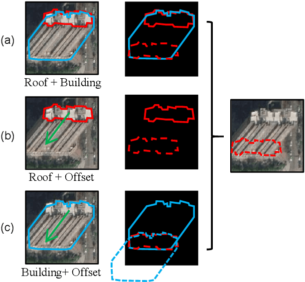
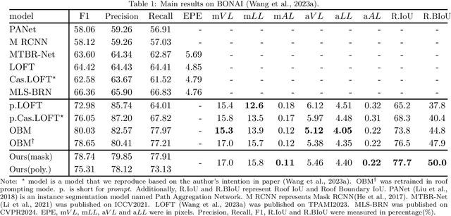
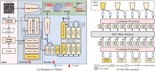

Building Footprint Extraction (BFE) in off-nadir aerial images often relies on roof segmentation and roof-to-footprint offset prediction, then drugging roof-to-footprint via the offset. However, the results from this multi-stage inference are not applicable in data production, because of the low quality of masks given by prediction. To solve this problem, we proposed OBMv2 in this paper, which supports both end-to-end and promptable polygonal footprint prediction. Different from OBM, OBMv2 using a newly proposed Self Offset Attention (SOFA) to bridge the performance gap on bungalow and skyscraper, which realized a real end-to-end footprint polygon prediction without postprocessing. %, such as Non-Maximum Suppression (NMS) and Distance NMS (DNMS). % To fully use information contained in roof masks, building masks and offsets, we proposed a Multi-level Information SyStem (MISS) for footprint prediction, with which OBMv2 can predict footprints even with insufficient predictions. Additionally, to squeeze information from the same model, we were inspired by Retrieval-Augmented Generation (RAG) in Nature Language Processing and proposed "RAG in BFE" problem. To verify the effectiveness of the proposed method, experiments were conducted on open datasets BONAI and OmniCity-view3. A generalization test was also conducted on Huizhou test set. The code will be available at \url{https://github.com/likaiucas/OBM}.
Open-CD: A Comprehensive Toolbox for Change Detection
Jul 22, 2024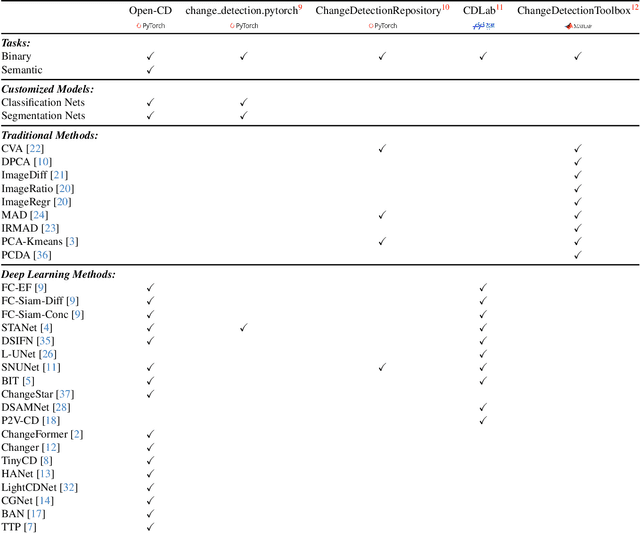

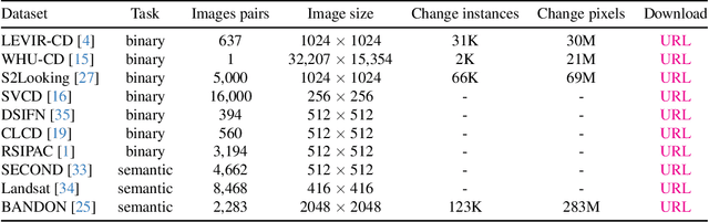

We present Open-CD, a change detection toolbox that contains a rich set of change detection methods as well as related components and modules. The toolbox started from a series of open source general vision task tools, including OpenMMLab Toolkits, PyTorch Image Models, etc. It gradually evolves into a unified platform that covers many popular change detection methods and contemporary modules. It not only includes training and inference codes, but also provides some useful scripts for data analysis. We believe this toolbox is by far the most complete change detection toolbox. In this report, we introduce the various features, supported methods and applications of Open-CD. In addition, we also conduct a benchmarking study on different methods and components. We wish that the toolbox and benchmark could serve the growing research community by providing a flexible toolkit to reimplement existing methods and develop their own new change detectors. Code and models are available at \url{https://github.com/likyoo/open-cd}. Pioneeringly, this report also includes brief descriptions of the algorithms supported in Open-CD, mainly contributed by their authors. We sincerely encourage researchers in this field to participate in this project and work together to create a more open community. This toolkit and report will be kept updated.
DiffMatch: Visual-Language Guidance Makes Better Semi-supervised Change Detector
May 08, 2024Change Detection (CD) aims to identify pixels with semantic changes between images. However, annotating massive numbers of pixel-level images is labor-intensive and costly, especially for multi-temporal images, which require pixel-wise comparisons by human experts. Considering the excellent performance of visual language models (VLMs) for zero-shot, open-vocabulary, etc. with prompt-based reasoning, it is promising to utilize VLMs to make better CD under limited labeled data. In this paper, we propose a VLM guidance-based semi-supervised CD method, namely DiffMatch. The insight of DiffMatch is to synthesize free change labels using VLMs to provide additional supervision signals for unlabeled data. However, almost all current VLMs are designed for single-temporal images and cannot be directly applied to bi- or multi-temporal images. Motivated by this, we first propose a VLM-based mixed change event generation (CEG) strategy to yield pseudo labels for unlabeled CD data. Since the additional supervised signals provided by these VLM-driven pseudo labels may conflict with the pseudo labels from the consistency regularization paradigm (e.g. FixMatch), we propose the dual projection head for de-entangling different signal sources. Further, we explicitly decouple the bi-temporal images semantic representation through two auxiliary segmentation decoders, which are also guided by VLM. Finally, to make the model more adequately capture change representations, we introduce metric-aware supervision by feature-level contrastive loss in auxiliary branches. Extensive experiments show the advantage of DiffMatch. For instance, DiffMatch improves the FixMatch baseline by +5.3 IoU on WHU-CD and by +2.4 IoU on LEVIR-CD with 5% labels. In addition, our CEG strategy, in an un-supervised manner, can achieve performance far superior to state-of-the-art un-supervised CD methods.