 Add to Chrome
 Add to Firefox
 Add to Edge
ObliCity: A Benchmark and Baseline for Roof-to-Ground Projection Displacement Correction
Jul 28, 2026
Oblique-view urban remote sensing imagery inevitably exhibits geometric projection displacements between building roofs and footprints, leading to significant distortions in spatial structure. Existing approaches either ignore these deformations or handle them implicitly within segmentation-based frameworks, where progress is dominated by general segmentation advances rather than improvements in geometric correction. In this work, we explicitly define roof-to-footprint offset vector (RFOV) extraction as an independent learning task that decouples geometric alignment from semantic segmentation. To support this task, we introduce the Oblique City dataset (ObliCity), the first large-scale benchmark that integrates high-resolution UAV imagery and globally distributed satellite data, covering diverse city morphologies and camera perspectives. Methodologically, we reformulate DragOSM into DragRoof, an ODE-based framework inspired by human annotation behavior. By simulating the continuous process of dragging roofs toward their footprints, DragRoof learns deterministic, geometry-consistent offset fields and adaptively determines convergence through an end token. Extensive experiments on ObliCity demonstrate that DragRoof achieves state-of-the-art RFOV extraction performance, requiring fewer inference steps while delivering superior directional and length accuracy. Our dataset and model establish a principled foundation for studying projection displacement correction in oblique remote sensing imagery. The source code and dataset will be avaliable at https://github.com/likaiucas/DragRoof.

GLD-Road:A global-local decoding road network extraction model for remote sensing images
Jun 11, 2025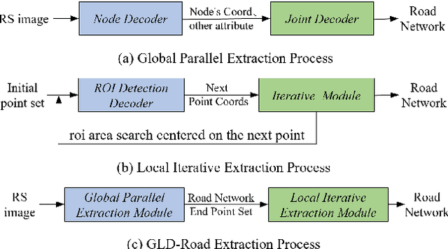
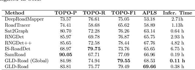
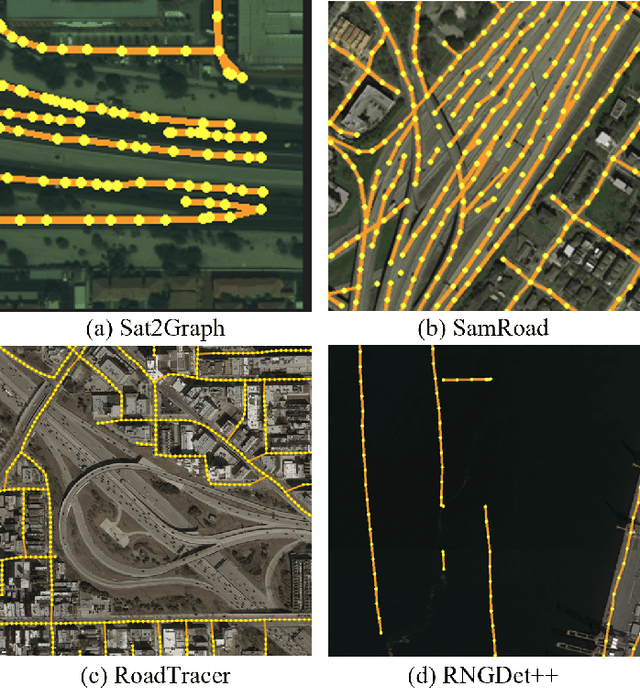
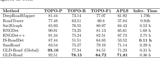
Road networks are crucial for mapping, autonomous driving, and disaster response. While manual annotation is costly, deep learning offers efficient extraction. Current methods include postprocessing (prone to errors), global parallel (fast but misses nodes), and local iterative (accurate but slow). We propose GLD-Road, a two-stage model combining global efficiency and local precision. First, it detects road nodes and connects them via a Connect Module. Then, it iteratively refines broken roads using local searches, drastically reducing computation. Experiments show GLD-Road outperforms state-of-the-art methods, improving APLS by 1.9% (City-Scale) and 0.67% (SpaceNet3). It also reduces retrieval time by 40% vs. Sat2Graph (global) and 92% vs. RNGDet++ (local). The experimental results are available at https://github.com/ucas-dlg/GLD-Road.