 Add to Chrome
 Add to Firefox
 Add to Edge
GESTO: Human-Centric Spatio-Temporal Memory for Reasoning in Dynamic Scenes
Aug 11, 2026
Robots operating in human environments need memories that capture not only what objects exist and where, but also how people use them over time and how individual interactions compose into goal-directed activities. Existing 4D scene graphs preserve object and place histories but omit activity structure, whereas activity representations are either not grounded in persistent 3D scenes or rely on externally provided event boundaries and object associations. We present GESTO (Grounded Event and Spatio-Temporal memOry), a spatio-temporal memory that couples a persistent 4D scene graph with a two-level hierarchy of atomic human--object interactions and goal-driven events. From an RGB-D observation stream, GESTO automatically extracts timestamped interactions, grounds them to persistent scene entities, groups them into events, and uses event context to refine uncertain object associations. A relation-aware tool-calling agent queries the resulting memory for activity-centric spatio-temporal reasoning. We evaluate GESTO on the reproducible text, binary, and time categories of an existing benchmark, together with 40 new Space2Event and Event2Space queries. GESTO achieves scores of 0.71, 0.75, and 0.70 on the standard categories, approaching a method supplied with ground-truth event and object grounding, while substantially outperforming the same reasoning framework when these inputs are removed. It further achieves 0.73 and 0.75 on Space2Event and Event2Space queries. Ablations show that hierarchical event structure and context-aware grounding refinement provide complementary benefits, supporting activity-grounded hierarchical memory for retrospective reasoning in dynamic human environments.

Temporal Overlapping Prediction: A Self-supervised Pre-training Method for LiDAR Moving Object Segmentation
Mar 10, 2025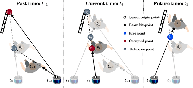
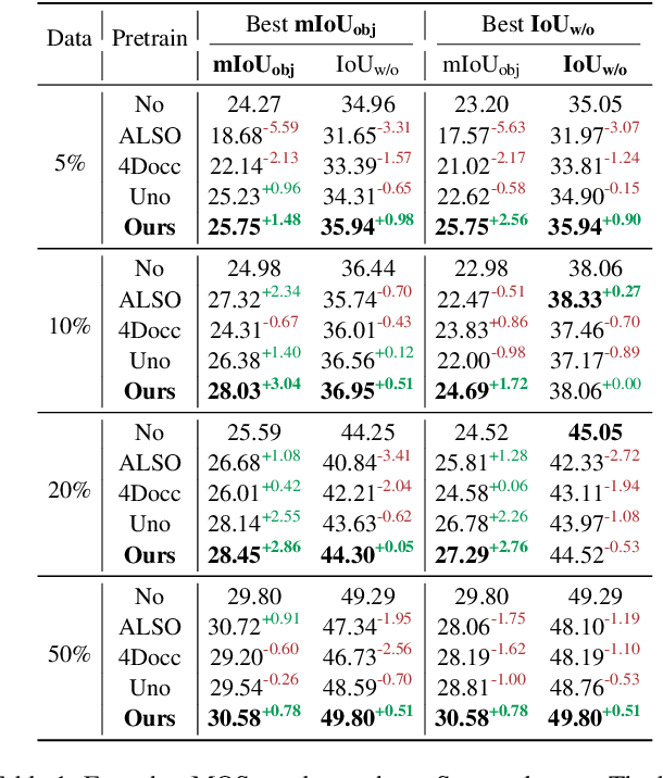
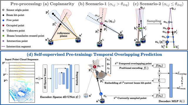
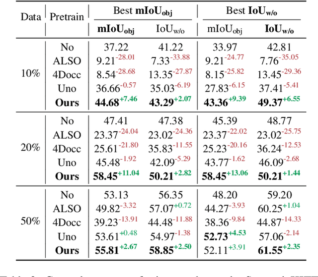
Moving object segmentation (MOS) on LiDAR point clouds is crucial for autonomous systems like self-driving vehicles. Previous supervised approaches rely heavily on costly manual annotations, while LiDAR sequences naturally capture temporal motion cues that can be leveraged for self-supervised learning. In this paper, we propose \textbf{T}emporal \textbf{O}verlapping \textbf{P}rediction (\textbf{TOP}), a self-supervised pre-training method that alleviate the labeling burden for MOS. \textbf{TOP} explores the temporal overlapping points that commonly observed by current and adjacent scans, and learns spatiotemporal representations by predicting the occupancy states of temporal overlapping points. Moreover, we utilize current occupancy reconstruction as an auxiliary pre-training objective, which enhances the current structural awareness of the model. We conduct extensive experiments and observe that the conventional metric Intersection-over-Union (IoU) shows strong bias to objects with more scanned points, which might neglect small or distant objects. To compensate for this bias, we introduce an additional metric called $\text{mIoU}_{\text{obj}}$ to evaluate object-level performance. Experiments on nuScenes and SemanticKITTI show that \textbf{TOP} outperforms both supervised training-from-scratch baseline and other self-supervised pre-training baselines by up to 28.77\% relative improvement, demonstrating strong transferability across LiDAR setups and generalization to other tasks. Code and pre-trained models will be publicly available upon publication.
Coarse-to-fine Hybrid 3D Mapping System with Co-calibrated Omnidirectional Camera and Non-repetitive LiDAR
Feb 08, 2023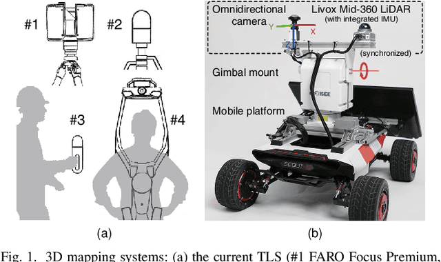
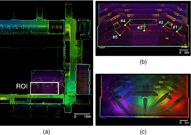
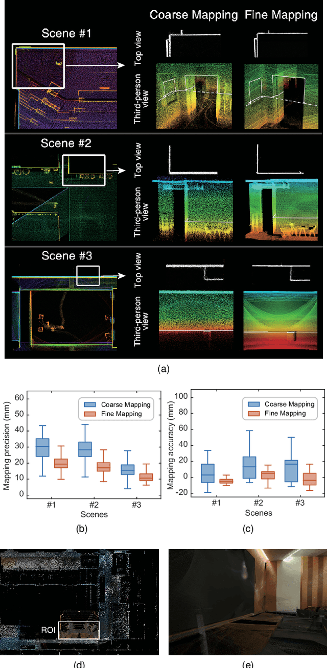
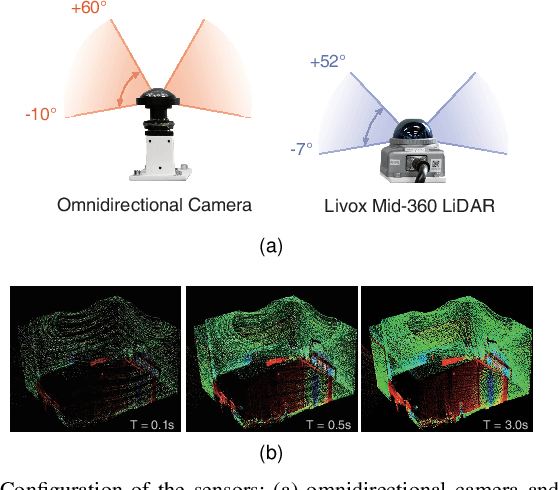
This paper presents a novel 3D mapping robot with an omnidirectional field-of-view (FoV) sensor suite composed of a non-repetitive LiDAR and an omnidirectional camera. Thanks to the non-repetitive scanning nature of the LiDAR, an automatic targetless co-calibration method is proposed to simultaneously calibrate the intrinsic parameters for the omnidirectional camera and the extrinsic parameters for the camera and LiDAR, which is crucial for the required step in bringing color and texture information to the point clouds in surveying and mapping tasks. Comparisons and analyses are made to target-based intrinsic calibration and mutual information (MI)-based extrinsic calibration, respectively. With this co-calibrated sensor suite, the hybrid mapping robot integrates both the odometry-based mapping mode and stationary mapping mode. Meanwhile, we proposed a new workflow to achieve coarse-to-fine mapping, including efficient and coarse mapping in a global environment with odometry-based mapping mode; planning for viewpoints in the region-of-interest (ROI) based on the coarse map (relies on the previous work); navigating to each viewpoint and performing finer and more precise stationary scanning and mapping of the ROI. The fine map is stitched with the global coarse map, which provides a more efficient and precise result than the conventional stationary approaches and the emerging odometry-based approaches, respectively.