 Add to Chrome
 Add to Firefox
 Add to Edge
ST-LoRA: Single Trajectory LoRA Ensemble for Uncertainty Aware Agricultural Segmentation
Aug 02, 2026
Reliable decision-support in digital agriculture requires accurate predictions and well-calibrated uncertainty estimates, particularly for dense prediction tasks such as semantic segmentation. Ensemble methods provide strong uncertainty quantification, but their computational and memory demands limit practical use, while single-model approximations often trade off uncertainty quality for efficiency. We propose ST-LoRA, a parameter-efficient ensemble framework that builds diverse ensemble members from a single training trajectory by combining Low-Rank Adaptation (LoRA) with snapshot ensembling. Each member shares a frozen pretrained backbone and differs only in lightweight low-rank adapters, reducing trainable parameters to under 10% of the full model while preserving ensemble diversity. We evaluate across two agricultural datasets - GrowliFlower-L (cauliflower, open field) and BUP20 (sweet pepper, glasshouse) - using SegFormer and Mask2Former, covering in-distribution performance, calibration under distribution shift, and out-of-distribution detection. Ablations show feed-forward layers, not attention layers, are the critical LoRA target for dense prediction, contrary to the attention-only convention from language models. ST-LoRA matches or exceeds full-rank ensembles in segmentation accuracy and calibration across both datasets and architectures, while substantially reducing training time, inference latency, memory footprint, and storage requirements. Against efficient baselines - Snapshot Ensemble, MC Dropout, and Deep Deterministic Uncertainty - ST-LoRA consistently matches or outperforms them in image/pixel-level OoD detection, calibration stability under shift, and cross-seed variance, with far fewer parameters and lower compute. These results show LoRA-efficient ensemble adaptation is a highly effective, practical approach for uncertainty-aware agricultural vision systems.

Forecasting the Number of Harvest-ready Fruits of Sweet Peppers Using Multimodal Time-Series Data
Jul 22, 2026Accurate yield forecasting at the individual-plant level is critical for precision agriculture and supply-chain planning, yet public datasets capturing both visual growth dynamics and per-plant measurement labels are scarce. In this paper, we introduce a novel, annotated image time-series dataset of 691 sweet pepper plants monitored over two growing seasons, comprising 4837 images with per-plant fruit counts categorized by maturity. We propose a multimodal deep learning framework that fuses high-dimensional image features, extracted using the DinoV3 encoder, with numerical count measurements. Our architecture utilizes a Long Short-Term Memory (LSTM) network to model temporal dependencies and handles irregular sampling intervals common in greenhouse monitoring. Through quantitative experiments, we demonstrate that this multimodal approach reduces RMSE over a persistence baseline by 33% and 38% in the 2022 and 2023 seasons, respectively, with a further 1.2% average gain over a measurement-only model. Furthermore, we employ Deep Ensembles and Gaussian Negative Log-Likelihood (NLL) to provide calibrated uncertainty estimates, with an Uncertainty Calibration Error (UCE) ranging from 0.39 to 0.89 depending on the cross-season evaluation direction, offering a principled confidence signal for real-world agricultural decision-making. We release the dataset and code to support reproducible research and to accelerate development of data-driven yield forecasting methods for horticultural crops.
Still image and spatial-temporal tomato data enabling detection, segmentation, tracking, and video-instance segmentation using strong and weak labels
Jul 16, 2026In this manuscript we release two datasets for visual sensing of tomato plants grown in commercial-like settings and acquired using a robot. The first is BUTom21 which consists of still images and manual annotations. The second is BUTom-ST21 which consists of video-based data and semi-automated annotations through AI-based methods, referred to as pseudo-labels. In both cases, we provide pixel-level labels for the ripeness of the fruit. The aim is to provide the research community a challenging set of real-world imagery to explore methods to sense and estimate the state of tomato plants and their fruit, which is an important horticultural crop. Importantly, the spatial-temporal dataset provides individual fruit count and ripeness information enabling researchers to push the boundaries of field-based phenotyping.
An assessment of data-centric methods for label noise identification in remote sensing data sets
Mar 17, 2026Label noise in the sense of incorrect labels is present in many real-world data sets and is known to severely limit the generalizability of deep learning models. In the field of remote sensing, however, automated treatment of label noise in data sets has received little attention to date. In particular, there is a lack of systematic analysis of the performance of data-centric methods that not only cope with label noise but also explicitly identify and isolate noisy labels. In this paper, we examine three such methods and evaluate their behavior under different label noise assumptions. To do this, we inject different types of label noise with noise levels ranging from 10 to 70% into two benchmark data sets, followed by an analysis of how well the selected methods filter the label noise and how this affects task performances. With our analyses, we clearly prove the value of data-centric methods for both parts - label noise identification and task performance improvements. Our analyses provide insights into which method is the best choice depending on the setting and objective. Finally, we show in which areas there is still a need for research in the transfer of data-centric label noise methods to remote sensing data. As such, our work is a step forward in bridging the methodological establishment of data-centric label noise methods and their usage in practical settings in the remote sensing domain.
LC-SLab -- An Object-based Deep Learning Framework for Large-scale Land Cover Classification from Satellite Imagery and Sparse In-situ Labels
Sep 19, 2025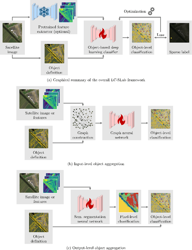
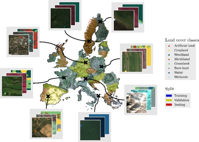
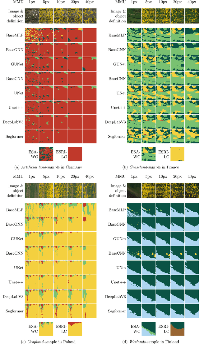
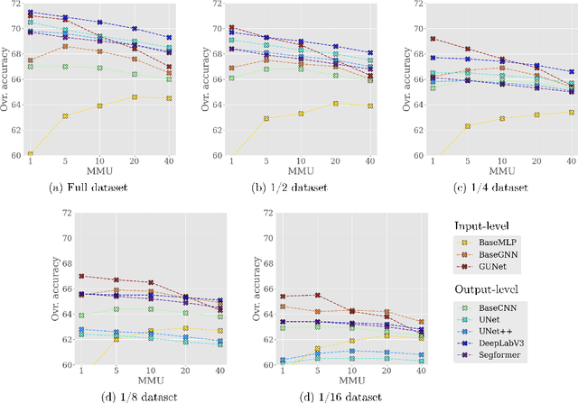
Large-scale land cover maps generated using deep learning play a critical role across a wide range of Earth science applications. Open in-situ datasets from principled land cover surveys offer a scalable alternative to manual annotation for training such models. However, their sparse spatial coverage often leads to fragmented and noisy predictions when used with existing deep learning-based land cover mapping approaches. A promising direction to address this issue is object-based classification, which assigns labels to semantically coherent image regions rather than individual pixels, thereby imposing a minimum mapping unit. Despite this potential, object-based methods remain underexplored in deep learning-based land cover mapping pipelines, especially in the context of medium-resolution imagery and sparse supervision. To address this gap, we propose LC-SLab, the first deep learning framework for systematically exploring object-based deep learning methods for large-scale land cover classification under sparse supervision. LC-SLab supports both input-level aggregation via graph neural networks, and output-level aggregation by postprocessing results from established semantic segmentation models. Additionally, we incorporate features from a large pre-trained network to improve performance on small datasets. We evaluate the framework on annual Sentinel-2 composites with sparse LUCAS labels, focusing on the tradeoff between accuracy and fragmentation, as well as sensitivity to dataset size. Our results show that object-based methods can match or exceed the accuracy of common pixel-wise models while producing substantially more coherent maps. Input-level aggregation proves more robust on smaller datasets, whereas output-level aggregation performs best with more data. Several configurations of LC-SLab also outperform existing land cover products, highlighting the framework's practical utility.
BuzzSet v1.0: A Dataset for Pollinator Detection in Field Conditions
Aug 27, 2025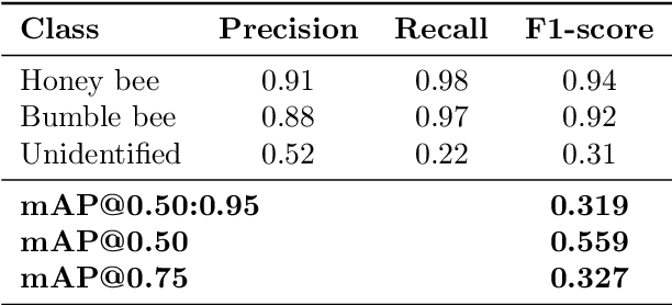
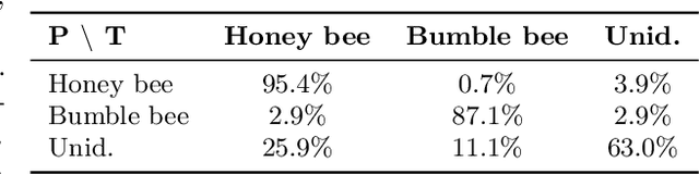
Pollinator insects such as honeybees and bumblebees are vital to global food production and ecosystem stability, yet their populations are declining due to increasing anthropogenic and environmental stressors. To support scalable, automated pollinator monitoring, we introduce BuzzSet, a new large-scale dataset of high-resolution pollinator images collected in real agricultural field conditions. BuzzSet contains 7856 manually verified and labeled images, with over 8000 annotated instances across three classes: honeybees, bumblebees, and unidentified insects. Initial annotations were generated using a YOLOv12 model trained on external data and refined via human verification using open-source labeling tools. All images were preprocessed into 256~$\times$~256 tiles to improve the detection of small insects. We provide strong baselines using the RF-DETR transformer-based object detector. The model achieves high F1-scores of 0.94 and 0.92 for honeybee and bumblebee classes, respectively, with confusion matrix results showing minimal misclassification between these categories. The unidentified class remains more challenging due to label ambiguity and lower sample frequency, yet still contributes useful insights for robustness evaluation. Overall detection quality is strong, with a best mAP@0.50 of 0.559. BuzzSet offers a valuable benchmark for small object detection, class separation under label noise, and ecological computer vision.
Confidence-Filtered Relevance (CFR): An Interpretable and Uncertainty-Aware Machine Learning Framework for Naturalness Assessment in Satellite Imagery
Jul 17, 2025Protected natural areas play a vital role in ecological balance and ecosystem services. Monitoring these regions at scale using satellite imagery and machine learning is promising, but current methods often lack interpretability and uncertainty-awareness, and do not address how uncertainty affects naturalness assessment. In contrast, we propose Confidence-Filtered Relevance (CFR), a data-centric framework that combines LRP Attention Rollout with Deep Deterministic Uncertainty (DDU) estimation to analyze how model uncertainty influences the interpretability of relevance heatmaps. CFR partitions the dataset into subsets based on uncertainty thresholds, enabling systematic analysis of how uncertainty shapes the explanations of naturalness in satellite imagery. Applied to the AnthroProtect dataset, CFR assigned higher relevance to shrublands, forests, and wetlands, aligning with other research on naturalness assessment. Moreover, our analysis shows that as uncertainty increases, the interpretability of these relevance heatmaps declines and their entropy grows, indicating less selective and more ambiguous attributions. CFR provides a data-centric approach to assess the relevance of patterns to naturalness in satellite imagery based on their associated certainty.
Core-Set Selection for Data-efficient Land Cover Segmentation
May 02, 2025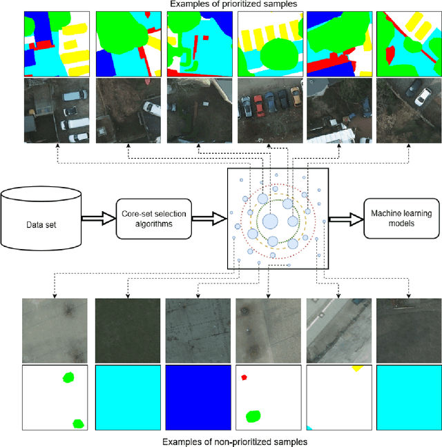
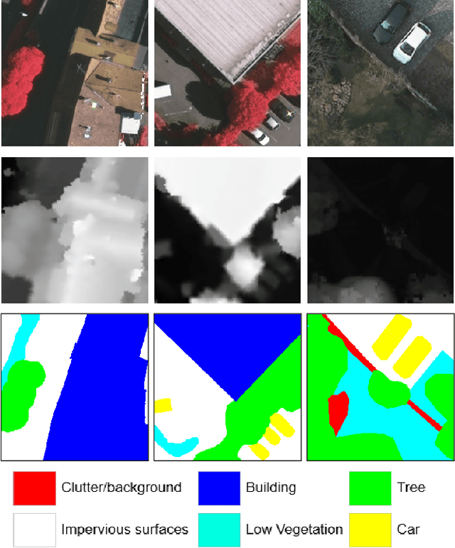
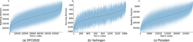
The increasing accessibility of remotely sensed data and the potential of such data to inform large-scale decision-making has driven the development of deep learning models for many Earth Observation tasks. Traditionally, such models must be trained on large datasets. However, the common assumption that broadly larger datasets lead to better outcomes tends to overlook the complexities of the data distribution, the potential for introducing biases and noise, and the computational resources required for processing and storing vast datasets. Therefore, effective solutions should consider both the quantity and quality of data. In this paper, we propose six novel core-set selection methods for selecting important subsets of samples from remote sensing image segmentation datasets that rely on imagery only, labels only, and a combination of each. We benchmark these approaches against a random-selection baseline on three commonly used land cover classification datasets: DFC2022, Vaihingen, and Potsdam. In each of the datasets, we demonstrate that training on a subset of samples outperforms the random baseline, and some approaches outperform training on all available data. This result shows the importance and potential of data-centric learning for the remote sensing domain. The code is available at https://github.com/keillernogueira/data-centric-rs-classification/.
Explainability of Sub-Field Level Crop Yield Prediction using Remote Sensing
Jul 11, 2024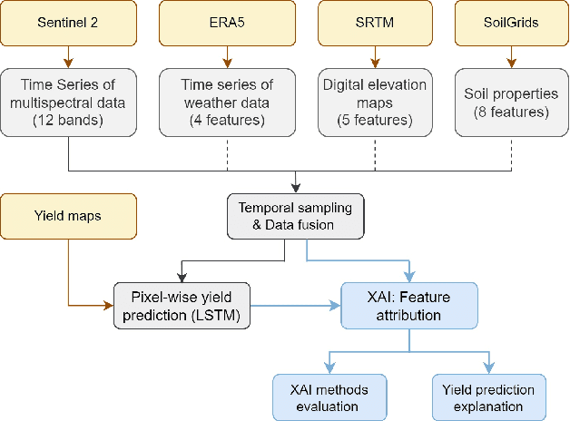
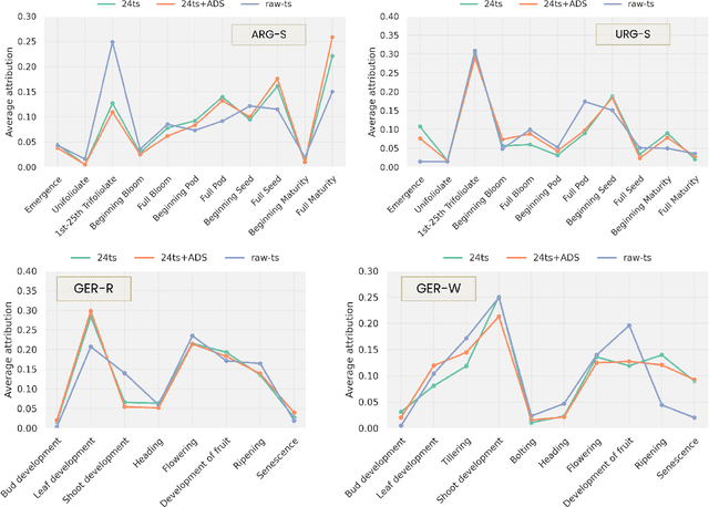
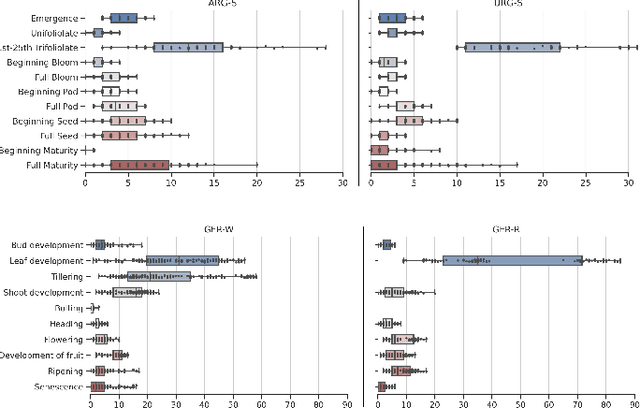
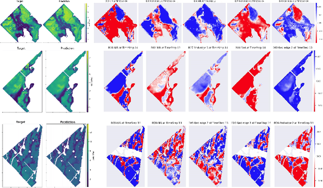
Crop yield forecasting plays a significant role in addressing growing concerns about food security and guiding decision-making for policymakers and farmers. When deep learning is employed, understanding the learning and decision-making processes of the models, as well as their interaction with the input data, is crucial for establishing trust in the models and gaining insight into their reliability. In this study, we focus on the task of crop yield prediction, specifically for soybean, wheat, and rapeseed crops in Argentina, Uruguay, and Germany. Our goal is to develop and explain predictive models for these crops, using a large dataset of satellite images, additional data modalities, and crop yield maps. We employ a long short-term memory network and investigate the impact of using different temporal samplings of the satellite data and the benefit of adding more relevant modalities. For model explainability, we utilize feature attribution methods to quantify input feature contributions, identify critical growth stages, analyze yield variability at the field level, and explain less accurate predictions. The modeling results show an improvement when adding more modalities or using all available instances of satellite data. The explainability results reveal distinct feature importance patterns for each crop and region. We further found that the most influential growth stages on the prediction are dependent on the temporal sampling of the input data. We demonstrated how these critical growth stages, which hold significant agronomic value, closely align with the existing literature in agronomy and crop development biology.
Data-Centric Machine Learning for Geospatial Remote Sensing Data
Dec 08, 2023
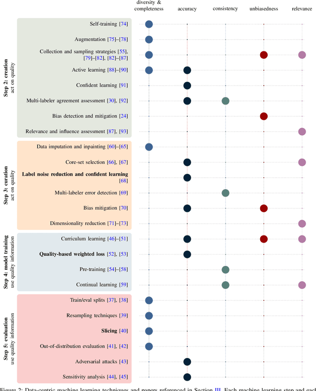
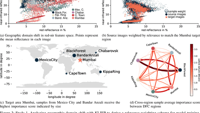
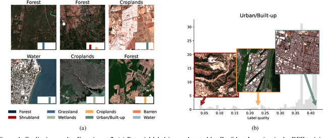
Recent developments and research in modern machine learning have led to substantial improvements in the geospatial field. Although numerous deep learning models have been proposed, the majority of them have been developed on benchmark datasets that lack strong real-world relevance. Furthermore, the performance of many methods has already saturated on these datasets. We argue that shifting the focus towards a complementary data-centric perspective is necessary to achieve further improvements in accuracy, generalization ability, and real impact in end-user applications. This work presents a definition and precise categorization of automated data-centric learning approaches for geospatial data. It highlights the complementary role of data-centric learning with respect to model-centric in the larger machine learning deployment cycle. We review papers across the entire geospatial field and categorize them into different groups. A set of representative experiments shows concrete implementation examples. These examples provide concrete steps to act on geospatial data with data-centric machine learning approaches.