 Add to Chrome
 Add to Firefox
 Add to Edge
LC-SLab -- An Object-based Deep Learning Framework for Large-scale Land Cover Classification from Satellite Imagery and Sparse In-situ Labels
Sep 19, 2025


Large-scale land cover maps generated using deep learning play a critical role across a wide range of Earth science applications. Open in-situ datasets from principled land cover surveys offer a scalable alternative to manual annotation for training such models. However, their sparse spatial coverage often leads to fragmented and noisy predictions when used with existing deep learning-based land cover mapping approaches. A promising direction to address this issue is object-based classification, which assigns labels to semantically coherent image regions rather than individual pixels, thereby imposing a minimum mapping unit. Despite this potential, object-based methods remain underexplored in deep learning-based land cover mapping pipelines, especially in the context of medium-resolution imagery and sparse supervision. To address this gap, we propose LC-SLab, the first deep learning framework for systematically exploring object-based deep learning methods for large-scale land cover classification under sparse supervision. LC-SLab supports both input-level aggregation via graph neural networks, and output-level aggregation by postprocessing results from established semantic segmentation models. Additionally, we incorporate features from a large pre-trained network to improve performance on small datasets. We evaluate the framework on annual Sentinel-2 composites with sparse LUCAS labels, focusing on the tradeoff between accuracy and fragmentation, as well as sensitivity to dataset size. Our results show that object-based methods can match or exceed the accuracy of common pixel-wise models while producing substantially more coherent maps. Input-level aggregation proves more robust on smaller datasets, whereas output-level aggregation performs best with more data. Several configurations of LC-SLab also outperform existing land cover products, highlighting the framework's practical utility.
Data-driven Crop Growth Simulation on Time-varying Generated Images using Multi-conditional Generative Adversarial Networks
Dec 06, 2023Image-based crop growth modeling can substantially contribute to precision agriculture by revealing spatial crop development over time, which allows an early and location-specific estimation of relevant future plant traits, such as leaf area or biomass. A prerequisite for realistic and sharp crop image generation is the integration of multiple growth-influencing conditions in a model, such as an image of an initial growth stage, the associated growth time, and further information about the field treatment. We present a two-stage framework consisting first of an image prediction model and second of a growth estimation model, which both are independently trained. The image prediction model is a conditional Wasserstein generative adversarial network (CWGAN). In the generator of this model, conditional batch normalization (CBN) is used to integrate different conditions along with the input image. This allows the model to generate time-varying artificial images dependent on multiple influencing factors of different kinds. These images are used by the second part of the framework for plant phenotyping by deriving plant-specific traits and comparing them with those of non-artificial (real) reference images. For various crop datasets, the framework allows realistic, sharp image predictions with a slight loss of quality from short-term to long-term predictions. Simulations of varying growth-influencing conditions performed with the trained framework provide valuable insights into how such factors relate to crop appearances, which is particularly useful in complex, less explored crop mixture systems. Further results show that adding process-based simulated biomass as a condition increases the accuracy of the derived phenotypic traits from the predicted images. This demonstrates the potential of our framework to serve as an interface between an image- and process-based crop growth model.
Exploring Wilderness Using Explainable Machine Learning in Satellite Imagery
Apr 11, 2022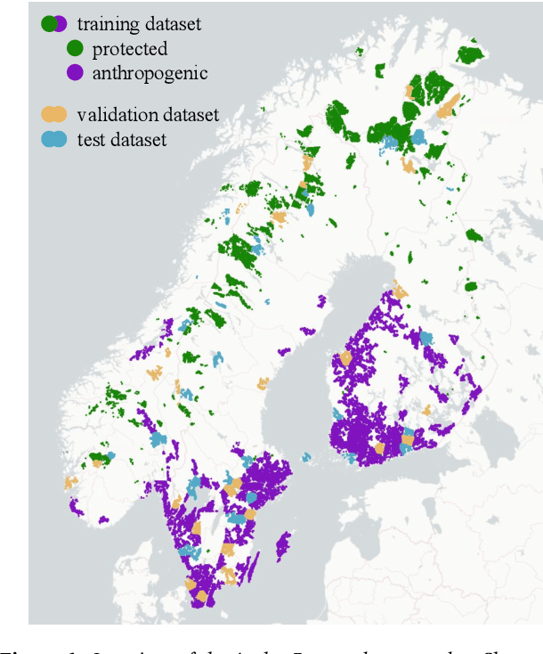
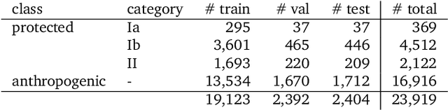
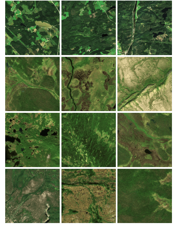
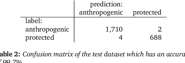
Wilderness areas offer important ecological and social benefits and therefore warrant monitoring and preservation. Yet, the characteristics of wilderness are little known, making the detection and monitoring of wilderness areas via remote sensing techniques a challenging task. We explore the appearance and characteristics of the vague concept of wilderness via multispectral satellite imagery. For this, we apply a novel explainable machine learning technique to a dataset consisting of wild and anthropogenic areas in Fennoscandia. With our technique, we predict continuous, detailed, and high-resolution sensitivity maps of unseen remote sensing data for wild and anthropogenic characteristics. Our neural network provides an interpretable activation space in which regions are semantically arranged regarding these characteristics and certain land cover classes. Interpretability increases confidence in the method and allows for new explanations of the investigated concept. Our model advances explainable machine learning for remote sensing, offers opportunities for comprehensive analyses of existing wilderness, and has practical relevance for conservation efforts.