 Add to Chrome
 Add to Firefox
 Add to Edge
EarthShift: a benchmark for measuring robustness to real-world distribution shifts in Earth observation
May 28, 2026Current Earth observation benchmarks focus on measuring performance on diverse tasks and applications, typically measuring generalization in-distribution. But when models are deployed, they must generalize to myriad out-of-distribution scenarios, such as new time periods, geographies, scales, and sensors. We introduce EarthShift: the first public testbed for benchmarking robustness across multiple realistic distribution shifts encountered in remote sensing. EarthShift enables users to measure distributional robustness by comparing performance in- and out-of-distribution using datasets from paired datasets from different sources, temporal windows, geographic locations, and sensors. Our experiments on 8 geospatial foundation models (GFMs) and 11 tasks covering 5 shift types show that GFMs consistently perform 15-20% worse out-of-distribution on average regardless of model architecture, size, pre-training or fine-tuning strategy. We show that GFM robustness is similar to that of generic vision foundation models, and even fully-supervised models. This highlights a need for future research to strive for improvements in distributional robustness, not just performance, which can be benchmarked using EarthShift. We release our code and datasets to provide a testbed to guide future work to create foundation models that are robust and reliable in real-world applications. Code and data for EarthShift are available at: https://earthshift.github.io
No One Knows the State of the Art in Geospatial Foundation Models
May 12, 2026Geospatial foundation models (GFMs) have been proposed as generalizable backbones for disaster response, land-cover mapping, food-security monitoring, and other high-stakes Earth-observation tasks. Yet the published work about these models does not give reviewers or users enough information to tell which model fits a given task. We argue that nobody knows what the current state of the art is in geospatial foundation models. The methods may be useful, but the GFM literature does not standardize evaluations, training and testing protocols, released weights, or pretraining controls well enough for anyone to compare or rank them. In a 152-paper audit, we find 46 cross-paper disagreements of at least 10 points for the same model, benchmark, and protocol; 94/126 papers with extractable pretraining data use a configuration no other paper uses; and 39% of GFM papers release no model weights. This lack of community standards can be solved. We propose six concrete expectations: named-license weight release, shared core evaluations, copied-versus-rerun baseline annotations, variance reporting, one shared evaluation harness, and data-vs-architecture-vs-algorithm controls. These gaps are a coordination failure, not a fault of any individual lab; the authors of this paper, like many others in the GFM community, have contributed to them. Rather than just critiquing the community, we aim to provide concrete steps toward a shared understanding of how to innovate GFMs.
Pretrain Where? Investigating How Pretraining Data Diversity Impacts Geospatial Foundation Model Performance
Apr 22, 2026New geospatial foundation models introduce a new model architecture and pretraining dataset, often sampled using different notions of data diversity. Performance differences are largely attributed to the model architecture or input modalities, while the role of the pretraining dataset is rarely studied. To address this research gap, we conducted a systematic study on how the geographic composition of pretraining data affects a model's downstream performance. We created global and per-continent pretraining datasets and evaluated them on global and per-continent downstream datasets. We found that the pretraining dataset from Europe outperformed global and continent-specific pretraining datasets on both global and local downstream evaluations. To investigate the factors influencing a pretraining dataset's downstream performance, we analysed 10 pretraining datasets using diversity across continents, biomes, landcover and spectral values. We found that only spectral diversity was strongly correlated with performance, while others were weakly correlated. This finding establishes a new dimension of diversity to be accounted for when creating a high-performing pretraining dataset. We open-sourced 7 new pretraining datasets, pretrained models, and our experimental framework at https://github.com/kerner-lab/pretrain-where.
MOMO: Mars Orbital Model Foundation Model for Mars Orbital Applications
Apr 03, 2026We introduce MOMO, the first multi-sensor foundation model for Mars remote sensing. MOMO uses model merge to integrate representations learned independently from three key Martian sensors (HiRISE, CTX, and THEMIS), spanning resolutions from 0.25 m/pixel to 100 m/pixel. Central to our method is our novel Equal Validation Loss (EVL) strategy, which aligns checkpoints across sensors based on validation loss similarity before fusion via task arithmetic. This ensures models are merged at compatible convergence stages, leading to improved stability and generalization. We train MOMO on a large-scale, high-quality corpus of $\sim 12$ million samples curated from Mars orbital data and evaluate it on 9 downstream tasks from Mars-Bench. MOMO achieves better overall performance compared to ImageNet pre-trained, earth observation foundation model, sensor-specific pre-training, and fully-supervised baselines. Particularly on segmentation tasks, MOMO shows consistent and significant performance improvement. Our results demonstrate that model merging through an optimal checkpoint selection strategy provides an effective approach for building foundation models for multi-resolution data. The model weights, pretraining code, pretraining data, and evaluation code are available at: https://github.com/kerner-lab/MOMO.
PRUE: A Practical Recipe for Field Boundary Segmentation at Scale
Mar 28, 2026Large-scale maps of field boundaries are essential for agricultural monitoring tasks. Existing deep learning approaches for satellite-based field mapping are sensitive to illumination, spatial scale, and changes in geographic location. We conduct the first systematic evaluation of segmentation and geospatial foundation models (GFMs) for global field boundary delineation using the Fields of The World (FTW) benchmark. We evaluate 18 models under unified experimental settings, showing that a U-Net semantic segmentation model outperforms instance-based and GFM alternatives on a suite of performance and deployment metrics. We propose a new segmentation approach that combines a U-Net backbone, composite loss functions, and targeted data augmentations to enhance performance and robustness under real-world conditions. Our model achieves a 76\% IoU and 47\% object-F1 on FTW, an increase of 6\% and 9\% over the previous baseline. Our approach provides a practical framework for reliable, scalable, and reproducible field boundary delineation across model design, training, and inference. We release all models and model-derived field boundary datasets for five countries.
Fields of The World: A Field Guide for Extracting Agricultural Field Boundaries
Feb 08, 2026Field boundary maps are a building block for agricultural data products and support crop monitoring, yield estimation, and disease estimation. This tutorial presents the Fields of The World (FTW) ecosystem: a benchmark of 1.6M field polygons across 24 countries, pre-trained segmentation models, and command-line inference tools. We provide two notebooks that cover (1) local-scale field boundary extraction with crop classification and forest loss attribution, and (2) country-scale inference using cloud-optimized data. We use MOSAIKS random convolutional features and FTW derived field boundaries to map crop type at the field level and report macro F1 scores of 0.65--0.75 for crop type classification with limited labels. Finally, we show how to explore pre-computed predictions over five countries (4.76M km\textsuperscript{2}), with median predicted field areas from 0.06 ha (Rwanda) to 0.28 ha (Switzerland).
Multi-Head LatentMoE and Head Parallel: Communication-Efficient and Deterministic MoE Parallelism
Feb 04, 2026Large language models have transformed many applications but remain expensive to train. Sparse Mixture of Experts (MoE) addresses this through conditional computation, with Expert Parallel (EP) as the standard distributed training method. However, EP has three limitations: communication cost grows linearly with the number of activated experts $k$, load imbalance affects latency and memory usage, and data-dependent communication requires metadata exchange. We propose Multi-Head LatentMoE and Head Parallel (HP), a new architecture and parallelism achieving $O(1)$ communication cost regardless of $k$, completely balanced traffic, and deterministic communication, all while remaining compatible with EP. To accelerate Multi-Head LatentMoE, we propose IO-aware routing and expert computation. Compared to MoE with EP, Multi-Head LatentMoE with HP trains up to $1.61\times$ faster while having identical performance. With doubled granularity, it achieves higher overall performance while still being $1.11\times$ faster. Our method makes multi-billion-parameter foundation model research more accessible.
GEO-Bench-2: From Performance to Capability, Rethinking Evaluation in Geospatial AI
Nov 19, 2025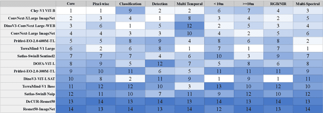


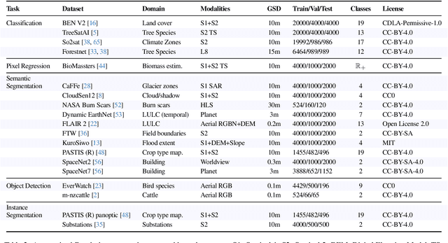
Geospatial Foundation Models (GeoFMs) are transforming Earth Observation (EO), but evaluation lacks standardized protocols. GEO-Bench-2 addresses this with a comprehensive framework spanning classification, segmentation, regression, object detection, and instance segmentation across 19 permissively-licensed datasets. We introduce ''capability'' groups to rank models on datasets that share common characteristics (e.g., resolution, bands, temporality). This enables users to identify which models excel in each capability and determine which areas need improvement in future work. To support both fair comparison and methodological innovation, we define a prescriptive yet flexible evaluation protocol. This not only ensures consistency in benchmarking but also facilitates research into model adaptation strategies, a key and open challenge in advancing GeoFMs for downstream tasks. Our experiments show that no single model dominates across all tasks, confirming the specificity of the choices made during architecture design and pretraining. While models pretrained on natural images (ConvNext ImageNet, DINO V3) excel on high-resolution tasks, EO-specific models (TerraMind, Prithvi, and Clay) outperform them on multispectral applications such as agriculture and disaster response. These findings demonstrate that optimal model choice depends on task requirements, data modalities, and constraints. This shows that the goal of a single GeoFM model that performs well across all tasks remains open for future research. GEO-Bench-2 enables informed, reproducible GeoFM evaluation tailored to specific use cases. Code, data, and leaderboard for GEO-Bench-2 are publicly released under a permissive license.
OlmoEarth: Stable Latent Image Modeling for Multimodal Earth Observation
Nov 17, 2025Earth observation data presents a unique challenge: it is spatial like images, sequential like video or text, and highly multimodal. We present OlmoEarth: a multimodal, spatio-temporal foundation model that employs a novel self-supervised learning formulation, masking strategy, and loss all designed for the Earth observation domain. OlmoEarth achieves state-of-the-art performance compared to 12 other foundation models across a variety of research benchmarks and real-world tasks from external partners. When evaluating embeddings OlmoEarth achieves the best performance on 15 out of 24 tasks, and with full fine-tuning it is the best on 19 of 29 tasks. We deploy OlmoEarth as the backbone of an end-to-end platform for data collection, labeling, training, and inference of Earth observation models. The OlmoEarth Platform puts frontier foundation models and powerful data management tools into the hands of non-profits and NGOs working to solve the world's biggest problems. OlmoEarth source code, training data, and pre-trained weights are available at $\href{https://github.com/allenai/olmoearth_pretrain}{\text{https://github.com/allenai/olmoearth_pretrain}}$.
DataS^3: Dataset Subset Selection for Specialization
Apr 22, 2025


In many real-world machine learning (ML) applications (e.g. detecting broken bones in x-ray images, detecting species in camera traps), in practice models need to perform well on specific deployments (e.g. a specific hospital, a specific national park) rather than the domain broadly. However, deployments often have imbalanced, unique data distributions. Discrepancy between the training distribution and the deployment distribution can lead to suboptimal performance, highlighting the need to select deployment-specialized subsets from the available training data. We formalize dataset subset selection for specialization (DS3): given a training set drawn from a general distribution and a (potentially unlabeled) query set drawn from the desired deployment-specific distribution, the goal is to select a subset of the training data that optimizes deployment performance. We introduce DataS^3; the first dataset and benchmark designed specifically for the DS3 problem. DataS^3 encompasses diverse real-world application domains, each with a set of distinct deployments to specialize in. We conduct a comprehensive study evaluating algorithms from various families--including coresets, data filtering, and data curation--on DataS^3, and find that general-distribution methods consistently fail on deployment-specific tasks. Additionally, we demonstrate the existence of manually curated (deployment-specific) expert subsets that outperform training on all available data with accuracy gains up to 51.3 percent. Our benchmark highlights the critical role of tailored dataset curation in enhancing performance and training efficiency on deployment-specific distributions, which we posit will only become more important as global, public datasets become available across domains and ML models are deployed in the real world.