 Add to Chrome
 Add to Firefox
 Add to Edge
Post-Hoc Sparse Coding of Latent Communication Between Vision-Language Model Agents
Aug 10, 2026
Latent-space communication allows heterogeneous vision-language model agents to exchange continuous representations without serializing visual and reasoning states into text. Vision Wormhole realizes this approach by translating visual features into a universal latent representation that can be consumed by another model, but every message is transported as a dense tensor of the same size regardless of its content. A fixed-capacity dense tensor therefore need not have a fixed effective information density: some messages may use only a small fraction of the available representational degrees of freedom. This observation suggests that the communication channel may be substantially compressible. We study its redundancy by fitting a post-hoc sparse autoencoder to frozen Vision Wormhole activations and measuring reconstruction, downstream utility, feature reuse, and token-level interventions across nine reasoning benchmarks. Relative to the original float32 transport, a uint16-index/float16-value sparse payload with k=4 active coefficients per token reduces the transmitted bytes by 128x. In a single-run evaluation, the seven-task non-AIME mean accuracy changes from 49.85% to 49.77%. The fitted 4096-element dictionary uses only 50 features, and task-level active sets have a mean pairwise Jaccard similarity of 0.906. These measurements establish strong post-hoc compressibility relative to the original transport, but do not yet isolate the incremental contribution of sparse coding from position selection, reduced precision, low-rank structure, or SAE optimization effects. The results motivate matched-payload comparisons and communication mechanisms whose payload adapts to the information used by each message.

Multimodal Fusion for Fine-Grained Classification of Breast Fibroadenoma and Phyllodes Tumors
Jul 02, 2026Breast fibroadenoma (FA) and phyllodes tumor (PT) are fibroepithelial breast lesions with highly overlapping appearances on B-mode ultrasound, making benign and borderline PT prone to being misclassified as FA and complicating preoperative decision-making. Existing computer-aided diagnosis methods commonly rely on single-modal imaging features and insufficiently exploit complementary clinical and textual information. To address this limitation, we construct the FAPT-M Dataset, a pathology-confirmed multimodal dataset comprising 910 patients with strictly reviewed ultrasound images, structured clinical attributes, and ultrasound diagnostic descriptions. Based on this dataset, we propose a clinically guided multimodal framework that integrates DenseNet-based visual encoding, CLIP-inspired text encoding, and lightweight clinical encoding, and further introduces clinical-conditioned adaptive modulation, cross-modal Transformer fusion, and dual-path representation learning to improve feature alignment and multimodal interaction. Under patient-level five-fold cross-validation, the proposed method achieves an accuracy of 77.64%, F1-score of 73.38%, and AUC of 89.74%, outperforming representative CNN-, Transformer-, and vision-language-based baselines. Ablation studies and class-balanced evaluations further confirm the contribution of three-modality fusion and the key architectural components. Overall, this work provides an effective multimodal approach for fine-grained FA-PT classification and establishes a high-quality benchmark for multimodal breast ultrasound analysis.
WaterVideoQA: ASV-Centric Perception and Rule-Compliant Reasoning via Multi-Modal Agents
Feb 26, 2026While autonomous navigation has achieved remarkable success in passive perception (e.g., object detection and segmentation), it remains fundamentally constrained by a void in knowledge-driven, interactive environmental cognition. In the high-stakes domain of maritime navigation, the ability to bridge the gap between raw visual perception and complex cognitive reasoning is not merely an enhancement but a critical prerequisite for Autonomous Surface Vessels to execute safe and precise maneuvers. To this end, we present WaterVideoQA, the first large-scale, comprehensive Video Question Answering benchmark specifically engineered for all-waterway environments. This benchmark encompasses 3,029 video clips across six distinct waterway categories, integrating multifaceted variables such as volatile lighting and dynamic weather to rigorously stress-test ASV capabilities across a five-tier hierarchical cognitive framework. Furthermore, we introduce NaviMind, a pioneering multi-agent neuro-symbolic system designed for open-ended maritime reasoning. By synergizing Adaptive Semantic Routing, Situation-Aware Hierarchical Reasoning, and Autonomous Self-Reflective Verification, NaviMind transitions ASVs from superficial pattern matching to regulation-compliant, interpretable decision-making. Experimental results demonstrate that our framework significantly transcends existing baselines, establishing a new paradigm for intelligent, trustworthy interaction in dynamic maritime environments.
4D-CAAL: 4D Radar-Camera Calibration and Auto-Labeling for Autonomous Driving
Jan 29, 20264D radar has emerged as a critical sensor for autonomous driving, primarily due to its enhanced capabilities in elevation measurement and higher resolution compared to traditional 3D radar. Effective integration of 4D radar with cameras requires accurate extrinsic calibration, and the development of radar-based perception algorithms demands large-scale annotated datasets. However, existing calibration methods often employ separate targets optimized for either visual or radar modalities, complicating correspondence establishment. Furthermore, manually labeling sparse radar data is labor-intensive and unreliable. To address these challenges, we propose 4D-CAAL, a unified framework for 4D radar-camera calibration and auto-labeling. Our approach introduces a novel dual-purpose calibration target design, integrating a checkerboard pattern on the front surface for camera detection and a corner reflector at the center of the back surface for radar detection. We develop a robust correspondence matching algorithm that aligns the checkerboard center with the strongest radar reflection point, enabling accurate extrinsic calibration. Subsequently, we present an auto-labeling pipeline that leverages the calibrated sensor relationship to transfer annotations from camera-based segmentations to radar point clouds through geometric projection and multi-feature optimization. Extensive experiments demonstrate that our method achieves high calibration accuracy while significantly reducing manual annotation effort, thereby accelerating the development of robust multi-modal perception systems for autonomous driving.
Supervised Visual Docking Network for Unmanned Surface Vehicles Using Auto-labeling in Real-world Water Environments
Mar 05, 2025Unmanned Surface Vehicles (USVs) are increasingly applied to water operations such as environmental monitoring and river-map modeling. It faces a significant challenge in achieving precise autonomous docking at ports or stations, still relying on remote human control or external positioning systems for accuracy and safety which limits the full potential of human-out-of-loop deployment for USVs.This paper introduces a novel supervised learning pipeline with the auto-labeling technique for USVs autonomous visual docking. Firstly, we designed an auto-labeling data collection pipeline that appends relative pose and image pair to the dataset. This step does not require conventional manual labeling for supervised learning. Secondly, the Neural Dock Pose Estimator (NDPE) is proposed to achieve relative dock pose prediction without the need for hand-crafted feature engineering, camera calibration, and peripheral markers. Moreover, The NDPE can accurately predict the relative dock pose in real-world water environments, facilitating the implementation of Position-Based Visual Servo (PBVS) and low-level motion controllers for efficient and autonomous docking.Experiments show that the NDPE is robust to the disturbance of the distance and the USV velocity. The effectiveness of our proposed solution is tested and validated in real-world water environments, reflecting its capability to handle real-world autonomous docking tasks.
ULSR-GS: Ultra Large-scale Surface Reconstruction Gaussian Splatting with Multi-View Geometric Consistency
Dec 02, 2024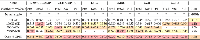
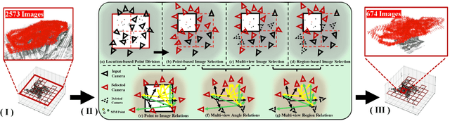
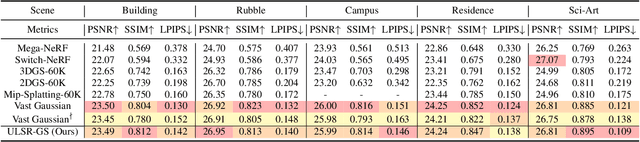
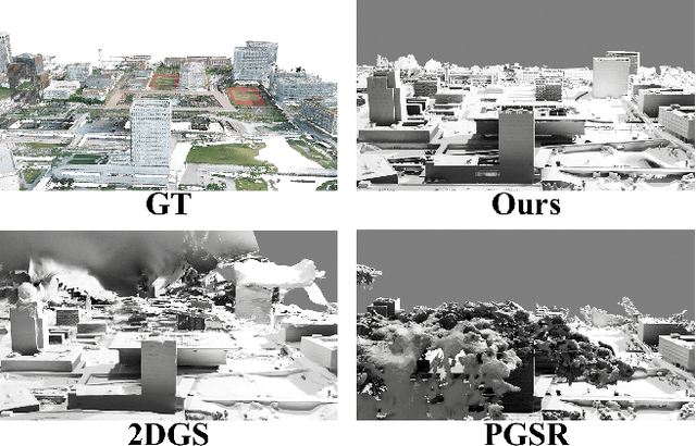
While Gaussian Splatting (GS) demonstrates efficient and high-quality scene rendering and small area surface extraction ability, it falls short in handling large-scale aerial image surface extraction tasks. To overcome this, we present ULSR-GS, a framework dedicated to high-fidelity surface extraction in ultra-large-scale scenes, addressing the limitations of existing GS-based mesh extraction methods. Specifically, we propose a point-to-photo partitioning approach combined with a multi-view optimal view matching principle to select the best training images for each sub-region. Additionally, during training, ULSR-GS employs a densification strategy based on multi-view geometric consistency to enhance surface extraction details. Experimental results demonstrate that ULSR-GS outperforms other state-of-the-art GS-based works on large-scale aerial photogrammetry benchmark datasets, significantly improving surface extraction accuracy in complex urban environments. Project page: https://ulsrgs.github.io.
VMGNet: A Low Computational Complexity Robotic Grasping Network Based on VMamba with Multi-Scale Feature Fusion
Nov 19, 2024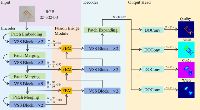
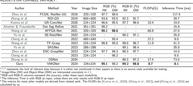
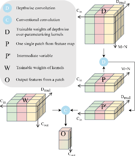
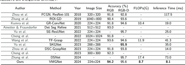
While deep learning-based robotic grasping technology has demonstrated strong adaptability, its computational complexity has also significantly increased, making it unsuitable for scenarios with high real-time requirements. Therefore, we propose a low computational complexity and high accuracy model named VMGNet for robotic grasping. For the first time, we introduce the Visual State Space into the robotic grasping field to achieve linear computational complexity, thereby greatly reducing the model's computational cost. Meanwhile, to improve the accuracy of the model, we propose an efficient and lightweight multi-scale feature fusion module, named Fusion Bridge Module, to extract and fuse information at different scales. We also present a new loss function calculation method to enhance the importance differences between subtasks, improving the model's fitting ability. Experiments show that VMGNet has only 8.7G Floating Point Operations and an inference time of 8.1 ms on our devices. VMGNet also achieved state-of-the-art performance on the Cornell and Jacquard public datasets. To validate VMGNet's effectiveness in practical applications, we conducted real grasping experiments in multi-object scenarios, and VMGNet achieved an excellent performance with a 94.4% success rate in real-world grasping tasks. The video for the real-world robotic grasping experiments is available at https://youtu.be/S-QHBtbmLc4.
NanoMVG: USV-Centric Low-Power Multi-Task Visual Grounding based on Prompt-Guided Camera and 4D mmWave Radar
Aug 30, 2024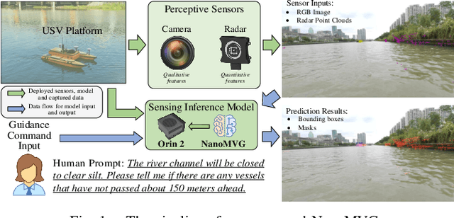

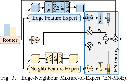
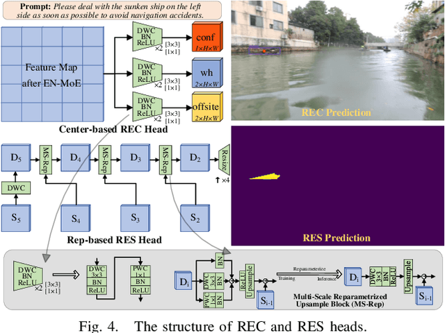
Recently, visual grounding and multi-sensors setting have been incorporated into perception system for terrestrial autonomous driving systems and Unmanned Surface Vehicles (USVs), yet the high complexity of modern learning-based visual grounding model using multi-sensors prevents such model to be deployed on USVs in the real-life. To this end, we design a low-power multi-task model named NanoMVG for waterway embodied perception, guiding both camera and 4D millimeter-wave radar to locate specific object(s) through natural language. NanoMVG can perform both box-level and mask-level visual grounding tasks simultaneously. Compared to other visual grounding models, NanoMVG achieves highly competitive performance on the WaterVG dataset, particularly in harsh environments and boasts ultra-low power consumption for long endurance.
MVG-Splatting: Multi-View Guided Gaussian Splatting with Adaptive Quantile-Based Geometric Consistency Densification
Jul 16, 2024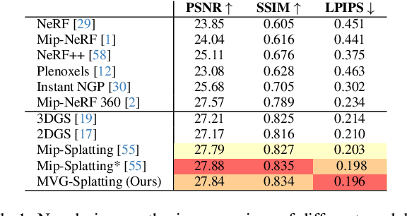
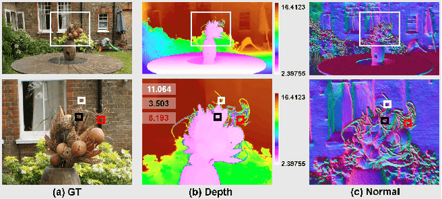

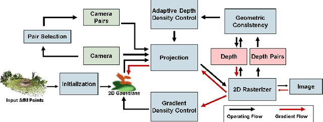
In the rapidly evolving field of 3D reconstruction, 3D Gaussian Splatting (3DGS) and 2D Gaussian Splatting (2DGS) represent significant advancements. Although 2DGS compresses 3D Gaussian primitives into 2D Gaussian surfels to effectively enhance mesh extraction quality, this compression can potentially lead to a decrease in rendering quality. Additionally, unreliable densification processes and the calculation of depth through the accumulation of opacity can compromise the detail of mesh extraction. To address this issue, we introduce MVG-Splatting, a solution guided by Multi-View considerations. Specifically, we integrate an optimized method for calculating normals, which, combined with image gradients, helps rectify inconsistencies in the original depth computations. Additionally, utilizing projection strategies akin to those in Multi-View Stereo (MVS), we propose an adaptive quantile-based method that dynamically determines the level of additional densification guided by depth maps, from coarse to fine detail. Experimental evidence demonstrates that our method not only resolves the issues of rendering quality degradation caused by depth discrepancies but also facilitates direct mesh extraction from dense Gaussian point clouds using the Marching Cubes algorithm. This approach significantly enhances the overall fidelity and accuracy of the 3D reconstruction process, ensuring that both the geometric details and visual quality.
WaterVG: Waterway Visual Grounding based on Text-Guided Vision and mmWave Radar
Apr 01, 2024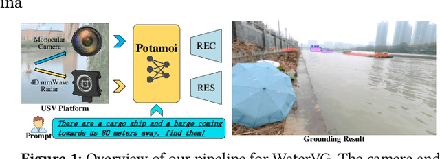
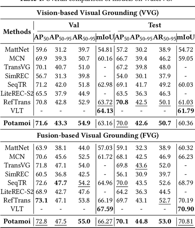
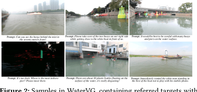
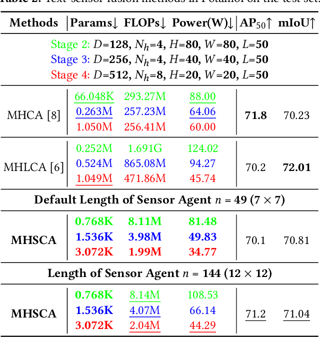
The perception of waterways based on human intent is significant for autonomous navigation and operations of Unmanned Surface Vehicles (USVs) in water environments. Inspired by visual grounding, we introduce WaterVG, the first visual grounding dataset designed for USV-based waterway perception based on human prompts. WaterVG encompasses prompts describing multiple targets, with annotations at the instance level including bounding boxes and masks. Notably, WaterVG includes 11,568 samples with 34,987 referred targets, whose prompts integrates both visual and radar characteristics. The pattern of text-guided two sensors equips a finer granularity of text prompts with visual and radar features of referred targets. Moreover, we propose a low-power visual grounding model, Potamoi, which is a multi-task model with a well-designed Phased Heterogeneous Modality Fusion (PHMF) mode, including Adaptive Radar Weighting (ARW) and Multi-Head Slim Cross Attention (MHSCA). Exactly, ARW extracts required radar features to fuse with vision for prompt alignment. MHSCA is an efficient fusion module with a remarkably small parameter count and FLOPs, elegantly fusing scenario context captured by two sensors with linguistic features, which performs expressively on visual grounding tasks. Comprehensive experiments and evaluations have been conducted on WaterVG, where our Potamoi archives state-of-the-art performances compared with counterparts.