 Add to Chrome
 Add to Firefox
 Add to Edge
Tree crop mapping of South America reveals links to deforestation and conservation
Feb 19, 2026Monitoring tree crop expansion is vital for zero-deforestation policies like the European Union's Regulation on Deforestation-free Products (EUDR). However, these efforts are hindered by a lack of highresolution data distinguishing diverse agricultural systems from forests. Here, we present the first 10m-resolution tree crop map for South America, generated using a multi-modal, spatio-temporal deep learning model trained on Sentinel-1 and Sentinel-2 satellite imagery time series. The map identifies approximately 11 million hectares of tree crops, 23% of which is linked to 2000-2020 forest cover loss. Critically, our analysis reveals that existing regulatory maps supporting the EUDR often classify established agriculture, particularly smallholder agroforestry, as "forest". This discrepancy risks false deforestation alerts and unfair penalties for small-scale farmers. Our work mitigates this risk by providing a high-resolution baseline, supporting conservation policies that are effective, inclusive, and equitable.
Get Your Embedding Space in Order: Domain-Adaptive Regression for Forest Monitoring
May 01, 2024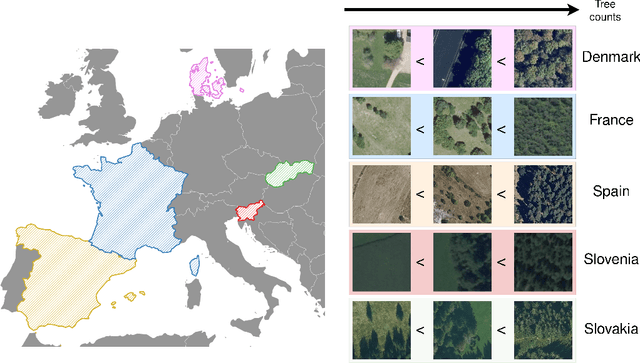
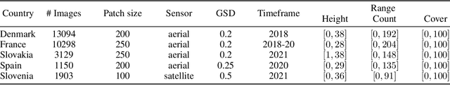
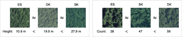
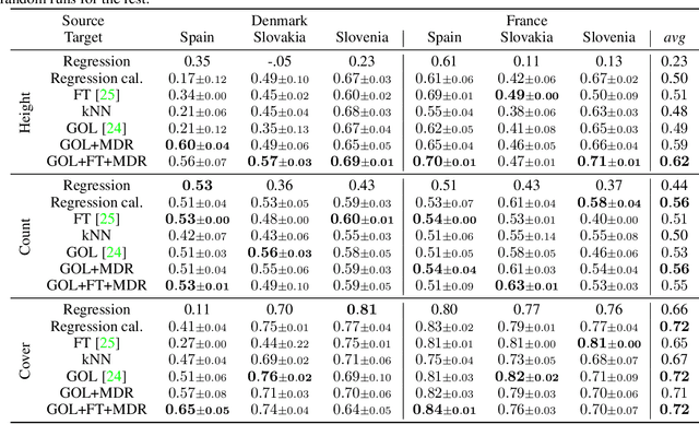
Image-level regression is an important task in Earth observation, where visual domain and label shifts are a core challenge hampering generalization. However, cross-domain regression with remote sensing data remains understudied due to the absence of suited datasets. We introduce a new dataset with aerial and satellite imagery in five countries with three forest-related regression tasks. To match real-world applicative interests, we compare methods through a restrictive setup where no prior on the target domain is available during training, and models are adapted with limited information during testing. Building on the assumption that ordered relationships generalize better, we propose manifold diffusion for regression as a strong baseline for transduction in low-data regimes. Our comparison highlights the comparative advantages of inductive and transductive methods in cross-domain regression.
Mega-cities dominate China's urban greening
Jul 03, 2023


Trees play a crucial role in urban environments, offering various ecosystem services that contribute to public health and human well-being. China has initiated a range of urban greening policies over the past decades, however, monitoring their impact on urban tree dynamics at a national scale has proven challenging. In this study, we deployed nano-satellites to quantify urban tree coverage in all major Chinese cities larger than 50 km2 in 2010 and 2019. Our findings indicate that approximately 6000 km2 (11%) of urban areas were covered by trees in 2019, and 76% of these cities experienced an increase in tree cover compared to 2010. Notably, the increase in tree cover in mega-cities such as Beijing, and Shanghai was approximately twice as large as in most other cities (7.69% vs 3.94%). The study employs a data-driven approach towards assessing urban tree cover changes in relation to greening policies, showing clear signs of tree cover increases but also suggesting an uneven implementation primarily benefiting a few mega-cities.