 Add to Chrome
 Add to Firefox
 Add to Edge
Tree crop mapping of South America reveals links to deforestation and conservation
Feb 19, 2026Monitoring tree crop expansion is vital for zero-deforestation policies like the European Union's Regulation on Deforestation-free Products (EUDR). However, these efforts are hindered by a lack of highresolution data distinguishing diverse agricultural systems from forests. Here, we present the first 10m-resolution tree crop map for South America, generated using a multi-modal, spatio-temporal deep learning model trained on Sentinel-1 and Sentinel-2 satellite imagery time series. The map identifies approximately 11 million hectares of tree crops, 23% of which is linked to 2000-2020 forest cover loss. Critically, our analysis reveals that existing regulatory maps supporting the EUDR often classify established agriculture, particularly smallholder agroforestry, as "forest". This discrepancy risks false deforestation alerts and unfair penalties for small-scale farmers. Our work mitigates this risk by providing a high-resolution baseline, supporting conservation policies that are effective, inclusive, and equitable.
Mining Field Data for Tree Species Recognition at Scale
Aug 28, 2024
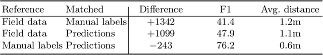
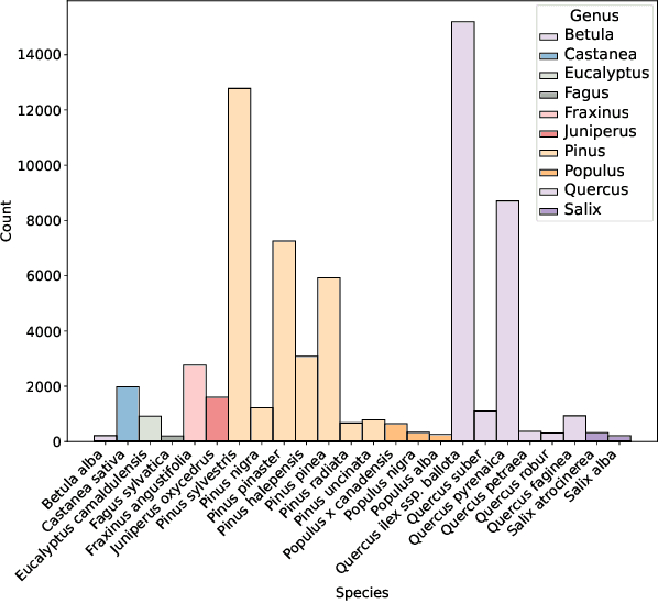

Individual tree species labels are particularly hard to acquire due to the expert knowledge needed and the limitations of photointerpretation. Here, we present a methodology to automatically mine species labels from public forest inventory data, using available pretrained tree detection models. We identify tree instances in aerial imagery and match them with field data with close to zero human involvement. We conduct a series of experiments on the resulting dataset, and show a beneficial effect when adding noisy or even unlabeled data points, highlighting a strong potential for large-scale individual species mapping.