 Add to Chrome
 Add to Firefox
 Add to Edge
Multi-view feature High-order Fusion for Space Weak Object Detection and Segmentation
Jun 13, 2026Weak objects are common in images and videos of space applications. However, it is hard to learn proper representations from their limited appearance information. Inspired by multi-view learning, we develop simple multi-view attentions, treating their outputs as multi-view features. We also propose a multi-view feature high-order fusion method (MHF) to aggregate more accurate and richer features of weak objects. Our MHF extends the commonly used low-order feature fusion method to higher orders. It enhances the model's capacity to capture relevant and complementary information about weak objects. This is achieved by introducing high-order multi-view features perception and a recursive task-contribution gated selection of multi-view features. The new operation is highly flexible and customizable. It is compatible with various variants of multi-view feature representations. We conduct extensive experiments on two newly constructed space science datasets and an open, large-scale satellite video dataset. Our MHF serves as a plug-and-play module and significantly improves various vision transformers and convolution-based detection and segmentation models. We achieve all state-of-the-art accuracies on both tasks across three datasets. Our MHF can be a new basic module for visual modeling that effectively represents weak objects in terms of multi-view learning. The code will be available at https://github.com/Kingdroper/MHF.
Learn Temporal Consistency For Robust Satellite Video Detector
Jun 13, 2026Satellite video object detection (SVOD) for oriented and fine-grained objects plays an important role in satellite applications. Most existing SVOD methods only focus on one or a few coarse-grained categories of moving objects and represent objects with horizontal bounding boxes. They have difficulty extracting complete, accurate, and consistent information about objects in whole satellite videos. In this paper, we propose a satellite video object detection framework based on Temporal Consistency Learning (TCL). TCL adeptly detects oriented and fine-grained objects by leveraging the rich temporal contexts within satellite videos. The framework integrates three key modules: temporal and fine-grained feature aggregation (TFA), structure encoding (SE), and temporal consistency constraint (TCC). TFA and TCC modules facilitate consistent representation learning across frames, while the SE module encodes both appearance and structural information for precise fine-grained recognition. Experimental results on the SAT-MTB benchmark dataset demonstrate TCL's superior performance, achieving a new state-of-the-art oriented and fine-grained detection accuracy of 47.7% mAP--a 4.8% improvement over the baseline. Furthermore, our TCL framework readily accommodates existing image-based detectors, leading to enhanced detection accuracies.
Unifying UAV Cross-View Geo-Localization via 3D Geometric Perception
Apr 02, 2026Cross-view geo-localization for Unmanned Aerial Vehicles (UAVs) operating in GNSS-denied environments remains challenging due to the severe geometric discrepancy between oblique UAV imagery and orthogonal satellite maps. Most existing methods address this problem through a decoupled pipeline of place retrieval and pose estimation, implicitly treating perspective distortion as appearance noise rather than an explicit geometric transformation. In this work, we propose a geometry-aware UAV geo-localization framework that explicitly models the 3D scene geometry to unify coarse place recognition and fine-grained pose estimation within a single inference pipeline. Our approach reconstructs a local 3D scene from multi-view UAV image sequences using a Visual Geometry Grounded Transformer (VGGT), and renders a virtual Bird's-Eye View (BEV) representation that orthorectifies the UAV perspective to align with satellite imagery. This BEV serves as a geometric intermediary that enables robust cross-view retrieval and provides spatial priors for accurate 3 Degrees of Freedom (3-DoF) pose regression. To efficiently handle multiple location hypotheses, we introduce a Satellite-wise Attention Block that isolates the interaction between each satellite candidate and the reconstructed UAV scene, preventing inter-candidate interference while maintaining linear computational complexity. In addition, we release a recalibrated version of the University-1652 dataset with precise coordinate annotations and spatial overlap analysis, enabling rigorous evaluation of end-to-end localization accuracy. Extensive experiments on the refined University-1652 benchmark and SUES-200 demonstrate that our method significantly outperforms state-of-the-art baselines, achieving robust meter-level localization accuracy and improved generalization in complex urban environments.
Bridging the Geometry Mismatch: Frequency-Aware Anisotropic Serialization for Thin-Structure SSMs
Mar 30, 2026The segmentation of thin linear structures is inherently topology allowbreak-critical, where minor local errors can sever long-range connectivity. While recent State-Space Models (SSMs) offer efficient long-range modeling, their isotropic serialization (e.g., raster scanning) creates a geometry mismatch for anisotropic targets, causing state propagation across rather than along the structure trajectories. To address this, we propose FGOS-Net, a framework based on frequency allowbreak-geometric disentanglement. We first decompose features into a stable topology carrier and directional high-frequency bands, leveraging the latter to explicitly correct spatial misalignments induced by downsampling. Building on this calibrated topology, we introduce frequency-aligned scanning that elevates serialization to a geometry-conditioned decision, preserving direction-consistent traces. Coupled with an active probing strategy to selectively inject high-frequency details and suppress texture ambiguity, FGOS-Net consistently outperforms strong baselines across four challenging benchmarks. Notably, it achieves 91.3% mIoU and 97.1% clDice on DeepCrack while running at 80 FPS with only 7.87 GFLOPs.
SDF-Net: Structure-Aware Disentangled Feature Learning for Opticall-SAR Ship Re-identification
Mar 13, 2026Cross-modal ship re-identification (ReID) between optical and synthetic aperture radar (SAR) imagery is fundamentally challenged by the severe radiometric discrepancy between passive optical imaging and coherent active radar sensing. While existing approaches primarily rely on statistical distribution alignment or semantic matching, they often overlook a critical physical prior: ships are rigid objects whose geometric structures remain stable across sensing modalities, whereas texture appearance is highly modality-dependent. In this work, we propose SDF-Net, a Structure-Aware Disentangled Feature Learning Network that systematically incorporates geometric consistency into optical--SAR ship ReID. Built upon a ViT backbone, SDF-Net introduces a structure consistency constraint that extracts scale-invariant gradient energy statistics from intermediate layers to robustly anchor representations against radiometric variations. At the terminal stage, SDF-Net disentangles the learned representations into modality-invariant identity features and modality-specific characteristics. These decoupled cues are then integrated through a parameter-free additive residual fusion, effectively enhancing discriminative power. Extensive experiments on the HOSS-ReID dataset demonstrate that SDF-Net consistently outperforms existing state-of-the-art methods. The code and trained models are publicly available at https://github.com/cfrfree/SDF-Net.
Fluxamba: Topology-Aware Anisotropic State Space Models for Geological Lineament Segmentation in Multi-Source Remote Sensing
Jan 24, 2026The precise segmentation of geological linear features, spanning from planetary lineaments to terrestrial fractures, demands capturing long-range dependencies across complex anisotropic topologies. Although State Space Models (SSMs) offer near-linear computational complexity, their dependence on rigid, axis-aligned scanning trajectories induces a fundamental topological mismatch with curvilinear targets, resulting in fragmented context and feature erosion. To bridge this gap, we propose Fluxamba, a lightweight architecture that introduces a topology-aware feature rectification framework. Central to our design is the Structural Flux Block (SFB), which orchestrates an anisotropic information flux by integrating an Anisotropic Structural Gate (ASG) with a Prior-Modulated Flow (PMF). This mechanism decouples feature orientation from spatial location, dynamically gating context aggregation along the target's intrinsic geometry rather than rigid paths. Furthermore, to mitigate serialization-induced noise in low-contrast environments, we incorporate a Hierarchical Spatial Regulator (HSR) for multi-scale semantic alignment and a High-Fidelity Focus Unit (HFFU) to explicitly maximize the signal-to-noise ratio of faint features. Extensive experiments on diverse geological benchmarks (LROC-Lineament, LineaMapper, and GeoCrack) demonstrate that Fluxamba establishes a new state-of-the-art. Notably, on the challenging LROC-Lineament dataset, it achieves an F1-score of 89.22% and mIoU of 89.87%. Achieving a real-time inference speed of over 24 FPS with only 3.4M parameters and 6.3G FLOPs, Fluxamba reduces computational costs by up to two orders of magnitude compared to heavy-weight baselines, thereby establishing a new Pareto frontier between segmentation fidelity and onboard deployment feasibility.
ABFL: Angular Boundary Discontinuity Free Loss for Arbitrary Oriented Object Detection in Aerial Images
Nov 21, 2023


Arbitrary oriented object detection (AOOD) in aerial images is a widely concerned and highly challenging task, and plays an important role in many scenarios. The core of AOOD involves the representation, encoding, and feature augmentation of oriented bounding-boxes (Bboxes). Existing methods lack intuitive modeling of angle difference measurement in oriented Bbox representations. Oriented Bboxes under different representations exhibit rotational symmetry with varying periods due to angle periodicity. The angular boundary discontinuity (ABD) problem at periodic boundary positions is caused by rotational symmetry in measuring angular differences. In addition, existing methods also use additional encoding-decoding structures for oriented Bboxes. In this paper, we design an angular boundary free loss (ABFL) based on the von Mises distribution. The ABFL aims to solve the ABD problem when detecting oriented objects. Specifically, ABFL proposes to treat angles as circular data rather than linear data when measuring angle differences, aiming to introduce angle periodicity to alleviate the ABD problem and improve the accuracy of angle difference measurement. In addition, ABFL provides a simple and effective solution for various periodic boundary discontinuities caused by rotational symmetry in AOOD tasks, as it does not require additional encoding-decoding structures for oriented Bboxes. Extensive experiments on the DOTA and HRSC2016 datasets show that the proposed ABFL loss outperforms some state-of-the-art methods focused on addressing the ABD problem.
LUAI Challenge 2021 on Learning to Understand Aerial Images
Aug 30, 2021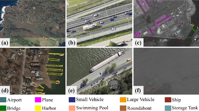
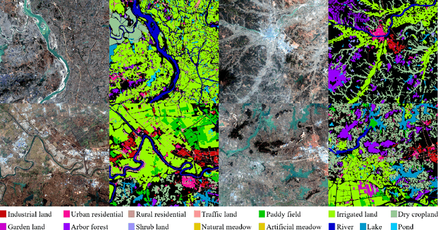
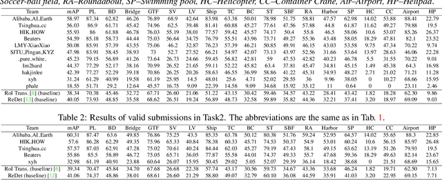
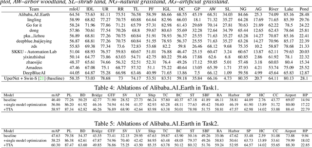
This report summarizes the results of Learning to Understand Aerial Images (LUAI) 2021 challenge held on ICCV 2021, which focuses on object detection and semantic segmentation in aerial images. Using DOTA-v2.0 and GID-15 datasets, this challenge proposes three tasks for oriented object detection, horizontal object detection, and semantic segmentation of common categories in aerial images. This challenge received a total of 146 registrations on the three tasks. Through the challenge, we hope to draw attention from a wide range of communities and call for more efforts on the problems of learning to understand aerial images.
Planetary UAV localization based on Multi-modal Registration with Pre-existing Digital Terrain Model
Jun 24, 2021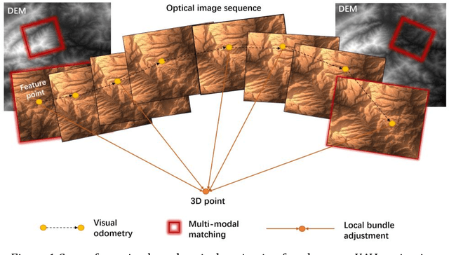
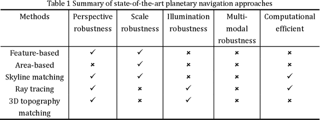
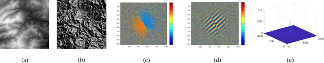
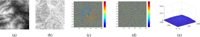
The autonomous real-time optical navigation of planetary UAV is of the key technologies to ensure the success of the exploration. In such a GPS denied environment, vision-based localization is an optimal approach. In this paper, we proposed a multi-modal registration based SLAM algorithm, which estimates the location of a planet UAV using a nadir view camera on the UAV compared with pre-existing digital terrain model. To overcome the scale and appearance difference between on-board UAV images and pre-installed digital terrain model, a theoretical model is proposed to prove that topographic features of UAV image and DEM can be correlated in frequency domain via cross power spectrum. To provide the six-DOF of the UAV, we also developed an optimization approach which fuses the geo-referencing result into a SLAM system via LBA (Local Bundle Adjustment) to achieve robust and accurate vision-based navigation even in featureless planetary areas. To test the robustness and effectiveness of the proposed localization algorithm, a new cross-source drone-based localization dataset for planetary exploration is proposed. The proposed dataset includes 40200 synthetic drone images taken from nine planetary scenes with related DEM query images. Comparison experiments carried out demonstrate that over the flight distance of 33.8km, the proposed method achieved average localization error of 0.45 meters, compared to 1.31 meters by ORB-SLAM, with the processing speed of 12hz which will ensure a real-time performance. We will make our datasets available to encourage further work on this promising topic.
DiRS: On Creating Benchmark Datasets for Remote Sensing Image Interpretation
Jun 22, 2020


The past decade has witnessed great progress on remote sensing (RS) image interpretation and its wide applications. With RS images becoming more accessible than ever before, there is an increasing demand for the automatic interpretation of these images, where benchmark datasets are essential prerequisites for developing and testing intelligent interpretation algorithms. After reviewing existing benchmark datasets in the research community of RS image interpretation, this article discusses the problem of how to efficiently prepare a suitable benchmark dataset for RS image analysis. Specifically, we first analyze the current challenges of developing intelligent algorithms for RS image interpretation with bibliometric investigations. We then present some principles, i.e., diversity, richness, and scalability (called DiRS), on constructing benchmark datasets in efficient manners. Following the DiRS principles, we also provide an example on building datasets for RS image classification, i.e., Million-AID, a new large-scale benchmark dataset containing million instances for RS scene classification. Several challenges and perspectives in RS image annotation are finally discussed to facilitate the research in benchmark dataset construction. We do hope this paper will provide RS community an overall perspective on constructing large-scale and practical image datasets for further research, especially data-driven ones.