 Add to Chrome
 Add to Firefox
 Add to Edge
FLUXtrapolation: A benchmark on extrapolating ecosystem fluxes
May 19, 2026We introduce FLUXtrapolation, a benchmark for extrapolating ecosystem fluxes under progressively harder distribution shifts. Ecosystem fluxes are central to understanding the carbon, water, and energy cycles, yet they can only be measured directly at sparsely located measurement towers. Producing global flux estimates therefore requires training models on observed sites using globally available covariates and predicting in unobserved regions, that is, upscaling. Flux upscaling is a challenging domain generalization problem that is affected by a shift in covariate distribution across climates, ecosystem types, and environmental conditions, as well as by conditional shift: important drivers remain unobserved at global scale. We provide a quantitative analysis of both these shifts in $P_X$ and $P_{Y\mid X}$. FLUXtrapolation is designed based on domain expertise on flux upscaling: it defines temporal, spatial, and temperature-based extrapolation scenarios and evaluates performance across held-out domains, temporal aggregations, and tail errors. In a pilot study, we find that baselines perform similarly under median hourly RMSE, but separate under the proposed tail-focused and multi-scale evaluation. FLUXtrapolation therefore poses a realistic and thus relevant challenge for machine learning methods under distribution shift; at the same time, progress on this benchmark would directly support the scientific goal of improving flux upscaling.
Worst-case low-rank approximations
Mar 11, 2026Real-world data in health, economics, and environmental sciences are often collected across heterogeneous domains (such as hospitals, regions, or time periods). In such settings, distributional shifts can make standard PCA unreliable, in that, for example, the leading principal components may explain substantially less variance in unseen domains than in the training domains. Existing approaches (such as FairPCA) have proposed to consider worst-case (rather than average) performance across multiple domains. This work develops a unified framework, called wcPCA, applies it to other objectives (resulting in the novel estimators such as norm-minPCA and norm-maxregret, which are better suited for applications with heterogeneous total variance) and analyzes their relationship. We prove that for all objectives, the estimators are worst-case optimal not only over the observed source domains but also over all target domains whose covariance lies in the convex hull of the (possibly normalized) source covariances. We establish consistency and asymptotic worst-case guarantees of empirical estimators. We extend our methodology to matrix completion, another problem that makes use of low-rank approximations, and prove approximate worst-case optimality for inductive matrix completion. Simulations and two real-world applications on ecosystem-atmosphere fluxes demonstrate marked improvements in worst-case performance, with only minor losses in average performance.
Maximum Risk Minimization with Random Forests
Dec 11, 2025We consider a regression setting where observations are collected in different environments modeled by different data distributions. The field of out-of-distribution (OOD) generalization aims to design methods that generalize better to test environments whose distributions differ from those observed during training. One line of such works has proposed to minimize the maximum risk across environments, a principle that we refer to as MaxRM (Maximum Risk Minimization). In this work, we introduce variants of random forests based on the principle of MaxRM. We provide computationally efficient algorithms and prove statistical consistency for our primary method. Our proposed method can be used with each of the following three risks: the mean squared error, the negative reward (which relates to the explained variance), and the regret (which quantifies the excess risk relative to the best predictor). For MaxRM with regret as the risk, we prove a novel out-of-sample guarantee over unseen test distributions. Finally, we evaluate the proposed methods on both simulated and real-world data.
Atmospheric Transport Modeling of CO$_2$ with Neural Networks
Aug 20, 2024Accurately describing the distribution of CO$_2$ in the atmosphere with atmospheric tracer transport models is essential for greenhouse gas monitoring and verification support systems to aid implementation of international climate agreements. Large deep neural networks are poised to revolutionize weather prediction, which requires 3D modeling of the atmosphere. While similar in this regard, atmospheric transport modeling is subject to new challenges. Both, stable predictions for longer time horizons and mass conservation throughout need to be achieved, while IO plays a larger role compared to computational costs. In this study we explore four different deep neural networks (UNet, GraphCast, Spherical Fourier Neural Operator and SwinTransformer) which have proven as state-of-the-art in weather prediction to assess their usefulness for atmospheric tracer transport modeling. For this, we assemble the CarbonBench dataset, a systematic benchmark tailored for machine learning emulators of Eulerian atmospheric transport. Through architectural adjustments, we decouple the performance of our emulators from the distribution shift caused by a steady rise in atmospheric CO$_2$. More specifically, we center CO$_2$ input fields to zero mean and then use an explicit flux scheme and a mass fixer to assure mass balance. This design enables stable and mass conserving transport for over 6 months with all four neural network architectures. In our study, the SwinTransformer displays particularly strong emulation skill (90-day $R^2 > 0.99$), with physically plausible emulation even for forward runs of multiple years. This work paves the way forward towards high resolution forward and inverse modeling of inert trace gases with neural networks.
AI for Extreme Event Modeling and Understanding: Methodologies and Challenges
Jun 28, 2024


In recent years, artificial intelligence (AI) has deeply impacted various fields, including Earth system sciences. Here, AI improved weather forecasting, model emulation, parameter estimation, and the prediction of extreme events. However, the latter comes with specific challenges, such as developing accurate predictors from noisy, heterogeneous and limited annotated data. This paper reviews how AI is being used to analyze extreme events (like floods, droughts, wildfires and heatwaves), highlighting the importance of creating accurate, transparent, and reliable AI models. We discuss the hurdles of dealing with limited data, integrating information in real-time, deploying models, and making them understandable, all crucial for gaining the trust of stakeholders and meeting regulatory needs. We provide an overview of how AI can help identify and explain extreme events more effectively, improving disaster response and communication. We emphasize the need for collaboration across different fields to create AI solutions that are practical, understandable, and trustworthy for analyzing and predicting extreme events. Such collaborative efforts aim to enhance disaster readiness and disaster risk reduction.
Bridging Remote Sensors with Multisensor Geospatial Foundation Models
Apr 01, 2024In the realm of geospatial analysis, the diversity of remote sensors, encompassing both optical and microwave technologies, offers a wealth of distinct observational capabilities. Recognizing this, we present msGFM, a multisensor geospatial foundation model that effectively unifies data from four key sensor modalities. This integration spans an expansive dataset of two million multisensor images. msGFM is uniquely adept at handling both paired and unpaired sensor data. For data originating from identical geolocations, our model employs an innovative cross-sensor pretraining approach in masked image modeling, enabling the synthesis of joint representations from diverse sensors. msGFM, incorporating four remote sensors, upholds strong performance, forming a comprehensive model adaptable to various sensor types. msGFM has demonstrated enhanced proficiency in a range of both single-sensor and multisensor downstream tasks. These include scene classification, segmentation, cloud removal, and pan-sharpening. A key discovery of our research is that representations derived from natural images are not always compatible with the distinct characteristics of geospatial remote sensors, underscoring the limitations of existing representations in this field. Our work can serve as a guide for developing multisensor geospatial pretraining models, paving the way for more advanced geospatial capabilities.
Double machine learning for causal hybrid modeling -- applications in the Earth sciences
Feb 20, 2024Hybrid modeling integrates machine learning with scientific knowledge with the goal of enhancing interpretability, generalization, and adherence to natural laws. Nevertheless, equifinality and regularization biases pose challenges in hybrid modeling to achieve these purposes. This paper introduces a novel approach to estimating hybrid models via a causal inference framework, specifically employing Double Machine Learning (DML) to estimate causal effects. We showcase its use for the Earth sciences on two problems related to carbon dioxide fluxes. In the $Q_{10}$ model, we demonstrate that DML-based hybrid modeling is superior in estimating causal parameters over end-to-end deep neural network (DNN) approaches, proving efficiency, robustness to bias from regularization methods, and circumventing equifinality. Our approach, applied to carbon flux partitioning, exhibits flexibility in accommodating heterogeneous causal effects. The study emphasizes the necessity of explicitly defining causal graphs and relationships, advocating for this as a general best practice. We encourage the continued exploration of causality in hybrid models for more interpretable and trustworthy results in knowledge-guided machine learning.
Forecasting localized weather impacts on vegetation as seen from space with meteo-guided video prediction
Mar 28, 2023


We present a novel approach for modeling vegetation response to weather in Europe as measured by the Sentinel 2 satellite. Existing satellite imagery forecasting approaches focus on photorealistic quality of the multispectral images, while derived vegetation dynamics have not yet received as much attention. We leverage both spatial and temporal context by extending state-of-the-art video prediction methods with weather guidance. We extend the EarthNet2021 dataset to be suitable for vegetation modeling by introducing a learned cloud mask and an appropriate evaluation scheme. Qualitative and quantitative experiments demonstrate superior performance of our approach over a wide variety of baseline methods, including leading approaches to satellite imagery forecasting. Additionally, we show how our modeled vegetation dynamics can be leveraged in a downstream task: inferring gross primary productivity for carbon monitoring. To the best of our knowledge, this work presents the first models for continental-scale vegetation modeling at fine resolution able to capture anomalies beyond the seasonal cycle, thereby paving the way for predictive assessments of vegetation status.
Learning to forecast vegetation greenness at fine resolution over Africa with ConvLSTMs
Oct 24, 2022


Forecasting the state of vegetation in response to climate and weather events is a major challenge. Its implementation will prove crucial in predicting crop yield, forest damage, or more generally the impact on ecosystems services relevant for socio-economic functioning, which if absent can lead to humanitarian disasters. Vegetation status depends on weather and environmental conditions that modulate complex ecological processes taking place at several timescales. Interactions between vegetation and different environmental drivers express responses at instantaneous but also time-lagged effects, often showing an emerging spatial context at landscape and regional scales. We formulate the land surface forecasting task as a strongly guided video prediction task where the objective is to forecast the vegetation developing at very fine resolution using topography and weather variables to guide the prediction. We use a Convolutional LSTM (ConvLSTM) architecture to address this task and predict changes in the vegetation state in Africa using Sentinel-2 satellite NDVI, having ERA5 weather reanalysis, SMAP satellite measurements, and topography (DEM of SRTMv4.1) as variables to guide the prediction. Ours results highlight how ConvLSTM models can not only forecast the seasonal evolution of NDVI at high resolution, but also the differential impacts of weather anomalies over the baselines. The model is able to predict different vegetation types, even those with very high NDVI variability during target length, which is promising to support anticipatory actions in the context of drought-related disasters.
On the Generalization of Agricultural Drought Classification from Climate Data
Nov 30, 2021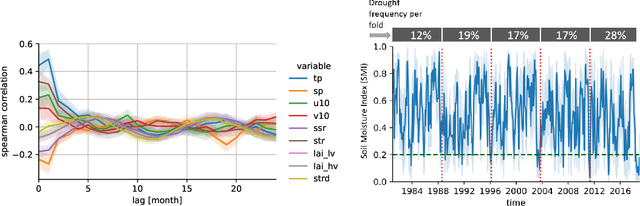
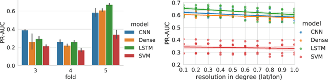
Climate change is expected to increase the likelihood of drought events, with severe implications for food security. Unlike other natural disasters, droughts have a slow onset and depend on various external factors, making drought detection in climate data difficult. In contrast to existing works that rely on simple relative drought indices as ground-truth data, we build upon soil moisture index (SMI) obtained from a hydrological model. This index is directly related to insufficiently available water to vegetation. Given ERA5-Land climate input data of six months with land use information from MODIS satellite observation, we compare different models with and without sequential inductive bias in classifying droughts based on SMI. We use PR-AUC as the evaluation measure to account for the class imbalance and obtain promising results despite a challenging time-based split. We further show in an ablation study that the models retain their predictive capabilities given input data of coarser resolutions, as frequently encountered in climate models.