 Add to Chrome
 Add to Firefox
 Add to Edge
On-Orbit Real-Time Wildfire Detection Under On-Board Constraints
May 07, 2026We present a deployed system for on-orbit wildfire detection aboard a nine-satellite commercial thermal infrared constellation, operating under demanding joint constraints: sub-megabyte model footprint, sub-150 ms per-batch TensorRT FP16 inference on an NVIDIA Jetson Xavier NX, and an end-to-end alert pipeline targeting under 10 minutes from satellite overpass to fire event communication. The system operates on uncalibrated mid-wave infrared (MWIR) single-band imagery at 200 m ground sampling distance, where fires frequently appear as sub-pixel or single-pixel thermal anomalies under extreme class imbalance -- challenges not addressed by the contextual thermal-thresholding pipelines (MODIS, VIIRS) that currently dominate operational fire monitoring. We present an empirical study of lightweight dense representation learning for this regime using a proprietary nine-satellite MWIR dataset. We compare dense masked autoencoding (DenseMAE) and a hybrid DenseMAE+EMA (exponential moving average) distillation variant, and evaluate representations via linear probing and full-distribution pixel-level average precision (AP) under extreme class imbalance. DenseMAE pretraining enables compact downstream models on the latency-accuracy Pareto frontier: our fastest SSL-pretrained model achieves 0.640 test AP and 0.69 event-level Fire-F1 with 65.34 ms latency per batch and a 0.52 MB engine, without pruning or compression. The best configuration reaches 0.699 AP and 0.744 Fire-F1 below 1 MB, outperforming a supervised baseline (0.650 AP) under comparable constraints.
On the Generalization of Agricultural Drought Classification from Climate Data
Nov 30, 2021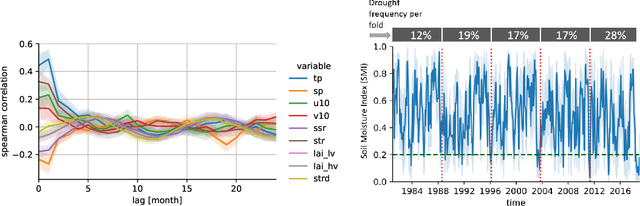
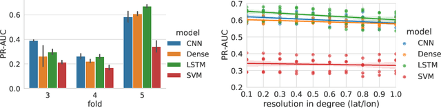
Climate change is expected to increase the likelihood of drought events, with severe implications for food security. Unlike other natural disasters, droughts have a slow onset and depend on various external factors, making drought detection in climate data difficult. In contrast to existing works that rely on simple relative drought indices as ground-truth data, we build upon soil moisture index (SMI) obtained from a hydrological model. This index is directly related to insufficiently available water to vegetation. Given ERA5-Land climate input data of six months with land use information from MODIS satellite observation, we compare different models with and without sequential inductive bias in classifying droughts based on SMI. We use PR-AUC as the evaluation measure to account for the class imbalance and obtain promising results despite a challenging time-based split. We further show in an ablation study that the models retain their predictive capabilities given input data of coarser resolutions, as frequently encountered in climate models.