 Add to Chrome
 Add to Firefox
 Add to Edge
Atmospheric Transport Modeling of CO$_2$ with Neural Networks
Aug 20, 2024Accurately describing the distribution of CO$_2$ in the atmosphere with atmospheric tracer transport models is essential for greenhouse gas monitoring and verification support systems to aid implementation of international climate agreements. Large deep neural networks are poised to revolutionize weather prediction, which requires 3D modeling of the atmosphere. While similar in this regard, atmospheric transport modeling is subject to new challenges. Both, stable predictions for longer time horizons and mass conservation throughout need to be achieved, while IO plays a larger role compared to computational costs. In this study we explore four different deep neural networks (UNet, GraphCast, Spherical Fourier Neural Operator and SwinTransformer) which have proven as state-of-the-art in weather prediction to assess their usefulness for atmospheric tracer transport modeling. For this, we assemble the CarbonBench dataset, a systematic benchmark tailored for machine learning emulators of Eulerian atmospheric transport. Through architectural adjustments, we decouple the performance of our emulators from the distribution shift caused by a steady rise in atmospheric CO$_2$. More specifically, we center CO$_2$ input fields to zero mean and then use an explicit flux scheme and a mass fixer to assure mass balance. This design enables stable and mass conserving transport for over 6 months with all four neural network architectures. In our study, the SwinTransformer displays particularly strong emulation skill (90-day $R^2 > 0.99$), with physically plausible emulation even for forward runs of multiple years. This work paves the way forward towards high resolution forward and inverse modeling of inert trace gases with neural networks.
DeepExtremeCubes: Integrating Earth system spatio-temporal data for impact assessment of climate extremes
Jun 26, 2024


With climate extremes' rising frequency and intensity, robust analytical tools are crucial to predict their impacts on terrestrial ecosystems. Machine learning techniques show promise but require well-structured, high-quality, and curated analysis-ready datasets. Earth observation datasets comprehensively monitor ecosystem dynamics and responses to climatic extremes, yet the data complexity can challenge the effectiveness of machine learning models. Despite recent progress in deep learning to ecosystem monitoring, there is a need for datasets specifically designed to analyse compound heatwave and drought extreme impact. Here, we introduce the DeepExtremeCubes database, tailored to map around these extremes, focusing on persistent natural vegetation. It comprises over 40,000 spatially sampled small data cubes (i.e. minicubes) globally, with a spatial coverage of 2.5 by 2.5 km. Each minicube includes (i) Sentinel-2 L2A images, (ii) ERA5-Land variables and generated extreme event cube covering 2016 to 2022, and (iii) ancillary land cover and topography maps. The paper aims to (1) streamline data accessibility, structuring, pre-processing, and enhance scientific reproducibility, and (2) facilitate biosphere dynamics forecasting in response to compound extremes.
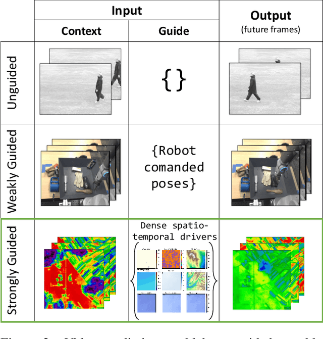
Forecasting localized weather impacts on vegetation as seen from space with meteo-guided video prediction
Mar 28, 2023


We present a novel approach for modeling vegetation response to weather in Europe as measured by the Sentinel 2 satellite. Existing satellite imagery forecasting approaches focus on photorealistic quality of the multispectral images, while derived vegetation dynamics have not yet received as much attention. We leverage both spatial and temporal context by extending state-of-the-art video prediction methods with weather guidance. We extend the EarthNet2021 dataset to be suitable for vegetation modeling by introducing a learned cloud mask and an appropriate evaluation scheme. Qualitative and quantitative experiments demonstrate superior performance of our approach over a wide variety of baseline methods, including leading approaches to satellite imagery forecasting. Additionally, we show how our modeled vegetation dynamics can be leveraged in a downstream task: inferring gross primary productivity for carbon monitoring. To the best of our knowledge, this work presents the first models for continental-scale vegetation modeling at fine resolution able to capture anomalies beyond the seasonal cycle, thereby paving the way for predictive assessments of vegetation status.
Learning to forecast vegetation greenness at fine resolution over Africa with ConvLSTMs
Oct 24, 2022


Forecasting the state of vegetation in response to climate and weather events is a major challenge. Its implementation will prove crucial in predicting crop yield, forest damage, or more generally the impact on ecosystems services relevant for socio-economic functioning, which if absent can lead to humanitarian disasters. Vegetation status depends on weather and environmental conditions that modulate complex ecological processes taking place at several timescales. Interactions between vegetation and different environmental drivers express responses at instantaneous but also time-lagged effects, often showing an emerging spatial context at landscape and regional scales. We formulate the land surface forecasting task as a strongly guided video prediction task where the objective is to forecast the vegetation developing at very fine resolution using topography and weather variables to guide the prediction. We use a Convolutional LSTM (ConvLSTM) architecture to address this task and predict changes in the vegetation state in Africa using Sentinel-2 satellite NDVI, having ERA5 weather reanalysis, SMAP satellite measurements, and topography (DEM of SRTMv4.1) as variables to guide the prediction. Ours results highlight how ConvLSTM models can not only forecast the seasonal evolution of NDVI at high resolution, but also the differential impacts of weather anomalies over the baselines. The model is able to predict different vegetation types, even those with very high NDVI variability during target length, which is promising to support anticipatory actions in the context of drought-related disasters.
EarthNet2021: A large-scale dataset and challenge for Earth surface forecasting as a guided video prediction task
Apr 16, 2021
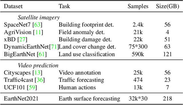
Satellite images are snapshots of the Earth surface. We propose to forecast them. We frame Earth surface forecasting as the task of predicting satellite imagery conditioned on future weather. EarthNet2021 is a large dataset suitable for training deep neural networks on the task. It contains Sentinel 2 satellite imagery at 20m resolution, matching topography and mesoscale (1.28km) meteorological variables packaged into 32000 samples. Additionally we frame EarthNet2021 as a challenge allowing for model intercomparison. Resulting forecasts will greatly improve (>x50) over the spatial resolution found in numerical models. This allows localized impacts from extreme weather to be predicted, thus supporting downstream applications such as crop yield prediction, forest health assessments or biodiversity monitoring. Find data, code, and how to participate at www.earthnet.tech
EarthNet2021: A novel large-scale dataset and challenge for forecasting localized climate impacts
Dec 11, 2020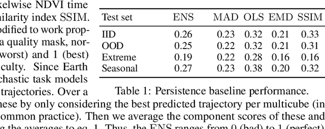
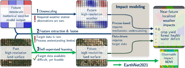
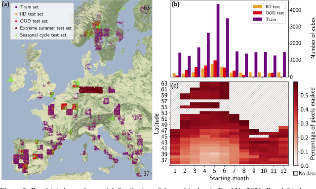
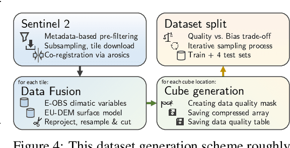
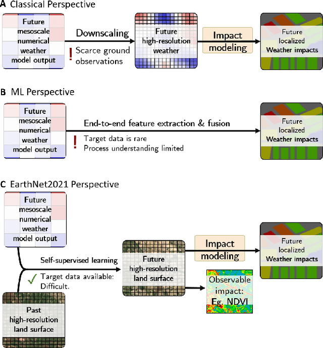
Climate change is global, yet its concrete impacts can strongly vary between different locations in the same region. Seasonal weather forecasts currently operate at the mesoscale (> 1 km). For more targeted mitigation and adaptation, modelling impacts to < 100 m is needed. Yet, the relationship between driving variables and Earth's surface at such local scales remains unresolved by current physical models. Large Earth observation datasets now enable us to create machine learning models capable of translating coarse weather information into high-resolution Earth surface forecasts. Here, we define high-resolution Earth surface forecasting as video prediction of satellite imagery conditional on mesoscale weather forecasts. Video prediction has been tackled with deep learning models. Developing such models requires analysis-ready datasets. We introduce EarthNet2021, a new, curated dataset containing target spatio-temporal Sentinel 2 satellite imagery at 20 m resolution, matched with high-resolution topography and mesoscale (1.28 km) weather variables. With over 32000 samples it is suitable for training deep neural networks. Comparing multiple Earth surface forecasts is not trivial. Hence, we define the EarthNetScore, a novel ranking criterion for models forecasting Earth surface reflectance. For model intercomparison we frame EarthNet2021 as a challenge with four tracks based on different test sets. These allow evaluation of model validity and robustness as well as model applicability to extreme events and the complete annual vegetation cycle. In addition to forecasting directly observable weather impacts through satellite-derived vegetation indices, capable Earth surface models will enable downstream applications such as crop yield prediction, forest health assessments, coastline management, or biodiversity monitoring. Find data, code, and how to participate at www.earthnet.tech .
Assessing out-of-domain generalization for robust building damage detection
Nov 20, 2020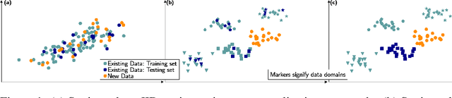
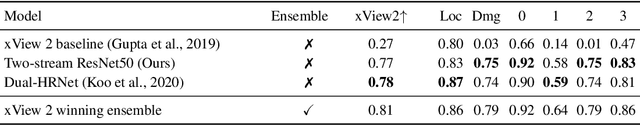
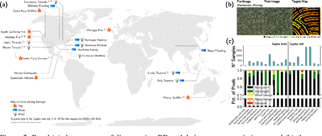
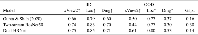
An important step for limiting the negative impact of natural disasters is rapid damage assessment after a disaster occurred. For instance, building damage detection can be automated by applying computer vision techniques to satellite imagery. Such models operate in a multi-domain setting: every disaster is inherently different (new geolocation, unique circumstances), and models must be robust to a shift in distribution between disaster imagery available for training and the images of the new event. Accordingly, estimating real-world performance requires an out-of-domain (OOD) test set. However, building damage detection models have so far been evaluated mostly in the simpler yet unrealistic in-distribution (IID) test setting. Here we argue that future work should focus on the OOD regime instead. We assess OOD performance of two competitive damage detection models and find that existing state-of-the-art models show a substantial generalization gap: their performance drops when evaluated OOD on new disasters not used during training. Moreover, IID performance is not predictive of OOD performance, rendering current benchmarks uninformative about real-world performance. Code and model weights are available at https://github.com/ecker-lab/robust-bdd.