 Add to Chrome
 Add to Firefox
 Add to Edge
CDSeg: A Renderable Gaussian Carrier for Image-to-3D Label Transfer
Aug 06, 2026
Modern image models provide strong cues about \emph{what} should be segmented in each view, but their masks do not by themselves determine \emph{where} those labels should persist in 3D. We present Cross-Domain Segmentation via Gaussian Splatting (CDSeg), a label-transfer interface that requires no task-specific 3D segmentation training and uses Gaussian primitives as a renderable label carrier. An external mask source supplies the labels, while renderer-derived visibility determines which 3D primitives receive them. The carrier is instantiated either by completing each input point into one Gaussian, preserving its index, or by reusing the native primitives of an optimized Gaussian scene. CDSeg records pixel--primitive associations during rendering and fuses multi-view masks through voting and a local filter. The resulting labels can be returned to the original points, retained on the native Gaussian scene, or rendered into other views. CDSeg covers promptable, automatic instance, semantic, and LiDAR settings and processes scenes with millions of primitives in seconds. It obtains 92.35\% mIoU on DesktopObjects-360, 95.89\% on NeRDS-360, and 65.77\% on the full ScanNet-v2 validation split using the provided 2D semantic annotations. CDSeg thereby provides one interface for reusing 2D masks across point clouds, Gaussian scenes, and image views without a task-specific 3D segmentation network.

Evaluating Machine Learning Models for Post-Wildfire Debris-Flow Prediction
Aug 05, 2026Prediction of post-wildfire debris flows is critical for mitigating hazards to communities, infrastructure, and resources during intense rainfall in recently burned areas. However, identifying reliable machine learning models is complicated by overlapping debris-flow and non-debris-flow events in feature space, the need for model interpretability, and limited training data. This paper addresses these challenges through a systematic evaluation of machine learning models in terms of predictive performance, feature importance, and synthetic data augmentation. Using basin-scale observations of post-wildfire debris-flow events across the western United States, we compare 15 models, including the Tabular Prior-Data Fitted Network (TabPFN). Repeated stratified cross-validation shows that TabPFN achieves the highest unaugmented performance with a threat score of 0.637, closely followed by the best tree-based models. SHapley Additive exPlanations (SHAP) are used to identify the features driving predictions, revealing that short-duration rainfall intensity and storm accumulation consistently rank highest, while burn severity and terrain features contribute less. We further evaluate synthetic data augmentation using TabPFN-generated samples to address the scarcity of debris-flow observations. Synthetic augmentation improves the performance of all models except CNN, with the largest mean threat score increase of +0.041 among the deep learning models. By combining rigorous model benchmarking, interpretable feature analysis, and synthetic data augmentation, this work provides a comprehensive framework for improving post-wildfire debris-flow prediction.
Rapid Forest Fuel Load Estimation via Virtual Remote Sensing and Metric-Scale Feed-Forward 3D Reconstruction
May 11, 2026Accurate quantification of forest coverage and combustible biomass (fuel load) is critical for wildfire risk assessment and ecosystem management. However, traditional methods relying on airborne LiDAR or field surveys are cost-prohibitive and time-intensive, while satellite imagery often lacks the vertical resolution required for canopy volume analysis. This paper proposes a novel, automated pipeline for rapid forest inventory using virtual remote sensing data derived from Google Earth Studio (GES). Our approach first generates low-altitude orbital imagery and camera poses for a target region. For dense 3D reconstruction, we employ Pi-Long, developed within the VGGT-Long framework. This model serves as a scalable extension of the Pi-3 feed-forward Transformer architecture. To address the inherent scale ambiguity in monocular reconstruction, we introduce a metric recovery module that aligns the reconstructed trajectory with GES ground truth poses via Sim(3) Umeyama optimization. The metric-scale point cloud is then orthogonally projected into Bird's-Eye-View (BEV) height and density maps. Finally, we employ a watershed-based segmentation algorithm combined with height variance analysis to classify tree species (conifer vs. broadleaf), calculate Leaf Area Index (LAI), and estimate total fuel load. Experimental results demonstrate that this pipeline offers a scalable, cost-effective alternative to physical scanning, enabling near-real-time estimation of forest biomass with high geometric consistency.
mHC-HSI: Clustering-Guided Hyper-Connection Mamba for Hyperspectral Image Classification
Mar 03, 2026Recently, DeepSeek has invented the manifold-constrained hyper-connection (mHC) approach which has demonstrated significant improvements over the traditional residual connection in deep learning models \cite{xie2026mhc}. Nevertheless, this approach has not been tailor-designed for improving hyperspectral image (HSI) classification. This paper presents a clustering-guided mHC Mamba model (mHC-HSI) for enhanced HSI classification, with the following contributions. First, to improve spatial-spectral feature learning, we design a novel clustering-guided Mamba module, based on the mHC framework, that explicitly learns both spatial and spectral information in HSI. Second, to decompose the complex and heterogeneous HSI into smaller clusters, we design a new implementation of the residual matrix in mHC, which can be treated as soft cluster membership maps, leading to improved explainability of the mHC approach. Third, to leverage the physical spectral knowledge, we divide the spectral bands into physically-meaningful groups and use them as the "parallel streams" in mHC, leading to a physically-meaningful approach with enhanced interpretability. The proposed approach is tested on benchmark datasets in comparison with the state-of-the-art methods, and the results suggest that the proposed model not only improves the accuracy but also enhances the model explainability. Code is available here: https://github.com/GSIL-UCalgary/mHC_HyperSpectral
White-Box mHC: Electromagnetic Spectrum-Aware and Interpretable Stream Interactions for Hyperspectral Image Classification
Jan 22, 2026In hyperspectral image classification (HSIC), most deep learning models rely on opaque spectral-spatial feature mixing, limiting their interpretability and hindering understanding of internal decision mechanisms. We present physical spectrum-aware white-box mHC, named ES-mHC, a hyper-connection framework that explicitly models interactions among different electromagnetic spectrum groupings (residual stream in mHC) interactions using structured, directional matrices. By separating feature representation from interaction structure, ES-mHC promotes electromagnetic spectrum grouping specialization, reduces redundancy, and exposes internal information flow that can be directly visualized and spatially analyzed. Using hyperspectral image classification as a representative testbed, we demonstrate that the learned hyper-connection matrices exhibit coherent spatial patterns and asymmetric interaction behaviors, providing mechanistic insight into the model internal dynamics. Furthermore, we find that increasing the expansion rate accelerates the emergence of structured interaction patterns. These results suggest that ES-mHC transforms HSIC from a purely black-box prediction task into a structurally transparent, partially white-box learning process.
Clustering-Guided Spatial-Spectral Mamba for Hyperspectral Image Classification
Jan 22, 2026Although Mamba models greatly improve Hyperspectral Image (HSI) classification, they have critical challenges in terms defining efficient and adaptive token sequences for improve performance. This paper therefore presents CSSMamba (Clustering-guided Spatial-Spectral Mamba) framework to better address the challenges, with the following contributions. First, to achieve efficient and adaptive token sequences for improved Mamba performance, we integrate the clustering mechanism into a spatial Mamba architecture, leading to a cluster-guided spatial Mamba module (CSpaMamba) that reduces the Mamba sequence length and improves Mamba feature learning capability. Second, to improve the learning of both spatial and spectral information, we integrate the CSpaMamba module with a spectral mamba module (SpeMamba), leading to a complete clustering-guided spatial-spectral Mamba framework. Third, to further improve feature learning capability, we introduce an Attention-Driven Token Selection mechanism to optimize Mamba token sequencing. Last, to seamlessly integrate clustering into the Mamba model in a coherent manner, we design a Learnable Clustering Module that learns the cluster memberships in an adaptive manner. Experiments on the Pavia University, Indian Pines, and Liao-Ning 01 datasets demonstrate that CSSMamba achieves higher accuracy and better boundary preservation compared to state-of-the-art CNN, Transformer, and Mamba-based methods.
Trustworthy Data-Driven Wildfire Risk Prediction and Understanding in Western Canada
Jan 04, 2026In recent decades, the intensification of wildfire activity in western Canada has resulted in substantial socio-economic and environmental losses. Accurate wildfire risk prediction is hindered by the intrinsic stochasticity of ignition and spread and by nonlinear interactions among fuel conditions, meteorology, climate variability, topography, and human activities, challenging the reliability and interpretability of purely data-driven models. We propose a trustworthy data-driven wildfire risk prediction framework based on long-sequence, multi-scale temporal modeling, which integrates heterogeneous drivers while explicitly quantifying predictive uncertainty and enabling process-level interpretation. Evaluated over western Canada during the record-breaking 2023 and 2024 fire seasons, the proposed model outperforms existing time-series approaches, achieving an F1 score of 0.90 and a PR-AUC of 0.98 with low computational cost. Uncertainty-aware analysis reveals structured spatial and seasonal patterns in predictive confidence, highlighting increased uncertainty associated with ambiguous predictions and spatiotemporal decision boundaries. SHAP-based interpretation provides mechanistic understanding of wildfire controls, showing that temperature-related drivers dominate wildfire risk in both years, while moisture-related constraints play a stronger role in shaping spatial and land-cover-specific contrasts in 2024 compared to the widespread hot and dry conditions of 2023. Data and code are available at https://github.com/SynUW/mmFire.
Multitask GLocal OBIA-Mamba for Sentinel-2 Landcover Mapping
Nov 13, 2025Although Sentinel-2 based land use and land cover (LULC) classification is critical for various environmental monitoring applications, it is a very difficult task due to some key data challenges (e.g., spatial heterogeneity, context information, signature ambiguity). This paper presents a novel Multitask Glocal OBIA-Mamba (MSOM) for enhanced Sentinel-2 classification with the following contributions. First, an object-based image analysis (OBIA) Mamba model (OBIA-Mamba) is designed to reduce redundant computation without compromising fine-grained details by using superpixels as Mamba tokens. Second, a global-local (GLocal) dual-branch convolutional neural network (CNN)-mamba architecture is designed to jointly model local spatial detail and global contextual information. Third, a multitask optimization framework is designed to employ dual loss functions to balance local precision with global consistency. The proposed approach is tested on Sentinel-2 imagery in Alberta, Canada, in comparison with several advanced classification approaches, and the results demonstrate that the proposed approach achieves higher classification accuracy and finer details that the other state-of-the-art methods.
SAGOnline: Segment Any Gaussians Online
Aug 11, 20253D Gaussian Splatting (3DGS) has emerged as a powerful paradigm for explicit 3D scene representation, yet achieving efficient and consistent 3D segmentation remains challenging. Current methods suffer from prohibitive computational costs, limited 3D spatial reasoning, and an inability to track multiple objects simultaneously. We present Segment Any Gaussians Online (SAGOnline), a lightweight and zero-shot framework for real-time 3D segmentation in Gaussian scenes that addresses these limitations through two key innovations: (1) a decoupled strategy that integrates video foundation models (e.g., SAM2) for view-consistent 2D mask propagation across synthesized views; and (2) a GPU-accelerated 3D mask generation and Gaussian-level instance labeling algorithm that assigns unique identifiers to 3D primitives, enabling lossless multi-object tracking and segmentation across views. SAGOnline achieves state-of-the-art performance on NVOS (92.7% mIoU) and Spin-NeRF (95.2% mIoU) benchmarks, outperforming Feature3DGS, OmniSeg3D-gs, and SA3D by 15--1500 times in inference speed (27 ms/frame). Qualitative results demonstrate robust multi-object segmentation and tracking in complex scenes. Our contributions include: (i) a lightweight and zero-shot framework for 3D segmentation in Gaussian scenes, (ii) explicit labeling of Gaussian primitives enabling simultaneous segmentation and tracking, and (iii) the effective adaptation of 2D video foundation models to the 3D domain. This work allows real-time rendering and 3D scene understanding, paving the way for practical AR/VR and robotic applications.
Sparse Deformable Mamba for Hyperspectral Image Classification
Apr 15, 2025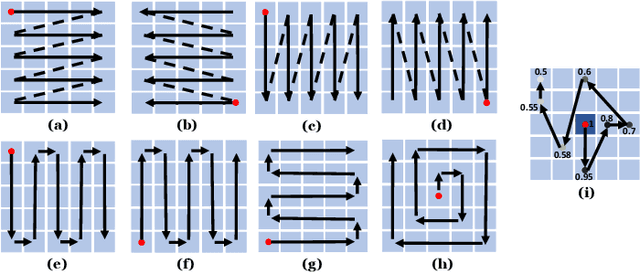
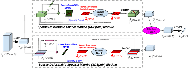
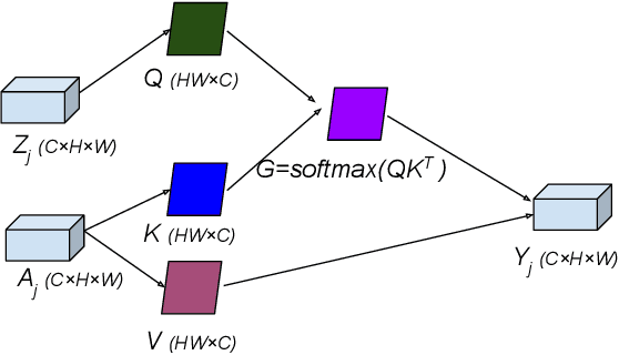
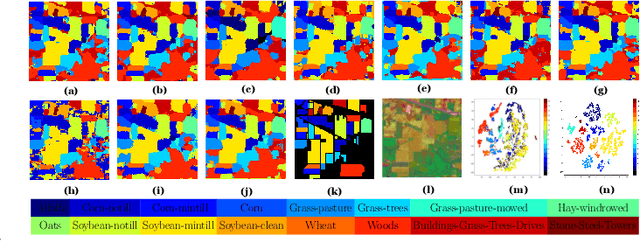
Although Mamba models significantly improve hyperspectral image (HSI) classification, one critical challenge is the difficulty in building the sequence of Mamba tokens efficiently. This paper presents a Sparse Deformable Mamba (SDMamba) approach for enhanced HSI classification, with the following contributions. First, to enhance Mamba sequence, an efficient Sparse Deformable Sequencing (SDS) approach is designed to adaptively learn the ''optimal" sequence, leading to sparse and deformable Mamba sequence with increased detail preservation and decreased computations. Second, to boost spatial-spectral feature learning, based on SDS, a Sparse Deformable Spatial Mamba Module (SDSpaM) and a Sparse Deformable Spectral Mamba Module (SDSpeM) are designed for tailored modeling of the spatial information spectral information. Last, to improve the fusion of SDSpaM and SDSpeM, an attention based feature fusion approach is designed to integrate the outputs of the SDSpaM and SDSpeM. The proposed method is tested on several benchmark datasets with many state-of-the-art approaches, demonstrating that the proposed approach can achieve higher accuracy with less computation, and better detail small-class preservation capability.