 Add to Chrome
 Add to Firefox
 Add to Edge
RepBench: Compiling Benchmarks into Capability Representations for Large Language Models
Jul 30, 2026
Representation engineering reads and steers capability directions in large language models, yet methods are typically evaluated on paper-specific synthetic data. The resulting measurements are difficult to compare or reproduce and may reflect surface patterns rather than capabilities. We present RepBench, a benchmark-grounded data layer for capability-aligned representation probing. Crawling 13,427 benchmark papers yields a taxonomy of 182 capability clusters in 13 families; harvesting 353 public benchmark datasets yields 46,149 audited probe texts covering 94 capabilities, each supported by at least two independent benchmarks. This multi-benchmark design reduces dependence on any single source: raw per-text vectors exhibit no natural cluster granularity, whereas benchmark-pooled capability vectors show an interior clustering optimum at a small number of clusters on all 12 evaluated models, with low agreement to the human taxonomy. Under cross-benchmark transfer evaluation across twelve models completed by all four readouts, difference-in-means attains the highest model-level mean on ten models, while logistic regression wins the most capability-model cells. This disagreement shows that the readout method and aggregation criterion are meaningful evaluation dimensions. The pipeline, corpus, and evaluation code are released as a reusable closed-loop workflow.

Miles: Metric Learning with Expandable Subspace for Pre-Trained Model-Based Class-Incremental Learning
Jul 20, 2026Class Incremental Learning (CIL) aims to learn new concepts consistently from a data stream without forgetting. Unlike typical CIL methods which need to learn a model from scratch, pre-trained model (PTM) can easily adapt to a new task with fine-tuning. However, existing PTM-based CIL methods fail to achieve a trade-off between performance and computational expenditure, i.e., they either adopt the same parameter space so that leading catastrophic forgetting, or expand a new branch for each task but adding more computational cost. To this end, we propose MetrIc Learning with Expandable Subspace (Miles) to harness the prior information within pre-trained knowledge, thereby orchestrating an efficient expansion of the parameter space through guided optimization. Specifically, it decouples the learnable modules with the pre-trained model, exploiting prior information from intermediate features of the backbone network to enable more flexible parameter expansion. Then, a central loss is adopted to guide the new category to cluster towards the corresponding prototype in the new task subspace while incorporating an auxiliary distance regularization term to maintain metric equilibrium across tasks. Extensive experiments on six benchmark datasets demonstrate that Miles achieves state-of-the-art performance in various CIL settings.
AeroGen: Enhancing Remote Sensing Object Detection with Diffusion-Driven Data Generation
Nov 26, 2024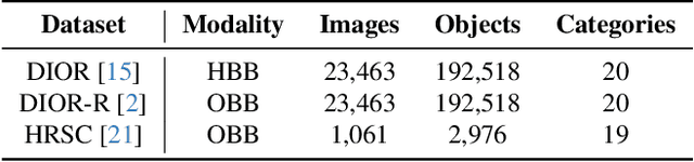
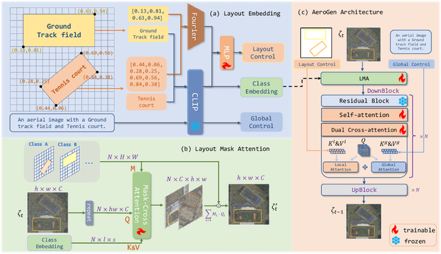


Remote sensing image object detection (RSIOD) aims to identify and locate specific objects within satellite or aerial imagery. However, there is a scarcity of labeled data in current RSIOD datasets, which significantly limits the performance of current detection algorithms. Although existing techniques, e.g., data augmentation and semi-supervised learning, can mitigate this scarcity issue to some extent, they are heavily dependent on high-quality labeled data and perform worse in rare object classes. To address this issue, this paper proposes a layout-controllable diffusion generative model (i.e. AeroGen) tailored for RSIOD. To our knowledge, AeroGen is the first model to simultaneously support horizontal and rotated bounding box condition generation, thus enabling the generation of high-quality synthetic images that meet specific layout and object category requirements. Additionally, we propose an end-to-end data augmentation framework that integrates a diversity-conditioned generator and a filtering mechanism to enhance both the diversity and quality of generated data. Experimental results demonstrate that the synthetic data produced by our method are of high quality and diversity. Furthermore, the synthetic RSIOD data can significantly improve the detection performance of existing RSIOD models, i.e., the mAP metrics on DIOR, DIOR-R, and HRSC datasets are improved by 3.7%, 4.3%, and 2.43%, respectively. The code is available at https://github.com/Sonettoo/AeroGen.
Towards Satellite Image Road Graph Extraction: A Global-Scale Dataset and A Novel Method
Nov 23, 2024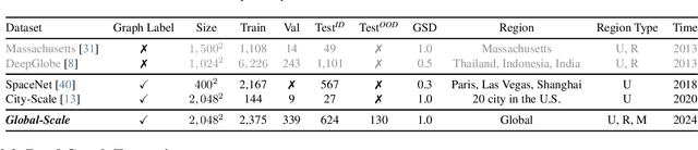
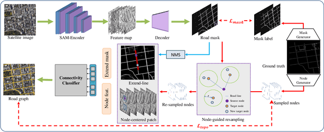
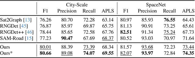

Recently, road graph extraction has garnered increasing attention due to its crucial role in autonomous driving, navigation, etc. However, accurately and efficiently extracting road graphs remains a persistent challenge, primarily due to the severe scarcity of labeled data. To address this limitation, we collect a global-scale satellite road graph extraction dataset, i.e. Global-Scale dataset. Specifically, the Global-Scale dataset is $\sim20 \times$ larger than the largest existing public road extraction dataset and spans over 13,800 $km^2$ globally. Additionally, we develop a novel road graph extraction model, i.e. SAM-Road++, which adopts a node-guided resampling method to alleviate the mismatch issue between training and inference in SAM-Road, a pioneering state-of-the-art road graph extraction model. Furthermore, we propose a simple yet effective ``extended-line'' strategy in SAM-Road++ to mitigate the occlusion issue on the road. Extensive experiments demonstrate the validity of the collected Global-Scale dataset and the proposed SAM-Road++ method, particularly highlighting its superior predictive power in unseen regions. The dataset and code are available at \url{https://github.com/earth-insights/samroadplus}.