 Add to Chrome
 Add to Firefox
 Add to Edge
Driver2Map: Imitating Human Driving for Online High-Definition Map Construction
Aug 02, 2026
High-definition (HD) maps are essential for autonomous driving systems. In constructing such maps, onboard multi-view camera images, standard-definition maps and satellite images provide crucial information. However, due to the modality and perspective differences among these data sources, existing methods often struggle to effectively align and fuse them, making online HD map construction still challenging. To address these issues, we propose Driver2Map, an online HD map construction model inspired by human drivers. Unlike existing HD map construction models that utilize only two modalities, our Driver2Map can simultaneously exploit three modalities. Specifically, we propose a "two-stage alignment" strategy to reduce spatial misalignment across different modalities. Additionally, we introduce "Pose-Guided BEV Fusion", a BEV (bird's-eye-view) generation module that leverages camera pose information to adaptively weight multi-view features, thereby effectively suppressing cross-view feature overlap during BEV generation. Also, we design a "Pretrained Prior for Map Refinement" module to refine the initial prediction by learning map structure priors, thus improving the HD map prediction under dynamic occlusions. Extensive experiments demonstrate that Driver2Map outperforms existing methods on both IoU and AP metrics.

Towards Satellite Image Road Graph Extraction: A Global-Scale Dataset and A Novel Method
Nov 23, 2024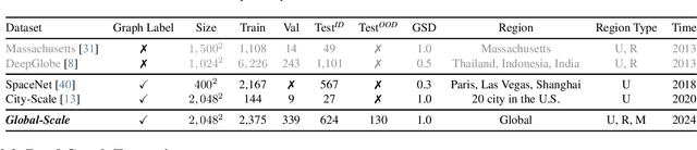
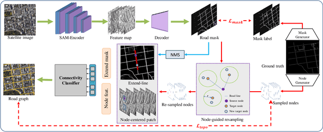
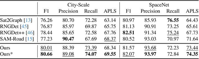

Recently, road graph extraction has garnered increasing attention due to its crucial role in autonomous driving, navigation, etc. However, accurately and efficiently extracting road graphs remains a persistent challenge, primarily due to the severe scarcity of labeled data. To address this limitation, we collect a global-scale satellite road graph extraction dataset, i.e. Global-Scale dataset. Specifically, the Global-Scale dataset is $\sim20 \times$ larger than the largest existing public road extraction dataset and spans over 13,800 $km^2$ globally. Additionally, we develop a novel road graph extraction model, i.e. SAM-Road++, which adopts a node-guided resampling method to alleviate the mismatch issue between training and inference in SAM-Road, a pioneering state-of-the-art road graph extraction model. Furthermore, we propose a simple yet effective ``extended-line'' strategy in SAM-Road++ to mitigate the occlusion issue on the road. Extensive experiments demonstrate the validity of the collected Global-Scale dataset and the proposed SAM-Road++ method, particularly highlighting its superior predictive power in unseen regions. The dataset and code are available at \url{https://github.com/earth-insights/samroadplus}.