 Add to Chrome
 Add to Firefox
 Add to Edge
Modulation Consistency-based Contrastive Learning for Self-Supervised Automatic Modulation Classification
May 12, 2026
Deep learning-based AMC methods have achieved remarkable performance, but their practical deployment remains constrained by the high cost of labeled data. Although self-supervised learning (SSL) reduces the reliance on labels, existing SSL-based AMC methods often rely on task-agnostic pretext objectives misaligned with modulation classification, leading to representations entangled with nuisance factors such as symbol, channel, and noise. In this paper, we identify intra-instance modulation consistency as a task-aware structural prior, whereby different temporal segments of the same signal may differ in waveform while preserving the same modulation type, thus providing a principled cue for task-aligned self-supervision. Based on this prior, we propose Mod-CL, a Modulation consistency-based Contrastive Learning framework that constructs positive pairs from different temporal segments of the same signal instance, to encourage the model to learn shared modulation information while suppressing nuisance variations. We further develop a contrastive objective tailored to Mod-CL, which jointly exploits temporal segmentation and data augmentation to pull together views sharing the same modulation semantics while avoiding supervisory conflicts within each signal instance. Extensive experiments on RadioML datasets show that Mod-CL consistently outperforms strong baselines, especially in low-label regimes, achieving substantial improvements in linear probing accuracy.

TAR: Text Semantic Assisted Cross-modal Image Registration Framework for Optical and SAR Images
May 12, 2026Existing deep learning-based methods can capture shared features from optical and synthetic aperture radar (SAR) images for spatial alignment. However, optical-SAR registration remains challenging under large geometric deformations, because the model needs to simultaneously handle cross-modal appearance discrepancies and complex spatial transformations. To address this issue, this paper proposes a text semantic-assisted cross-modal image registration framework, named TAR, for optical and SAR images. TAR exploits text semantic priors from remote sensing scenes and land-cover categories to alleviate the modality gap and enhance cross-modal feature learning. TAR consists of three components: a multi-scale visual feature learning (MSFL) module, a text-assisted feature enhancement (TAFE) module, and a coarse-to-fine dense matching (CFDM) module. MSFL extracts multi-scale visual features from optical and SAR images. TAFE constructs text descriptors related to remote sensing scenes and land-cover objects, and uses a frozen RemoteCLIP text encoder to extract text features. These text features are introduced through visual-text interaction to enhance high-level visual features for more reliable coarse matching. CFDM then establishes coarse correspondences based on the enhanced high-level features and refines the matched locations using low-level features. Experimental results on cross-modal remote sensing images demonstrate the effectiveness of TAR, which achieves stronger matching performance than several state-of-the-art methods and yields significant gains under large geometric deformations.
BGG: Bridging the Geometric Gap between Cross-View images by Vision Foundation Model Adaptation for Geo-Localization
May 11, 2026Geometric differences between cross-view images, such as drone and satellite views, significantly increase the challenge of Cross-View Geo-Localization (CVGL), which aims to acquire the geolocation of images by image retrieval. To further enhance the CVGL performance, this paper proposes a parameter-efficient adaptation framework for bridging the geometric gap across images based on the vision foundation model (VFM) (e.g., DINOv3), termed BGG. BGG not only effectively leverages the general visual representations of VFM and captures the robust and consistent features from cross-view images, but also utilizes the generalization capabilities of the VFM, significantly improving the CVGL performance. It mainly contains a Multi-granularity Feature Enhancement Adapter (MFEA) and a Frequency-Aware Structural Aggregation (FASA) module. Specifically, MFEA enhances the scale adaptability and viewpoint robustness of features by multi-level dilated convolutions, effectively bridging the cross-view geometric gap with small training costs. Additionally, considering the [CLS] token lacks spatial details for precise image retrieval and localization, the FASA module modulates patch tokens in the frequency domain and performs adaptive aggregation for local structural feature enhancement. Finally, BGG fuses the enhanced local features with the [CLS] token for more accurate CVGL. Extensive experiments on University-1652 and SUES-200 datasets demonstrate that BGG has significant advantages over other methods and achieves state-of-the-art localization performance with low training costs.
Learning What Matters Now: Dynamic Preference Inference under Contextual Shifts
Mar 24, 2026Humans often juggle multiple, sometimes conflicting objectives and shift their priorities as circumstances change, rather than following a fixed objective function. In contrast, most computational decision-making and multi-objective RL methods assume static preference weights or a known scalar reward. In this work, we study sequential decision-making problem when these preference weights are unobserved latent variables that drift with context. Specifically, we propose Dynamic Preference Inference (DPI), a cognitively inspired framework in which an agent maintains a probabilistic belief over preference weights, updates this belief from recent interaction, and conditions its policy on inferred preferences. We instantiate DPI as a variational preference inference module trained jointly with a preference-conditioned actor-critic, using vector-valued returns as evidence about latent trade-offs. In queueing, maze, and multi-objective continuous-control environments with event-driven changes in objectives, DPI adapts its inferred preferences to new regimes and achieves higher post-shift performance than fixed-weight and heuristic envelope baselines.
Generalizable Knowledge Distillation from Vision Foundation Models for Semantic Segmentation
Mar 03, 2026Knowledge distillation (KD) has been widely applied in semantic segmentation to compress large models, but conventional approaches primarily preserve in-domain accuracy while neglecting out-of-domain generalization, which is essential under distribution shifts. This limitation becomes more severe with the emergence of vision foundation models (VFMs): although VFMs exhibit strong robustness on unseen data, distilling them with conventional KD often compromises this ability. We propose Generalizable Knowledge Distillation (GKD), a multi-stage framework that explicitly enhances generalization. GKD decouples representation learning from task learning. In the first stage, the student acquires domain-agnostic representations through selective feature distillation, and in the second stage, these representations are frozen for task adaptation, thereby mitigating overfitting to visible domains. To further support transfer, we introduce a query-based soft distillation mechanism, where student features act as queries to teacher representations to selectively retrieve transferable spatial knowledge from VFMs. Extensive experiments on five domain generalization benchmarks demonstrate that GKD consistently outperforms existing KD methods, achieving average gains of +1.9% in foundation-to-foundation (F2F) and +10.6% in foundation-to-local (F2L) distillation. The code will be available at https://github.com/Younger-hua/GKD.
SpecFuse: A Spectral-Temporal Fusion Predictive Control Framework for UAV Landing on Oscillating Marine Platforms
Feb 17, 2026Autonomous landing of Uncrewed Aerial Vehicles (UAVs) on oscillating marine platforms is severely constrained by wave-induced multi-frequency oscillations, wind disturbances, and prediction phase lags in motion prediction. Existing methods either treat platform motion as a general random process or lack explicit modeling of wave spectral characteristics, leading to suboptimal performance under dynamic sea conditions. To address these limitations, we propose SpecFuse: a novel spectral-temporal fusion predictive control framework that integrates frequency-domain wave decomposition with time-domain recursive state estimation for high-precision 6-DoF motion forecasting of Uncrewed Surface Vehicles (USVs). The framework explicitly models dominant wave harmonics to mitigate phase lags, refining predictions in real time via IMU data without relying on complex calibration. Additionally, we design a hierarchical control architecture featuring a sampling-based HPO-RRT* algorithm for dynamic trajectory planning under non-convex constraints and a learning-augmented predictive controller that fuses data-driven disturbance compensation with optimization-based execution. Extensive validations (2,000 simulations + 8 lake experiments) show our approach achieves a 3.2 cm prediction error, 4.46 cm landing deviation, 98.7% / 87.5% success rates (simulation / real-world), and 82 ms latency on embedded hardware, outperforming state-of-the-art methods by 44%-48% in accuracy. Its robustness to wave-wind coupling disturbances supports critical maritime missions such as search and rescue and environmental monitoring. All code, experimental configurations, and datasets will be released as open-source to facilitate reproducibility.
CLNet: Cross-View Correspondence Makes a Stronger Geo-Localizationer
Dec 16, 2025Image retrieval-based cross-view geo-localization (IRCVGL) aims to match images captured from significantly different viewpoints, such as satellite and street-level images. Existing methods predominantly rely on learning robust global representations or implicit feature alignment, which often fail to model explicit spatial correspondences crucial for accurate localization. In this work, we propose a novel correspondence-aware feature refinement framework, termed CLNet, that explicitly bridges the semantic and geometric gaps between different views. CLNet decomposes the view alignment process into three learnable and complementary modules: a Neural Correspondence Map (NCM) that spatially aligns cross-view features via latent correspondence fields; a Nonlinear Embedding Converter (NEC) that remaps features across perspectives using an MLP-based transformation; and a Global Feature Recalibration (GFR) module that reweights informative feature channels guided by learned spatial cues. The proposed CLNet can jointly capture both high-level semantics and fine-grained alignments. Extensive experiments on four public benchmarks, CVUSA, CVACT, VIGOR, and University-1652, demonstrate that our proposed CLNet achieves state-of-the-art performance while offering better interpretability and generalizability.
Semantic Localization Guiding Segment Anything Model For Reference Remote Sensing Image Segmentation
Jun 12, 2025The Reference Remote Sensing Image Segmentation (RRSIS) task generates segmentation masks for specified objects in images based on textual descriptions, which has attracted widespread attention and research interest. Current RRSIS methods rely on multi-modal fusion backbones and semantic segmentation heads but face challenges like dense annotation requirements and complex scene interpretation. To address these issues, we propose a framework named \textit{prompt-generated semantic localization guiding Segment Anything Model}(PSLG-SAM), which decomposes the RRSIS task into two stages: coarse localization and fine segmentation. In coarse localization stage, a visual grounding network roughly locates the text-described object. In fine segmentation stage, the coordinates from the first stage guide the Segment Anything Model (SAM), enhanced by a clustering-based foreground point generator and a mask boundary iterative optimization strategy for precise segmentation. Notably, the second stage can be train-free, significantly reducing the annotation data burden for the RRSIS task. Additionally, decomposing the RRSIS task into two stages allows for focusing on specific region segmentation, avoiding interference from complex scenes.We further contribute a high-quality, multi-category manually annotated dataset. Experimental validation on two datasets (RRSIS-D and RRSIS-M) demonstrates that PSLG-SAM achieves significant performance improvements and surpasses existing state-of-the-art models.Our code will be made publicly available.
Lightweight Adapter Learning for More Generalized Remote Sensing Change Detection
Apr 28, 2025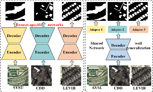

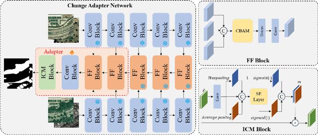
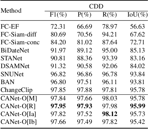
Deep learning methods have shown promising performances in remote sensing image change detection (CD). However, existing methods usually train a dataset-specific deep network for each dataset. Due to the significant differences in the data distribution and labeling between various datasets, the trained dataset-specific deep network has poor generalization performances on other datasets. To solve this problem, this paper proposes a change adapter network (CANet) for a more universal and generalized CD. CANet contains dataset-shared and dataset-specific learning modules. The former explores the discriminative features of images, and the latter designs a lightweight adapter model, to deal with the characteristics of different datasets in data distribution and labeling. The lightweight adapter can quickly generalize the deep network for new CD tasks with a small computation cost. Specifically, this paper proposes an interesting change region mask (ICM) in the adapter, which can adaptively focus on interested change objects and decrease the influence of labeling differences in various datasets. Moreover, CANet adopts a unique batch normalization layer for each dataset to deal with data distribution differences. Compared with existing deep learning methods, CANet can achieve satisfactory CD performances on various datasets simultaneously. Experimental results on several public datasets have verified the effectiveness and advantages of the proposed CANet on CD. CANet has a stronger generalization ability, smaller training costs (merely updating 4.1%-7.7% parameters), and better performances under limited training datasets than other deep learning methods, which also can be flexibly inserted with existing deep models.
Electricity Cost Minimization for Multi-Workflow Allocation in Geo-Distributed Data Centers
Apr 27, 2025Worldwide, Geo-distributed Data Centers (GDCs) provide computing and storage services for massive workflow applications, resulting in high electricity costs that vary depending on geographical locations and time. How to reduce electricity costs while satisfying the deadline constraints of workflow applications is important in GDCs, which is determined by the execution time of servers, power, and electricity price. Determining the completion time of workflows with different server frequencies can be challenging, especially in scenarios with heterogeneous computing resources in GDCs. Moreover, the electricity price is also different in geographical locations and may change dynamically. To address these challenges, we develop a geo-distributed system architecture and propose an Electricity Cost aware Multiple Workflows Scheduling algorithm (ECMWS) for servers of GDCs with fixed frequency and power. ECMWS comprises four stages, namely workflow sequencing, deadline partitioning, task sequencing, and resource allocation where two graph embedding models and a policy network are constructed to solve the Markov Decision Process (MDP). After statistically calibrating parameters and algorithm components over a comprehensive set of workflow instances, the proposed algorithms are compared with the state-of-the-art methods over two types of workflow instances. The experimental results demonstrate that our proposed algorithm significantly outperforms other algorithms, achieving an improvement of over 15\% while maintaining an acceptable computational time. The source codes are available at https://gitee.com/public-artifacts/ecmws-experiments.