 Add to Chrome
 Add to Firefox
 Add to Edge
UNSEEN: Uncertainty-aware Navigation via Sparse Estimation in Unknown Environments
Jun 18, 2026Visual navigation in unknown environments remains a core challenge in mobile robotics, especially for resource-constrained platforms. Most existing approaches rely on loosely coupled modular pipelines and strong assumptions on perception quality or environmental structure, often resorting to multi-modal sensor suites that increase system complexity and deployment cost. Vision-only navigation offers a lightweight alternative, but its performance degrades severely under motion blur, low texture, and illumination changes, largely because they neglect the tight coupling between commanded motion and perception. While perception-aware methods partially address this issue, they typically optimize individual modules and fail to propagate uncertainty consistently across the navigation stack. In this paper, we present UNSEEN, a unified uncertainty- and perception-aware navigation framework that explicitly couples localization, mapping, and planning using only a front-mounted camera. UNSEEN estimates sparse maps and robot poses with associated uncertainties at 6Hz, and leverages them to plan trajectories that jointly optimize task progress and estimation accuracy in receding-horizon. Simulations and extensive real-world experiments in unknown environments demonstrate the robustness of the proposed approach, with UNSEEN-SLAM reducing absolute translational error by 9.8% and UNSEEN-Plan improving estimation accuracy by up to 45% compared to state-of-the-art methods, while achieving a 100% task success rate.
DigiForest: Digital Analytics and Robotics for Sustainable Forestry
Apr 16, 2026Covering one third of Earth's land surface, forests are vital to global biodiversity, climate regulation, and human well-being. In Europe, forests and woodlands reach approximately 40% of land area, and the forestry sector is central to achieving the EU's climate neutrality and biodiversity goals; these emphasize sustainable forest management, increased use of long-lived wood products, and resilient forest ecosystems. To meet these goals and properly address their inherent challenges, current practices require further innovation. This chapter introduces DigiForest, a novel, large-scale precision forestry approach leveraging digital technologies and autonomous robotics. DigiForest is structured around four main components: (1) autonomous, heterogeneous mobile robots (aerial, legged, and marsupial) for tree-level data collection; (2) automated extraction of tree traits to build forest inventories; (3) a Decision Support System (DSS) for forecasting forest growth and supporting decision-making; and (4) low-impact selective logging using purpose-built autonomous harvesters. These technologies have been extensively validated in real-world conditions in several locations, including forests in Finland, the UK, and Switzerland.
A multi-platform LiDAR dataset for standardized forest inventory measurement at long term ecological monitoring sites
Apr 16, 2026We present a curated multi-platform LiDAR reference dataset from an instrumented ICOS forest plot, explicitly designed to support calibration, benchmarking, and integration of 3D structural data with ecological observations and standard allometric models. The dataset integrates UAV-borne laser scanning (ULS) to measure canopy coverage, terrestrial laser scanning (TLS) for detailed stem mapping, and backpack mobile laser scanning (MLS) with real-time SLAM for efficient sub-canopy acquisition. We focus on the control plot with the most complete and internally consistent registration, where TLS point clouds (~333 million points) are complemented by ULS and MLS data capturing canopy and understory strata. Marker-free, SLAM-aware protocols were used to reduce field and processing time, while manual and automated methods were combined. Final products are available in LAZ and E57 formats with UTM coordinates, together with registration reports for reproducibility. The dataset provides a benchmark for testing registration methods, evaluating scanning efficiency, and linking point clouds with segmentation, quantitative structure models, and allometric biomass estimation. By situating the acquisitions at a long-term ICOS site, it is explicitly linked to 3D structure with decades of ecological and flux measurements. More broadly, it illustrates how TLS, MLS, and ULS can be combined for repeated inventories and digital twins of forest ecosystems.
3D Freehand Ultrasound using Visual Inertial and Deep Inertial Odometry for Measuring Patellar Tracking
Apr 24, 2024Patellofemoral joint (PFJ) issues affect one in four people, with 20% experiencing chronic knee pain despite treatment. Poor outcomes and pain after knee replacement surgery are often linked to patellar mal-tracking. Traditional imaging methods like CT and MRI face challenges, including cost and metal artefacts, and there's currently no ideal way to observe joint motion without issues such as soft tissue artefacts or radiation exposure. A new system to monitor joint motion could significantly improve understanding of PFJ dynamics, aiding in better patient care and outcomes. Combining 2D ultrasound with motion tracking for 3D reconstruction of the joint using semantic segmentation and position registration can be a solution. However, the need for expensive external infrastructure to estimate the trajectories of the scanner remains the main limitation to implementing 3D bone reconstruction from handheld ultrasound scanning clinically. We proposed the Visual-Inertial Odometry (VIO) and the deep learning-based inertial-only odometry methods as alternatives to motion capture for tracking a handheld ultrasound scanner. The 3D reconstruction generated by these methods has demonstrated potential for assessing the PFJ and for further measurements from free-hand ultrasound scans. The results show that the VIO method performs as well as the motion capture method, with average reconstruction errors of 1.25 mm and 1.21 mm, respectively. The VIO method is the first infrastructure-free method for 3D reconstruction of bone from wireless handheld ultrasound scanning with an accuracy comparable to methods that require external infrastructure.
Deep IMU Bias Inference for Robust Visual-Inertial Odometry with Factor Graphs
Nov 08, 2022


Visual Inertial Odometry (VIO) is one of the most established state estimation methods for mobile platforms. However, when visual tracking fails, VIO algorithms quickly diverge due to rapid error accumulation during inertial data integration. This error is typically modeled as a combination of additive Gaussian noise and a slowly changing bias which evolves as a random walk. In this work, we propose to train a neural network to learn the true bias evolution. We implement and compare two common sequential deep learning architectures: LSTMs and Transformers. Our approach follows from recent learning-based inertial estimators, but, instead of learning a motion model, we target IMU bias explicitly, which allows us to generalize to locomotion patterns unseen in training. We show that our proposed method improves state estimation in visually challenging situations across a wide range of motions by quadrupedal robots, walking humans, and drones. Our experiments show an average 15% reduction in drift rate, with much larger reductions when there is total vision failure. Importantly, we also demonstrate that models trained with one locomotion pattern (human walking) can be applied to another (quadruped robot trotting) without retraining.
Factor Graph Fusion of Raw GNSS Sensing with IMU and Lidar for Precise Robot Localization without a Base Station
Oct 05, 2022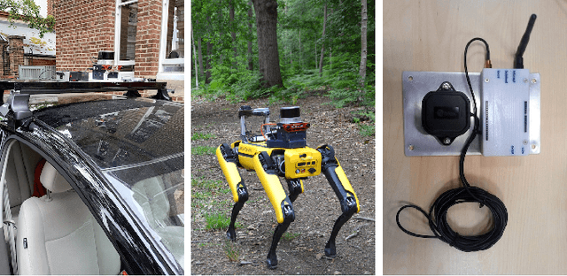
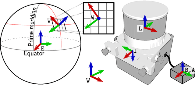
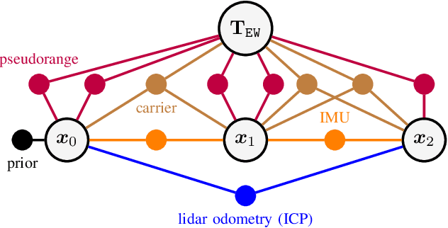
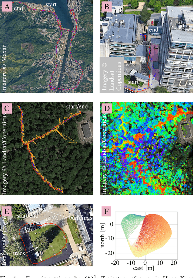
Accurate localization is a core component of a robot's navigation system. To this end, global navigation satellite systems (GNSS) can provide absolute measurements outdoors and, therefore, eliminate long-term drift. However, fusing GNSS data with other sensor data is not trivial, especially when a robot moves between areas with and without sky view. We propose a robust approach that tightly fuses raw GNSS receiver data with inertial measurements and, optionally, lidar observations for precise and smooth mobile robot localization. A factor graph with two types of GNSS factors is proposed. First, factors based on pseudoranges, which allow for global localization on Earth. Second, factors based on carrier phases, which enable highly accurate relative localization, which is useful when other sensing modalities are challenged. Unlike traditional differential GNSS, this approach does not require a connection to a base station. On a public urban driving dataset, our approach achieves accuracy comparable to a state-of-the-art algorithm that fuses visual inertial odometry with GNSS data -- despite our approach not using the camera, just inertial and GNSS data. We also demonstrate the robustness of our approach using data from a car and a quadruped robot moving in environments with little sky visibility, such as a forest. The accuracy in the global Earth frame is still 1-2 m, while the estimated trajectories are discontinuity-free and smooth. We also show how lidar measurements can be tightly integrated. We believe this is the first system that fuses raw GNSS observations (as opposed to fixes) with lidar.
Hilti-Oxford Dataset: A Millimetre-Accurate Benchmark for Simultaneous Localization and Mapping
Aug 21, 2022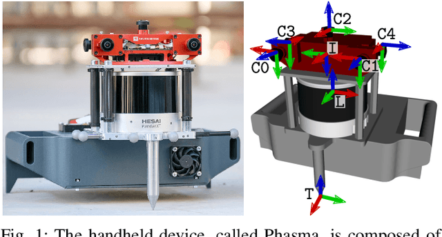

Simultaneous Localization and Mapping (SLAM) is being deployed in real-world applications, however many state-of-the-art solutions still struggle in many common scenarios. A key necessity in progressing SLAM research is the availability of high-quality datasets and fair and transparent benchmarking. To this end, we have created the Hilti-Oxford Dataset, to push state-of-the-art SLAM systems to their limits. The dataset has a variety of challenges ranging from sparse and regular construction sites to a 17th century neoclassical building with fine details and curved surfaces. To encourage multi-modal SLAM approaches, we designed a data collection platform featuring a lidar, five cameras, and an IMU (Inertial Measurement Unit). With the goal of benchmarking SLAM algorithms for tasks where accuracy and robustness are paramount, we implemented a novel ground truth collection method that enables our dataset to accurately measure SLAM pose errors with millimeter accuracy. To further ensure accuracy, the extrinsics of our platform were verified with a micrometer-accurate scanner, and temporal calibration was managed online using hardware time synchronization. The multi-modality and diversity of our dataset attracted a large field of academic and industrial researchers to enter the second edition of the Hilti SLAM challenge, which concluded in June 2022. The results of the challenge show that while the top three teams could achieve accuracy of 2cm or better for some sequences, the performance dropped off in more difficult sequences.
Team CERBERUS Wins the DARPA Subterranean Challenge: Technical Overview and Lessons Learned
Jul 11, 2022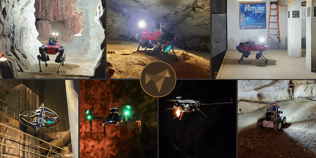
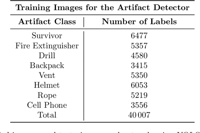
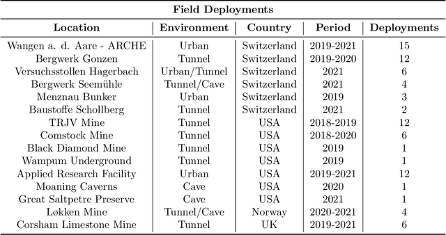
This article presents the CERBERUS robotic system-of-systems, which won the DARPA Subterranean Challenge Final Event in 2021. The Subterranean Challenge was organized by DARPA with the vision to facilitate the novel technologies necessary to reliably explore diverse underground environments despite the grueling challenges they present for robotic autonomy. Due to their geometric complexity, degraded perceptual conditions combined with lack of GPS support, austere navigation conditions, and denied communications, subterranean settings render autonomous operations particularly demanding. In response to this challenge, we developed the CERBERUS system which exploits the synergy of legged and flying robots, coupled with robust control especially for overcoming perilous terrain, multi-modal and multi-robot perception for localization and mapping in conditions of sensor degradation, and resilient autonomy through unified exploration path planning and local motion planning that reflects robot-specific limitations. Based on its ability to explore diverse underground environments and its high-level command and control by a single human supervisor, CERBERUS demonstrated efficient exploration, reliable detection of objects of interest, and accurate mapping. In this article, we report results from both the preliminary runs and the final Prize Round of the DARPA Subterranean Challenge, and discuss highlights and challenges faced, alongside lessons learned for the benefit of the community.
CERBERUS: Autonomous Legged and Aerial Robotic Exploration in the Tunnel and Urban Circuits of the DARPA Subterranean Challenge
Jan 18, 2022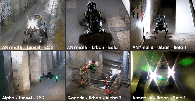
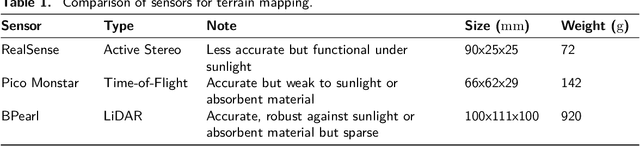
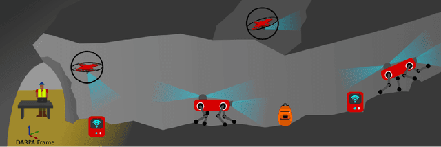
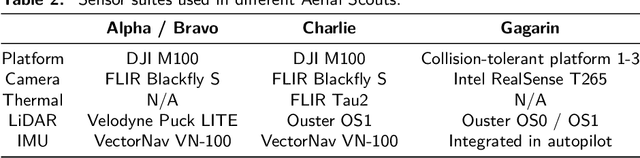
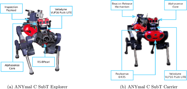
Autonomous exploration of subterranean environments constitutes a major frontier for robotic systems as underground settings present key challenges that can render robot autonomy hard to achieve. This has motivated the DARPA Subterranean Challenge, where teams of robots search for objects of interest in various underground environments. In response, the CERBERUS system-of-systems is presented as a unified strategy towards subterranean exploration using legged and flying robots. As primary robots, ANYmal quadruped systems are deployed considering their endurance and potential to traverse challenging terrain. For aerial robots, both conventional and collision-tolerant multirotors are utilized to explore spaces too narrow or otherwise unreachable by ground systems. Anticipating degraded sensing conditions, a complementary multi-modal sensor fusion approach utilizing camera, LiDAR, and inertial data for resilient robot pose estimation is proposed. Individual robot pose estimates are refined by a centralized multi-robot map optimization approach to improve the reported location accuracy of detected objects of interest in the DARPA-defined coordinate frame. Furthermore, a unified exploration path planning policy is presented to facilitate the autonomous operation of both legged and aerial robots in complex underground networks. Finally, to enable communication between the robots and the base station, CERBERUS utilizes a ground rover with a high-gain antenna and an optical fiber connection to the base station, alongside breadcrumbing of wireless nodes by our legged robots. We report results from the CERBERUS system-of-systems deployment at the DARPA Subterranean Challenge Tunnel and Urban Circuits, along with the current limitations and the lessons learned for the benefit of the community.
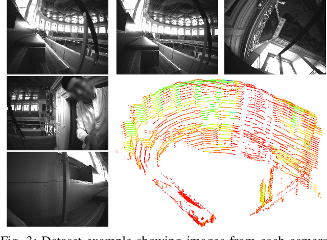
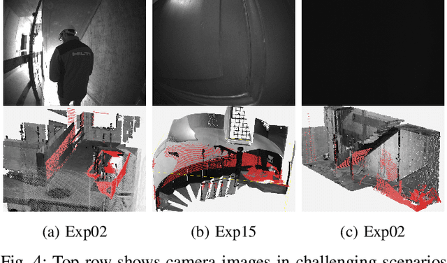
Multi-Camera LiDAR Inertial Extension to the Newer College Dataset
Dec 16, 2021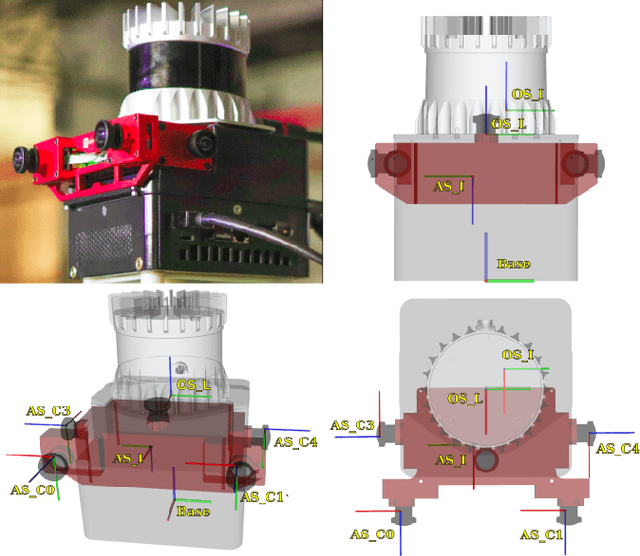
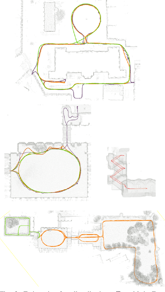
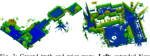
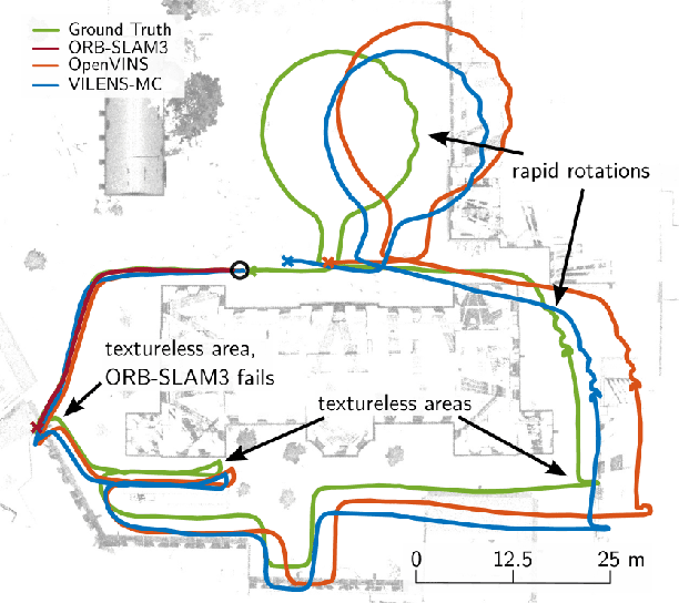
In this paper, we present a multi-camera LiDAR inertial dataset of 4.5km walking distance as an expansion to the Newer College Dataset. The global shutter multi-camera device is hardware synchronized with the IMU and the LiDAR. This dataset also provides six Degrees of Freedom (DoF) ground truth poses, at the LiDAR frequency of 10hz. Three data collections are described and example usage of multi-camera visual-inertial odometry is demonstrated. This expansion dataset contains small and narrow passages, large scale open spaces as well as vegetated areas to test localization and mapping systems. Furthermore, some sequences present challenging situations such as abrupt lighting change, textureless surfaces, and aggressive motion. The dataset is available at: https://ori-drs.github.io/newer-college-dataset