 Add to Chrome
 Add to Firefox
 Add to Edge
More Diverse Means Better: Multimodal Deep Learning Meets Remote Sensing Imagery Classification
Aug 12, 2020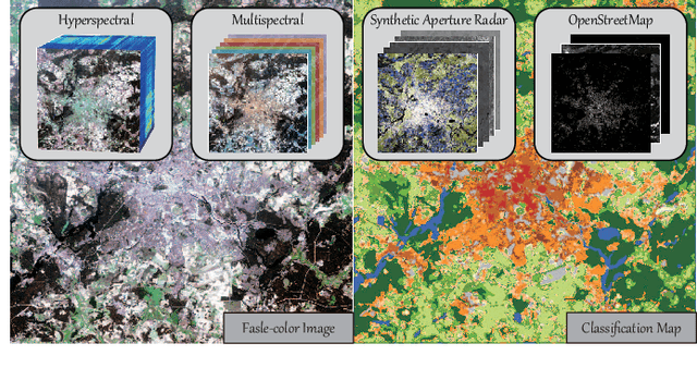
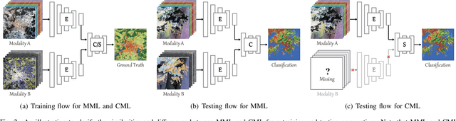
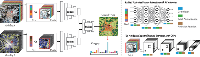
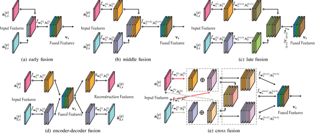
Classification and identification of the materials lying over or beneath the Earth's surface have long been a fundamental but challenging research topic in geoscience and remote sensing (RS) and have garnered a growing concern owing to the recent advancements of deep learning techniques. Although deep networks have been successfully applied in single-modality-dominated classification tasks, yet their performance inevitably meets the bottleneck in complex scenes that need to be finely classified, due to the limitation of information diversity. In this work, we provide a baseline solution to the aforementioned difficulty by developing a general multimodal deep learning (MDL) framework. In particular, we also investigate a special case of multi-modality learning (MML) -- cross-modality learning (CML) that exists widely in RS image classification applications. By focusing on "what", "where", and "how" to fuse, we show different fusion strategies as well as how to train deep networks and build the network architecture. Specifically, five fusion architectures are introduced and developed, further being unified in our MDL framework. More significantly, our framework is not only limited to pixel-wise classification tasks but also applicable to spatial information modeling with convolutional neural networks (CNNs). To validate the effectiveness and superiority of the MDL framework, extensive experiments related to the settings of MML and CML are conducted on two different multimodal RS datasets. Furthermore, the codes and datasets will be available at https://github.com/danfenghong/IEEE_TGRS_MDL-RS, contributing to the RS community.
Graph Convolutional Networks for Hyperspectral Image Classification
Aug 06, 2020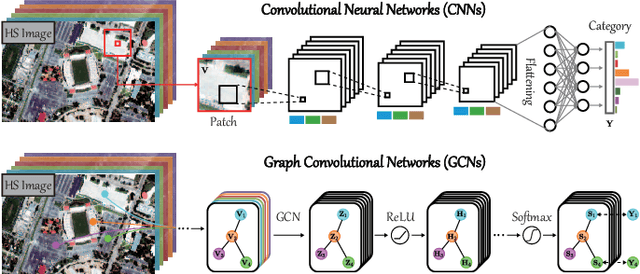
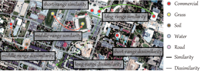
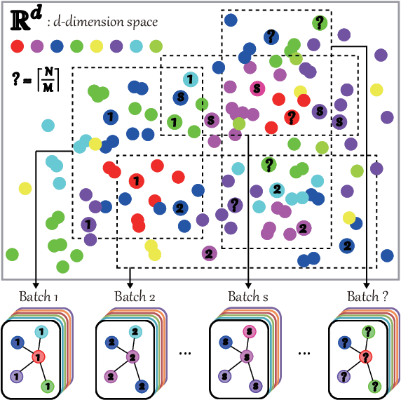
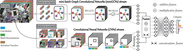
Convolutional neural networks (CNNs) have been attracting increasing attention in hyperspectral (HS) image classification, owing to their ability to capture spatial-spectral feature representations. Nevertheless, their ability in modeling relations between samples remains limited. Beyond the limitations of grid sampling, graph convolutional networks (GCNs) have been recently proposed and successfully applied in irregular (or non-grid) data representation and analysis. In this paper, we thoroughly investigate CNNs and GCNs (qualitatively and quantitatively) in terms of HS image classification. Due to the construction of the adjacency matrix on all the data, traditional GCNs usually suffer from a huge computational cost, particularly in large-scale remote sensing (RS) problems. To this end, we develop a new mini-batch GCN (called miniGCN hereinafter) which allows to train large-scale GCNs in a mini-batch fashion. More significantly, our miniGCN is capable of inferring out-of-sample data without re-training networks and improving classification performance. Furthermore, as CNNs and GCNs can extract different types of HS features, an intuitive solution to break the performance bottleneck of a single model is to fuse them. Since miniGCNs can perform batch-wise network training (enabling the combination of CNNs and GCNs) we explore three fusion strategies: additive fusion, element-wise multiplicative fusion, and concatenation fusion to measure the obtained performance gain. Extensive experiments, conducted on three HS datasets, demonstrate the advantages of miniGCNs over GCNs and the superiority of the tested fusion strategies with regards to the single CNN or GCN models. The codes of this work will be available at https://github.com/danfenghong/IEEE_TGRS_GCN for the sake of reproducibility.
Coupled Convolutional Neural Network with Adaptive Response Function Learning for Unsupervised Hyperspectral Super-Resolution
Jul 28, 2020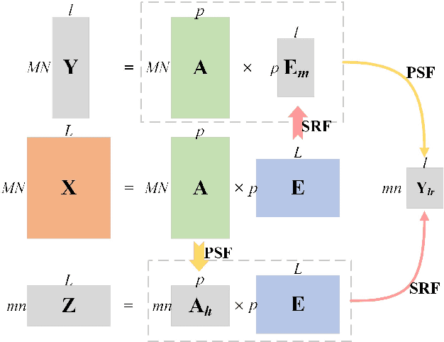
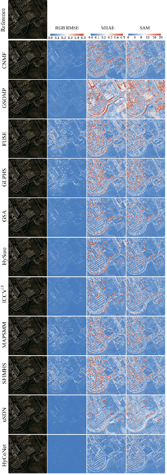
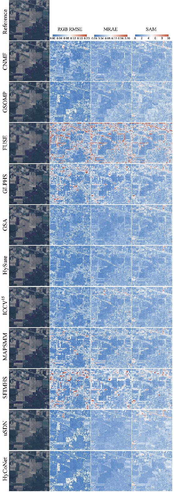
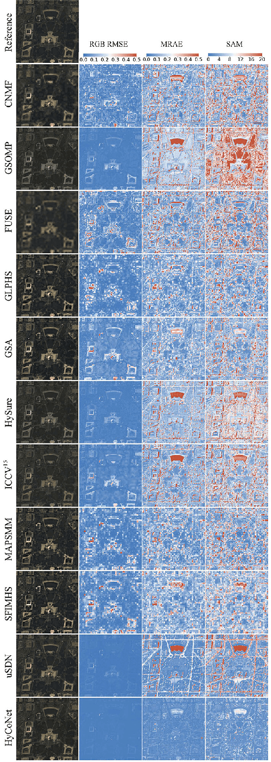
Due to the limitations of hyperspectral imaging systems, hyperspectral imagery (HSI) often suffers from poor spatial resolution, thus hampering many applications of the imagery. Hyperspectral super-resolution refers to fusing HSI and MSI to generate an image with both high spatial and high spectral resolutions. Recently, several new methods have been proposed to solve this fusion problem, and most of these methods assume that the prior information of the Point Spread Function (PSF) and Spectral Response Function (SRF) are known. However, in practice, this information is often limited or unavailable. In this work, an unsupervised deep learning-based fusion method - HyCoNet - that can solve the problems in HSI-MSI fusion without the prior PSF and SRF information is proposed. HyCoNet consists of three coupled autoencoder nets in which the HSI and MSI are unmixed into endmembers and abundances based on the linear unmixing model. Two special convolutional layers are designed to act as a bridge that coordinates with the three autoencoder nets, and the PSF and SRF parameters are learned adaptively in the two convolution layers during the training process. Furthermore, driven by the joint loss function, the proposed method is straightforward and easily implemented in an end-to-end training manner. The experiments performed in the study demonstrate that the proposed method performs well and produces robust results for different datasets and arbitrary PSFs and SRFs.
Spectral Superresolution of Multispectral Imagery with Joint Sparse and Low-Rank Learning
Jul 28, 2020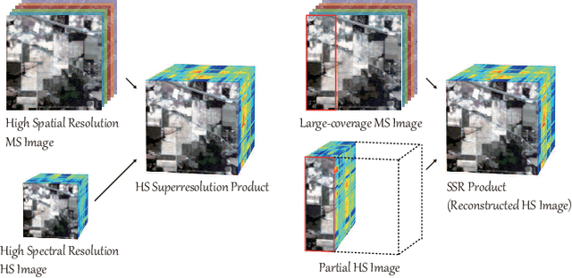
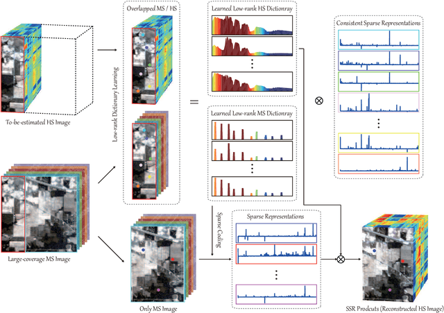
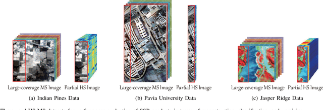
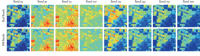
Extensive attention has been widely paid to enhance the spatial resolution of hyperspectral (HS) images with the aid of multispectral (MS) images in remote sensing. However, the ability in the fusion of HS and MS images remains to be improved, particularly in large-scale scenes, due to the limited acquisition of HS images. Alternatively, we super-resolve MS images in the spectral domain by the means of partially overlapped HS images, yielding a novel and promising topic: spectral superresolution (SSR) of MS imagery. This is challenging and less investigated task due to its high ill-posedness in inverse imaging. To this end, we develop a simple but effective method, called joint sparse and low-rank learning (J-SLoL), to spectrally enhance MS images by jointly learning low-rank HS-MS dictionary pairs from overlapped regions. J-SLoL infers and recovers the unknown hyperspectral signals over a larger coverage by sparse coding on the learned dictionary pair. Furthermore, we validate the SSR performance on three HS-MS datasets (two for classification and one for unmixing) in terms of reconstruction, classification, and unmixing by comparing with several existing state-of-the-art baselines, showing the effectiveness and superiority of the proposed J-SLoL algorithm. Furthermore, the codes and datasets will be available at: https://github.com/danfenghong/IEEE\_TGRS\_J-SLoL, contributing to the RS community.
Spatial-Spectral Manifold Embedding of Hyperspectral Data
Jul 17, 2020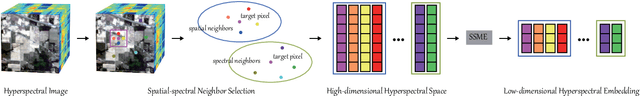
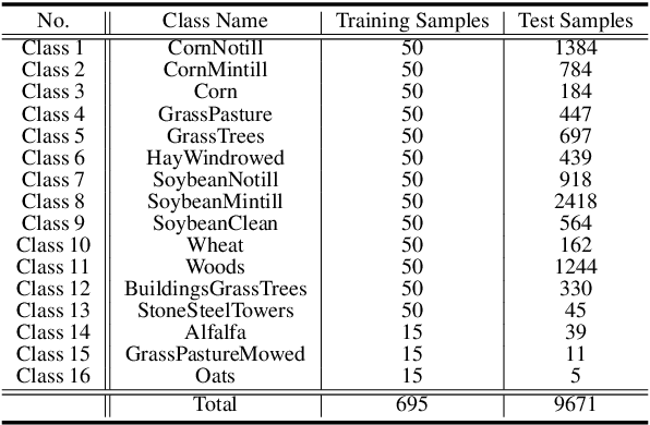
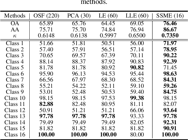
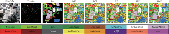
In recent years, hyperspectral imaging, also known as imaging spectroscopy, has been paid an increasing interest in geoscience and remote sensing community. Hyperspectral imagery is characterized by very rich spectral information, which enables us to recognize the materials of interest lying on the surface of the Earth more easier. We have to admit, however, that high spectral dimension inevitably brings some drawbacks, such as expensive data storage and transmission, information redundancy, etc. Therefore, to reduce the spectral dimensionality effectively and learn more discriminative spectral low-dimensional embedding, in this paper we propose a novel hyperspectral embedding approach by simultaneously considering spatial and spectral information, called spatial-spectral manifold embedding (SSME). Beyond the pixel-wise spectral embedding approaches, SSME models the spatial and spectral information jointly in a patch-based fashion. SSME not only learns the spectral embedding by using the adjacency matrix obtained by similarity measurement between spectral signatures, but also models the spatial neighbours of a target pixel in hyperspectral scene by sharing the same weights (or edges) in the process of learning embedding. Classification is explored as a potential strategy to quantitatively evaluate the performance of learned embedding representations. Classification is explored as a potential application for quantitatively evaluating the performance of these hyperspectral embedding algorithms. Extensive experiments conducted on the widely-used hyperspectral datasets demonstrate the superiority and effectiveness of the proposed SSME as compared to several state-of-the-art embedding methods.
Cross-Attention in Coupled Unmixing Nets for Unsupervised Hyperspectral Super-Resolution
Jul 15, 2020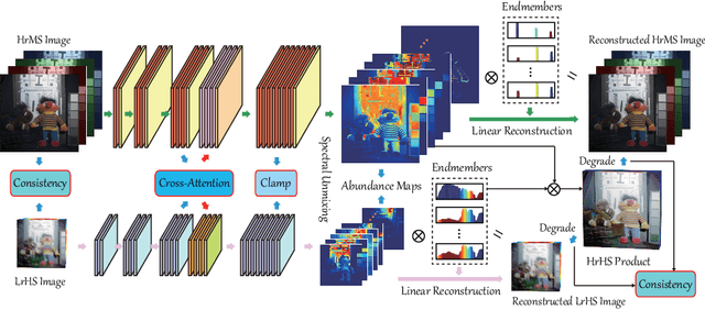
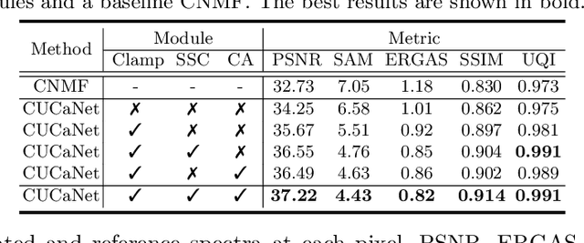
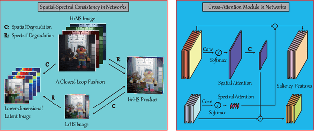
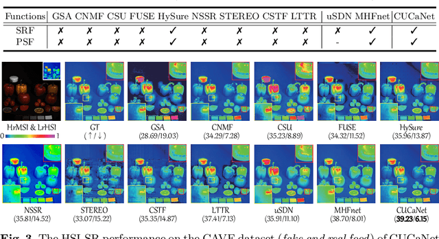
The recent advancement of deep learning techniques has made great progress on hyperspectral image super-resolution (HSI-SR). Yet the development of unsupervised deep networks remains challenging for this task. To this end, we propose a novel coupled unmixing network with a cross-attention mechanism, CUCaNet for short, to enhance the spatial resolution of HSI by means of higher-spatial-resolution multispectral image (MSI). Inspired by coupled spectral unmixing, a two-stream convolutional autoencoder framework is taken as backbone to jointly decompose MS and HS data into a spectrally meaningful basis and corresponding coefficients. CUCaNet is capable of adaptively learning spectral and spatial response functions from HS-MS correspondences by enforcing reasonable consistency assumptions on the networks. Moreover, a cross-attention module is devised to yield more effective spatial-spectral information transfer in networks. Extensive experiments are conducted on three widely-used HS-MS datasets in comparison with state-of-the-art HSI-SR models, demonstrating the superiority of the CUCaNet in the HSI-SR application. Furthermore, the codes and datasets will be available at: https://github.com/danfenghong/ECCV2020_CUCaNet.
X-ModalNet: A Semi-Supervised Deep Cross-Modal Network for Classification of Remote Sensing Data
Jul 11, 2020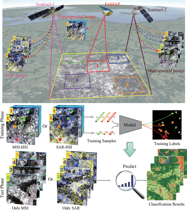
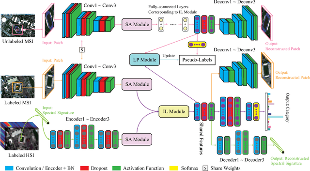
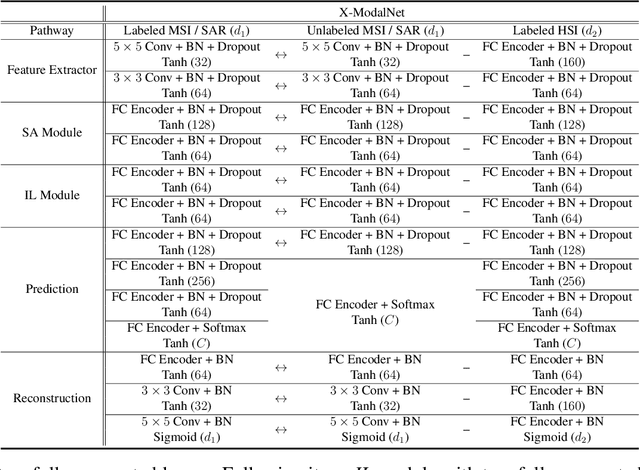
This paper addresses the problem of semi-supervised transfer learning with limited cross-modality data in remote sensing. A large amount of multi-modal earth observation images, such as multispectral imagery (MSI) or synthetic aperture radar (SAR) data, are openly available on a global scale, enabling parsing global urban scenes through remote sensing imagery. However, their ability in identifying materials (pixel-wise classification) remains limited, due to the noisy collection environment and poor discriminative information as well as limited number of well-annotated training images. To this end, we propose a novel cross-modal deep-learning framework, called X-ModalNet, with three well-designed modules: self-adversarial module, interactive learning module, and label propagation module, by learning to transfer more discriminative information from a small-scale hyperspectral image (HSI) into the classification task using a large-scale MSI or SAR data. Significantly, X-ModalNet generalizes well, owing to propagating labels on an updatable graph constructed by high-level features on the top of the network, yielding semi-supervised cross-modality learning. We evaluate X-ModalNet on two multi-modal remote sensing datasets (HSI-MSI and HSI-SAR) and achieve a significant improvement in comparison with several state-of-the-art methods.
Hyperspectral Image Super-resolution via Deep Spatio-spectral Convolutional Neural Networks
May 29, 2020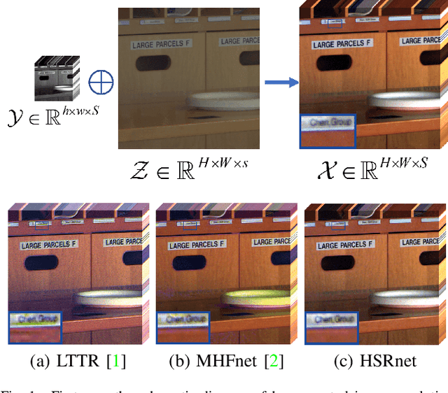
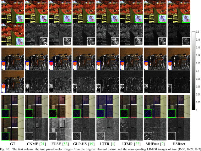
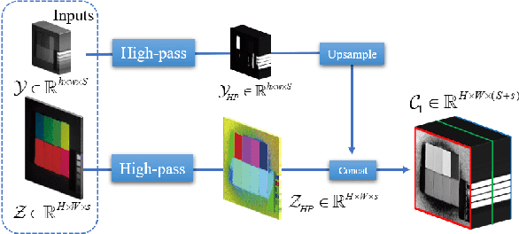
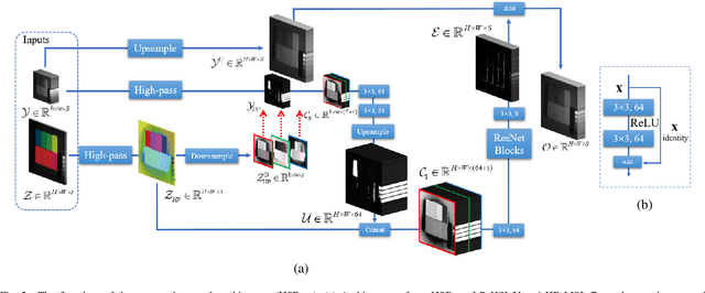
Hyperspectral images are of crucial importance in order to better understand features of different materials. To reach this goal, they leverage on a high number of spectral bands. However, this interesting characteristic is often paid by a reduced spatial resolution compared with traditional multispectral image systems. In order to alleviate this issue, in this work, we propose a simple and efficient architecture for deep convolutional neural networks to fuse a low-resolution hyperspectral image (LR-HSI) and a high-resolution multispectral image (HR-MSI), yielding a high-resolution hyperspectral image (HR-HSI). The network is designed to preserve both spatial and spectral information thanks to an architecture from two folds: one is to utilize the HR-HSI at a different scale to get an output with a satisfied spectral preservation; another one is to apply concepts of multi-resolution analysis to extract high-frequency information, aiming to output high quality spatial details. Finally, a plain mean squared error loss function is used to measure the performance during the training. Extensive experiments demonstrate that the proposed network architecture achieves best performance (both qualitatively and quantitatively) compared with recent state-of-the-art hyperspectral image super-resolution approaches. Moreover, other significant advantages can be pointed out by the use of the proposed approach, such as, a better network generalization ability, a limited computational burden, and a robustness with respect to the number of training samples.
Graph-based fusion for change detection in multi-spectral images
Apr 02, 2020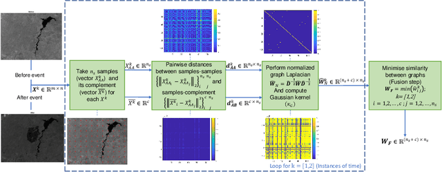

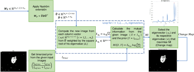
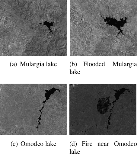
In this paper we address the problem of change detection in multi-spectral images by proposing a data-driven framework of graph-based data fusion. The main steps of the proposed approach are: (i) The generation of a multi-temporal pixel based graph, by the fusion of intra-graphs of each temporal data; (ii) the use of Nystr\"om extension to obtain the eigenvalues and eigenvectors of the fused graph, and the selection of the final change map. We validated our approach in two real cases of remote sensing according to both qualitative and quantitative analyses. The results confirm the potential of the proposed graph-based change detection algorithm outperforming state-of-the-art methods.
Feature Extraction for Hyperspectral Imagery: The Evolution from Shallow to Deep
Mar 06, 2020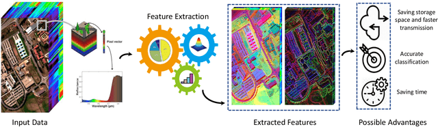
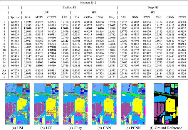
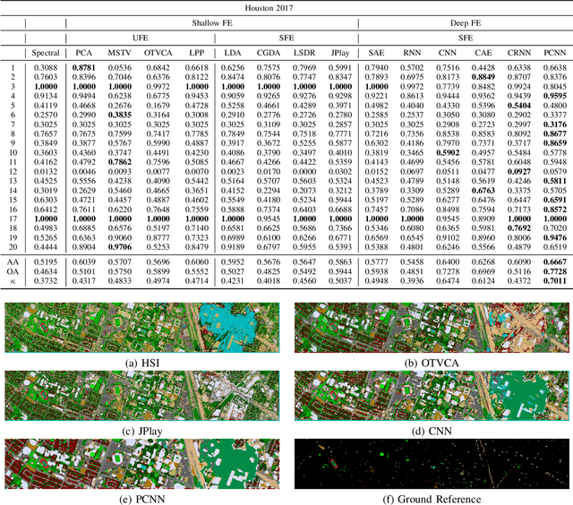
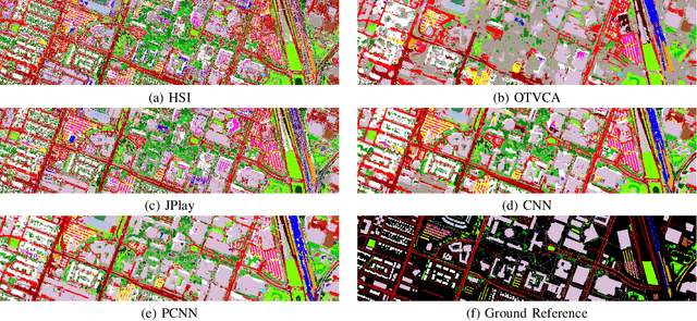
Hyperspectral images provide detailed spectral information through hundreds of (narrow) spectral channels (also known as dimensionality or bands) with continuous spectral information that can accurately classify diverse materials of interest. The increased dimensionality of such data makes it possible to significantly improve data information content but provides a challenge to the conventional techniques (the so-called curse of dimensionality) for accurate analysis of hyperspectral images. Feature extraction, as a vibrant field of research in the hyperspectral community, evolved through decades of research to address this issue and extract informative features suitable for data representation and classification. The advances in feature extraction have been inspired by two fields of research, including the popularization of image and signal processing as well as machine (deep) learning, leading to two types of feature extraction approaches named shallow and deep techniques. This article outlines the advances in feature extraction approaches for hyperspectral imagery by providing a technical overview of the state-of-the-art techniques, providing useful entry points for researchers at different levels, including students, researchers, and senior researchers, willing to explore novel investigations on this challenging topic. In more detail, this paper provides a bird's eye view over shallow (both supervised and unsupervised) and deep feature extraction approaches specifically dedicated to the topic of hyperspectral feature extraction and its application on hyperspectral image classification. Additionally, this paper compares 15 advanced techniques with an emphasis on their methodological foundations in terms of classification accuracies. Furthermore, the codes and libraries are shared at https://github.com/BehnoodRasti/HyFTech-Hyperspectral-Shallow-Deep-Feature-Extraction-Toolbox.