 Add to Chrome
 Add to Firefox
 Add to Edge
Monitoring Post-Disaster Urban Recovery Using High-Resolution SAR Time Series and Unsupervised Learning: Evidence from the 2023 Türkiye-Syria Earthquake
Jul 27, 2026
Monitoring post-disaster recovery is essential for understanding how urban systems rebuild and progressively return to functionality. However, tracking reconstruction remains difficult because reliable ground-truth information is often scarce and recovery processes evolve over time. This paper proposes an unsupervised framework for recovery monitoring based on multi-temporal synthetic aperture radar (SAR) observations and deep-learning anomaly detection. COSMO-SkyMed time series are used to identify persistent temporal anomalies associated with reconstruction activities and to generate spatially explicit recovery maps. The framework is applied to four cities severely affected by the 2023 Turkiye-Syria earthquakes, revealing heterogeneous reconstruction dynamics across different urban contexts. The results show spatially structured patterns of persistent anomalies related to reconstruction over damaged and cleared areas, temporary container settlements, and new residential districts. Comparison with nighttime-light recovery indicators derived from SDGSAT-1 data highlights the complementary nature of the two modalities: nighttime lights reflect the restoration of electricity supply and nighttime socioeconomic activity, whereas SAR anomalies capture structural changes in the built environment and may reveal reconstruction at earlier stages. The results demonstrate that multi-temporal SAR data combined with unsupervised learning provide an effective and scalable approach for monitoring post-disaster reconstruction when labeled recovery datasets are unavailable.

Context-Aware Slum Mapping in Sub-Saharan Africa Using Sentinel-1 Texture and Local Climate Zones
Jul 08, 2026Accurate mapping of informal settlements remains a major challenge in Sub-Saharan African (SSA) cities because optical imagery often fails to distinguish Informal Settlements (defined here as LCZ 7) from spectrally similar formal Compact Low-Rise areas (LCZ 3). This study presents a context-aware, reproducible Optical-SAR framework that improves informal settlement delineation using Sentinel-2 spectral features and Sentinel-1 structural information within an adapted Local Climate Zone (LCZ) taxonomy. We implement a three-tier SAR integration strategy: calibrated backscatter, GLCM textures, and a physics-guided feature engineered to capture the high structural disorder and weak radar return characteristic of SSA informal settlements. Using reference data across Nairobi and Eldoret (Kenya), we evaluate performance via a stratified hold-out protocol and a season-aware ablation study. Results show that SAR textures provide the dominant performance gain for LCZ 7 detection. The Optical-SAR model achieves overall accuracy of 0.816 (dry) and 0.807 (wet), significantly outperforming the WUDAPT baseline (OA 0.704) and reducing the critical LCZ 3 - LCZ 7 confusion to 7%. Seasonal analysis indicates that while optical-only separability varies with phenology, SAR-derived textures stabilize informal settlement mapping across seasons. These findings demonstrate that the incorporation of SAR-derived features yields consistent improvements for urban morphology mapping in data-scarce environments across seasons and across the evaluated source cities, while cross-city transfer remains limited without local adaptation strategies.
Hyperspectral Imaging
Aug 11, 2025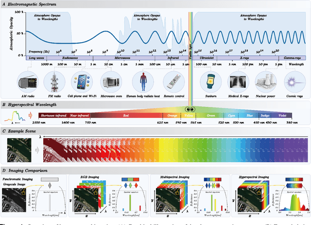
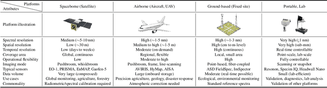
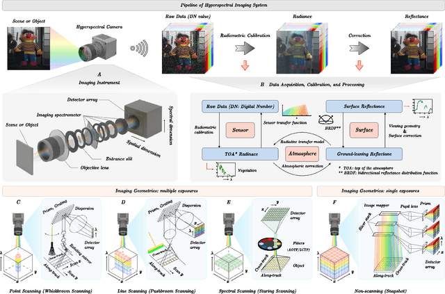

Hyperspectral imaging (HSI) is an advanced sensing modality that simultaneously captures spatial and spectral information, enabling non-invasive, label-free analysis of material, chemical, and biological properties. This Primer presents a comprehensive overview of HSI, from the underlying physical principles and sensor architectures to key steps in data acquisition, calibration, and correction. We summarize common data structures and highlight classical and modern analysis methods, including dimensionality reduction, classification, spectral unmixing, and AI-driven techniques such as deep learning. Representative applications across Earth observation, precision agriculture, biomedicine, industrial inspection, cultural heritage, and security are also discussed, emphasizing HSI's ability to uncover sub-visual features for advanced monitoring, diagnostics, and decision-making. Persistent challenges, such as hardware trade-offs, acquisition variability, and the complexity of high-dimensional data, are examined alongside emerging solutions, including computational imaging, physics-informed modeling, cross-modal fusion, and self-supervised learning. Best practices for dataset sharing, reproducibility, and metadata documentation are further highlighted to support transparency and reuse. Looking ahead, we explore future directions toward scalable, real-time, and embedded HSI systems, driven by sensor miniaturization, self-supervised learning, and foundation models. As HSI evolves into a general-purpose, cross-disciplinary platform, it holds promise for transformative applications in science, technology, and society.
A Deep Learning Architecture for Land Cover Mapping Using Spatio-Temporal Sentinel-1 Features
Mar 10, 2025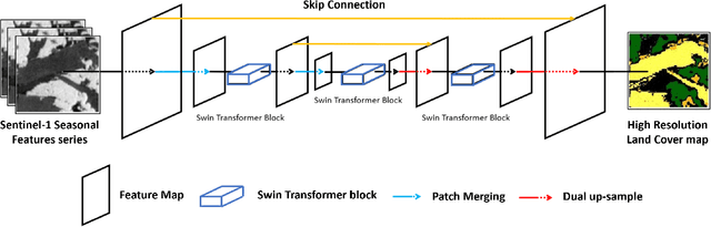
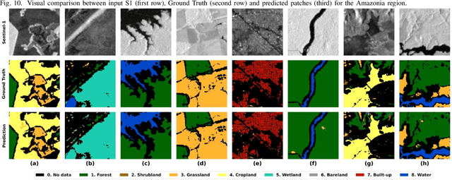
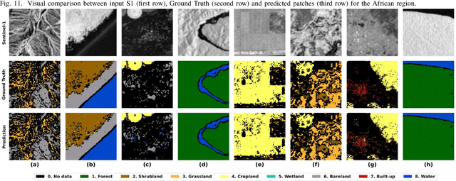
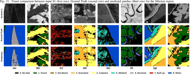
Land Cover (LC) mapping using satellite imagery is critical for environmental monitoring and management. Deep Learning (DL), particularly Convolutional Neural Networks (CNNs) and Vision Transformers (ViTs), have revolutionized this field by enhancing the accuracy of classification tasks. In this work, a novel approach combining a transformer-based Swin-Unet architecture with seasonal synthesized spatio-temporal images has been employed to classify LC types using spatio-temporal features extracted from Sentinel-1 (S1) Synthetic Aperture Radar (SAR) data, organized into seasonal clusters. The study focuses on three distinct regions - Amazonia, Africa, and Siberia - and evaluates the model performance across diverse ecoregions within these areas. By utilizing seasonal feature sequences instead of dense temporal sequences, notable performance improvements have been achieved, especially in regions with temporal data gaps like Siberia, where S1 data distribution is uneven and non-uniform. The results demonstrate the effectiveness and the generalization capabilities of the proposed methodology in achieving high overall accuracy (O.A.) values, even in regions with limited training data.
Benchmarking of a new data splitting method on volcanic eruption data
Oct 08, 2024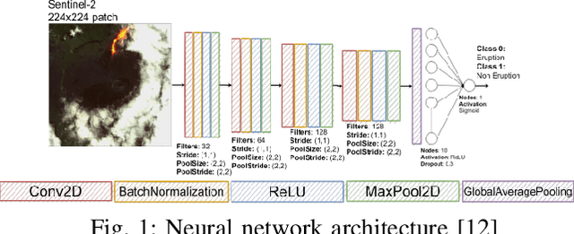
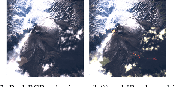
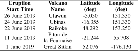

In this paper, a novel method for data splitting is presented: an iterative procedure divides the input dataset of volcanic eruption, chosen as the proposed use case, into two parts using a dissimilarity index calculated on the cumulative histograms of these two parts. The Cumulative Histogram Dissimilarity (CHD) index is introduced as part of the design. Based on the obtained results the proposed model in this case, compared to both Random splitting and K-means implemented over different configurations, achieves the best performance, with a slightly higher number of epochs. However, this demonstrates that the model can learn more deeply from the input dataset, which is attributable to the quality of the splitting. In fact, each model was trained with early stopping, suitable in case of overfitting, and the higher number of epochs in the proposed method demonstrates that early stopping did not detect overfitting, and consequently, the learning was optimal.
SEN12-WATER: A New Dataset for Hydrological Applications and its Benchmarking
Sep 25, 2024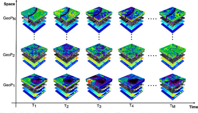

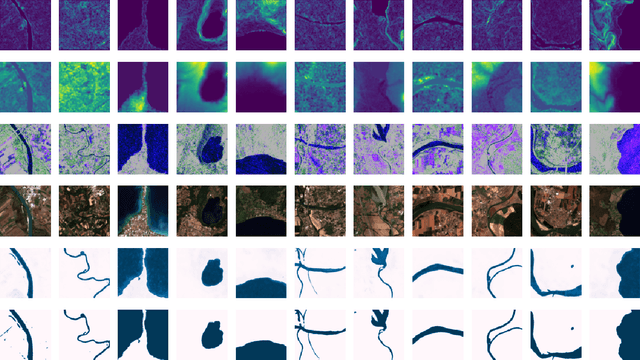

Climate change and increasing droughts pose significant challenges to water resource management around the world. These problems lead to severe water shortages that threaten ecosystems, agriculture, and human communities. To advance the fight against these challenges, we present a new dataset, SEN12-WATER, along with a benchmark using a novel end-to-end Deep Learning (DL) framework for proactive drought-related analysis. The dataset, identified as a spatiotemporal datacube, integrates SAR polarization, elevation, slope, and multispectral optical bands. Our DL framework enables the analysis and estimation of water losses over time in reservoirs of interest, revealing significant insights into water dynamics for drought analysis by examining temporal changes in physical quantities such as water volume. Our methodology takes advantage of the multitemporal and multimodal characteristics of the proposed dataset, enabling robust generalization and advancing understanding of drought, contributing to climate change resilience and sustainable water resource management. The proposed framework involves, among the several components, speckle noise removal from SAR data, a water body segmentation through a U-Net architecture, the time series analysis, and the predictive capability of a Time-Distributed-Convolutional Neural Network (TD-CNN). Results are validated through ground truth data acquired on-ground via dedicated sensors and (tailored) metrics, such as Precision, Recall, Intersection over Union, Mean Squared Error, Structural Similarity Index Measure and Peak Signal-to-Noise Ratio.
From Graphs to Qubits: A Critical Review of Quantum Graph Neural Networks
Aug 12, 2024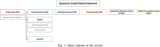
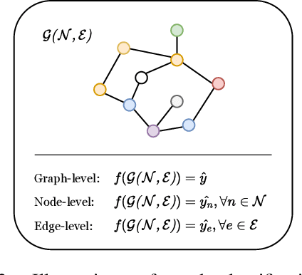
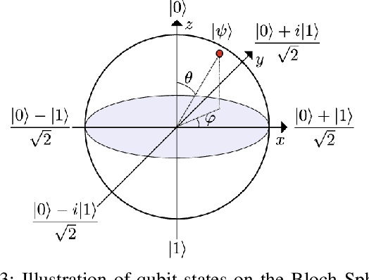

Quantum Graph Neural Networks (QGNNs) represent a novel fusion of quantum computing and Graph Neural Networks (GNNs), aimed at overcoming the computational and scalability challenges inherent in classical GNNs that are powerful tools for analyzing data with complex relational structures but suffer from limitations such as high computational complexity and over-smoothing in large-scale applications. Quantum computing, leveraging principles like superposition and entanglement, offers a pathway to enhanced computational capabilities. This paper critically reviews the state-of-the-art in QGNNs, exploring various architectures. We discuss their applications across diverse fields such as high-energy physics, molecular chemistry, finance and earth sciences, highlighting the potential for quantum advantage. Additionally, we address the significant challenges faced by QGNNs, including noise, decoherence, and scalability issues, proposing potential strategies to mitigate these problems. This comprehensive review aims to provide a foundational understanding of QGNNs, fostering further research and development in this promising interdisciplinary field.
Quanv4EO: Empowering Earth Observation by means of Quanvolutional Neural Networks
Jul 24, 2024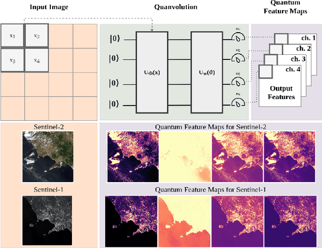
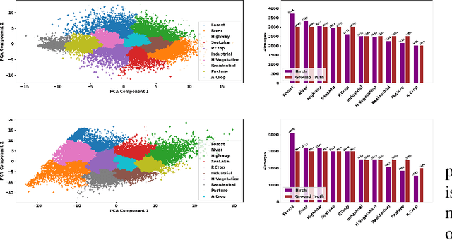
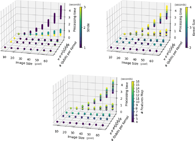
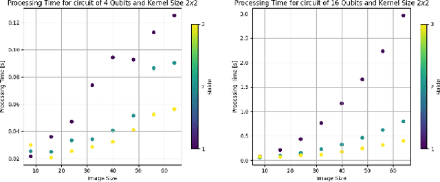
A significant amount of remotely sensed data is generated daily by many Earth observation (EO) spaceborne and airborne sensors over different countries of our planet. Different applications use those data, such as natural hazard monitoring, global climate change, urban planning, and more. Many challenges are brought by the use of these big data in the context of remote sensing applications. In recent years, employment of machine learning (ML) and deep learning (DL)-based algorithms have allowed a more efficient use of these data but the issues in managing, processing, and efficiently exploiting them have even increased since classical computers have reached their limits. This article highlights a significant shift towards leveraging quantum computing techniques in processing large volumes of remote sensing data. The proposed Quanv4EO model introduces a quanvolution method for preprocessing multi-dimensional EO data. First its effectiveness is demonstrated through image classification tasks on MNIST and Fashion MNIST datasets, and later on, its capabilities on remote sensing image classification and filtering are shown. Key findings suggest that the proposed model not only maintains high precision in image classification but also shows improvements of around 5\% in EO use cases compared to classical approaches. Moreover, the proposed framework stands out for its reduced parameter size and the absence of training quantum kernels, enabling better scalability for processing massive datasets. These advancements underscore the promising potential of quantum computing in addressing the limitations of classical algorithms in remote sensing applications, offering a more efficient and effective alternative for image data classification and analysis.
QSpeckleFilter: a Quantum Machine Learning approach for SAR speckle filtering
Feb 02, 2024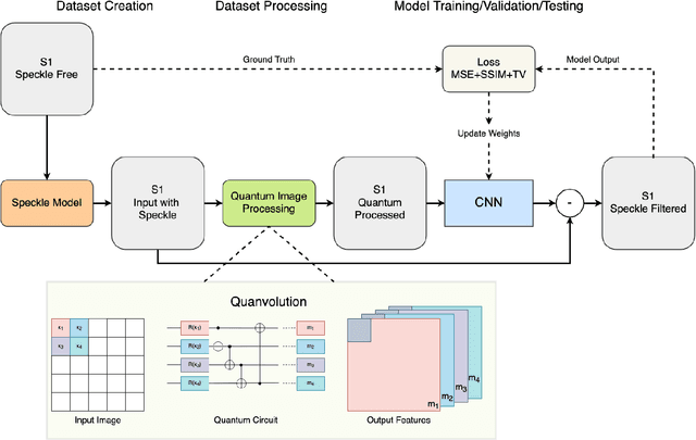
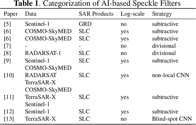
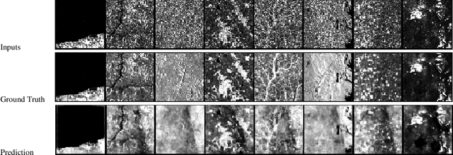
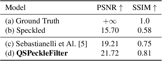
The use of Synthetic Aperture Radar (SAR) has greatly advanced our capacity for comprehensive Earth monitoring, providing detailed insights into terrestrial surface use and cover regardless of weather conditions, and at any time of day or night. However, SAR imagery quality is often compromised by speckle, a granular disturbance that poses challenges in producing accurate results without suitable data processing. In this context, the present paper explores the cutting-edge application of Quantum Machine Learning (QML) in speckle filtering, harnessing quantum algorithms to address computational complexities. We introduce here QSpeckleFilter, a novel QML model for SAR speckle filtering. The proposed method compared to a previous work from the same authors showcases its superior performance in terms of Peak Signal-to-Noise Ratio (PSNR) and Structural Similarity Index Measure (SSIM) on a testing dataset, and it opens new avenues for Earth Observation (EO) applications.
A Hybrid MLP-Quantum approach in Graph Convolutional Neural Networks for Oceanic Nino Index prediction
Jan 29, 2024This paper explores an innovative fusion of Quantum Computing (QC) and Artificial Intelligence (AI) through the development of a Hybrid Quantum Graph Convolutional Neural Network (HQGCNN), combining a Graph Convolutional Neural Network (GCNN) with a Quantum Multilayer Perceptron (MLP). The study highlights the potentialities of GCNNs in handling global-scale dependencies and proposes the HQGCNN for predicting complex phenomena such as the Oceanic Nino Index (ONI). Preliminary results suggest the model potential to surpass state-of-the-art (SOTA). The code will be made available with the paper publication.