 Add to Chrome
 Add to Firefox
 Add to Edge
Ttpla
Papers and Code
Power Line Aerial Image Restoration under dverse Weather: Datasets and Baselines
Sep 07, 2024


Power Line Autonomous Inspection (PLAI) plays a crucial role in the construction of smart grids due to its great advantages of low cost, high efficiency, and safe operation. PLAI is completed by accurately detecting the electrical components and defects in the aerial images captured by Unmanned Aerial Vehicles (UAVs). However, the visible quality of aerial images is inevitably degraded by adverse weather like haze, rain, or snow, which are found to drastically decrease the detection accuracy in our research. To circumvent this problem, we propose a new task of Power Line Aerial Image Restoration under Adverse Weather (PLAIR-AW), which aims to recover clean and high-quality images from degraded images with bad weather thus improving detection performance for PLAI. In this context, we are the first to release numerous corresponding datasets, namely, HazeCPLID, HazeTTPLA, HazeInsPLAD for power line aerial image dehazing, RainCPLID, RainTTPLA, RainInsPLAD for power line aerial image deraining, SnowCPLID, SnowInsPLAD for power line aerial image desnowing, which are synthesized upon the public power line aerial image datasets of CPLID, TTPLA, InsPLAD following the mathematical models. Meanwhile, we select numerous state-of-the-art methods from image restoration community as the baseline methods for PLAIR-AW. At last, we conduct large-scale empirical experiments to evaluate the performance of baseline methods on the proposed datasets. The proposed datasets and trained models are available at https://github.com/ntuhubin/PLAIR-AW.
DUFormer: A Novel Architecture for Power Line Segmentation of Aerial Images
Apr 12, 2023Power lines pose a significant safety threat to unmanned aerial vehicles (UAVs) operating at low altitudes. However, detecting power lines in aerial images is challenging due to the small size of the foreground data (i.e., power lines) and the abundance of background information. To address this challenge, we propose DUFormer, a semantic segmentation algorithm designed specifically for power line detection in aerial images. We assume that performing sufficient feature extraction with a convolutional neural network (CNN) that has a strong inductive bias is beneficial for training an efficient Transformer model. To this end, we propose a heavy token encoder responsible for overlapping feature re-mining and tokenization. The encoder comprises a pyramid CNN feature extraction module and a power line feature enhancement module. Following sufficient feature extraction for power lines, the feature fusion is carried out, and then the Transformer block is used for global modeling. The final segmentation result is obtained by fusing local and global features in the decode head. Additionally, we demonstrate the significance of the joint multi-weight loss function in power line segmentation. The experimental results demonstrate that our proposed method achieves the state-of-the-art performance in power line segmentation on the publicly available TTPLA dataset.
PL-UNeXt: Per-stage Edge Detail and Line Feature Guided Segmentation for Power Line Detection
Mar 08, 2023


Power line detection is a critical inspection task for electricity companies and is also useful in avoiding drone obstacles. Accurately separating power lines from the surrounding area in the aerial image is still challenging due to the intricate background and low pixel ratio. In order to properly capture the guidance of the spatial edge detail prior and line features, we offer PL-UNeXt, a power line segmentation model with a booster training strategy. We design edge detail heads computing the loss in edge space to guide the lower-level detail learning and line feature heads generating auxiliary segmentation masks to supervise higher-level line feature learning. Benefited from this design, our model can reach 70.6 F1 score (+1.9%) on TTPLA and 68.41 mIoU (+5.2%) on VITL (without utilizing IR images), while preserving a real-time performance due to few inference parameters.
TTPLA: An Aerial-Image Dataset for Detection and Segmentation of Transmission Towers and Power Lines
Oct 20, 2020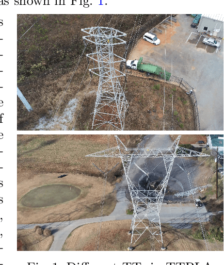
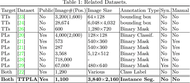
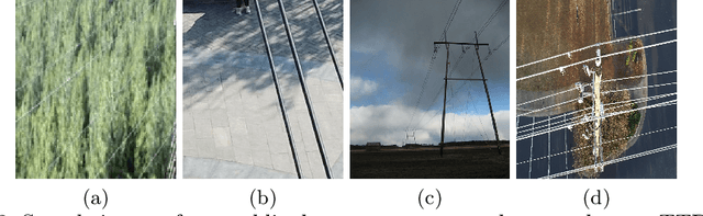
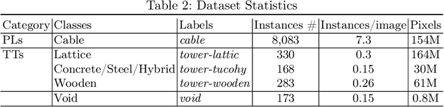
Accurate detection and segmentation of transmission towers~(TTs) and power lines~(PLs) from aerial images plays a key role in protecting power-grid security and low-altitude UAV safety. Meanwhile, aerial images of TTs and PLs pose a number of new challenges to the computer vision researchers who work on object detection and segmentation -- PLs are long and thin, and may show similar color as the background; TTs can be of various shapes and most likely made up of line structures of various sparsity; The background scene, lighting, and object sizes can vary significantly from one image to another. In this paper we collect and release a new TT/PL Aerial-image (TTPLA) dataset, consisting of 1,100 images with the resolution of 3,840$\times$2,160 pixels, as well as manually labeled 8,987 instances of TTs and PLs. We develop novel policies for collecting, annotating, and labeling the images in TTPLA. Different from other relevant datasets, TTPLA supports evaluation of instance segmentation, besides detection and semantic segmentation. To build a baseline for detection and segmentation tasks on TTPLA, we report the performance of several state-of-the-art deep learning models on our dataset. TTPLA dataset is publicly available at https://github.com/r3ab/ttpla_dataset