 Add to Chrome
 Add to Firefox
 Add to Edge
PointQ-Bench: Benchmarking Diagnostic and Interpretable Point Cloud Quality Assessment
May 27, 2026Point cloud quality plays a critical role in 3D acquisition, reconstruction, rendering, and perception, yet existing point cloud quality assessment (PCQA) research remains largely centered on scalar score prediction. In practical inspection scenarios, quality assessment often involves identifying defects, characterizing dominant issue types, assessing downstream usability, and providing evidence-supported descriptions, which are not explicitly evaluated by current benchmarks. We introduce PointQ-Bench, a benchmark designed to extend PCQA from scalar scoring toward comprehensive quality understanding. PointQ-Bench consists of 3,083 point clouds spanning authentic scans, simulated distortions, and AI-generated content, covering eight major issue types. Each sample is annotated with mean opinion scores (MOS), quality levels, issue tags, expert-grounded descriptions, and 12,332 question-answer pairs. The benchmark supports three perception-oriented tasks: anomaly sensing, defect diagnosis, and usability grading, as well as a cognition-oriented task of open-ended quality reporting. To evaluate free-form quality descriptions, we further propose SSFRQ-5D, a five-dimensional evaluation protocol validated through human-AI agreement analysis. Extensive experiments on 14 vision-language models and traditional PCQA baselines reveal a consistent perception-diagnosis gap: while current models exhibit emerging abilities in coarse defect perception, they struggle with grounded diagnosis and quality calibration. Strong 2D MLLMs generally outperform existing 3D VLMs, and the benefit of additional views or point-level inputs is non-uniform, varying across tasks, data sources, and models, particularly under boundary-ambiguous conditions. Overall, PointQ-Bench provides a diagnostic testbed for advancing reliable and interpretable point cloud quality understanding.
ForestHG-Trace: Traceable Long-Horizon Ecological Reasoning over Large-Scale Forest Scenes
May 26, 2026Remote sensing question answering (RS-QA) often requires more than direct semantic prediction, especially in large-scale forest scenes where ecological analysis involves multi-step filtering, numerical aggregation, neighborhood reasoning, and verifiable evidence. We introduce ForestHG-Trace, a framework for traceable long-horizon ecological reasoning over forest environments. It represents multimodal NEON forest scenes as ecological hypergraphs, where tree instances, spatial units, semantic groups, and neighborhood relations support higher-order reasoning beyond pairwise scene graphs. An LLM-guided agent then invokes deterministic tools for reading, filtering, expansion, aggregation, comparison, and auditing, producing replayable execution traces and compact evidence records rather than only free-form answers. We further construct ForestTraceQA, an executable benchmark for evaluating ecological QA across diverse task types and reasoning depths. Experiments show that ForestHG-Trace substantially improves answer accuracy and execution faithfulness over single-step baselines and scene-graph agents, while highlighting execution depth as the main bottleneck for long-horizon ecological QA.
VertiCue-Bench: Diagnosing Whether MLLMs Use Height Cues to Resolve 2D Ambiguity in Remote Sensing Natural Scenes
May 25, 2026Multimodal Large Language Models (MLLMs) have recently shown promising progress in geospatial reasoning. However, existing remote sensing benchmarks remain largely 2D-centric, evaluating models primarily on optical appearance. In natural environments, this paradigm breaks down due to severe spectral confusion, where ecologically distinct regions share similar textures but differ fundamentally in vertical structure. In such cases, explicit 3D structural data, such as Canopy Height Models (CHMs), become essential geometric evidence for semantic disambiguation. Yet, it remains unclear whether current MLLMs can genuinely leverage vertical cues to resolve appearance-level ambiguity. To address this gap, we introduce VertiCue-Bench, the first diagnostic benchmark for CHM-grounded geospatial reasoning. VertiCue-Bench comprises 1,534 carefully curated instances across 17 tasks, explicitly disentangling low-level height perception from ambiguity-aware semantic reasoning. Evaluations on 14 state-of-the-art general and remote-sensing-specialized MLLMs, combined with counterfactual modality testing, reveal a striking perception-reasoning dissociation. While models exhibit emerging competence in reading raw CHM height cues, they largely fail to translate geometric perception into reliable semantic reasoning, often underperforming RGB-only baselines when joint constraints are required. Overall, VertiCue-Bench exposes a critical geometry-to-semantics gap in natural scene understanding, offering actionable insights for advancing geospatial MLLMs.
Cell-free massive MIMO Channels in an Urban Environment -- Measurements and Channel Statistics
Jun 03, 2024


Cell-free massive MIMO (CF-mMIMO), where each user equipment (UE) is connected to multiple access points (APs), is emerging as an important component for 5G and 6G cellular systems. Accurate channel models based on measurements are required to optimize their design and deployment. This paper presents an extensive measurement campaign for CF-mMIMO in an urban environment. A new "virtual AP" technique measures channels between 80 UE locations and more than 20,000 possible microcellular AP locations. Measurements are done at 3.5 GHz carrier frequency with 350 MHz bandwidth (BW). The paper describes the measurement setup and data processing, shows sample results and their physical interpretation, and provides statistics for key quantities such as pathloss, shadowing, delay spread (DS), and delay window. We find pathloss coefficients of 2.9 and 10.4 for line-of-sight (LOS) and non line-of-sight (NLOS), respectively, where the high LOS coefficient is mainly because larger distance leads to more grazing angle of incidence and thus lower antenna gain in our setup. Shadowing standard deviations are 5.1/16.6 dB, and root mean squared (RMS) DSs of -80.6/-72.6 dBs. The measurements can also be used for parameterizing a CUNEC-type model, which will be reported in future work.
Large-scale Outdoor Cell-free mMIMO Channel Measurement in an Urban Scenario at 3.5 GHz
May 31, 2024


The design of cell-free massive MIMO (CF-mMIMO) systems requires accurate, measurement-based channel models. This paper provides the first results from the by far most extensive outdoor measurement campaign for CF-mMIMO channels in an urban environment. We measured impulse responses between over 20,000 potential access point (AP) locations and 80 user equipments (UEs) at 3.5 GHz with 350 MHz bandwidth (BW). Measurements use a "virtual array" approach at the AP and a hybrid switched/virtual approach at the UE. This paper describes the sounder design, measurement environment, data processing, and sample results, particularly the evolution of the power-delay profiles (PDPs) as a function of the AP locations, and its relation to the propagation environment.
A Framework for Developing and Evaluating Algorithms for Estimating Multipath Propagation Parameters from Channel Sounder Measurements
Oct 12, 2023


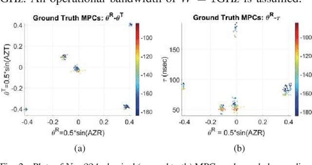
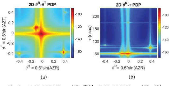
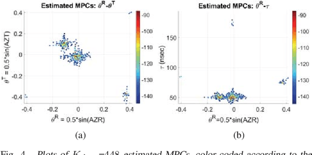
A framework is proposed for developing and evaluating algorithms for extracting multipath propagation components (MPCs) from measurements collected by channel sounders at millimeter-wave frequencies. Sounders equipped with an omnidirectional transmitter and a receiver with a uniform planar array (UPA) are considered. An accurate mathematical model is developed for the spatial frequency response of the sounder that incorporates the non-ideal cross-polar beampatterns for the UPA elements. Due to the limited Field-of-View (FoV) of each element, the model is extended to accommodate multi-FoV measurements in distinct azimuth directions. A beamspace representation of the spatial frequency response is leveraged to develop three progressively complex algorithms aimed at solving the singlesnapshot maximum likelihood estimation problem: greedy matching pursuit (CLEAN), space-alternative generalized expectationmaximization (SAGE), and RiMAX. The first two are based on purely specular MPCs whereas RiMAX also accommodates diffuse MPCs. Two approaches for performance evaluation are proposed, one with knowledge of ground truth parameters, and one based on reconstruction mean-squared error. The three algorithms are compared through a demanding channel model with hundreds of MPCs and through real measurements. The results demonstrate that CLEAN gives quite reasonable estimates which are improved by SAGE and RiMAX. Lessons learned and directions for future research are discussed.
A Framework for Developing Algorithms for Estimating Propagation Parameters from Measurements
Sep 13, 2021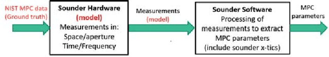
A framework is proposed for developing and evaluating algorithms for extracting multipath propagation components (MPCs) from measurements collected by sounders at millimeter-wave (mmW) frequencies. To focus on algorithmic performance, an idealized model is proposed for the spatial frequency response of the propagation environment measured by a sounder. The input to the sounder model is a pre-determined set of MPC parameters that serve as the "ground truth." A three-dimensional angle-delay (beamspace) representation of the measured spatial frequency response serves as a natural domain for implementing and analyzing MPC extraction algorithms. Metrics for quantifying the error in estimated MPC parameters are introduced. Initial results are presented for a greedy matching pursuit algorithm that performs a least-squares (LS) reconstruction of the MPC path gains within the iterations. The results indicate that the simple greedy-LS algorithm has the ability to extract MPCs over a large dynamic range, and suggest several avenues for further performance improvement through extensions of the greedy-LS algorithm as well as by incorporating features of other algorithms, such as SAGE and RIMAX.