 Add to Chrome
 Add to Firefox
 Add to Edge
RTSKG: Building a Rail Transit Station Knowledge Graph Dataset
Aug 11, 2026
Rail transit systems play a vital role in urban mobility and economic development. As key components of such systems, rail transit stations function as critical transport hubs that enhance urban accessibility and stimulate development in surrounding areas. City-level rail transit station related tasks (e.g., ridership prediction) require large-scale urban data, but current studies often neglect complex interactions among various urban entities in terms of data organization. In this paper, to address the above issue, we build a Rail Transit Station Knowledge Graph (RTSKG) dataset which explicitly models the spatial and semantic interactions among different kinds of urban entities, to benefit city-level rail transit station related tasks. RTSKG integrates heterogeneous urban entities, such as rail transit stations, road segments, and points of interest, with a specially designed unified schema, and is accessible as Linked Data at https://w3id.org/rtskg/. Evaluations on station-area store recommendation and knowledge-enhanced ridership prediction demonstrate the effectiveness of RTSKG, highlighting its potential to support city-level rail transit station analysis.

A Cost-Effective Multimodal LLM Reasoning Framework for Question Answering over Irregular Clinical Time Series
Jul 28, 2026Question answering (QA) over irregular clinical time series (ICTS) plays a pivotal role in a wide range of healthcare applications. Although recent multimodal time-series large language models (LLMs) have shown considerable promise in general-purpose time-series QA, they remain poorly equipped to model the sparsity, asynchrony, and irregular sampling patterns of clinical observations. To fill this gap, we propose ClinPRISM, a cost-effective multimodal LLM reasoning framework for question answering over ICTS data. First, we devise an irregularity-aware multi-scale encoder to capture sparse clinical evidence at diverse temporal scales. Then, we propose a temporal evidence distiller to integrate representations across these scales and compress them into a small number of LLM-compatible tokens. Moreover, we introduce a progressive alignment strategy that sequentially aligns the irregular trajectories with the LLM's textual embedding space. To facilitate training, we construct 30,000 clinical time series paired with multi-scale descriptions, together with 41,000 instruction-tuning instances spanning 11 tasks. Using a 4-billion-parameter LLM backbone, ClinPRISM achieves state-of-the-art performance on the held-out evaluation benchmark while using only 16 time-series tokens and achieving an average inference latency of 0.15 seconds per question.
ClinLens: Towards Long-Horizon Coding Agents for Longitudinal Multimodal Clinical Data Science
Jul 28, 2026Clinical data-science agents must transform heterogeneous longitudinal records into auditable analyses, yet existing benchmarks largely isolate medical question answering, structured-table reasoning, or generic scientific repositories. We introduce CLINLENS, a benchmark of 200 executable tasks over five linked MIMIC resources spanning structured electronic health records, notes, electrocardiograms, chest radiographs, and echocardiograms. A 4 x 5 taxonomy crosses four patient-time scopes with five analysis capabilities. Program-first reverse synthesis pairs each bounded semi-raw package with an evaluator-private reference workflow and checks required artifacts, cohort and temporal semantics, and the final answer. On a fixed 126-task suite, the strongest of 24 standardized model-scaffold configurations achieves 56.3% scope-macro STRICTPASS despite 100% EXECSUCCESS. For reference, a separately configured coding agent solves 83 of 126 tasks, while five biomedical systems adapted to GPT-4o-mini reach at most 2.9% scope-macro STRICTPASS. These results expose a substantial gap between runnable submissions and correct clinical analyses.
CLIR-Bench: Benchmarking Multimodal Question Answering over Irregular Clinical Time Series
Jul 10, 2026Clinical time series are central to patient monitoring, risk assessment, and clinical decision support. However, they are often sparse, irregularly sampled, and asynchronous, making it difficult for models to identify the temporal evidence required for clinical Question Answering (QA). Existing benchmarks primarily focus on regularly sampled time-series QA or medical QA over static data, and therefore rarely assess whether models can faithfully ground their answers in irregular temporal observations. To fill this gap, we introduce CLIR-Bench, a benchmark for irregular clinical time series QA constructed from de-identified ICU records through a principled four-stage pipeline. CLIR-Bench contains 6,600 QA instances spanning 11 clinical variables, organized into four capability dimensions and 11 tasks. Each question is linked to explicit temporal evidence and task-specific answer derivation rules, enabling evaluation of both answer accuracy and evidence use. Experiments show that existing generalist models struggle to retrieve and reason over sparse clinical evidence, highlighting the need for stronger irregular time-series reasoning methods. Our code and data are available at https://huggingface.co/datasets/winall/CLIR-Bench.
MR-LiDAR: A Multi-Resolution Roadside LiDAR Benchmark for Perception Diagnostics and Deployment Guidance
May 23, 2026LiDAR model selection is a critical issue in roadside sensing systems, as it directly determines both perception capability and deployment cost. However, the lack of empirical benchmarks for comparing perception performance across different LiDAR configurations has greatly constrained scientific sensor selection and deployment planning. To address this gap, we present MR-LiDAR, a controlled multi-resolution LiDAR benchmark for roadside perception diagnostics. Using 16-, 32-, 80-, and 128-beam LiDARs in identical roadside scenarios, we collect point clouds and ground-truth annotations for diverse traffic participants, including vehicles and vulnerable road users (VRUs), across varying distances. This controlled design isolates intrinsic LiDAR specifications, particularly beam count and beam distribution, as the key variables for precise performance diagnostics. Based on MR-LiDAR, we conduct systematic empirical analyses to examine how beam count, beam distribution, target distance, object category, and vehicle occlusion affect LiDAR perception performance. The results reveal that all of these factors have substantial impacts. In particular, contrary to the common assumption that higher beam counts always yield better perception, we show that an 80-beam LiDAR with optimized beam distribution can match or even outperform a 128-beam LiDAR with uniform beam distribution. In addition, we provide a practical reference guide for LiDAR selection, including target point-count statistics and detection performance comparisons based on two widely used detection algorithms. This work offers a diagnostic benchmark and practical guidance for determining cost-effective LiDAR configurations in roadside perception applications.
Watch Your Step: Learning Semantically-Guided Locomotion in Cluttered Environment
Mar 03, 2026Although legged robots demonstrate impressive mobility on rough terrain, using them safely in cluttered environments remains a challenge. A key issue is their inability to avoid stepping on low-lying objects, such as high-cost small devices or cables on flat ground. This limitation arises from a disconnection between high-level semantic understanding and low-level control, combined with errors in elevation maps during real-world operation. To address this, we introduce SemLoco, a Reinforcement Learning (RL) framework designed to avoid obstacles precisely in densely cluttered environments. SemLoco uses a two-stage RL approach that combines both soft and hard constraints and performs pixel-wise foothold safety inference, enabling more accurate foot placement. Additionally, SemLoco integrates a semantic map to assign traversability costs rather than relying solely on geometric data. SemLoco significantly reduces collisions and improves safety around sensitive objects, enabling reliable navigation in situations where traditional controllers would likely cause damage. Experimental results further demonstrate that SemLoco can be effectively applied to more complex, unstructured real-world environments.
MSCMHMST: A traffic flow prediction model based on Transformer
Mar 16, 2025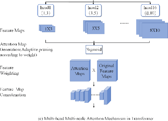
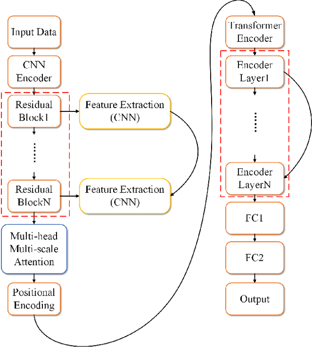
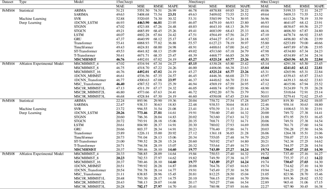
This study proposes a hybrid model based on Transformers, named MSCMHMST, aimed at addressing key challenges in traffic flow prediction. Traditional single-method approaches show limitations in traffic prediction tasks, whereas hybrid methods, by integrating the strengths of different models, can provide more accurate and robust predictions. The MSCMHMST model introduces a multi-head, multi-scale attention mechanism, allowing the model to parallel process different parts of the data and learn its intrinsic representations from multiple perspectives, thereby enhancing the model's ability to handle complex situations. This mechanism enables the model to capture features at various scales effectively, understanding both short-term changes and long-term trends. Verified through experiments on the PeMS04/08 dataset with specific experimental settings, the MSCMHMST model demonstrated excellent robustness and accuracy in long, medium, and short-term traffic flow predictions. The results indicate that this model has significant potential, offering a new and effective solution for the field of traffic flow prediction.
Drone Data Analytics for Measuring Traffic Metrics at Intersections in High-Density Areas
Nov 04, 2024This study employed over 100 hours of high-altitude drone video data from eight intersections in Hohhot to generate a unique and extensive dataset encompassing high-density urban road intersections in China. This research has enhanced the YOLOUAV model to enable precise target recognition on unmanned aerial vehicle (UAV) datasets. An automated calibration algorithm is presented to create a functional dataset in high-density traffic flows, which saves human and material resources. This algorithm can capture up to 200 vehicles per frame while accurately tracking over 1 million road users, including cars, buses, and trucks. Moreover, the dataset has recorded over 50,000 complete lane changes. It is the largest publicly available road user trajectories in high-density urban intersections. Furthermore, this paper updates speed and acceleration algorithms based on UAV elevation and implements a UAV offset correction algorithm. A case study demonstrates the usefulness of the proposed methods, showing essential parameters to evaluate intersections and traffic conditions in traffic engineering. The model can track more than 200 vehicles of different types simultaneously in highly dense traffic on an urban intersection in Hohhot, generating heatmaps based on spatial-temporal traffic flow data and locating traffic conflicts by conducting lane change analysis and surrogate measures. With the diverse data and high accuracy of results, this study aims to advance research and development of UAVs in transportation significantly. The High-Density Intersection Dataset is available for download at https://github.com/Qpu523/High-density-Intersection-Dataset.
Real-Time Vehicle Detection and Urban Traffic Behavior Analysis Based on UAV Traffic Videos on Mobile Devices
Feb 26, 2024This paper focuses on a real-time vehicle detection and urban traffic behavior analysis system based on Unmanned Aerial Vehicle (UAV) traffic video. By using UAV to collect traffic data and combining the YOLOv8 model and SORT tracking algorithm, the object detection and tracking functions are implemented on the iOS mobile platform. For the problem of traffic data acquisition and analysis, the dynamic computing method is used to process the performance in real time and calculate the micro and macro traffic parameters of the vehicles, and real-time traffic behavior analysis is conducted and visualized. The experiment results reveals that the vehicle object detection can reach 98.27% precision rate and 87.93% recall rate, and the real-time processing capacity is stable at 30 frames per seconds. This work integrates drone technology, iOS development, and deep learning techniques to integrate traffic video acquisition, object detection, object tracking, and traffic behavior analysis functions on mobile devices. It provides new possibilities for lightweight traffic information collection and data analysis, and offers innovative solutions to improve the efficiency of analyzing road traffic conditions and addressing transportation issues for transportation authorities.
Deep Q-Network Based Decision Making for Autonomous Driving
Mar 21, 2023Currently decision making is one of the biggest challenges in autonomous driving. This paper introduces a method for safely navigating an autonomous vehicle in highway scenarios by combining deep Q-Networks and insight from control theory. A Deep Q-Network is trained in simulation to serve as a central decision-making unit by proposing targets for a trajectory planner. The generated trajectories in combination with a controller for longitudinal movement are used to execute lane change maneuvers. In order to prove the functionality of this approach it is evaluated on two different highway traffic scenarios. Furthermore, the impact of different state representations on the performance and training process is analyzed. The results show that the proposed system can produce efficient and safe driving behavior.