 Add to Chrome
 Add to Firefox
 Add to Edge
Searth Transformer: A Transformer Architecture Incorporating Earth's Geospheric Physical Priors for Global Mid-Range Weather Forecasting
Jan 14, 2026Accurate global medium-range weather forecasting is fundamental to Earth system science. Most existing Transformer-based forecasting models adopt vision-centric architectures that neglect the Earth's spherical geometry and zonal periodicity. In addition, conventional autoregressive training is computationally expensive and limits forecast horizons due to error accumulation. To address these challenges, we propose the Shifted Earth Transformer (Searth Transformer), a physics-informed architecture that incorporates zonal periodicity and meridional boundaries into window-based self-attention for physically consistent global information exchange. We further introduce a Relay Autoregressive (RAR) fine-tuning strategy that enables learning long-range atmospheric evolution under constrained memory and computational budgets. Based on these methods, we develop YanTian, a global medium-range weather forecasting model. YanTian achieves higher accuracy than the high-resolution forecast of the European Centre for Medium-Range Weather Forecasts and performs competitively with state-of-the-art AI models at one-degree resolution, while requiring roughly 200 times lower computational cost than standard autoregressive fine-tuning. Furthermore, YanTian attains a longer skillful forecast lead time for Z500 (10.3 days) than HRES (9 days). Beyond weather forecasting, this work establishes a robust algorithmic foundation for predictive modeling of complex global-scale geophysical circulation systems, offering new pathways for Earth system science.
YanTian: An Application Platform for AI Global Weather Forecasting Models
Oct 06, 2024


To promote the practical application of AI Global Weather Forecasting Models (AIGWFM), we have developed an adaptable application platform named 'YanTian'. This platform enhances existing open-source AIGWFM with a suite of capability-enhancing modules and is constructed by a "loosely coupled" plug-in architecture. The goal of 'YanTian' is to address the limitations of current open-source AIGWFM in operational application, including improving local forecast accuracy, providing spatial high-resolution forecasts, increasing density of forecast intervals, and generating diverse products with the provision of AIGC capabilities. 'YianTian' also provides a simple, visualized user interface, allowing meteorologists easily access both basic and extended capabilities of the platform by simply configuring the platform UI. Users do not need to possess the complex artificial intelligence knowledge and the coding techniques. Additionally, 'YianTian' can be deployed on a PC with GPUs. We hope 'YianTian' can facilitate the operational widespread adoption of AIGWFMs.
The Compatibility between the Pangu Weather Forecasting Model and Meteorological Operational Data
Aug 07, 2023


Recently, multiple data-driven models based on machine learning for weather forecasting have emerged. These models are highly competitive in terms of accuracy compared to traditional numerical weather prediction (NWP) systems. In particular, the Pangu-Weather model, which is open source for non-commercial use, has been validated for its forecasting performance by the European Centre for Medium-Range Weather Forecasts (ECMWF) and has recently been published in the journal "Nature". In this paper, we evaluate the compatibility of the Pangu-Weather model with several commonly used NWP operational analyses through case studies. The results indicate that the Pangu-Weather model is compatible with different operational analyses from various NWP systems as the model initial conditions, and it exhibits a relatively stable forecasting capability. Furthermore, we have verified that improving the quality of global or local initial conditions significantly contributes to enhancing the forecasting performance of the Pangu-Weather model.
Meteorological Satellite Images Prediction Based on Deep Multi-scales Extrapolation Fusion
Sep 19, 2022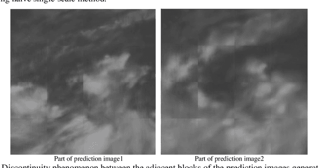
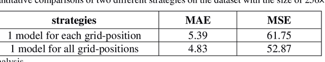
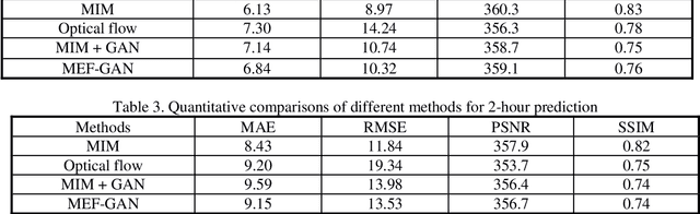
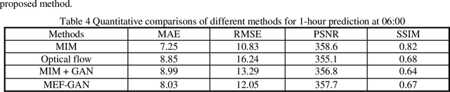
Meteorological satellite imagery is critical for meteorologists. The data have played an important role in monitoring and analyzing weather and climate changes. However, satellite imagery is a kind of observation data and exists a significant time delay when transmitting the data back to Earth. It is important to make accurate predictions for meteorological satellite images, especially the nowcasting prediction up to 2 hours ahead. In recent years, there has been growing interest in the research of nowcasting prediction applications of weather radar images based on deep learning. Compared to the weather radar images prediction problem, the main challenge for meteorological satellite images prediction is the large-scale observation areas and therefore the large sizes of the observation products. Here we present a deep multi-scales extrapolation fusion method, to address the challenge of the meteorological satellite images nowcasting prediction. First, we downsample the original satellite images dataset with large size to several images datasets with smaller resolutions, then we use a deep spatiotemporal sequences prediction method to generate the multi-scales prediction images with different resolutions separately. Second, we fuse the multi-scales prediction results to the targeting prediction images with the original size by a conditional generative adversarial network. The experiments based on the FY-4A meteorological satellite data show that the proposed method can generate realistic prediction images that effectively capture the evolutions of the weather systems in detail. We believe that the general idea of this work can be potentially applied to other spatiotemporal sequence prediction tasks with a large size.