 Add to Chrome
 Add to Firefox
 Add to Edge
From Noisy Historical Maps to Time-Series Oil Palm Mapping Without Annotation in Malaysia and Indonesia (2020-2024)
Apr 26, 2026Accurate monitoring of oil palm plantations is critical for balancing economic development with environmental conservation in Southeast Asia. However, existing plantation maps often suffer from low spatial resolution and a lack of recent temporal coverage, impeding effective surveillance of rapid land-use changes. In this study, we propose a deep learning framework to generate 10-meter resolution oil palm plantation maps for Indonesia and Malaysia from 2020 to 2024, utilizing Sentinel-2 imagery without requiring new manual annotations. To address the resolution mismatch between coarse 100-meter historical labels and 10-meter imagery, we employ a U-Net architecture optimized with Determinant-based Mutual Information (DMI). This approach effectively mitigates the influence of label noise. We validated our method against 2,058 manually verified points, achieving overall accuracies of 70.64%, 63.53%, and 60.06% for the years 2020, 2022, and 2024, respectively. Our comprehensive analysis reveals that oil palm coverage in the region peaked in 2022 before experiencing a decline in 2024. Furthermore, land cover transition analysis highlights a concerning trajectory of plantation expansion into flooded vegetation areas, despite a general stabilization in rotations with other crop types. These high-resolution maps provide essential data for monitoring sustainability commitments and deforestation dynamics in the region, and the generated datasets are made publicly available at https://doi.org/10.5281/zenodo.17768444.
HM-Bench: A Comprehensive Benchmark for Multimodal Large Language Models in Hyperspectral Remote Sensing
Apr 10, 2026While multimodal large language models (MLLMs) have made significant strides in natural image understanding, their ability to perceive and reason over hyperspectral image (HSI) remains underexplored, which is a vital modality in remote sensing. The high dimensionality and intricate spectral-spatial properties of HSI pose unique challenges for models primarily trained on RGB data.To address this gap, we introduce Hyperspectral Multimodal Benchmark (HM-Bench), the first benchmark designed specifically to evaluate MLLMs in HSI understanding. We curate a large-scale dataset of 19,337 question-answer pairs across 13 task categories, ranging from basic perception to spectral reasoning. Given that existing MLLMs are not equipped to process raw hyperspectral cubes natively, we propose a dual-modality evaluation framework that transforms HSI data into two complementary representations: PCA-based composite images and structured textual reports. This approach facilitates a systematic comparison of different representation for model performance. Extensive evaluations on 18 representative MLLMs reveal significant difficulties in handling complex spatial-spectral reasoning tasks. Furthermore, our results demonstrate that visual inputs generally outperform textual inputs, highlighting the importance of grounding in spectral-spatial evidence for effective HSI understanding. Dataset and appendix can be accessed at https://github.com/HuoRiLi-Yu/HM-Bench.
A Comprehensive Review of Agricultural Parcel and Boundary Delineation from Remote Sensing Images: Recent Progress and Future Perspectives
Aug 20, 2025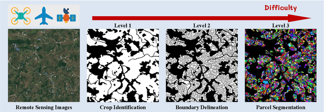
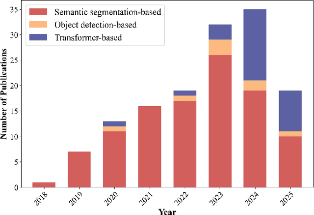
Powered by advances in multiple remote sensing sensors, the production of high spatial resolution images provides great potential to achieve cost-efficient and high-accuracy agricultural inventory and analysis in an automated way. Lots of studies that aim at providing an inventory of the level of each agricultural parcel have generated many methods for Agricultural Parcel and Boundary Delineation (APBD). This review covers APBD methods for detecting and delineating agricultural parcels and systematically reviews the past and present of APBD-related research applied to remote sensing images. With the goal to provide a clear knowledge map of existing APBD efforts, we conduct a comprehensive review of recent APBD papers to build a meta-data analysis, including the algorithm, the study site, the crop type, the sensor type, the evaluation method, etc. We categorize the methods into three classes: (1) traditional image processing methods (including pixel-based, edge-based and region-based); (2) traditional machine learning methods (such as random forest, decision tree); and (3) deep learning-based methods. With deep learning-oriented approaches contributing to a majority, we further discuss deep learning-based methods like semantic segmentation-based, object detection-based and Transformer-based methods. In addition, we discuss five APBD-related issues to further comprehend the APBD domain using remote sensing data, such as multi-sensor data in APBD task, comparisons between single-task learning and multi-task learning in the APBD domain, comparisons among different algorithms and different APBD tasks, etc. Finally, this review proposes some APBD-related applications and a few exciting prospects and potential hot topics in future APBD research. We hope this review help researchers who involved in APBD domain to keep track of its development and tendency.
Can Large Multimodal Models Understand Agricultural Scenes? Benchmarking with AgroMind
May 18, 2025Large Multimodal Models (LMMs) has demonstrated capabilities across various domains, but comprehensive benchmarks for agricultural remote sensing (RS) remain scarce. Existing benchmarks designed for agricultural RS scenarios exhibit notable limitations, primarily in terms of insufficient scene diversity in the dataset and oversimplified task design. To bridge this gap, we introduce AgroMind, a comprehensive agricultural remote sensing benchmark covering four task dimensions: spatial perception, object understanding, scene understanding, and scene reasoning, with a total of 13 task types, ranging from crop identification and health monitoring to environmental analysis. We curate a high-quality evaluation set by integrating eight public datasets and one private farmland plot dataset, containing 25,026 QA pairs and 15,556 images. The pipeline begins with multi-source data preprocessing, including collection, format standardization, and annotation refinement. We then generate a diverse set of agriculturally relevant questions through the systematic definition of tasks. Finally, we employ LMMs for inference, generating responses, and performing detailed examinations. We evaluated 18 open-source LMMs and 3 closed-source models on AgroMind. Experiments reveal significant performance gaps, particularly in spatial reasoning and fine-grained recognition, it is notable that human performance lags behind several leading LMMs. By establishing a standardized evaluation framework for agricultural RS, AgroMind reveals the limitations of LMMs in domain knowledge and highlights critical challenges for future work. Data and code can be accessed at https://rssysu.github.io/AgroMind/.