 Add to Chrome
 Add to Firefox
 Add to Edge
Denial of Deadline: Network-Driven Accuracy Collapse in Distributed Inference Pipelines
Jul 27, 2026
Inference systems increasingly combine a fast path that returns predictions within the application's latency deadline together with a higher-accuracy slow path that runs higher-compute methods on stronger, remote hardware, so its results can be returned on time and combined with the fast path predictions. Across several application domains, we abstract this inference architecture as a fast path, a slow path, and a coordination layer with two functions: a router that invokes the slow path and a merger that decides whether to incorporate its returned predictions. In this work, we show that this new coordination layer exposes a new attack surface: shaped workload attacks, e.g., Yo-Yo bursts, can exploit contention at shared resources along the slow path to push benign users' slow-path predictions past their latency deadlines. The merger then discards those predictions, while the fast path continues to return timely outputs. We refer to the resulting loss of slow-path accuracy benefits as accuracy collapse. We demonstrate accuracy collapse in a two-tier edge-cloud multi-object tracking pipeline in autonomous driving. In simulation, approximately 4,000 burst-shaped requests increase benign p99 latency from 92ms to 2s, nearly eliminating the benefit of the slow path's cloud inference, reducing object tracking quality by 7.0 HOTA points on average. We further find that accuracy degradation can significantly vary (2.0-18.7 HOTA points), depending on the video intervals that are targeted in the attack, and that certain rare classes (e.g., stop signs) lose nearly half of their pre-attack prediction accuracy. These results show that workload attacks can degrade prediction quality without needing either access to model weights or victim data, and motivate research on attacks and defenses for routing, merging, scheduling, and resource isolation in these emerging inference pipeline architectures.

Statistical Model of Time-varying Backscatter Power of Monostatic RF Sensing Channels in Urban Canyons
May 05, 2026We present a measurement-based statistical model for the backscatter power ratio of monostatic RF sensing in urban canyons with moving clutter, suitable for large-scale system level performance evaluation of RF sensing in 6G networks. A narrowband (CW) 140 GHz sounder used a monostatic radar arrangement with an omnidirectional transmit antenna illuminating streets and a spinning horn 2o receive antenna offset vertically (less than 1 m away) collecting backscattered power as a function of azimuth and time below building height in Manhattan and Valparaiso, Chile. A concise outdoor deterministic model of average backscattered power dependent on distance to nearest building-wall reproduces observations with 3.3 dB RMS error or better. Distribution of power variation in azimuth around this average is reproduced within 0.5 dB by a random azimuth spectrum with a lognormal distribution. Temporal fluctuations for various antenna aims and locations were found to be well modeled by a Rician distribution, with lognormally distributed K-factor, with 0.47-0.73 correlation coefficient to backscatter power deviation from mean. The statistical model does not require a detailed environmental description, aiming to reproduce backscatter clutter statistics (as opposed to a deterministic response) faithfully and efficiently, essential for large-scale system-level performance evaluation.
A Vision-Based Analysis of Congestion Pricing in New York City
Feb 03, 2026We examine the impact of New York City's congestion pricing program through automated analysis of traffic camera data. Our computer vision pipeline processes footage from over 900 cameras distributed throughout Manhattan and New York, comparing traffic patterns from November 2024 through the program's implementation in January 2025 until January 2026. We establish baseline traffic patterns and identify systematic changes in vehicle density across the monitored region.
AWaRe-SAC: Proactive Slice Admission Control under Weather-Induced Capacity Uncertainty
Jan 09, 2026As emerging applications demand higher throughput and lower latencies, operators are increasingly deploying millimeter-wave (mmWave) links within x-haul transport networks, spanning fronthaul, midhaul, and backhaul segments. However, the inherent susceptibility of mmWave frequencies to weather-related attenuation, particularly rain fading, complicates the maintenance of stringent Quality of Service (QoS) requirements. This creates a critical challenge: making admission decisions under uncertainty regarding future network capacity. To address this, we develop a proactive slice admission control framework for mmWave x-haul networks subject to rain-induced fluctuations. Our objective is to improve network performance, ensure QoS, and optimize revenue, thereby surpassing the limitations of standard reactive approaches. The proposed framework integrates a deep learning predictor of future network conditions with a proactive Q-learning-based slice admission control mechanism. We validate our solution using real-world data from a mmWave x-haul deployment in a dense urban area, incorporating realistic models of link capacity attenuation and dynamic slice demands. Extensive evaluations demonstrate that our proactive solution achieves 2-3x higher long-term average revenue under dynamic link conditions, providing a scalable and resilient framework for adaptive admission control.
Fair Dynamic Spectrum Access via Fully Decentralized Multi-Agent Reinforcement Learning
Mar 31, 2025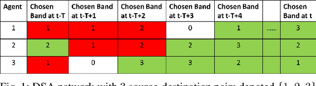
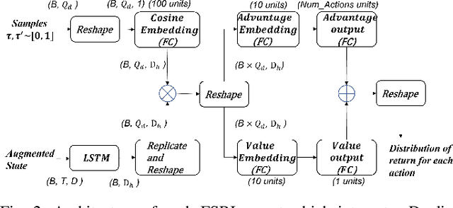
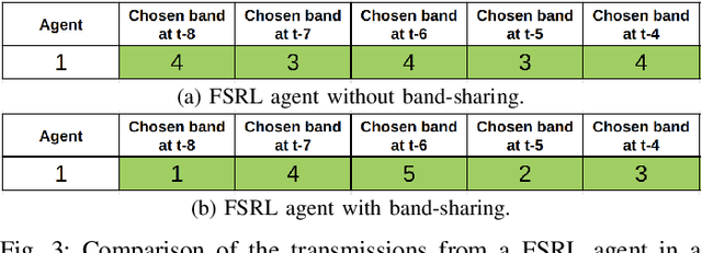
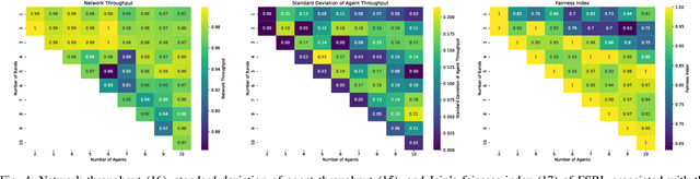
We consider a decentralized wireless network with several source-destination pairs sharing a limited number of orthogonal frequency bands. Sources learn to adapt their transmissions (specifically, their band selection strategy) over time, in a decentralized manner, without sharing information with each other. Sources can only observe the outcome of their own transmissions (i.e., success or collision), having no prior knowledge of the network size or of the transmission strategy of other sources. The goal of each source is to maximize their own throughput while striving for network-wide fairness. We propose a novel fully decentralized Reinforcement Learning (RL)-based solution that achieves fairness without coordination. The proposed Fair Share RL (FSRL) solution combines: (i) state augmentation with a semi-adaptive time reference; (ii) an architecture that leverages risk control and time difference likelihood; and (iii) a fairness-driven reward structure. We evaluate FSRL in more than 50 network settings with different number of agents, different amounts of available spectrum, in the presence of jammers, and in an ad-hoc setting. Simulation results suggest that, when we compare FSRL with a common baseline RL algorithm from the literature, FSRL can be up to 89.0% fairer (as measured by Jain's fairness index) in stringent settings with several sources and a single frequency band, and 48.1% fairer on average.
Channel and Spectrum Consumption Models for Urban Outdoor-to-Outdoor 28 GHz Wireless
Mar 14, 2025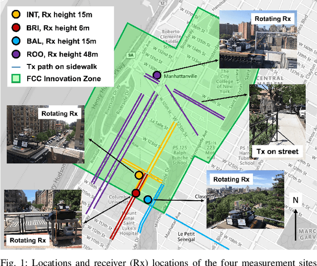
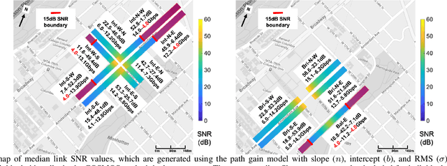
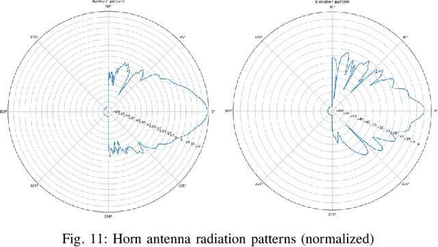
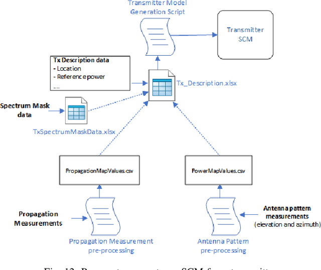
Next generation wireless and mobile networks will utilize millimeter-wave (mmWave) communication to achieve significantly increased data rates. However, since mmWave radio signals experience high path loss, the operation of mmWave networks will require accurate channel models designed for specific deployment sites. In this paper, we focus on the deployment area of the PAWR COSMOS testbed in New York City and report extensive 28 GHz channel measurements. These include over 46 million power measurements collected from over 3,000 links on 24 sidewalks at 4 different sites and in different settings. Using these measurements, we study the effects of the setup and environments (e.g., transmitter height and seasonal effects). We then discuss the obtained path gain values and their fitted lines, and the resulting effective azimuth beamforming gain. Based on these results, we also study the link SNR values that can be supported on individual sidewalks and the corresponding theoretically achievable data rates. Finally, we develop a process to transform the measurements and generate Spectrum Consumption Models (SCMs) based on the IEEE 1900.5.2 standard. The generated SCMs facilitate the evaluation of spectrum sharing and interference management scenarios since they capture all the directional propagation effects reflected in the measurements and provide a way to easily share the main propagation characterization results derived from the measurements. We believe that the results can inform the COSMOS testbed deployment process and provide a benchmark for other deployment efforts in dense urban areas.
The Streetscape Application Services Stack (SASS): Towards a Distributed Sensing Architecture for Urban Applications
Nov 29, 2024
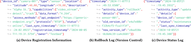
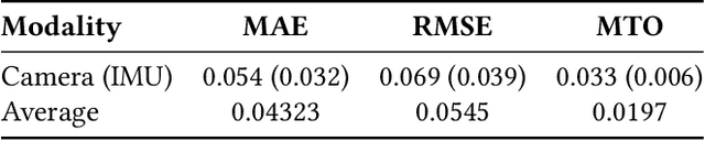
As urban populations grow, cities are becoming more complex, driving the deployment of interconnected sensing systems to realize the vision of smart cities. These systems aim to improve safety, mobility, and quality of life through applications that integrate diverse sensors with real-time decision-making. Streetscape applications-focusing on challenges like pedestrian safety and adaptive traffic management-depend on managing distributed, heterogeneous sensor data, aligning information across time and space, and enabling real-time processing. These tasks are inherently complex and often difficult to scale. The Streetscape Application Services Stack (SASS) addresses these challenges with three core services: multimodal data synchronization, spatiotemporal data fusion, and distributed edge computing. By structuring these capabilities as clear, composable abstractions with clear semantics, SASS allows developers to scale streetscape applications efficiently while minimizing the complexity of multimodal integration. We evaluated SASS in two real-world testbed environments: a controlled parking lot and an urban intersection in a major U.S. city. These testbeds allowed us to test SASS under diverse conditions, demonstrating its practical applicability. The Multimodal Data Synchronization service reduced temporal misalignment errors by 88%, achieving synchronization accuracy within 50 milliseconds. Spatiotemporal Data Fusion service improved detection accuracy for pedestrians and vehicles by over 10%, leveraging multicamera integration. The Distributed Edge Computing service increased system throughput by more than an order of magnitude. Together, these results show how SASS provides the abstractions and performance needed to support real-time, scalable urban applications, bridging the gap between sensing infrastructure and actionable streetscape intelligence.
Boundless: Generating Photorealistic Synthetic Data for Object Detection in Urban Streetscapes
Sep 04, 2024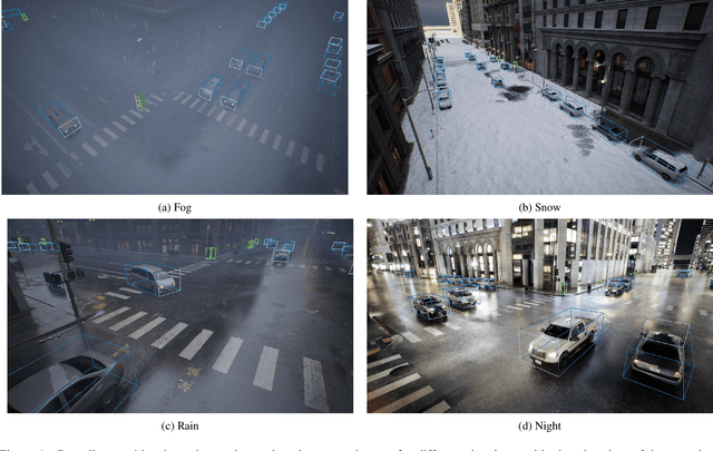
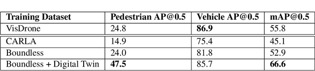
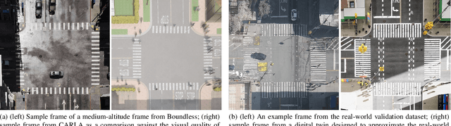
We introduce Boundless, a photo-realistic synthetic data generation system for enabling highly accurate object detection in dense urban streetscapes. Boundless can replace massive real-world data collection and manual ground-truth object annotation (labeling) with an automated and configurable process. Boundless is based on the Unreal Engine 5 (UE5) City Sample project with improvements enabling accurate collection of 3D bounding boxes across different lighting and scene variability conditions. We evaluate the performance of object detection models trained on the dataset generated by Boundless when used for inference on a real-world dataset acquired from medium-altitude cameras. We compare the performance of the Boundless-trained model against the CARLA-trained model and observe an improvement of 7.8 mAP. The results we achieved support the premise that synthetic data generation is a credible methodology for training/fine-tuning scalable object detection models for urban scenes.
Data-Driven Traffic Simulation for an Intersection in a Metropolis
Aug 01, 2024
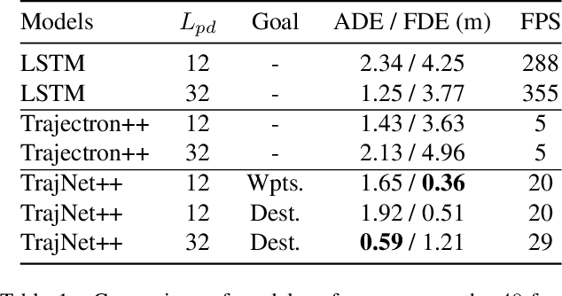
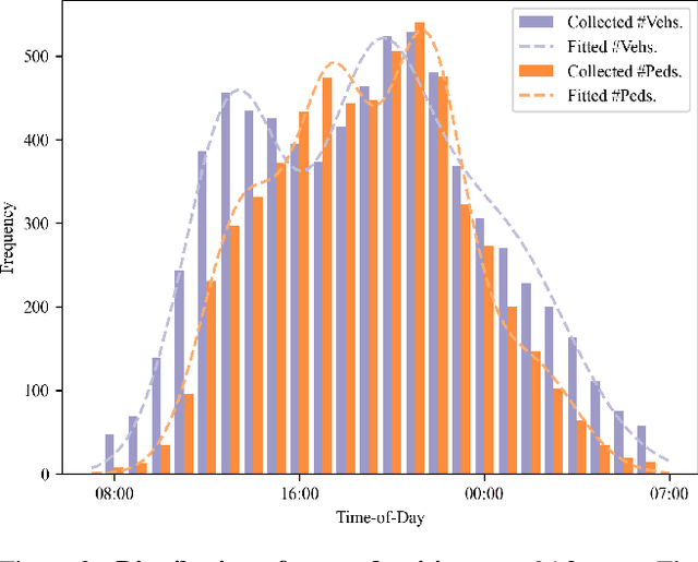
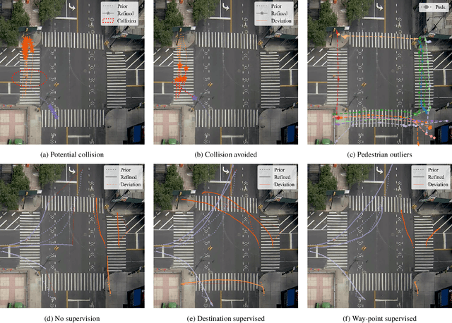
We present a novel data-driven simulation environment for modeling traffic in metropolitan street intersections. Using real-world tracking data collected over an extended period of time, we train trajectory forecasting models to learn agent interactions and environmental constraints that are difficult to capture conventionally. Trajectories of new agents are first coarsely generated by sampling from the spatial and temporal generative distributions, then refined using state-of-the-art trajectory forecasting models. The simulation can run either autonomously, or under explicit human control conditioned on the generative distributions. We present the experiments for a variety of model configurations. Under an iterative prediction scheme, the way-point-supervised TrajNet++ model obtained 0.36 Final Displacement Error (FDE) in 20 FPS on an NVIDIA A100 GPU.
Constellation Dataset: Benchmarking High-Altitude Object Detection for an Urban Intersection
Apr 25, 2024
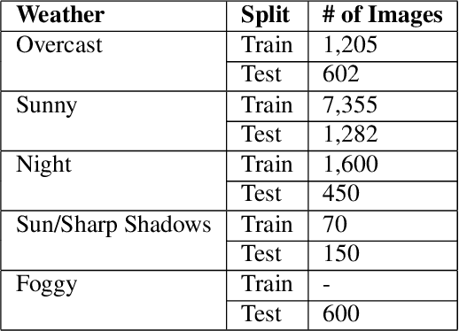
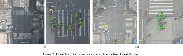
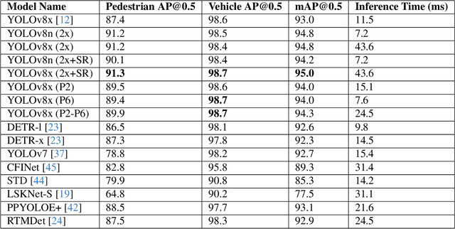
We introduce Constellation, a dataset of 13K images suitable for research on detection of objects in dense urban streetscapes observed from high-elevation cameras, collected for a variety of temporal conditions. The dataset addresses the need for curated data to explore problems in small object detection exemplified by the limited pixel footprint of pedestrians observed tens of meters from above. It enables the testing of object detection models for variations in lighting, building shadows, weather, and scene dynamics. We evaluate contemporary object detection architectures on the dataset, observing that state-of-the-art methods have lower performance in detecting small pedestrians compared to vehicles, corresponding to a 10% difference in average precision (AP). Using structurally similar datasets for pretraining the models results in an increase of 1.8% mean AP (mAP). We further find that incorporating domain-specific data augmentations helps improve model performance. Using pseudo-labeled data, obtained from inference outcomes of the best-performing models, improves the performance of the models. Finally, comparing the models trained using the data collected in two different time intervals, we find a performance drift in models due to the changes in intersection conditions over time. The best-performing model achieves a pedestrian AP of 92.0% with 11.5 ms inference time on NVIDIA A100 GPUs, and an mAP of 95.4%.