 Add to Chrome
 Add to Firefox
 Add to Edge
Counting Trees from Satellite Imagery with Noisy Supervision
Jun 25, 2026
Counting individual trees is a fundamental task for environmental monitoring, yet remains largely unexplored with satellite imagery. At these resolutions, isolated trees may still be identifiable, but crown boundaries become ambiguous in dense forests, making the notion of an individual tree inherently ill-defined. Moreover, large-scale manual annotations of individual trees are prohibitively expensive. While scalable supervision can be derived from airborne LiDAR, the resulting annotations are noisy and difficult to exploit effectively. We address these challenges by formulating tree counting as a spatial density matching problem supervised through Unbalanced Optimal Transport. This formulation naturally accommodates both precise localization of isolate trees and robust density estimation in dense forests. We further introduce a self-correction mechanism that leverages transport residuals to progressively refine noisy supervision during training. We evaluate our approach on TinyTrees, a new benchmark spanning three continents and three satellite sensors, comprising over 216 million tree annotations (including 639k manually verified instances) across $25\,890$ km$^2$. Our method consistently outperforms detection-based, regression-based, and transport-based distribution-matching baselines, demonstrating the effectiveness of unbalanced transport and reliability-aware supervision for large-scale tree counting from satellite imagery. Code, data and models are available at https://github.com/dgominski/treematch.

Mining Field Data for Tree Species Recognition at Scale
Aug 28, 2024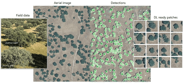

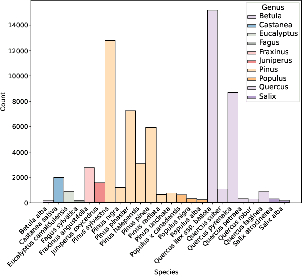
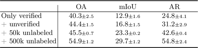
Individual tree species labels are particularly hard to acquire due to the expert knowledge needed and the limitations of photointerpretation. Here, we present a methodology to automatically mine species labels from public forest inventory data, using available pretrained tree detection models. We identify tree instances in aerial imagery and match them with field data with close to zero human involvement. We conduct a series of experiments on the resulting dataset, and show a beneficial effect when adding noisy or even unlabeled data points, highlighting a strong potential for large-scale individual species mapping.
Benchmarking Individual Tree Mapping with Sub-meter Imagery
Nov 14, 2023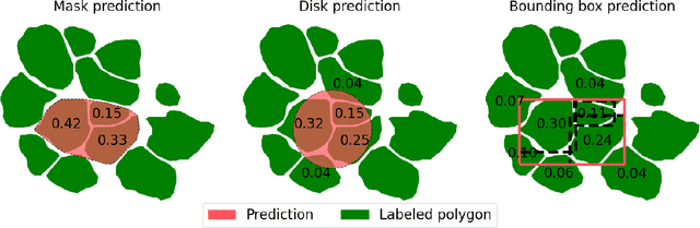
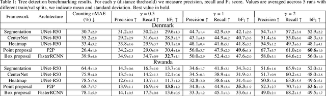
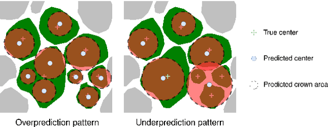
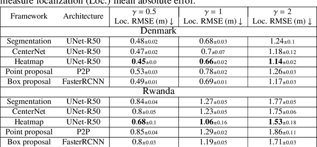
There is a rising interest in mapping trees using satellite or aerial imagery, but there is no standardized evaluation protocol for comparing and enhancing methods. In dense canopy areas, the high variability of tree sizes and their spatial proximity makes it arduous to define the quality of the predictions. Concurrently, object-centric approaches such as bounding box detection usuallyperform poorly on small and dense objects. It thus remains unclear what is the ideal framework for individual tree mapping, in regards to detection and segmentation approaches, convolutional neural networks and transformers. In this paper, we introduce an evaluation framework suited for individual tree mapping in any physical environment, with annotation costs and applicative goals in mind. We review and compare different approaches and deep architectures, and introduce a new method that we experimentally prove to be a good compromise between segmentation and detection.