 Add to Chrome
 Add to Firefox
 Add to Edge
Inverse design of the transmission matrix in a random system using Reinforcement Learning
Jun 16, 2025


This work presents an approach to the inverse design of scattering systems by modifying the transmission matrix using reinforcement learning. We utilize Proximal Policy Optimization to navigate the highly non-convex landscape of the object function to achieve three types of transmission matrices: (1) Fixed-ratio power conversion and zero-transmission mode in rank-1 matrices, (2) exceptional points with degenerate eigenvalues and unidirectional mode conversion, and (3) uniform channel participation is enforced when transmission eigenvalues are degenerate.
SounDiT: Geo-Contextual Soundscape-to-Landscape Generation
May 19, 2025


We present a novel and practically significant problem-Geo-Contextual Soundscape-to-Landscape (GeoS2L) generation-which aims to synthesize geographically realistic landscape images from environmental soundscapes. Prior audio-to-image generation methods typically rely on general-purpose datasets and overlook geographic and environmental contexts, resulting in unrealistic images that are misaligned with real-world environmental settings. To address this limitation, we introduce a novel geo-contextual computational framework that explicitly integrates geographic knowledge into multimodal generative modeling. We construct two large-scale geo-contextual multimodal datasets, SoundingSVI and SonicUrban, pairing diverse soundscapes with real-world landscape images. We propose SounDiT, a novel Diffusion Transformer (DiT)-based model that incorporates geo-contextual scene conditioning to synthesize geographically coherent landscape images. Furthermore, we propose a practically-informed geo-contextual evaluation framework, the Place Similarity Score (PSS), across element-, scene-, and human perception-levels to measure consistency between input soundscapes and generated landscape images. Extensive experiments demonstrate that SounDiT outperforms existing baselines in both visual fidelity and geographic settings. Our work not only establishes foundational benchmarks for GeoS2L generation but also highlights the importance of incorporating geographic domain knowledge in advancing multimodal generative models, opening new directions at the intersection of generative AI, geography, urban planning, and environmental sciences.
Generative AI for Autonomous Driving: Frontiers and Opportunities
May 13, 2025Generative Artificial Intelligence (GenAI) constitutes a transformative technological wave that reconfigures industries through its unparalleled capabilities for content creation, reasoning, planning, and multimodal understanding. This revolutionary force offers the most promising path yet toward solving one of engineering's grandest challenges: achieving reliable, fully autonomous driving, particularly the pursuit of Level 5 autonomy. This survey delivers a comprehensive and critical synthesis of the emerging role of GenAI across the autonomous driving stack. We begin by distilling the principles and trade-offs of modern generative modeling, encompassing VAEs, GANs, Diffusion Models, and Large Language Models (LLMs). We then map their frontier applications in image, LiDAR, trajectory, occupancy, video generation as well as LLM-guided reasoning and decision making. We categorize practical applications, such as synthetic data workflows, end-to-end driving strategies, high-fidelity digital twin systems, smart transportation networks, and cross-domain transfer to embodied AI. We identify key obstacles and possibilities such as comprehensive generalization across rare cases, evaluation and safety checks, budget-limited implementation, regulatory compliance, ethical concerns, and environmental effects, while proposing research plans across theoretical assurances, trust metrics, transport integration, and socio-technical influence. By unifying these threads, the survey provides a forward-looking reference for researchers, engineers, and policymakers navigating the convergence of generative AI and advanced autonomous mobility. An actively maintained repository of cited works is available at https://github.com/taco-group/GenAI4AD.
InteractiveVideo: User-Centric Controllable Video Generation with Synergistic Multimodal Instructions
Feb 05, 2024We introduce $\textit{InteractiveVideo}$, a user-centric framework for video generation. Different from traditional generative approaches that operate based on user-provided images or text, our framework is designed for dynamic interaction, allowing users to instruct the generative model through various intuitive mechanisms during the whole generation process, e.g. text and image prompts, painting, drag-and-drop, etc. We propose a Synergistic Multimodal Instruction mechanism, designed to seamlessly integrate users' multimodal instructions into generative models, thus facilitating a cooperative and responsive interaction between user inputs and the generative process. This approach enables iterative and fine-grained refinement of the generation result through precise and effective user instructions. With $\textit{InteractiveVideo}$, users are given the flexibility to meticulously tailor key aspects of a video. They can paint the reference image, edit semantics, and adjust video motions until their requirements are fully met. Code, models, and demo are available at https://github.com/invictus717/InteractiveVideo
Artificial Intelligence Studies in Cartography: A Review and Synthesis of Methods, Applications, and Ethics
Dec 13, 2023The past decade has witnessed the rapid development of geospatial artificial intelligence (GeoAI) primarily due to the ground-breaking achievements in deep learning and machine learning. A growing number of scholars from cartography have demonstrated successfully that GeoAI can accelerate previously complex cartographic design tasks and even enable cartographic creativity in new ways. Despite the promise of GeoAI, researchers and practitioners have growing concerns about the ethical issues of GeoAI for cartography. In this paper, we conducted a systematic content analysis and narrative synthesis of research studies integrating GeoAI and cartography to summarize current research and development trends regarding the usage of GeoAI for cartographic design. Based on this review and synthesis, we first identify dimensions of GeoAI methods for cartography such as data sources, data formats, map evaluations, and six contemporary GeoAI models, each of which serves a variety of cartographic tasks. These models include decision trees, knowledge graph and semantic web technologies, deep convolutional neural networks, generative adversarial networks, graph neural networks, and reinforcement learning. Further, we summarize seven cartographic design applications where GeoAI have been effectively employed: generalization, symbolization, typography, map reading, map interpretation, map analysis, and map production. We also raise five potential ethical challenges that need to be addressed in the integration of GeoAI for cartography: commodification, responsibility, privacy, bias, and (together) transparency, explainability, and provenance. We conclude by identifying four potential research directions for future cartographic research with GeoAI: GeoAI-enabled active cartographic symbolism, human-in-the-loop GeoAI for cartography, GeoAI-based mapping-as-a-service, and generative GeoAI for cartography.
Understanding Place Identity with Generative AI
Jun 07, 2023Researchers are constantly leveraging new forms of data with the goal of understanding how people perceive the built environment and build the collective place identity of cities. Latest advancements in generative artificial intelligence (AI) models have enabled the production of realistic representations learned from vast amounts of data. In this study, we aim to test the potential of generative AI as the source of textual and visual information in capturing the place identity of cities assessed by filtered descriptions and images. We asked questions on the place identity of a set of 31 global cities to two generative AI models, ChatGPT and DALL-E2. Since generative AI has raised ethical concerns regarding its trustworthiness, we performed cross-validation to examine whether the results show similar patterns to real urban settings. In particular, we compared the outputs with Wikipedia data for text and images searched from Google for image. Our results indicate that generative AI models have the potential to capture the collective image of cities that can make them distinguishable. This study is among the first attempts to explore the capabilities of generative AI in understanding human perceptions of the built environment. It contributes to urban design literature by discussing future research opportunities and potential limitations.
STICC: A multivariate spatial clustering method for repeated geographic pattern discovery with consideration of spatial contiguity
Mar 31, 2022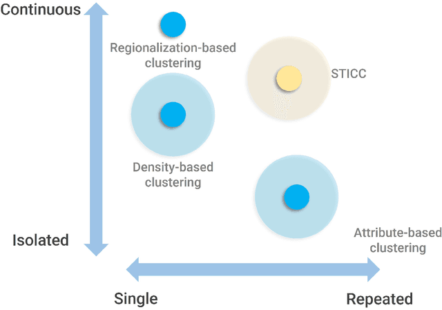
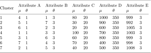
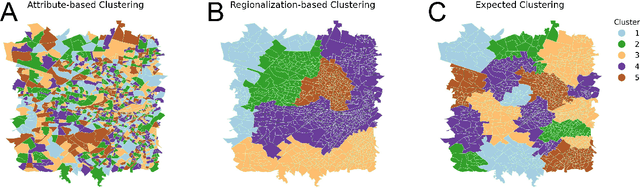
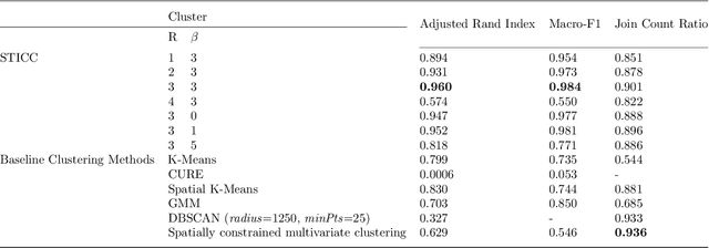
Spatial clustering has been widely used for spatial data mining and knowledge discovery. An ideal multivariate spatial clustering should consider both spatial contiguity and aspatial attributes. Existing spatial clustering approaches may face challenges for discovering repeated geographic patterns with spatial contiguity maintained. In this paper, we propose a Spatial Toeplitz Inverse Covariance-Based Clustering (STICC) method that considers both attributes and spatial relationships of geographic objects for multivariate spatial clustering. A subregion is created for each geographic object serving as the basic unit when performing clustering. A Markov random field is then constructed to characterize the attribute dependencies of subregions. Using a spatial consistency strategy, nearby objects are encouraged to belong to the same cluster. To test the performance of the proposed STICC algorithm, we apply it in two use cases. The comparison results with several baseline methods show that the STICC outperforms others significantly in terms of adjusted rand index and macro-F1 score. Join count statistics is also calculated and shows that the spatial contiguity is well preserved by STICC. Such a spatial clustering method may benefit various applications in the fields of geography, remote sensing, transportation, and urban planning, etc.
LSTM-TrajGAN: A Deep Learning Approach to Trajectory Privacy Protection
Jun 14, 2020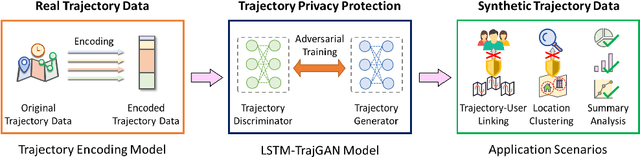
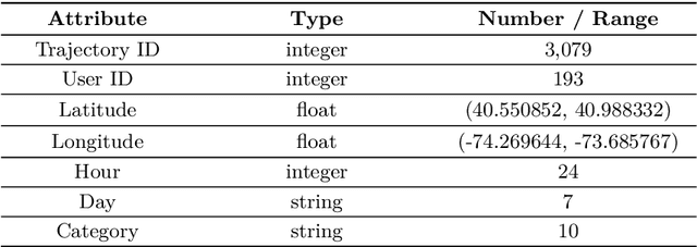
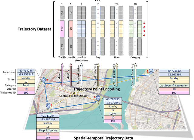
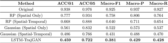
The prevalence of location-based services contributes to the explosive growth of individual-level trajectory data and raises public concerns about privacy issues. In this research, we propose a novel LSTM-TrajGAN approach, which is an end-to-end deep learning model to generate privacy-preserving synthetic trajectory data for data sharing and publication. We design a loss metric function TrajLoss to measure the trajectory similarity losses for model training and optimization. The model is evaluated on the trajectory-user-linking task on a real-world semantic trajectory dataset. Compared with other common geomasking methods, our model can better prevent users from being re-identified, and it also preserves essential spatial, temporal, and thematic characteristics of the real trajectory data. The model better balances the effectiveness of trajectory privacy protection and the utility for spatial and temporal analyses, which offers new insights into the GeoAI-powered privacy protection.
Transferring Multiscale Map Styles Using Generative Adversarial Networks
May 18, 2019


The advancement of the Artificial Intelligence (AI) technologies makes it possible to learn stylistic design criteria from existing maps or other visual art and transfer these styles to make new digital maps. In this paper, we propose a novel framework using AI for map style transfer applicable across multiple map scales. Specifically, we identify and transfer the stylistic elements from a target group of visual examples, including Google Maps, OpenStreetMap, and artistic paintings, to unstylized GIS vector data through two generative adversarial network (GAN) models. We then train a binary classifier based on a deep convolutional neural network to evaluate whether the transfer styled map images preserve the original map design characteristics. Our experiment results show that GANs have a great potential for multiscale map style transferring, but many challenges remain requiring future research.
* 12 pages, 17 figure
Extracting human emotions at different places based on facial expressions and spatial clustering analysis
May 06, 2019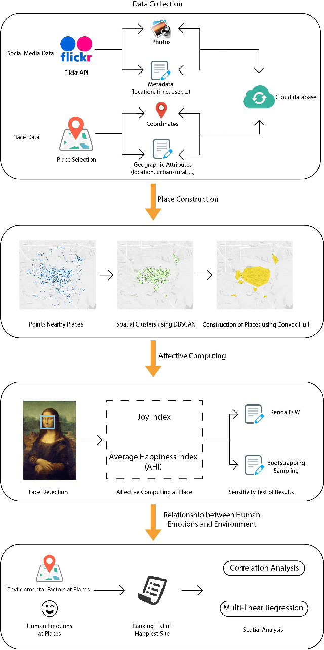
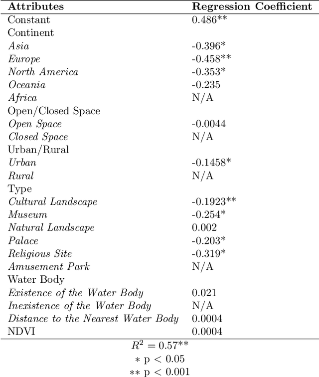
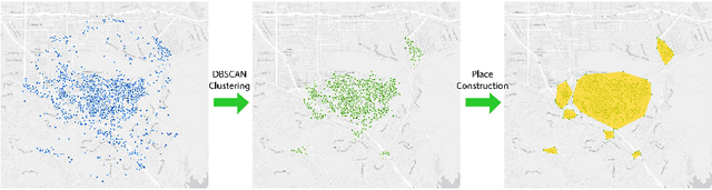
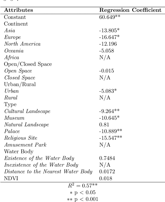
The emergence of big data enables us to evaluate the various human emotions at places from a statistic perspective by applying affective computing. In this study, a novel framework for extracting human emotions from large-scale georeferenced photos at different places is proposed. After the construction of places based on spatial clustering of user generated footprints collected in social media websites, online cognitive services are utilized to extract human emotions from facial expressions using the state-of-the-art computer vision techniques. And two happiness metrics are defined for measuring the human emotions at different places. To validate the feasibility of the framework, we take 80 tourist attractions around the world as an example and a happiness ranking list of places is generated based on human emotions calculated over 2 million faces detected out from over 6 million photos. Different kinds of geographical contexts are taken into consideration to find out the relationship between human emotions and environmental factors. Results show that much of the emotional variation at different places can be explained by a few factors such as openness. The research may offer insights on integrating human emotions to enrich the understanding of sense of place in geography and in place-based GIS.
* 40 pages; 9 figures