 Add to Chrome
 Add to Firefox
 Add to Edge
Tales of the 2025 Los Angeles Fire: Hotwash for Public Health Concerns in Reddit via LLM-Enhanced Topic Modeling
May 14, 2025Wildfires have become increasingly frequent, irregular, and severe in recent years. Understanding how affected populations perceive and respond during wildfire crises is critical for timely and empathetic disaster response. Social media platforms offer a crowd-sourced channel to capture evolving public discourse, providing hyperlocal information and insight into public sentiment. This study analyzes Reddit discourse during the 2025 Los Angeles wildfires, spanning from the onset of the disaster to full containment. We collect 385 posts and 114,879 comments related to the Palisades and Eaton fires. We adopt topic modeling methods to identify the latent topics, enhanced by large language models (LLMs) and human-in-the-loop (HITL) refinement. Furthermore, we develop a hierarchical framework to categorize latent topics, consisting of two main categories, Situational Awareness (SA) and Crisis Narratives (CN). The volume of SA category closely aligns with real-world fire progressions, peaking within the first 2-5 days as the fires reach the maximum extent. The most frequent co-occurring category set of public health and safety, loss and damage, and emergency resources expands on a wide range of health-related latent topics, including environmental health, occupational health, and one health. Grief signals and mental health risks consistently accounted for 60 percentage and 40 percentage of CN instances, respectively, with the highest total volume occurring at night. This study contributes the first annotated social media dataset on the 2025 LA fires, and introduces a scalable multi-layer framework that leverages topic modeling for crisis discourse analysis. By identifying persistent public health concerns, our results can inform more empathetic and adaptive strategies for disaster response, public health communication, and future research in comparable climate-related disaster events.
Learning county from pixels: Corn yield prediction with attention-weighted multiple instance learning
Dec 02, 2023Remote sensing technology has become a promising tool in yield prediction. Most prior work employs satellite imagery for county-level corn yield prediction by spatially aggregating all pixels within a county into a single value, potentially overlooking the detailed information and valuable insights offered by more granular data. To this end, this research examines each county at the pixel level and applies multiple instance learning to leverage detailed information within a county. In addition, our method addresses the "mixed pixel" issue caused by the inconsistent resolution between feature datasets and crop mask, which may introduce noise into the model and therefore hinder accurate yield prediction. Specifically, the attention mechanism is employed to automatically assign weights to different pixels, which can mitigate the influence of mixed pixels. The experimental results show that the developed model outperforms four other machine learning models over the past five years in the U.S. corn belt and demonstrates its best performance in 2022, achieving a coefficient of determination (R2) value of 0.84 and a root mean square error (RMSE) of 0.83. This paper demonstrates the advantages of our approach from both spatial and temporal perspectives. Furthermore, through an in-depth study of the relationship between mixed pixels and attention, it is verified that our approach can capture critical feature information while filtering out noise from mixed pixels.
LSTM-TrajGAN: A Deep Learning Approach to Trajectory Privacy Protection
Jun 14, 2020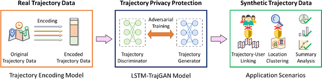
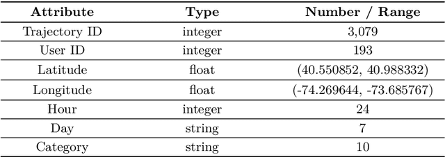
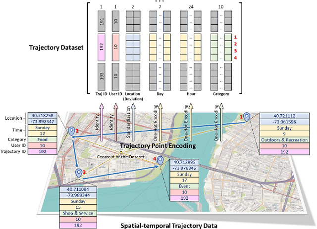
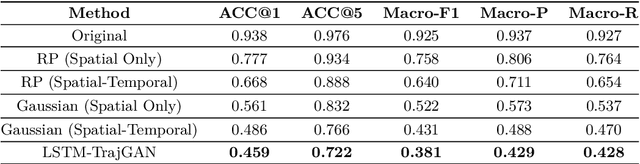
The prevalence of location-based services contributes to the explosive growth of individual-level trajectory data and raises public concerns about privacy issues. In this research, we propose a novel LSTM-TrajGAN approach, which is an end-to-end deep learning model to generate privacy-preserving synthetic trajectory data for data sharing and publication. We design a loss metric function TrajLoss to measure the trajectory similarity losses for model training and optimization. The model is evaluated on the trajectory-user-linking task on a real-world semantic trajectory dataset. Compared with other common geomasking methods, our model can better prevent users from being re-identified, and it also preserves essential spatial, temporal, and thematic characteristics of the real trajectory data. The model better balances the effectiveness of trajectory privacy protection and the utility for spatial and temporal analyses, which offers new insights into the GeoAI-powered privacy protection.