 Add to Chrome
 Add to Firefox
 Add to Edge
More Than Where You Are: Learning Semantics, Structure, and Geometry from Cross-View Localization
Jul 14, 2026
Consistent cross-view understanding under extreme viewpoint changes is essential for spatial intelligence, as it enables models to recognize the same scene across extreme viewpoint gaps. Cross-view localization naturally provides a promising pathway toward this ability, as it requires a model to align ground-view imagery with geo-referenced satellite-view imagery despite drastic appearance changes to estimate camera poses. Recent visual foundation models have made this long-standing localization problem increasingly feasible by providing rich 2D representations for cross-view matching. However, we argue that cross-view localization should not be viewed merely as 2D matching or pose estimation. In this work, we revisit cross-view localization as more than pose estimation and investigate how it can help the model develop consistent cross-view understanding under extreme viewpoint changes, including stable semantics, reliable structure, and transferable geometry. We identify three key limitations of existing methods that prevent them from achieving this. They usually lack explicit 3D grounding, rely on strict point-wise matching that can weaken semantic consistency, and learn from an absolute objective that provides limited guidance for geometric reasoning. To address these limitations, we propose CROSS, a unified cross-view localization framework built upon 3D-grounded alignment, structure-aware matching, and hypothesis ranking. This formulation makes structure learning an intrinsic requirement, encourages semantic representations to remain stable, and enables the model to acquire transferable geometry. Extensive experiments on the KITTI and VIGOR datasets show that CROSS achieves state-of-the-art performance in cross-view localization. More importantly, CROSS effectively learns stable semantics, reliable structure, and transferable geometry across extremely different viewpoints.

PanoWorld: Real-World Panoramic Generation
Jul 10, 2026In this work, we aim to address the challenge of long-range memory in panoramic world models by exploiting the rotation-equivariant property of omnidirectional representations, where rotation can be treated as an implicit geometric transformation.Building on this insight, we propose PanoWorld, which simplifies camera trajectories into translations via fixed headings for both current-action modeling and long-range memory through Dense Panoramic Ray-Conditioning (DPRC) and Geometry-aware Memory Augmentation (GMA).Then, a three-stage training pipeline is introduced to progressively optimize each component. To better evaluate physical consistency under large-scale spatial variations and diverse illumination conditions, where existing datasets are relatively stable, we construct World360, a large-scale dataset consisting of both real-world video clips collected via panoramic unmanned aerial vehicles and high-quality simulated clips generated by AirSim360.Extensive experiments on World360 demonstrate the effectiveness of PanoWorld, outperforming alternative methods by a large margin.Our models, training code, and dataset will be publicly available. More information can be found on our project page: https://lihaoy-ux.github.io/panoworld-page/.
Globally Localizing Lunar Rover in Pixels via Graph Alignment
Jun 09, 2026Precise rover localization is a prerequisite for autonomous lunar exploration, yet the absence of Global Navigation Satellite System (GNSS) signals and the cumulative drift of local localization methods severely constrain long-range missions. Cross-view localization provides a promising drift-free global solution by matching rover-view and satellite-view imagery. However, the lunar environment poses unique challenges for correspondence alignment, including inter-entity entanglement, inter-viewpoint divergence, and simulation-to-real domain shift. To address these challenges, we propose Warped Alignment of Reprojected Graphs (WARG), a framework that leverages unified graph learning and reprojected graph matching for robust cross-view alignment. Pretrained on the synthetic LuSNAR dataset, WARG achieves an average test error of 0.32 m and demonstrates robust zero-shot generalization to the synthetic lunar south pole region with an error of 3.63 m. More importantly, when validated on real-world data from the YuTu-2 rover, WARG achieves a localization error of 1.68 m within a 100 m x 100 m search area, corresponding to nearly one-pixel precision in low-resolution satellite imagery with a spatial resolution of 1.40 m/pixel. Beyond accuracy, WARG is computationally efficient, containing only 1.56M parameters, corresponding to 16.12% of previous lightweight models, and operating at 5.49 Hz on an NVIDIA RTX A6000 GPU, approaching GNSS-level update frequency. Finally, we observe that WARG naturally develops low-level spatial awareness, including semantic segmentation and structural reasoning, through cross-view localization learning, highlighting its potential as a promising paradigm for spatial intelligence with minimal annotation cost. The source code is available at https://github.com/maochen-casia/warg.
Hierarchical Image Matching for UAV Absolute Visual Localization via Semantic and Structural Constraints
Jun 11, 2025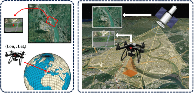
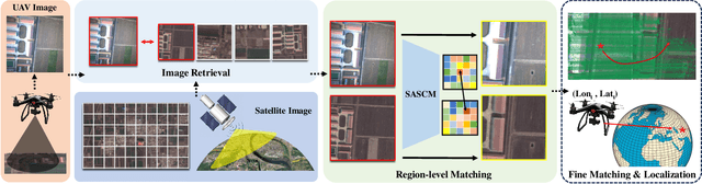
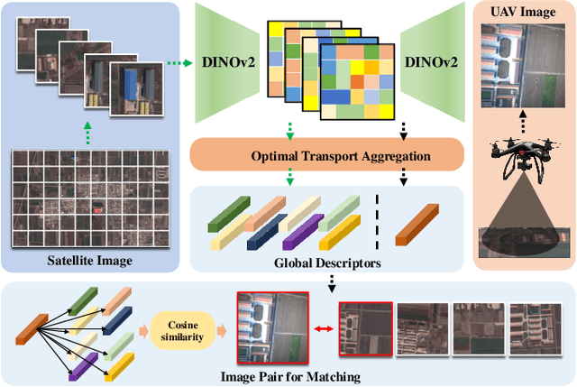
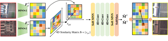
Absolute localization, aiming to determine an agent's location with respect to a global reference, is crucial for unmanned aerial vehicles (UAVs) in various applications, but it becomes challenging when global navigation satellite system (GNSS) signals are unavailable. Vision-based absolute localization methods, which locate the current view of the UAV in a reference satellite map to estimate its position, have become popular in GNSS-denied scenarios. However, existing methods mostly rely on traditional and low-level image matching, suffering from difficulties due to significant differences introduced by cross-source discrepancies and temporal variations. To overcome these limitations, in this paper, we introduce a hierarchical cross-source image matching method designed for UAV absolute localization, which integrates a semantic-aware and structure-constrained coarse matching module with a lightweight fine-grained matching module. Specifically, in the coarse matching module, semantic features derived from a vision foundation model first establish region-level correspondences under semantic and structural constraints. Then, the fine-grained matching module is applied to extract fine features and establish pixel-level correspondences. Building upon this, a UAV absolute visual localization pipeline is constructed without any reliance on relative localization techniques, mainly by employing an image retrieval module before the proposed hierarchical image matching modules. Experimental evaluations on public benchmark datasets and a newly introduced CS-UAV dataset demonstrate superior accuracy and robustness of the proposed method under various challenging conditions, confirming its effectiveness.