 Add to Chrome
 Add to Firefox
 Add to Edge
Beyond Legacy OFDM: A Mobility-Adaptive Multi-Gear Framework for 6G
Mar 31, 2026While Third Generation Partnership Project (3GPP) has confirmed orthogonal frequency division multiplexing (OFDM) as the baseline waveform for sixth-generation (6G), its performance is severely compromised in the high-mobility scenarios envisioned for 6G. Building upon the GEARBOX-PHY vision, we present gear-switching OFDM (GS-OFDM): a unified framework in which the base station (BS) adaptively selects among three gears, ranging from legacy OFDM to delay-Doppler domain processing based on the channel mobility conditions experienced by the user equipments (UEs). We illustrate the benefit of adaptive gear switching for communication throughput and, finally, we conclude with an outlook on research challenges and opportunities.
Mobile Radio Networks and Weather Radars Dualism: Rainfall Measurement Revolution in Densely Populated Areas
Mar 19, 2026This study demonstrates, for the first time, how a network of cellular base stations (BSs) - the infrastructure of mobile radio networks - can be used as a distributed opportunistic radar for rainfall remote sensing. By adapting signal-processing techniques traditionally employed in Doppler weather radar systems, we demonstrate that BS signals can be used to retrieve typical weather radar products, including reflectivity factor, mean Doppler velocity, and spectral width. Due to the high spatial density of BS infrastructure in urban environments, combined with intrinsic technical features such as electronically steerable antenna arrays and wide receiver bandwidths, the proposed approach achieves unprecedented spatial and temporal resolutions, on the order of a few meters and several tens of seconds, respectively. Despite limitations related to low transmitted power, limited antenna gain, and other system constraints, a major challenge arises from ground clutter contamination, which is exacerbated by the nearly horizontal orientation of BS antenna beams. This work provides a thorough assessment of clutter impact and demonstrates that, through appropriate processing, the resulting clutter-filtered radar moments reach a satisfactory level of quality when compared with raw observations and with measurements from independent BSs with overlapped field-of-views. The findings highlight a transformative opportunity for urban hydrometeorology: leveraging existing telecommunications infrastructure to obtain rainfall information with a level of spatial granularity and temporal immediacy like never before.
NLOS-Aided Joint OTA Synchronization and Off-Grid Imaging for Distributed MIMO Systems
Mar 14, 2026Distributed multiple-input multiple-output (MIMO) architectures enable large-scale integrated sensing and communication (ISAC) by providing high spatial resolution and robustness through spatial diversity. However, practical phase-coherent sensing is challenged by phase synchronization errors and modeling mismatch caused by grid discretization. Existing over-the-air (OTA) synchronization methods typically treat synchronization and sensing tasks separately, which may lead to inaccurate phase alignment when multipath components are used for imaging. In this paper, we propose a non-line-of-sight (NLOS)-aided joint OTA synchronization and off-grid imaging framework for distributed MIMO ISAC systems. First, a line-of-sight (LOS)-assisted coarse synchronization is performed to establish initial phase coherence across distributed links. Subsequently, an iterative refinement stage exploits reconstructed NLOS components obtained from imaging results. By modeling off-grid effects via a first-order Taylor expansion, we transform measurements with nonlinear off-grid offset into an augmented linear model with jointly sparse reflectivity and off-set variables. The imaging problem is reformulated as a structured sparse recovery task and solved using a tailored off-grid approximate message passing (OG-AMP) algorithm. The imaging and synchronization modules are coupled within a closed-loop alternative optimization framework, where improved imaging enables more accurate phase refinement, and vice versa. Numerical results show that the proposed framework achieves accurate synchronization and imaging under phase errors. Compared with conventional approaches, it shows superior robustness and accuracy.
POLO: Phase-Only Localization in Uplink Distributed MIMO Systems
Dec 10, 2025


We propose a low-complexity localization framework for uplink distributed MIMO (D-MIMO) systems, targeting the challenge of minimizing the highly spiky maximum-likelihood (ML) cost function that arises in sparsely deployed phasecoherent access points (APs) with narrowband transmission. In such systems, ML-based localization typically relies on dense grid search, incurring prohibitive computational complexity. To address this, we introduce phase-only localization (POLO), an approach that leverages differential carrier-phase measurements from selected APs to generate a compact set of candidate user positions. The ML cost function is then evaluated only at these candidates, reducing complexity significantly. A key challenge is to devise an AP selection mechanism that reduces the number of candidate points while maintaining reliable coverage. We propose two variants: POLO-I, which selects three APs to provide closed-form candidate positions with low computational cost, and POLO-II, which selects four APs using an alternative strategy that enhances coverage at marginally higher runtime. Comprehensive analytical and simulation results show that POLO achieves a favorable coverage-complexity trade-off, reducing cost by orders of magnitude relative to exhaustive grid search with only marginal loss in coverage. By characterizing this tradeoff under diverse AP configurations, we also provide practical guidelines for selecting between POLO-I and POLO-II depending on latency and coverage requirements.
Enabling NLOS Imaging Capabilities at the Initial Access of 6G Base Stations
Nov 19, 2025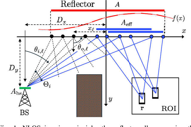
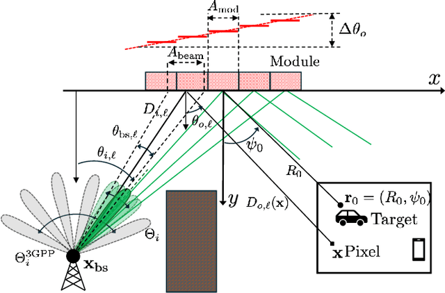
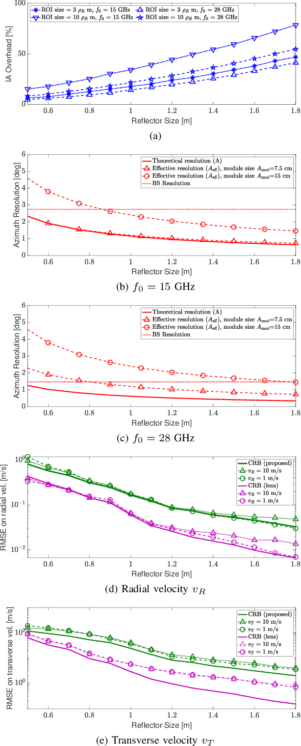
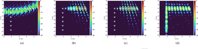
Sensing in non-line-of-sight (NLOS) is one of the major challenges for integrated sensing and communication systems. Existing countermeasures for NLOS either use prior knowledge on the environment to characterize all the multiple bounces or deploy anomalous reflectors in the environment to enable communication infrastructure to ''\textit{see behind the corner}''. This work addresses the integration of monostatic NLOS imaging functionalities into the initial access (IA) procedure of a next generation base station (BS), by means of a non-reconfigurable modular reflector. During standard-compliant IA, the BS sweeps a narrow beam using a pre-defined dedicated codebook to achieve the beam alignment with users. We introduce the imaging functionality by enhancing such codebook with imaging-specific entries that are jointly designed with the angular configuration of the modular reflector to enable high-resolution imaging of a region in NLOS by \textit{coherently} processing all the echoes at the BS. We derive closed-form expressions for the near-field (NF) spatial resolution, as well as for the \textit{effective aperture} (i.e., the portion of the reflector that actively contributes to improve image resolution). The problem of imaging of moving targets in NLOS is also addressed, and we propose a maximum-likelihood estimation for target's velocity in NF and related theoretical bound. Further, we discuss and quantify the inherent communication-imaging performance trade-offs and related system design challenges through numerical simulations. Finally, the proposed imaging method employing modular reflectors is validated both numerically and experimentally, showing the effectiveness of our concept.
Integrating Phase-Coherent Multistatic Imaging in Downlink D-MIMO Networks
Oct 05, 2025


This paper addresses the challenge of integrating multistatic coherent imaging functionalities in the downlink (DL) of a phase-coherent distributed multiple input multiple output (D-MIMO) communication network. During DL, the D-MIMO access points (APs) jointly precode the transmitted signals to maximize the spectral efficiency (SE) at the users (UEs) locations. However, imaging requires that \textit{(i)} a fraction of the APs work as receivers for sensing and \textit{(ii)} the transmitting APs emit AP-specific and orthogonal signals to illuminate the area to be imaged and allow multistatic operation. In these settings, our contribution is twofold. We propose a novel distributed integrated sensing and communication (D-ISAC) system that superposes a purposely designed AP-specific signal for imaging to the legacy UE-specific communication one, with a tunable trade-off factor. We detail both the imaging waveform design according to the \textit{extended orthogonality condition} and the space-frequency precoder design. Then, we propose an optimized selection strategy for the receiving APs, in order to maximize imaging performance under half-duplex constraints. Extensive numerical results prove the feasibility and benefits of our proposal, materializing the potential of joint multistatic imaging and communications in practical D-MIMO deployments.
Bridging the Gap via Data-Aided Sensing: Can Bistatic ISAC Converge to Genie Performance?
May 02, 2025We investigate data-aided iterative sensing in bistatic OFDM ISAC systems, focusing on scenarios with co-located sensing and communication receivers. To enhance target detection beyond pilot-only sensing methods, we propose a multi-stage bistatic OFDM receiver, performing iterative sensing and data demodulation to progressively refine ISAC channel and data estimates. Simulation results demonstrate that the proposed data-aided scheme significantly outperforms pilot-only benchmarks, particularly in multi-target scenarios, substantially narrowing the performance gap compared to a genie-aided system with perfect data knowledge. Moreover, the proposed approach considerably expands the bistatic ISAC trade-off region, closely approaching the probability of detection-achievable rate boundary established by its genie-aided counterpart.
Joint Localization and Synchronization in Downlink Distributed MIMO
Apr 14, 2025


We investigate joint localization and synchronization in the downlink of a distributed multiple-input-multiple-output (D-MIMO) system, aiming to estimate the position and phase offset of a single-antenna user equipment (UE) using downlink transmissions of multiple phase-synchronized, multi-antenna access points (APs). We propose two transmission protocols: sequential (P1) and simultaneous (P2) AP transmissions, together with the ML estimators that either leverage (coherent estimator) or disregard phase information (non-coherent estimator). Simulation results reveal that downlink D-MIMO holds significant potential for high-accuracy localization while showing that P2 provides superior localization performance and reduced transmission latency.
MovISAC: Coherent Imaging of Moving Targets with Distributed Asynchronous ISAC Devices
Feb 12, 2025


Distributed integrated sensing and communication (ISAC) devices can overcome the traditional resolution limitations imposed by the signal bandwidth, cooperating to produce high-resolution images of the environment. However, existing phase-coherent imaging approaches are not suited to imaging multiple moving targets, since the Doppler effect causes a phase rotation that degrades the image focus and biases the targets' locations. In this paper, we propose MovISAC, the first coherent imaging method for moving targets using distributed asynchronous ISAC devices. Our approach obtains a set of high-resolution images of the environment, in which each image represents only targets moving with a selected velocity. To achieve this, MovISAC performs over-the-air (OTA) synchronization to compensate for timing, frequency, and phase offsets among distributed ISAC devices. Then, to solve the prohibitive complexity of an exhaustive search over the targets' velocities, we introduce a new association algorithm to match the Doppler shifts observed by each ISAC device pair to the corresponding spatial peaks obtained by standard imaging methods. This gives MovISAC the unique capability of pre-compensating the Doppler shift for each target before forming the images, thus recasting it from an undesired impairment to image formation to an additional means for resolving the targets. We perform extensive numerical simulations showing that our approach achieves extremely high resolution, superior robustness to clutter thanks to the additional target separation in the Doppler domain, and obtains cm- and cm/s-level target localization and velocity estimation errors. MovISAC significantly outperforms existing imaging methods that do not compensate for the Doppler shift, demonstrating up to 18 times lower localization error and enabling velocity estimation.
Optimal Planning for Heterogeneous Smart Radio Environments
Nov 23, 2024Smart Radio Environment (SRE) is a central paradigms in 6G and beyond, where integrating SRE components into the network planning process enables optimized performance for high-frequency Radio Access Network (RAN). This paper presents a comprehensive planning framework utilizing realistic urban scenarios and precise channel models to analyze diverse SRE components, including Reconfigurable Intelligent Surface (RIS), Network-Controlled Repeater (NCR), and advanced technologies like Simultaneous transmitting and reflecting RIS (STAR RIS) and trisectoral NCR (3SNCR). We propose two optimization methods, full coverage minimum cost (FCMC) and maximum budget-constrained coverage (MBCC), that address key cost and coverage objectives by considering both physical characteristics and scalable costs of each component, influenced by factors such as NCR amplification gain and RIS dimensions. Extensive numerical results demonstrate the significant impact of these models in enhancing network planning efficiency for high-density urban environments.