 Add to Chrome
 Add to Firefox
 Add to Edge
Partial recovery of meter-scale surface weather
Feb 26, 2026Near-surface atmospheric conditions can differ sharply over tens to hundreds of meters due to land cover and topography, yet this variability is absent from current weather analyses and forecasts. It is unclear whether such meter-scale variability reflects irreducibly chaotic dynamics or contains a component predictable from surface characteristics and large-scale atmospheric forcing. Here we show that a substantial, physically coherent component of meter-scale near-surface weather is statistically recoverable from existing observations. By conditioning coarse atmospheric state on sparse surface station measurements and high-resolution Earth observation data, we infer spatially continuous fields of near-surface wind, temperature, and humidity at 10 m resolution across the contiguous United States. Relative to ERA5, the inferred fields reduce wind error by 29% and temperature and dewpoint error by 6%, while explaining substantially more spatial variance at fixed time steps. They also exhibit physically interpretable structure, including urban heat islands, evapotranspiration-driven humidity contrasts, and wind speed differences across land cover types. Our findings expand the frontier of weather modeling by demonstrating a computationally feasible approach to continental-scale meter-resolution inference. More broadly, they illustrate how conditioning coarse dynamical models on static fine-scale features can reveal previously unresolved components of the Earth system.
PDE foundation models are skillful AI weather emulators for the Martian atmosphere
Feb 16, 2026We show that AI foundation models that are pretrained on numerical solutions to a diverse corpus of partial differential equations can be adapted and fine-tuned to obtain skillful predictive weather emulators for the Martian atmosphere. We base our work on the Poseidon PDE foundation model for two-dimensional systems. We develop a method to extend Poseidon from two to three dimensions while keeping the pretraining information. Moreover, we investigate the performance of the model in the presence of sparse initial conditions. Our results make use of four Martian years (approx.~34 GB) of training data and a median compute budget of 13 GPU hours. We find that the combination of pretraining and model extension yields a performance increase of 34.4\% on a held-out year. This shows that PDEs-FMs can not only approximate solutions to (other) PDEs but also anchor models for real-world problems with complex interactions that lack a sufficient amount of training data or a suitable compute budget.
Ecological mapping with geospatial foundation models
Feb 11, 2026Geospatial foundation models (GFMs) are a fast-emerging paradigm for various geospatial tasks, such as ecological mapping. However, the utility of GFMs has not been fully explored for high-value use cases. This study aims to explore the utility, challenges and opportunities associated with the application of GFMs for ecological uses. In this regard, we fine-tune several pretrained AI models, namely, Prithvi-E0-2.0 and TerraMind, across three use cases, and compare this with a baseline ResNet-101 model. Firstly, we demonstrate TerraMind's LULC generation capabilities. Lastly, we explore the utility of the GFMs in forest functional trait mapping and peatlands detection. In all experiments, the GFMs outperform the baseline ResNet models. In general TerraMind marginally outperforms Prithvi. However, with additional modalities TerraMind significantly outperforms the baseline ResNet and Prithvi models. Nonetheless, consideration should be given to the divergence of input data from pretrained modalities. We note that these models would benefit from higher resolution and more accurate labels, especially for use cases where pixel-level dynamics need to be mapped.
Prithvi-EO-2.0: A Versatile Multi-Temporal Foundation Model for Earth Observation Applications
Dec 03, 2024


This technical report presents Prithvi-EO-2.0, a new geospatial foundation model that offers significant improvements over its predecessor, Prithvi-EO-1.0. Trained on 4.2M global time series samples from NASA's Harmonized Landsat and Sentinel-2 data archive at 30m resolution, the new 300M and 600M parameter models incorporate temporal and location embeddings for enhanced performance across various geospatial tasks. Through extensive benchmarking with GEO-Bench, the 600M version outperforms the previous Prithvi-EO model by 8\% across a range of tasks. It also outperforms six other geospatial foundation models when benchmarked on remote sensing tasks from different domains and resolutions (i.e. from 0.1m to 15m). The results demonstrate the versatility of the model in both classical earth observation and high-resolution applications. Early involvement of end-users and subject matter experts (SMEs) are among the key factors that contributed to the project's success. In particular, SME involvement allowed for constant feedback on model and dataset design, as well as successful customization for diverse SME-led applications in disaster response, land use and crop mapping, and ecosystem dynamics monitoring. Prithvi-EO-2.0 is available on Hugging Face and IBM terratorch, with additional resources on GitHub. The project exemplifies the Trusted Open Science approach embraced by all involved organizations.
Multi-modal graph neural networks for localized off-grid weather forecasting
Oct 16, 2024Urgent applications like wildfire management and renewable energy generation require precise, localized weather forecasts near the Earth's surface. However, weather forecast products from machine learning or numerical weather models are currently generated on a global regular grid, on which a naive interpolation cannot accurately reflect fine-grained weather patterns close to the ground. In this work, we train a heterogeneous graph neural network (GNN) end-to-end to downscale gridded forecasts to off-grid locations of interest. This multi-modal GNN takes advantage of local historical weather observations (e.g., wind, temperature) to correct the gridded weather forecast at different lead times towards locally accurate forecasts. Each data modality is modeled as a different type of node in the graph. Using message passing, the node at the prediction location aggregates information from its heterogeneous neighbor nodes. Experiments using weather stations across the Northeastern United States show that our model outperforms a range of data-driven and non-data-driven off-grid forecasting methods. Our approach demonstrates how the gap between global large-scale weather models and locally accurate predictions can be bridged to inform localized decision-making.
Evaluating the transferability potential of deep learning models for climate downscaling
Jul 17, 2024


Climate downscaling, the process of generating high-resolution climate data from low-resolution simulations, is essential for understanding and adapting to climate change at regional and local scales. Deep learning approaches have proven useful in tackling this problem. However, existing studies usually focus on training models for one specific task, location and variable, which are therefore limited in their generalizability and transferability. In this paper, we evaluate the efficacy of training deep learning downscaling models on multiple diverse climate datasets to learn more robust and transferable representations. We evaluate the effectiveness of architectures zero-shot transferability using CNNs, Fourier Neural Operators (FNOs), and vision Transformers (ViTs). We assess the spatial, variable, and product transferability of downscaling models experimentally, to understand the generalizability of these different architecture types.
Fine-tuning of Geospatial Foundation Models for Aboveground Biomass Estimation
Jun 28, 2024


Global vegetation structure mapping is critical for understanding the global carbon cycle and maximizing the efficacy of nature-based carbon sequestration initiatives. Moreover, vegetation structure mapping can help reduce the impacts of climate change by, for example, guiding actions to improve water security, increase biodiversity and reduce flood risk. Global satellite measurements provide an important set of observations for monitoring and managing deforestation and degradation of existing forests, natural forest regeneration, reforestation, biodiversity restoration, and the implementation of sustainable agricultural practices. In this paper, we explore the effectiveness of fine-tuning of a geospatial foundation model to estimate above-ground biomass (AGB) using space-borne data collected across different eco-regions in Brazil. The fine-tuned model architecture consisted of a Swin-B transformer as the encoder (i.e., backbone) and a single convolutional layer for the decoder head. All results were compared to a U-Net which was trained as the baseline model Experimental results of this sparse-label prediction task demonstrate that the fine-tuned geospatial foundation model with a frozen encoder has comparable performance to a U-Net trained from scratch. This is despite the fine-tuned model having 13 times less parameters requiring optimization, which saves both time and compute resources. Further, we explore the transfer-learning capabilities of the geospatial foundation models by fine-tuning on satellite imagery with sparse labels from different eco-regions in Brazil.
AI Foundation Models for Weather and Climate: Applications, Design, and Implementation
Sep 20, 2023

Machine learning and deep learning methods have been widely explored in understanding the chaotic behavior of the atmosphere and furthering weather forecasting. There has been increasing interest from technology companies, government institutions, and meteorological agencies in building digital twins of the Earth. Recent approaches using transformers, physics-informed machine learning, and graph neural networks have demonstrated state-of-the-art performance on relatively narrow spatiotemporal scales and specific tasks. With the recent success of generative artificial intelligence (AI) using pre-trained transformers for language modeling and vision with prompt engineering and fine-tuning, we are now moving towards generalizable AI. In particular, we are witnessing the rise of AI foundation models that can perform competitively on multiple domain-specific downstream tasks. Despite this progress, we are still in the nascent stages of a generalizable AI model for global Earth system models, regional climate models, and mesoscale weather models. Here, we review current state-of-the-art AI approaches, primarily from transformer and operator learning literature in the context of meteorology. We provide our perspective on criteria for success towards a family of foundation models for nowcasting and forecasting weather and climate predictions. We also discuss how such models can perform competitively on downstream tasks such as downscaling (super-resolution), identifying conditions conducive to the occurrence of wildfires, and predicting consequential meteorological phenomena across various spatiotemporal scales such as hurricanes and atmospheric rivers. In particular, we examine current AI methodologies and contend they have matured enough to design and implement a weather foundation model.
Generating physically-consistent high-resolution climate data with hard-constrained neural networks
Aug 08, 2022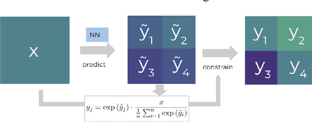
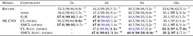
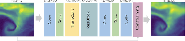
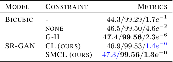
The availability of reliable, high-resolution climate and weather data is important to inform long-term decisions on climate adaptation and mitigation and to guide rapid responses to extreme events. Forecasting models are limited by computational costs and therefore often predict quantities at a coarse spatial resolution. Statistical downscaling can provide an efficient method of upsampling low-resolution data. In this field, deep learning has been applied successfully, often using methods from the super-resolution domain in computer vision. Despite often achieving visually compelling results, such models often violate conservation laws when predicting physical variables. In order to conserve important physical quantities, we develop methods that guarantee physical constraints are satisfied by a deep downscaling model while also increasing their performance according to traditional metrics. We introduce two ways of constraining the network: A renormalization layer added to the end of the neural network and a successive approach that scales with increasing upsampling factors. We show the applicability of our methods across different popular architectures and upsampling factors using ERA5 reanalysis data.
Wildfire risk forecast: An optimizable fire danger index
Mar 28, 2022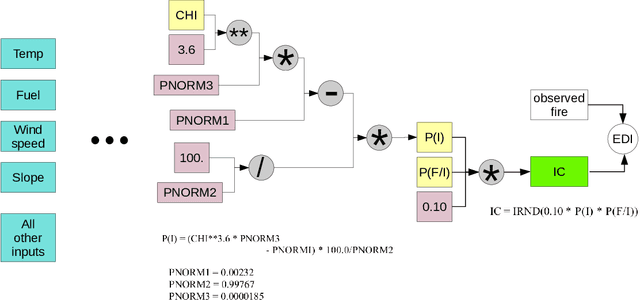
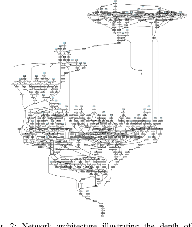
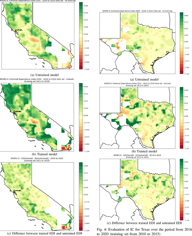
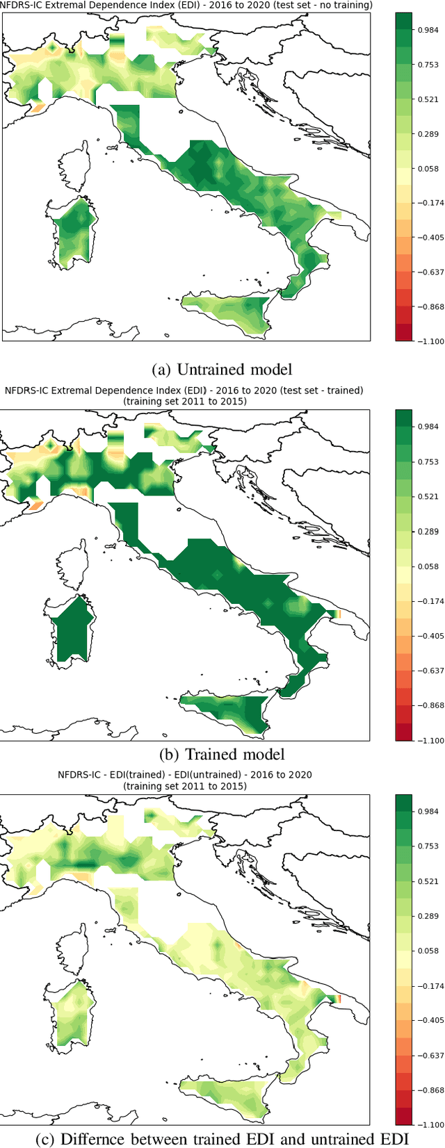
Wildfire events have caused severe losses in many places around the world and are expected to increase with climate change. Throughout the years many technologies have been developed to identify fire events early on and to simulate fire behavior once they have started. Another particularly helpful technology is fire risk indices, which use weather forcing to make advanced predictions of the risk of fire. Predictions of fire risk indices can be used, for instance, to allocate resources in places with high risk. These indices have been developed over the years as empirical models with parameters that were estimated in lab experiments and field tests. These parameters, however, may not fit well all places where these models are used. In this paper we propose a novel implementation of one index (NFDRS IC) as a differentiable function in which one can optimize its internal parameters via gradient descent. We leverage existing machine learning frameworks (PyTorch) to construct our model. This approach has two benefits: (1) the NFDRS IC parameters can be improved for each region using actual observed fire events, and (2) the internal variables remain intact for interpretations by specialists instead of meaningless hidden layers as in traditional neural networks. In this paper we evaluate our strategy with actual fire events for locations in the USA and Europe.