 Add to Chrome
 Add to Firefox
 Add to Edge
EXACT-MPPI: Exact Signed-Distance Navigation for Arbitrary-Footprint Robots from Point Clouds via Path Integral Control
May 28, 2026
Ground robots often carry payloads, implements, or other attachments that turn their effective footprint into complex, non-convex shapes. Navigating safely through clutter then requires reasoning about this true geometry, yet most local planners simplify it with convex or inflated proxies and rasterize sensor data into occupancy grids or distance fields. Both choices eliminate feasible motions when clearance is comparable to the footprint geometry. We present EXACT-MPPI, a training-free local navigation framework that maps local point-cloud observations and sparse guidance directly to motion commands, without any intermediate map representation. The framework embeds an analytic, exact signed-distance evaluator into a Model Predictive Path Integral (MPPI) controller. The footprint is represented as a simple polygon for general convex or concave planar shapes, with a rectangle-cover specialization for faster evaluation of rectilinear footprints, enabling footprint-aware collision costs without convex decomposition, inflation, or learned encoders. During each MPPI rollout, observed obstacle points are transformed into the predicted body frame and evaluated against the footprint. All operations are batched in JAX, leveraging GPU parallelism for real-time receding-horizon control. Experiments show that EXACT-MPPI accelerates batched distance evaluation over a learned point-to-robot baseline, preserves feasible motion where convex-footprint planners fail, and remains robust under dense static and moving obstacles. The same framework deploys on differential-drive, Ackermann, omnidirectional, and hybrid-mode platforms by changing only the footprint description and motion model without per-platform training. Pairing exact footprint geometry with sampling-based predictive control thus offers a practical, training-free path to footprint-aware local navigation across diverse robots.

Coverage Path Planning for Autonomous Sailboats in Inhomogeneous and Time-Varying Oceans: A Spatiotemporal Optimization Approach
Feb 13, 2026Autonomous sailboats are well suited for long-duration ocean observation due to their wind-driven endurance. However, their performance is highly anisotropic and strongly influenced by inhomogeneous and time-varying wind and current fields, limiting the effectiveness of existing coverage methods such as boustrophedon sweeping. Planning under these environmental and maneuvering constraints remains underexplored. This paper presents a spatiotemporal coverage path planning framework tailored to autonomous sailboats, combining (1) topology-based morphological constraints in the spatial domain to promote compact and continuous coverage, and (2) forecast-aware look-ahead planning in the temporal domain to anticipate environmental evolution and enable foresighted decision-making. Simulations conducted under stochastic inhomogeneous and time-varying ocean environments, including scenarios with partial directional accessibility, demonstrate that the proposed method generates efficient and feasible coverage paths where traditional strategies often fail. To the best of our knowledge, this study provides the first dedicated solution to the coverage path planning problem for autonomous sailboats operating in inhomogeneous and time-varying ocean environments, establishing a foundation for future cooperative multi-sailboat coverage.
Efficient and Safe Trajectory Planning for Autonomous Agricultural Vehicle Headland Turning in Cluttered Orchard Environments
Jan 18, 2025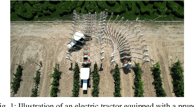
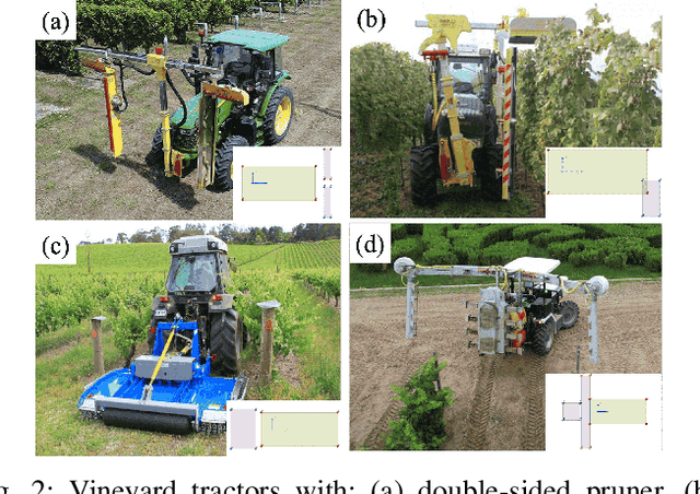
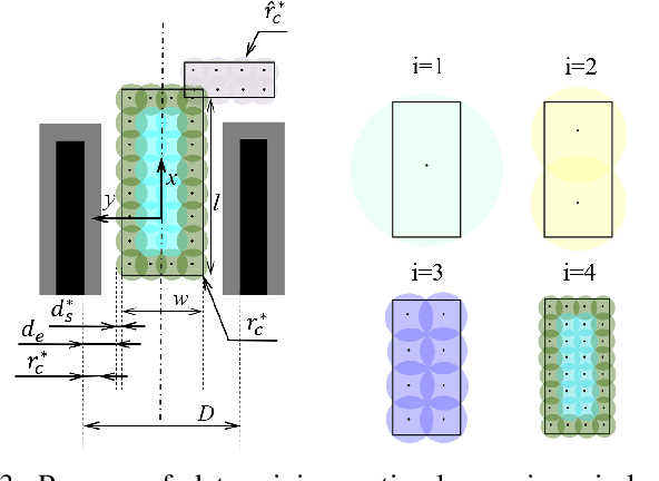
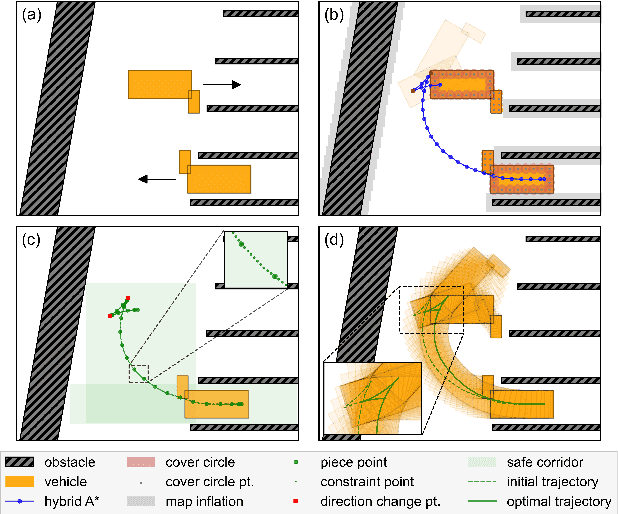
Autonomous agricultural vehicles (AAVs), including field robots and autonomous tractors, are becoming essential in modern farming by improving efficiency and reducing labor costs. A critical task in AAV operations is headland turning between crop rows. This task is challenging in orchards with limited headland space, irregular boundaries, operational constraints, and static obstacles. While traditional trajectory planning methods work well in arable farming, they often fail in cluttered orchard environments. This letter presents a novel trajectory planner that enhances the safety and efficiency of AAV headland maneuvers, leveraging advancements in autonomous driving. Our approach includes an efficient front-end algorithm and a high-performance back-end optimization. Applied to vehicles with various implements, it outperforms state-of-the-art methods in both standard and challenging orchard fields. This work bridges agricultural and autonomous driving technologies, facilitating a broader adoption of AAVs in complex orchards.
VE: Modeling Multivariate Time Series Correlation with Variate Embedding
Sep 10, 2024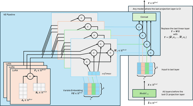
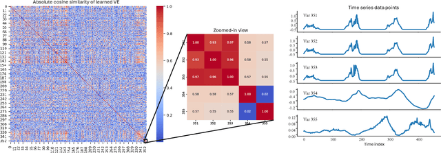
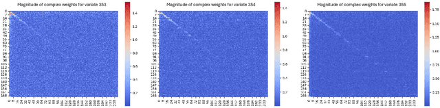
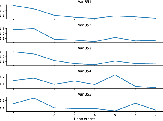
Multivariate time series forecasting relies on accurately capturing the correlations among variates. Current channel-independent (CI) models and models with a CI final projection layer are unable to capture these dependencies. In this paper, we present the variate embedding (VE) pipeline, which learns a unique and consistent embedding for each variate and combines it with Mixture of Experts (MoE) and Low-Rank Adaptation (LoRA) techniques to enhance forecasting performance while controlling parameter size. The VE pipeline can be integrated into any model with a CI final projection layer to improve multivariate forecasting. The learned VE effectively groups variates with similar temporal patterns and separates those with low correlations. The effectiveness of the VE pipeline is demonstrated through extensive experiments on four widely-used datasets. The code is available at: \url{https://github.com/swang-song/VE}.