 Add to Chrome
 Add to Firefox
 Add to Edge
GeoMamba: A Geometry-driven MambaVision Framework and Dataset for Fine-grained Optical-SAR Object Retrieval
May 19, 2026Multi-source remote sensing enables complementary observation of ground objects, while cross-modal fine-grained object retrieval remains challenging, especially under unaligned optical and SAR conditions. Unlike conventional retrieval settings that rely on paired or spatially aligned samples, practical optical-SAR retrieval is affected by substantial modality discrepancy, speckle noise, and structural inconsistency, which limit robust cross-modal representation learning. To address this problem, we propose GeoMamba, a geometry-driven framework tailored for optical-SAR fine-grained retrieval. Specifically, GeoMamba introduces a Geometric Feature Injection (GFI) module that enhances cross-modal feature interaction and incorporates structural priors, thereby improving the robustness of SAR representations and promoting geometry-consistent feature learning. In addition, a Geometric Consistency Constraint (GCC) module, together with a Deep Supervision (DS) strategy, imposes hierarchical geometric constraints using classical operators, which helps preserve informative object structures during representation learning. We further construct a new dataset, FGOS-as, containing 11 aerospace and maritime categories for evaluating unaligned cross-modal fine-grained object retrieval in realistic remote sensing scenarios. Extensive experiments on FGOS-as demonstrate that GeoMamba outperforms existing methods, achieving 63.3% mAP and 77.0% Rank-1 accuracy in all-to-all retrieval setting.
Open-Vocabulary Semantic Segmentation Network Integrating Object-Level Label and Scene-Level Semantic Features for Multimodal Remote Sensing Images
Apr 27, 2026Semantic segmentation of multi-modal remote sensing imagery plays a pivotal role in land use/land cover (LULC) mapping, environmental monitoring, and precision earth observation. Current multi-modal approaches mainly focus on integrating complementary visual modalities, yet neglect the incorporating of non-visual textual data - a rich source of knowledge that can bridge semantic gaps between visual patterns and real-world concepts. To address this limitation, we propose TSMNet, a text supervised multi-modal open vocabulary semantic segmentation network that synergistically integrates textual supervision with visual representation for open-vocabulary semantic segmentation. Unlike conventional multi-modal segmentation frameworks, TSMNet introduces a dual-branch text encoder to extract both scene-level semantic and object-level label information from various textual data, enabling dynamic cross-modal fusion. These text-derived features dynamically interact with visual embeddings through the proposed text-guided visual semantic fusion module, enabling domain-aware feature refinement and human-interpretable decision-making. To verify our method, we innovatively construct two new multi-modal datasets, and carry out extensive experiments to make a comprehensive comparison between the proposed method and other state-of-the-art (SOTA) semantic segmentation models. Results demonstrate that TSMNet achieves superior segmentation accuracy while exhibiting robust generalization capabilities across diverse geographical and sensor-specific scenarios. This work establishes a new paradigm for explainable remote sensing analysis, demonstrating that textual knowledge integration significantly enhances model generalizability. The source code will be available at https://github.com/yeyuanxin110/TSMNet
Observe Less, Understand More: Cost-aware Cross-scale Observation for Remote Sensing Understanding
Apr 13, 2026Remote sensing understanding inherently requires multi-resolution observation, since different targets and application tasks demand different levels of spatial detail. While low-resolution (LR) imagery enables efficient global observation, high-resolution (HR) imagery provides critical local details at much higher acquisition cost and limited coverage. This motivates a cross-scale sensing strategy that selectively acquires HR imagery from LR-based global perception to improve task performance under constrained cost. Existing methods for HR sampling methods typically make selection decisions from isolated LR patches, which ignore fine-grained intra-patch importance and cross-patch contextual interactions, leading to fragmented feature representation and suboptimal scene reasoning under sparse HR observations. To address this issue, we formulate cross-scale remote sensing understanding as a unified cost-aware problem that couples fine-grained HR sampling with cross-patch representation prediction, enabling more effective task reasoning with fewer HR observations. Furthermore, we present GL-10M, a large-scale benchmark of 10 million spatially aligned multi-resolution images, enabling systematic evaluation of budget-constrained cross-scale reasoning in remote sensing. Extensive experiments on recognition and retrieval tasks show that our method consistently achieves a superior performance-cost trade-off.
SGMA: Semantic-Guided Modality-Aware Segmentation for Remote Sensing with Incomplete Multimodal Data
Mar 03, 2026Multimodal semantic segmentation integrates complementary information from diverse sensors for remote sensing Earth observation. However, practical systems often encounter missing modalities due to sensor failures or incomplete coverage, termed Incomplete Multimodal Semantic Segmentation (IMSS). IMSS faces three key challenges: (1) multimodal imbalance, where dominant modalities suppress fragile ones; (2) intra-class variation in scale, shape, and orientation across modalities; and (3) cross-modal heterogeneity with conflicting cues producing inconsistent semantic responses. Existing methods rely on contrastive learning or joint optimization, which risk over-alignment, discarding modality-specific cues or imbalanced training, favoring robust modalities, while largely overlooking intra-class variation and cross-modal heterogeneity. To address these limitations, we propose the Semantic-Guided Modality-Aware (SGMA) framework, which ensures balanced multimodal learning while reducing intra-class variation and reconciling cross-modal inconsistencies through semantic guidance. SGMA introduces two complementary plug-and-play modules: (1) Semantic-Guided Fusion (SGF) module extracts multi-scale, class-wise semantic prototypes that capture consistent categorical representations across modalities, estimates per-modality robustness based on prototype-feature alignment, and performs adaptive fusion weighted by robustness scores to mitigate intra-class variation and cross-modal heterogeneity; (2) Modality-Aware Sampling (MAS) module leverages robustness estimations from SGF to dynamically reweight training samples, prioritizing challenging samples from fragile modalities to address modality imbalance. Extensive experiments across multiple datasets and backbones demonstrate that SGMA consistently outperforms state-of-the-art methods, with particularly significant improvements in fragile modalities.
DeTracker: Motion-decoupled Vehicle Detection and Tracking in Unstabilized Satellite Videos
Jan 14, 2026Satellite videos provide continuous observations of surface dynamics but pose significant challenges for multi-object tracking (MOT), especially under unstabilized conditions where platform jitter and the weak appearance of tiny objects jointly degrade tracking performance. To address this problem, we propose DeTracker, a joint detection-and-tracking framework tailored for unstabilized satellite videos. DeTracker introduces a Global--Local Motion Decoupling (GLMD) module that explicitly separates satellite platform motion from true object motion through global alignment and local refinement, leading to improved trajectory stability and motion estimation accuracy. In addition, a Temporal Dependency Feature Pyramid (TDFP) module is developed to perform cross-frame temporal feature fusion, enhancing the continuity and discriminability of tiny-object representations. We further construct a new benchmark dataset, SDM-Car-SU, which simulates multi-directional and multi-speed platform motions to enable systematic evaluation of tracking robustness under varying motion perturbations. Extensive experiments on both simulated and real unstabilized satellite videos demonstrate that DeTracker significantly outperforms existing methods, achieving 61.1% MOTA on SDM-Car-SU and 47.3% MOTA on real satellite video data.
SDM-Car: A Dataset for Small and Dim Moving Vehicles Detection in Satellite Videos
Dec 24, 2024


Vehicle detection and tracking in satellite video is essential in remote sensing (RS) applications. However, upon the statistical analysis of existing datasets, we find that the dim vehicles with low radiation intensity and limited contrast against the background are rarely annotated, which leads to the poor effect of existing approaches in detecting moving vehicles under low radiation conditions. In this paper, we address the challenge by building a \textbf{S}mall and \textbf{D}im \textbf{M}oving Cars (SDM-Car) dataset with a multitude of annotations for dim vehicles in satellite videos, which is collected by the Luojia 3-01 satellite and comprises 99 high-quality videos. Furthermore, we propose a method based on image enhancement and attention mechanisms to improve the detection accuracy of dim vehicles, serving as a benchmark for evaluating the dataset. Finally, we assess the performance of several representative methods on SDM-Car and present insightful findings. The dataset is openly available at https://github.com/TanedaM/SDM-Car.
An Improved End-to-End Multi-Target Tracking Method Based on Transformer Self-Attention
Nov 11, 2022


This study proposes an improved end-to-end multi-target tracking algorithm that adapts to multi-view multi-scale scenes based on the self-attentive mechanism of the transformer's encoder-decoder structure. A multi-dimensional feature extraction backbone network is combined with a self-built semantic raster map, which is stored in the encoder for correlation and generates target position encoding and multi-dimensional feature vectors. The decoder incorporates four methods: spatial clustering and semantic filtering of multi-view targets, dynamic matching of multi-dimensional features, space-time logic-based multi-target tracking, and space-time convergence network (STCN)-based parameter passing. Through the fusion of multiple decoding methods, muti-camera targets are tracked in three dimensions: temporal logic, spatial logic, and feature matching. For the MOT17 dataset, this study's method significantly outperforms the current state-of-the-art method MiniTrackV2 [49] by 2.2% to 0.836 on Multiple Object Tracking Accuracy(MOTA) metric. Furthermore, this study proposes a retrospective mechanism for the first time, and adopts a reverse-order processing method to optimise the historical mislabeled targets for improving the Identification F1-score(IDF1). For the self-built dataset OVIT-MOT01, the IDF1 improves from 0.948 to 0.967, and the Multi-camera Tracking Accuracy(MCTA) improves from 0.878 to 0.909, which significantly improves the continuous tracking accuracy and scene adaptation. This research method introduces a new attentional tracking paradigm which is able to achieve state-of-the-art performance on multi-target tracking (MOT17 and OVIT-MOT01) tasks.
A Light-Weighted Convolutional Neural Network for Bitemporal SAR Image Change Detection
Jun 21, 2020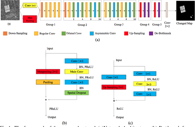
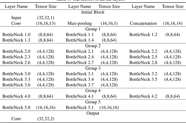
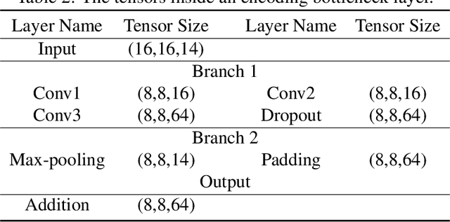
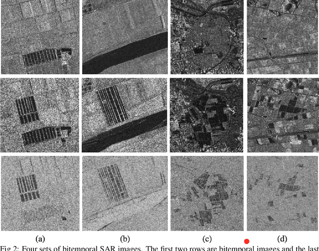
Recently, many Convolution Neural Networks (CNN) have been successfully employed in bitemporal SAR image change detection. However, most of the existing networks are too heavy and occupy a large volume of memory for storage and calculation. Motivated by this, in this paper, we propose a lightweight neural network to reduce the computational and spatial complexity and facilitate the change detection on an edge device. In the proposed network, we replace normal convolutional layers with bottleneck layers that keep the same number of channels between input and output. Next, we employ dilated convolutional kernels with a few non-zero entries that reduce the running time in convolutional operators. Comparing with the conventional convolutional neural network, our light-weighted neural network will be more efficient with fewer parameters. We verify our light-weighted neural network on four sets of bitemporal SAR images. The experimental results show that the proposed network can obtain better performance than the conventional CNN and has better model generalization, especially on the challenging datasets with complex scenes.
SAR Image Change Detection via Spatial Metric Learning with an Improved Mahalanobis Distance
Jun 19, 2019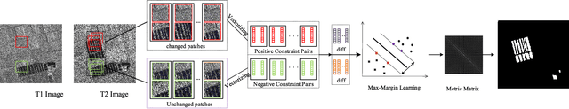
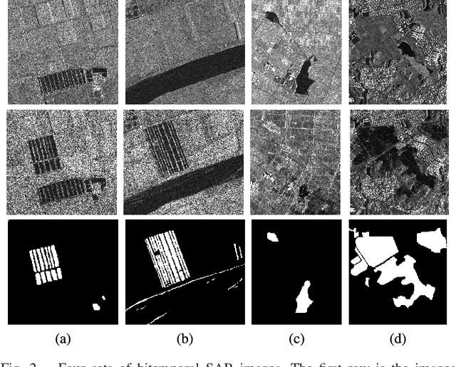
The log-ratio (LR) operator has been widely employed to generate the difference image for synthetic aperture radar (SAR) image change detection. However, the difference image generated by this pixel-wise operator can be subject to SAR images speckle and unavoidable registration errors between bitemporal SAR images. In this letter, we proposed a spatial metric learning method to obtain a difference image more robust to the speckle by learning a metric from a set of constraint pairs. In the proposed method, spatial context is considered in constructing constraint pairs, each of which consists of patches in the same location of bitemporal SAR images. Then, a semi-definite positive metric matrix $\bf M$ can be obtained by the optimization with the max-margin criterion. Finally, we verify our proposed method on four challenging datasets of bitemporal SAR images. Experimental results demonstrate that the difference map obtained by our proposed method outperforms than other state-of-art methods.
Imbalanced Learning-based Automatic SAR Images Change Detection by Morphologically Supervised PCA-Net
Jun 19, 2019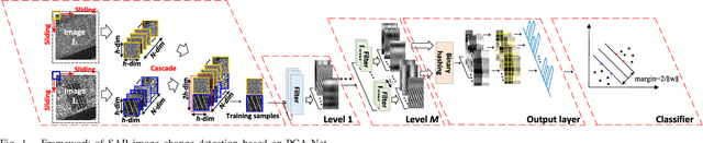
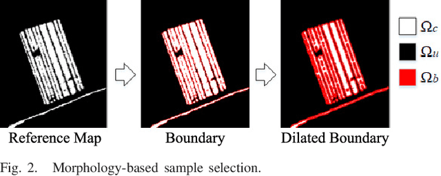
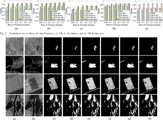
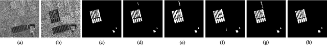
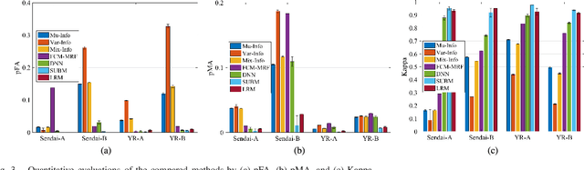
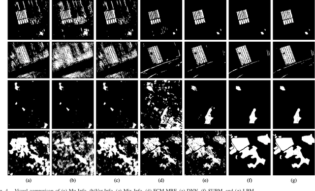
Change detection is a quite challenging task due to the imbalance between unchanged and changed class. In addition, the traditional difference map generated by log-ratio is subject to the speckle, which will reduce the accuracy. In this letter, an imbalanced learning-based change detection is proposed based on PCA network (PCA-Net), where a supervised PCA-Net is designed to obtain the robust features directly from given multitemporal SAR images instead of a difference map. Furthermore, to tackle with the imbalance between changed and unchanged classes, we propose a morphologically supervised learning method, where the knowledge in the pixels near the boundary between two classes are exploited to guide network training. Finally, our proposed PCA-Net can be trained by the datasets with available reference maps and applied to a new dataset, which is quite practical in change detection projects. Our proposed method is verified on five sets of multiple temporal SAR images. It is demonstrated from the experiment results that with the knowledge in training samples from the boundary, the learned features benefit for change detection and make the proposed method outperforms than supervised methods trained by randomly drawing samples.