 Add to Chrome
 Add to Firefox
 Add to Edge
Heterogeneous SAR-optical fusion for near-real-time land use and land cover mapping under cloud contamination: A novel framework and global benchmark dataset
Jun 16, 2026
Optical remote sensing imagery is frequently degraded by cloud and cloud-shadow contamination, which limits its reliability for near-real-time land use and land cover (LULC) mapping. Although synthetic aperture radar (SAR) can provide cloud-penetrating structural information, existing SAR-optical fusion methods often assume reliable optical observations and insufficiently address the semantic uncertainty introduced by cloud contamination. To address this issue, we propose CloudLULC-Net, an end-to-end heterogeneous SAR-optical fusion framework that directly predicts LULC maps from cloud-contaminated Sentinel-2 imagery and temporally adjacent Sentinel-1 SAR observations. The proposed network incorporates optical reliability modulation to suppress unreliable optical responses, heterogeneous information adaptive aggregation to model high-order spatial-channel interactions between optical and SAR representations, and a unified semantic mapping transformer to organize fused features in a LULC-oriented latent space. A semantic anchor-guided optimization strategy is further introduced to improve the consistency of intermediate semantic representations. To support this task, we construct CloudLULC-Set, a large-scale benchmark dataset containing 40,223 curated SAR-optical-label triplets with pixel-level LULC annotations across diverse geographic regions and cloud conditions. Experimental results show that CloudLULC-Net achieves an OA of 86.60%, an F1-score of 83.29%, and an mIoU of 73.51%, outperforming representative heterogeneous reconstruction-first and end-to-end SAR-optical mapping methods. Comparisons with existing global LULC products and analyses under different cloud-cover levels further demonstrate the robustness and practical value of CloudLULC-Net for target-date LULC mapping in cloud-prone regions.The project is publicly available at: https://github.com/RSIIPAC/CloudLULC

DeTracker: Motion-decoupled Vehicle Detection and Tracking in Unstabilized Satellite Videos
Jan 14, 2026Satellite videos provide continuous observations of surface dynamics but pose significant challenges for multi-object tracking (MOT), especially under unstabilized conditions where platform jitter and the weak appearance of tiny objects jointly degrade tracking performance. To address this problem, we propose DeTracker, a joint detection-and-tracking framework tailored for unstabilized satellite videos. DeTracker introduces a Global--Local Motion Decoupling (GLMD) module that explicitly separates satellite platform motion from true object motion through global alignment and local refinement, leading to improved trajectory stability and motion estimation accuracy. In addition, a Temporal Dependency Feature Pyramid (TDFP) module is developed to perform cross-frame temporal feature fusion, enhancing the continuity and discriminability of tiny-object representations. We further construct a new benchmark dataset, SDM-Car-SU, which simulates multi-directional and multi-speed platform motions to enable systematic evaluation of tracking robustness under varying motion perturbations. Extensive experiments on both simulated and real unstabilized satellite videos demonstrate that DeTracker significantly outperforms existing methods, achieving 61.1% MOTA on SDM-Car-SU and 47.3% MOTA on real satellite video data.
Thick Cloud Removal of Remote Sensing Images Using Temporal Smoothness and Sparsity-Regularized Tensor Optimization
Sep 01, 2020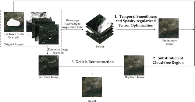
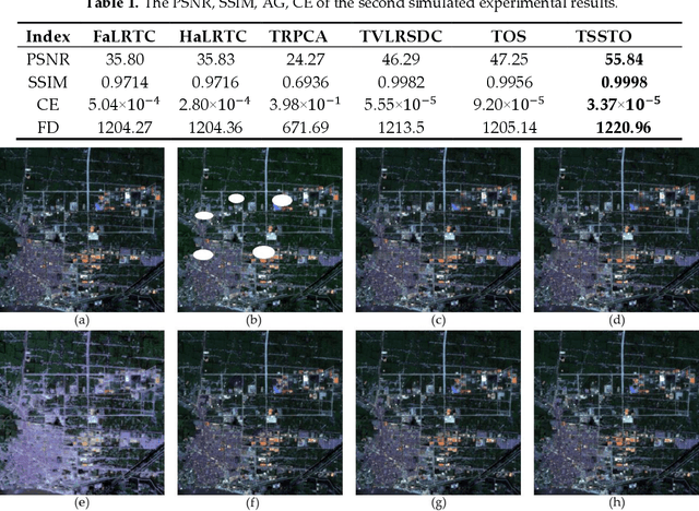
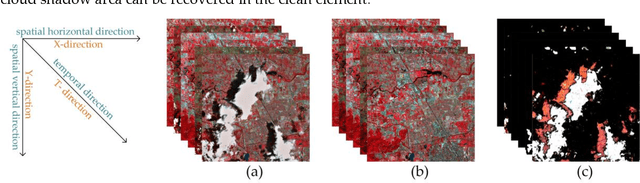

In remote sensing images, the presence of thick cloud accompanying cloud shadow is a high probability event, which can affect the quality of subsequent processing and limit the scenarios of application. Hence, removing the thick cloud and cloud shadow as well as recovering the cloud-contaminated pixels is indispensable to make good use of remote sensing images. In this paper, a novel thick cloud removal method for remote sensing images based on temporal smoothness and sparsity-regularized tensor optimization (TSSTO) is proposed. The basic idea of TSSTO is that the thick cloud and cloud shadow are not only sparse but also smooth along the horizontal and vertical direction in images while the clean images are smooth along the temporal direction between images. Therefore, the sparsity norm is used to boost the sparsity of the cloud and cloud shadow, and unidirectional total variation (UTV) regularizers are applied to ensure the unidirectional smoothness. This paper utilizes alternation direction method of multipliers to solve the presented model and generate the cloud and cloud shadow element as well as the clean element. The cloud and cloud shadow element is purified to get the cloud area and cloud shadow area. Then, the clean area of the original cloud-contaminated images is replaced to the corresponding area of the clean element. Finally, the reference image is selected to reconstruct details of the cloud area and cloud shadow area using the information cloning method. A series of experiments are conducted both on simulated and real cloud-contaminated images from different sensors and with different resolutions, and the results demonstrate the potential of the proposed TSSTO method for removing cloud and cloud shadow from both qualitative and quantitative viewpoints.
Spot Evasion Attacks: Adversarial Examples for License Plate Recognition Systems with Convolutional Neural Networks
Nov 28, 2019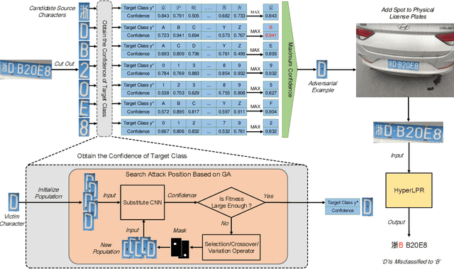
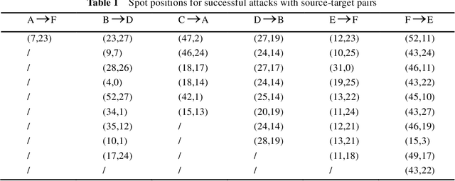
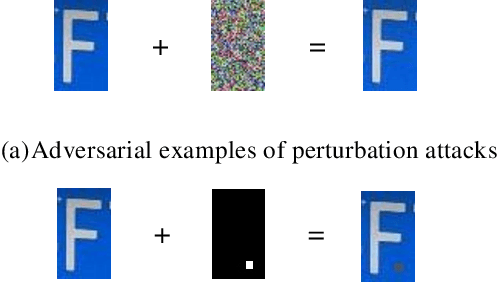
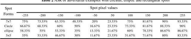
Recent studies have shown convolution neural networks (CNNs) for image recognition are vulnerable to evasion attacks with carefully manipulated adversarial examples. Previous work primarily focused on how to generate adversarial examples closed to source images, by introducing pixel-level perturbations into the whole or specific part of images. In this paper, we propose an evasion attack on CNN classifiers in the context of License Plate Recognition (LPR), which adds predetermined perturbations to specific regions of license plate images, simulating some sort of naturally formed spots (such as sludge, etc.). Therefore, the problem is modeled as an optimization process searching for optimal perturbation positions, which is different from previous work that consider pixel values as decision variables. Notice that this is a complex nonlinear optimization problem, and we use a genetic-algorithm based approach to obtain optimal perturbation positions. In experiments, we use the proposed algorithm to generate various adversarial examples in the form of rectangle, circle, ellipse and spots cluster. Experimental results show that these adversarial examples are almost ignored by human eyes, but can fool HyperLPR with high attack success rate over 93%. Therefore, we believe that this kind of spot evasion attacks would pose a great threat to current LPR systems, and needs to be investigated further by the security community.