 Add to Chrome
 Add to Firefox
 Add to Edge
SSGA-Net: Stepwise Spatial Global-local Aggregation Networks for for Autonomous Driving
May 29, 2024


Visual-based perception is the key module for autonomous driving. Among those visual perception tasks, video object detection is a primary yet challenging one because of feature degradation caused by fast motion or multiple poses. Current models usually aggregate features from the neighboring frames to enhance the object representations for the task heads to generate more accurate predictions. Though getting better performance, these methods rely on the information from the future frames and suffer from high computational complexity. Meanwhile, the aggregation process is not reconfigurable during the inference time. These issues make most of the existing models infeasible for online applications. To solve these problems, we introduce a stepwise spatial global-local aggregation network. Our proposed models mainly contain three parts: 1). Multi-stage stepwise network gradually refines the predictions and object representations from the previous stage; 2). Spatial global-local aggregation fuses the local information from the neighboring frames and global semantics from the current frame to eliminate the feature degradation; 3). Dynamic aggregation strategy stops the aggregation process early based on the refinement results to remove redundancy and improve efficiency. Extensive experiments on the ImageNet VID benchmark validate the effectiveness and efficiency of our proposed models.
BadPart: Unified Black-box Adversarial Patch Attacks against Pixel-wise Regression Tasks
Apr 01, 2024


Pixel-wise regression tasks (e.g., monocular depth estimation (MDE) and optical flow estimation (OFE)) have been widely involved in our daily life in applications like autonomous driving, augmented reality and video composition. Although certain applications are security-critical or bear societal significance, the adversarial robustness of such models are not sufficiently studied, especially in the black-box scenario. In this work, we introduce the first unified black-box adversarial patch attack framework against pixel-wise regression tasks, aiming to identify the vulnerabilities of these models under query-based black-box attacks. We propose a novel square-based adversarial patch optimization framework and employ probabilistic square sampling and score-based gradient estimation techniques to generate the patch effectively and efficiently, overcoming the scalability problem of previous black-box patch attacks. Our attack prototype, named BadPart, is evaluated on both MDE and OFE tasks, utilizing a total of 7 models. BadPart surpasses 3 baseline methods in terms of both attack performance and efficiency. We also apply BadPart on the Google online service for portrait depth estimation, causing 43.5% relative distance error with 50K queries. State-of-the-art (SOTA) countermeasures cannot defend our attack effectively.
Text Is MASS: Modeling as Stochastic Embedding for Text-Video Retrieval
Mar 26, 2024The increasing prevalence of video clips has sparked growing interest in text-video retrieval. Recent advances focus on establishing a joint embedding space for text and video, relying on consistent embedding representations to compute similarity. However, the text content in existing datasets is generally short and concise, making it hard to fully describe the redundant semantics of a video. Correspondingly, a single text embedding may be less expressive to capture the video embedding and empower the retrieval. In this study, we propose a new stochastic text modeling method T-MASS, i.e., text is modeled as a stochastic embedding, to enrich text embedding with a flexible and resilient semantic range, yielding a text mass. To be specific, we introduce a similarity-aware radius module to adapt the scale of the text mass upon the given text-video pairs. Plus, we design and develop a support text regularization to further control the text mass during the training. The inference pipeline is also tailored to fully exploit the text mass for accurate retrieval. Empirical evidence suggests that T-MASS not only effectively attracts relevant text-video pairs while distancing irrelevant ones, but also enables the determination of precise text embeddings for relevant pairs. Our experimental results show a substantial improvement of T-MASS over baseline (3% to 6.3% by R@1). Also, T-MASS achieves state-of-the-art performance on five benchmark datasets, including MSRVTT, LSMDC, DiDeMo, VATEX, and Charades.
Image Translation as Diffusion Visual Programmers
Jan 30, 2024


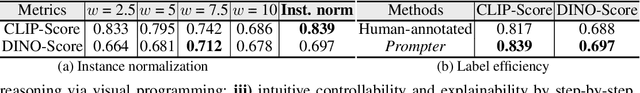
We introduce the novel Diffusion Visual Programmer (DVP), a neuro-symbolic image translation framework. Our proposed DVP seamlessly embeds a condition-flexible diffusion model within the GPT architecture, orchestrating a coherent sequence of visual programs (i.e., computer vision models) for various pro-symbolic steps, which span RoI identification, style transfer, and position manipulation, facilitating transparent and controllable image translation processes. Extensive experiments demonstrate DVP's remarkable performance, surpassing concurrent arts. This success can be attributed to several key features of DVP: First, DVP achieves condition-flexible translation via instance normalization, enabling the model to eliminate sensitivity caused by the manual guidance and optimally focus on textual descriptions for high-quality content generation. Second, the framework enhances in-context reasoning by deciphering intricate high-dimensional concepts in feature spaces into more accessible low-dimensional symbols (e.g., [Prompt], [RoI object]), allowing for localized, context-free editing while maintaining overall coherence. Last but not least, DVP improves systemic controllability and explainability by offering explicit symbolic representations at each programming stage, empowering users to intuitively interpret and modify results. Our research marks a substantial step towards harmonizing artificial image translation processes with cognitive intelligence, promising broader applications.
Facing the Elephant in the Room: Visual Prompt Tuning or Full Finetuning?
Jan 23, 2024


As the scale of vision models continues to grow, the emergence of Visual Prompt Tuning (VPT) as a parameter-efficient transfer learning technique has gained attention due to its superior performance compared to traditional full-finetuning. However, the conditions favoring VPT (the ``when") and the underlying rationale (the ``why") remain unclear. In this paper, we conduct a comprehensive analysis across 19 distinct datasets and tasks. To understand the ``when" aspect, we identify the scenarios where VPT proves favorable by two dimensions: task objectives and data distributions. We find that VPT is preferrable when there is 1) a substantial disparity between the original and the downstream task objectives (e.g., transitioning from classification to counting), or 2) a similarity in data distributions between the two tasks (e.g., both involve natural images). In exploring the ``why" dimension, our results indicate VPT's success cannot be attributed solely to overfitting and optimization considerations. The unique way VPT preserves original features and adds parameters appears to be a pivotal factor. Our study provides insights into VPT's mechanisms, and offers guidance for its optimal utilization.
Efficient Multimodal Semantic Segmentation via Dual-Prompt Learning
Dec 04, 2023


Multimodal (e.g., RGB-Depth/RGB-Thermal) fusion has shown great potential for improving semantic segmentation in complex scenes (e.g., indoor/low-light conditions). Existing approaches often fully fine-tune a dual-branch encoder-decoder framework with a complicated feature fusion strategy for achieving multimodal semantic segmentation, which is training-costly due to the massive parameter updates in feature extraction and fusion. To address this issue, we propose a surprisingly simple yet effective dual-prompt learning network (dubbed DPLNet) for training-efficient multimodal (e.g., RGB-D/T) semantic segmentation. The core of DPLNet is to directly adapt a frozen pre-trained RGB model to multimodal semantic segmentation, reducing parameter updates. For this purpose, we present two prompt learning modules, comprising multimodal prompt generator (MPG) and multimodal feature adapter (MFA). MPG works to fuse the features from different modalities in a compact manner and is inserted from shadow to deep stages to generate the multi-level multimodal prompts that are injected into the frozen backbone, while MPG adapts prompted multimodal features in the frozen backbone for better multimodal semantic segmentation. Since both the MPG and MFA are lightweight, only a few trainable parameters (3.88M, 4.4% of the pre-trained backbone parameters) are introduced for multimodal feature fusion and learning. Using a simple decoder (3.27M parameters), DPLNet achieves new state-of-the-art performance or is on a par with other complex approaches on four RGB-D/T semantic segmentation datasets while satisfying parameter efficiency. Moreover, we show that DPLNet is general and applicable to other multimodal tasks such as salient object detection and video semantic segmentation. Without special design, DPLNet outperforms many complicated models. Our code will be available at github.com/ShaohuaDong2021/DPLNet.
CML-MOTS: Collaborative Multi-task Learning for Multi-Object Tracking and Segmentation
Nov 02, 2023


The advancement of computer vision has pushed visual analysis tasks from still images to the video domain. In recent years, video instance segmentation, which aims to track and segment multiple objects in video frames, has drawn much attention for its potential applications in various emerging areas such as autonomous driving, intelligent transportation, and smart retail. In this paper, we propose an effective framework for instance-level visual analysis on video frames, which can simultaneously conduct object detection, instance segmentation, and multi-object tracking. The core idea of our method is collaborative multi-task learning which is achieved by a novel structure, named associative connections among detection, segmentation, and tracking task heads in an end-to-end learnable CNN. These additional connections allow information propagation across multiple related tasks, so as to benefit these tasks simultaneously. We evaluate the proposed method extensively on KITTI MOTS and MOTS Challenge datasets and obtain quite encouraging results.
ClusterFormer: Clustering As A Universal Visual Learner
Oct 01, 2023


This paper presents CLUSTERFORMER, a universal vision model that is based on the CLUSTERing paradigm with TransFORMER. It comprises two novel designs: 1. recurrent cross-attention clustering, which reformulates the cross-attention mechanism in Transformer and enables recursive updates of cluster centers to facilitate strong representation learning; and 2. feature dispatching, which uses the updated cluster centers to redistribute image features through similarity-based metrics, resulting in a transparent pipeline. This elegant design streamlines an explainable and transferable workflow, capable of tackling heterogeneous vision tasks (i.e., image classification, object detection, and image segmentation) with varying levels of clustering granularity (i.e., image-, box-, and pixel-level). Empirical results demonstrate that CLUSTERFORMER outperforms various well-known specialized architectures, achieving 83.41% top-1 acc. over ImageNet-1K for image classification, 54.2% and 47.0% mAP over MS COCO for object detection and instance segmentation, 52.4% mIoU over ADE20K for semantic segmentation, and 55.8% PQ over COCO Panoptic for panoptic segmentation. For its efficacy, we hope our work can catalyze a paradigm shift in universal models in computer vision.
E^2VPT: An Effective and Efficient Approach for Visual Prompt Tuning
Jul 25, 2023As the size of transformer-based models continues to grow, fine-tuning these large-scale pretrained vision models for new tasks has become increasingly parameter-intensive. Parameter-efficient learning has been developed to reduce the number of tunable parameters during fine-tuning. Although these methods show promising results, there is still a significant performance gap compared to full fine-tuning. To address this challenge, we propose an Effective and Efficient Visual Prompt Tuning (E^2VPT) approach for large-scale transformer-based model adaptation. Specifically, we introduce a set of learnable key-value prompts and visual prompts into self-attention and input layers, respectively, to improve the effectiveness of model fine-tuning. Moreover, we design a prompt pruning procedure to systematically prune low importance prompts while preserving model performance, which largely enhances the model's efficiency. Empirical results demonstrate that our approach outperforms several state-of-the-art baselines on two benchmarks, with considerably low parameter usage (e.g., 0.32% of model parameters on VTAB-1k). Our code is available at https://github.com/ChengHan111/E2VPT.
CLUSTSEG: Clustering for Universal Segmentation
May 03, 2023We present CLUSTSEG, a general, transformer-based framework that tackles different image segmentation tasks (i.e., superpixel, semantic, instance, and panoptic) through a unified neural clustering scheme. Regarding queries as cluster centers, CLUSTSEG is innovative in two aspects:1) cluster centers are initialized in heterogeneous ways so as to pointedly address task-specific demands (e.g., instance- or category-level distinctiveness), yet without modifying the architecture; and 2) pixel-cluster assignment, formalized in a cross-attention fashion, is alternated with cluster center update, yet without learning additional parameters. These innovations closely link CLUSTSEG to EM clustering and make it a transparent and powerful framework that yields superior results across the above segmentation tasks.