 Add to Chrome
 Add to Firefox
 Add to Edge
WinTA-GIL: Windowed Trajectory Alignment for GNSS-IMU-LiDAR Heading Refinement in Intermittent Signal Environments
Jul 06, 2026
Although multi-source fusion positioning systems have achieved significant progress, accurate and reliable heading estimation remains a critical challenge due to the lack of gravitational constraints and the inherent weak observability of heading in complex environments. Most existing methodologies are specifically tailored for the startup phase, relying on a singular initial alignment to establish the heading reference. Consequently, these approaches lack the adaptability required to refine heading estimates dynamically, which renders the system highly vulnerable to accumulated drift and observation noise during prolonged navigation or immediately following GNSS signal outages. To address these limitations, this paper proposes WinTA-GIL, a novel heading refinement framework that integrates information from Global Navigation Satellite System (GNSS), Inertial Measurement Unit (IMU), and Light Detection and Ranging (LiDAR) through a temporal window-based optimization strategy. Unlike conventional alignment methods restricted to the startup phase, WinTA-GIL leverages high-precision local trajectories from LiDAR-Inertial Odometry (LIO) to register against filtered GNSS observations. This approach transforms heading estimation into a repeatable, trajectory-based consistency optimization problem. In particular, an adaptive re-estimation mechanism based on state discrimination is incorporated to trigger heading corrections whenever necessary, thereby effectively suppressing the inertial drift accumulated during challenging conditions. Extensive experiments on both open-source and self-collected datasets demonstrate that WinTA-GIL significantly outperforms state-of-the-art approaches in both estimation accuracy and system robustness.

GTCN-G: A Residual Graph-Temporal Fusion Network for Imbalanced Intrusion Detection (Preprint)
Oct 08, 2025The escalating complexity of network threats and the inherent class imbalance in traffic data present formidable challenges for modern Intrusion Detection Systems (IDS). While Graph Neural Networks (GNNs) excel in modeling topological structures and Temporal Convolutional Networks (TCNs) are proficient in capturing time-series dependencies, a framework that synergistically integrates both while explicitly addressing data imbalance remains an open challenge. This paper introduces a novel deep learning framework, named Gated Temporal Convolutional Network and Graph (GTCN-G), engineered to overcome these limitations. Our model uniquely fuses a Gated TCN (G-TCN) for extracting hierarchical temporal features from network flows with a Graph Convolutional Network (GCN) designed to learn from the underlying graph structure. The core innovation lies in the integration of a residual learning mechanism, implemented via a Graph Attention Network (GAT). This mechanism preserves original feature information through residual connections, which is critical for mitigating the class imbalance problem and enhancing detection sensitivity for rare malicious activities (minority classes). We conducted extensive experiments on two public benchmark datasets, UNSW-NB15 and ToN-IoT, to validate our approach. The empirical results demonstrate that the proposed GTCN-G model achieves state-of-the-art performance, significantly outperforming existing baseline models in both binary and multi-class classification tasks.
A Real-time Degeneracy Sensing and Compensation Method for Enhanced LiDAR SLAM
Dec 10, 2024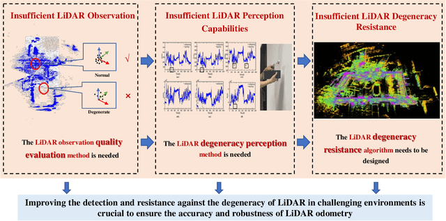
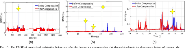
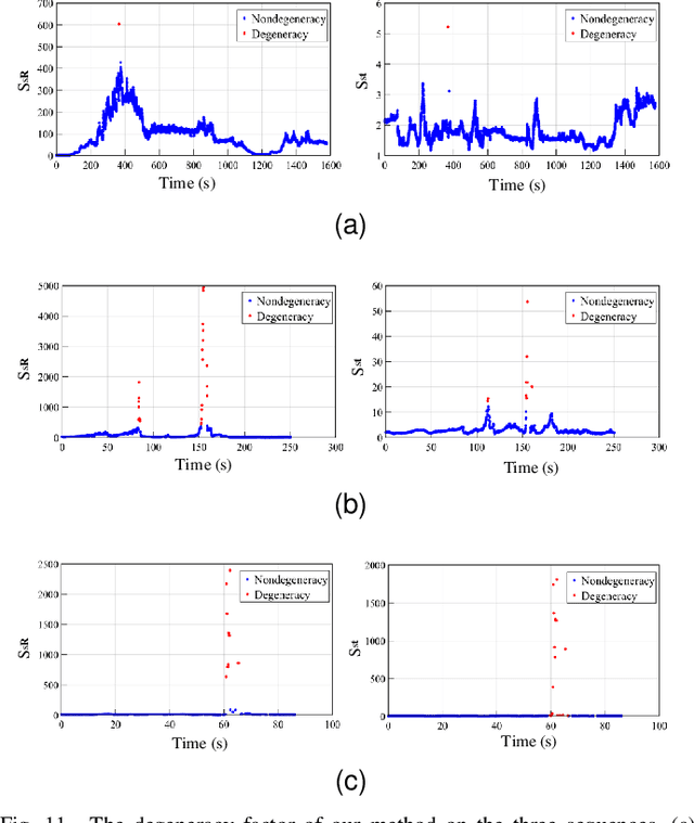
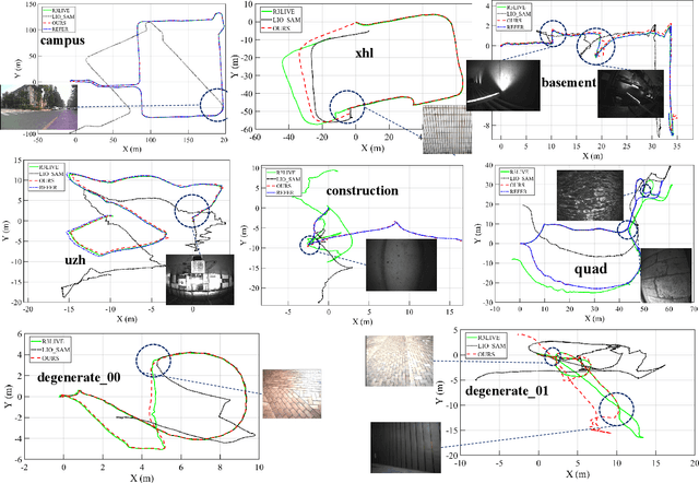
LiDAR is widely used in Simultaneous Localization and Mapping (SLAM) and autonomous driving. The LiDAR odometry is of great importance in multi-sensor fusion. However, in some unstructured environments, the point cloud registration cannot constrain the poses of the LiDAR due to its sparse geometric features, which leads to the degeneracy of multi-sensor fusion accuracy. To address this problem, we propose a novel real-time approach to sense and compensate for the degeneracy of LiDAR. Firstly, this paper introduces the degeneracy factor with clear meaning, which can measure the degeneracy of LiDAR. Then, the Density-Based Spatial Clustering of Applications with Noise (DBSCAN) clustering method adaptively perceives the degeneracy with better environmental generalization. Finally, the degeneracy perception results are utilized to fuse LiDAR and IMU, thus effectively resisting degeneracy effects. Experiments on our dataset show the method's high accuracy and robustness and validate our algorithm's adaptability to different environments and LiDAR scanning modalities.