 Add to Chrome
 Add to Firefox
 Add to Edge
Efficient Policy Learning with Hybrid Evaluation-Based Genetic Programming for Uncertain Agile Earth Observation Satellite Scheduling
Mar 09, 2026The Uncertain Agile Earth Observation Satellite Scheduling Problem (UAEOSSP) is a novel combinatorial optimization problem and a practical engineering challenge that aligns with the current demands of space technology development. It incorporates uncertainties in profit, resource consumption, and visibility, which may render pre-planned schedules suboptimal or even infeasible. Genetic Programming Hyper-Heuristic (GPHH) shows promise for evolving interpretable scheduling policies; however, their simulation-based evaluation incurs high computational costs. Moreover, the design of the constructive method, denoted as Online Scheduling Algorithm (OSA), directly affects fitness assessment, resulting in evaluation-dependent local optima within the policy space. To address these issues, this paper proposes a Hybrid Evaluation-based Genetic Programming (HE-GP) for effectively solving UAEOSSP. A Hybrid Evaluation (HE) mechanism is integrated into the policy-driven OSA, combining exact and approximate filtering modes: exact mode ensures evaluation accuracy through elaborately designed constraint verification modules, while approximate mode reduces computational overhead via simplified logic. HE-GP dynamically switches between evaluation models based on real-time evolutionary state information. Experiments on 16 simulated instance sets demonstrate that HE-GP significantly outperforms handcrafted heuristics and single-evaluation based GPHH, achieving substantial reductions in computational cost while maintaining excellent scheduling performance across diverse scenarios. Specifically, the average training time of HE-GP was reduced by 17.77\% compared to GP employing exclusively exact evaluation, while the optimal policy generated by HE-GP achieved the highest average ranks across all scenarios.
An effective Genetic Programming Hyper-Heuristic for Uncertain Agile Satellite Scheduling
Feb 15, 2026This paper investigates a novel problem, namely the Uncertain Agile Earth Observation Satellite Scheduling Problem (UAEOSSP). Unlike the static AEOSSP, it takes into account a range of uncertain factors (e.g., task profit, resource consumption, and task visibility) in order to reflect the reality that the actual information is inherently unknown beforehand. An effective Genetic Programming Hyper-Heuristic (GPHH) is designed to automate the generation of scheduling policies. The evolved scheduling policies can be utilized to adjust plans in real time and perform exceptionally well. Experimental results demonstrate that evolved scheduling policies significantly outperform both well-designed Look-Ahead Heuristics (LAHs) and Manually Designed Heuristics (MDHs). Specifically, the policies generated by GPHH achieve an average improvement of 5.03% compared to LAHs and 8.14% compared to MDHs.
Pheromone-Focused Ant Colony Optimization algorithm for path planning
Jan 12, 2026Ant Colony Optimization (ACO) is a prominent swarm intelligence algorithm extensively applied to path planning. However, traditional ACO methods often exhibit shortcomings, such as blind search behavior and slow convergence within complex environments. To address these challenges, this paper proposes the Pheromone-Focused Ant Colony Optimization (PFACO) algorithm, which introduces three key strategies to enhance the problem-solving ability of the ant colony. First, the initial pheromone distribution is concentrated in more promising regions based on the Euclidean distances of nodes to the start and end points, balancing the trade-off between exploration and exploitation. Second, promising solutions are reinforced during colony iterations to intensify pheromone deposition along high-quality paths, accelerating convergence while maintaining solution diversity. Third, a forward-looking mechanism is implemented to penalize redundant path turns, promoting smoother and more efficient solutions. These strategies collectively produce the focused pheromones to guide the ant colony's search, which enhances the global optimization capabilities of the PFACO algorithm, significantly improving convergence speed and solution quality across diverse optimization problems. The experimental results demonstrate that PFACO consistently outperforms comparative ACO algorithms in terms of convergence speed and solution quality.
EMOD: A Unified EEG Emotion Representation Framework Leveraging V-A Guided Contrastive Learning
Nov 14, 2025


Emotion recognition from EEG signals is essential for affective computing and has been widely explored using deep learning. While recent deep learning approaches have achieved strong performance on single EEG emotion datasets, their generalization across datasets remains limited due to the heterogeneity in annotation schemes and data formats. Existing models typically require dataset-specific architectures tailored to input structure and lack semantic alignment across diverse emotion labels. To address these challenges, we propose EMOD: A Unified EEG Emotion Representation Framework Leveraging Valence-Arousal (V-A) Guided Contrastive Learning. EMOD learns transferable and emotion-aware representations from heterogeneous datasets by bridging both semantic and structural gaps. Specifically, we project discrete and continuous emotion labels into a unified V-A space and formulate a soft-weighted supervised contrastive loss that encourages emotionally similar samples to cluster in the latent space. To accommodate variable EEG formats, EMOD employs a flexible backbone comprising a Triple-Domain Encoder followed by a Spatial-Temporal Transformer, enabling robust extraction and integration of temporal, spectral, and spatial features. We pretrain EMOD on 8 public EEG datasets and evaluate its performance on three benchmark datasets. Experimental results show that EMOD achieves the state-of-the-art performance, demonstrating strong adaptability and generalization across diverse EEG-based emotion recognition scenarios.
SoilX: Calibration-Free Comprehensive Soil Sensing Through Contrastive Cross-Component Learning
Nov 07, 2025Precision agriculture demands continuous and accurate monitoring of soil moisture (M) and key macronutrients, including nitrogen (N), phosphorus (P), and potassium (K), to optimize yields and conserve resources. Wireless soil sensing has been explored to measure these four components; however, current solutions require recalibration (i.e., retraining the data processing model) to handle variations in soil texture, characterized by aluminosilicates (Al) and organic carbon (C), limiting their practicality. To address this, we introduce SoilX, a calibration-free soil sensing system that jointly measures six key components: {M, N, P, K, C, Al}. By explicitly modeling C and Al, SoilX eliminates texture- and carbon-dependent recalibration. SoilX incorporates Contrastive Cross-Component Learning (3CL), with two customized terms: the Orthogonality Regularizer and the Separation Loss, to effectively disentangle cross-component interference. Additionally, we design a novel tetrahedral antenna array with an antenna-switching mechanism, which can robustly measure soil dielectric permittivity independent of device placement. Extensive experiments demonstrate that SoilX reduces estimation errors by 23.8% to 31.5% over baselines and generalizes well to unseen fields.
GWRF: A Generalizable Wireless Radiance Field for Wireless Signal Propagation Modeling
Feb 08, 2025


We present Generalizable Wireless Radiance Fields (GWRF), a framework for modeling wireless signal propagation at arbitrary 3D transmitter and receiver positions. Unlike previous methods that adapt vanilla Neural Radiance Fields (NeRF) from the optical to the wireless signal domain, requiring extensive per-scene training, GWRF generalizes effectively across scenes. First, a geometry-aware Transformer encoder-based wireless scene representation module incorporates information from geographically proximate transmitters to learn a generalizable wireless radiance field. Second, a neural-driven ray tracing algorithm operates on this field to automatically compute signal reception at the receiver. Experimental results demonstrate that GWRF outperforms existing methods on single scenes and achieves state-of-the-art performance on unseen scenes.
See Behind Walls in Real-time Using Aerial Drones and Augmented Reality
Oct 17, 2024


This work presents ARD2, a framework that enables real-time through-wall surveillance using two aerial drones and an augmented reality (AR) device. ARD2 consists of two main steps: target direction estimation and contour reconstruction. In the first stage, ARD2 leverages geometric relationships between the drones, the user, and the target to project the target's direction onto the user's AR display. In the second stage, images from the drones are synthesized to reconstruct the target's contour, allowing the user to visualize the target behind walls. Experimental results demonstrate the system's accuracy in both direction estimation and contour reconstruction.
MARLP: Time-series Forecasting Control for Agricultural Managed Aquifer Recharge
Jul 01, 2024


The rapid decline in groundwater around the world poses a significant challenge to sustainable agriculture. To address this issue, agricultural managed aquifer recharge (Ag-MAR) is proposed to recharge the aquifer by artificially flooding agricultural lands using surface water. Ag-MAR requires a carefully selected flooding schedule to avoid affecting the oxygen absorption of crop roots. However, current Ag-MAR scheduling does not take into account complex environmental factors such as weather and soil oxygen, resulting in crop damage and insufficient recharging amounts. This paper proposes MARLP, the first end-to-end data-driven control system for Ag-MAR. We first formulate Ag-MAR as an optimization problem. To that end, we analyze four-year in-field datasets, which reveal the multi-periodicity feature of the soil oxygen level trends and the opportunity to use external weather forecasts and flooding proposals as exogenous clues for soil oxygen prediction. Then, we design a two-stage forecasting framework. In the first stage, it extracts both the cross-variate dependency and the periodic patterns from historical data to conduct preliminary forecasting. In the second stage, it uses weather-soil and flooding-soil causality to facilitate an accurate prediction of soil oxygen levels. Finally, we conduct model predictive control (MPC) for Ag-MAR flooding. To address the challenge of large action spaces, we devise a heuristic planning module to reduce the number of flooding proposals to enable the search for optimal solutions. Real-world experiments show that MARLP reduces the oxygen deficit ratio by 86.8% while improving the recharging amount in unit time by 35.8%, compared with the previous four years.
Satellite downlink scheduling under breakpoint resume mode
Jul 04, 2022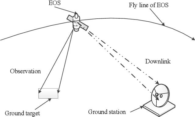
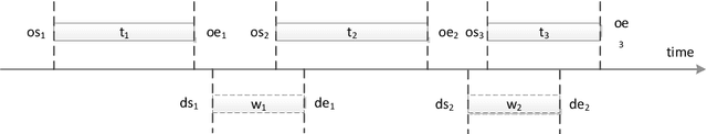
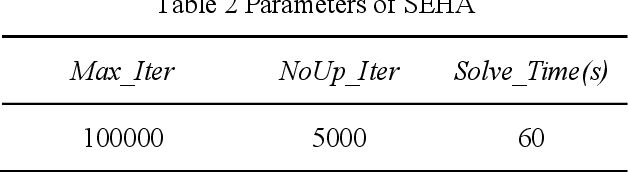
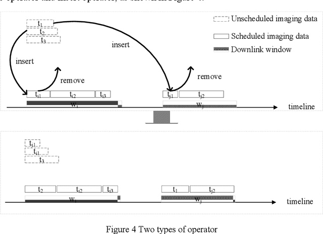
A novel problem called satellite downlink scheduling problem (SDSP) under breakpoint resume mode (SDSP-BRM) is studied in our paper. Compared to the traditional SDSP where an imaging data has to be completely downloaded at one time, SDSP-BRM allows the data of an imaging data be broken into a number of pieces which can be downloaded in different playback windows. By analyzing the characteristics of SDSP-BRM, we first propose a mixed integer programming model for its formulation and then prove the NP-hardness of SDSP-BRM. To solve the problem, we design a simple and effective heuristic algorithm (SEHA) where a number of problem-tailored move operators are proposed for local searching. Numerical results on a set of well-designed scenarios demonstrate the efficiency of the proposed algorithm in comparison to the general purpose CPLEX solver. We conduct additional experiments to shed light on the impact of the segmental strategy on the overall performance of the proposed SEHA.